Items Similar to Old Map of the Lower Bishopric of Münster (1726-1750) by Sanson & Ottens, c.1750


Want more images or videos?
Request additional images or videos from the seller
1 of 8
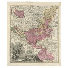
Old Map of the Lower Bishopric of Münster (1726-1750) by Sanson & Ottens, c.1750
$825.65
£608.66
€690
CA$1,142.38
A$1,239.54
CHF 657.55
MX$15,221.41
NOK 8,131.77
SEK 7,700.78
DKK 5,253.57
About the Item
Historical Map of the Lower Bishopric of Münster (1726-1750) by Sanson & Ottens – Hand-Colored Copperplate Engraving
The map titled "BASSE PARTIE DE L'EVESCHE DE MUNSTER" is a detailed historical depiction of the lower portion of the Bishopric of Münster, a region historically significant in present-day Germany. It is a hand-colored copperplate engraving, created by Nicolas Sanson and later revised and augmented by Reinier and Joshua Ottens of Amsterdam between 1726 and 1750.
This map is particularly interesting due to its detailed representation of territorial divisions, cities, rivers, and other geographical features. The use of hand coloring enhances the clarity of boundaries and regions, emphasizing the political and administrative landscape of the time. The map reflects a collaboration between notable cartographers from France (Sanson) and the Netherlands (Ottens), showcasing the blending of French cartographic precision with Dutch expertise in map production during the 18th century. The map was likely intended for use by scholars, politicians, or merchants, providing insights into the geopolitical environment of the Bishopric of Münster during this period.
From the map "BASSE PARTIE DE L'EVESCHE DE MUNSTER," some interesting and historically significant places or cities that collectors often look for include:
1. Münster – the central city of the bishopric, renowned for its ecclesiastical and historical significance in Westphalia.
2. Groningen – a major historical city in the north, known for its cultural and economic importance.
3. Dortmund – an important city in the region, often sought for its historical trade connections.
4. Osnabrück – significant for its role in the Peace of Westphalia treaties.
5. Lingen – a smaller but historically notable town in the region.
6. Wildeshausen – a historic town in Oldenburg with religious importance.
7. Dollard Bay (De Dollard) – a geographical feature in the northwest, historically significant due to its fluctuating coastal boundaries.
8. Vechta – a town tied to the Prince-Bishopric of Münster, appealing to local historians.
These places are highly sought after by collectors due to their historical, political, and geographical relevance, as well as their representation on antique maps.
This map is in good condition with minor age-related wear. Edges show light toning; some faint creases are visible. Hand coloring remains vibrant. No major tears or restorations noted. Margins are intact, with slight discoloration consistent with its age.
- Dimensions:Height: 21.26 in (54 cm)Width: 25.01 in (63.5 cm)Depth: 0.01 in (0.2 mm)
- Materials and Techniques:Paper,Engraved
- Period:1750-1759
- Date of Manufacture:circa 1750
- Condition:This map is in good condition with minor age-related wear. Edges show light toning; some faint creases are visible. Hand coloring remains vibrant. No major tears or restorations noted. Margins are intact, with slight discoloration consistent with age.
- Seller Location:Langweer, NL
- Reference Number:Seller: BG-13841-21stDibs: LU3054342667112
About the Seller
5.0
Recognized Seller
These prestigious sellers are industry leaders and represent the highest echelon for item quality and design.
Platinum Seller
Premium sellers with a 4.7+ rating and 24-hour response times
Established in 2009
1stDibs seller since 2017
2,623 sales on 1stDibs
Typical response time: <1 hour
- ShippingRetrieving quote...Shipping from: Langweer, Netherlands
- Return Policy
Authenticity Guarantee
In the unlikely event there’s an issue with an item’s authenticity, contact us within 1 year for a full refund. DetailsMoney-Back Guarantee
If your item is not as described, is damaged in transit, or does not arrive, contact us within 7 days for a full refund. Details24-Hour Cancellation
You have a 24-hour grace period in which to reconsider your purchase, with no questions asked.Vetted Professional Sellers
Our world-class sellers must adhere to strict standards for service and quality, maintaining the integrity of our listings.Price-Match Guarantee
If you find that a seller listed the same item for a lower price elsewhere, we’ll match it.Trusted Global Delivery
Our best-in-class carrier network provides specialized shipping options worldwide, including custom delivery.More From This Seller
View AllAntique Map of Northern Germany by M. Seutter, circa 1730
By Matthew Seutter
Located in Langweer, NL
Antique map titled 'Saxoniae Inferioris Circulus'. Old map of the northern part of Germany by M. Seutter. Covering the area of Lower Saxony, Mecklenburg-Vorpommern and Schleswig-Hols...
Category
Antique Mid-18th Century Maps
Materials
Paper

$564 Sale Price
20% Off
Antique Map of Lower Saxony in Germany, c.1740
Located in Langweer, NL
Antique map titled 'Nieuwe Kaart van de Neder Saxise Kreits (..).' Attractive detailed map showing Lower Saxony, Germany, including Mekelenburg, Lauwenburg, Holstein, Bremen, Verden ...
Category
Antique 18th Century Maps
Materials
Paper

$526 Sale Price
20% Off
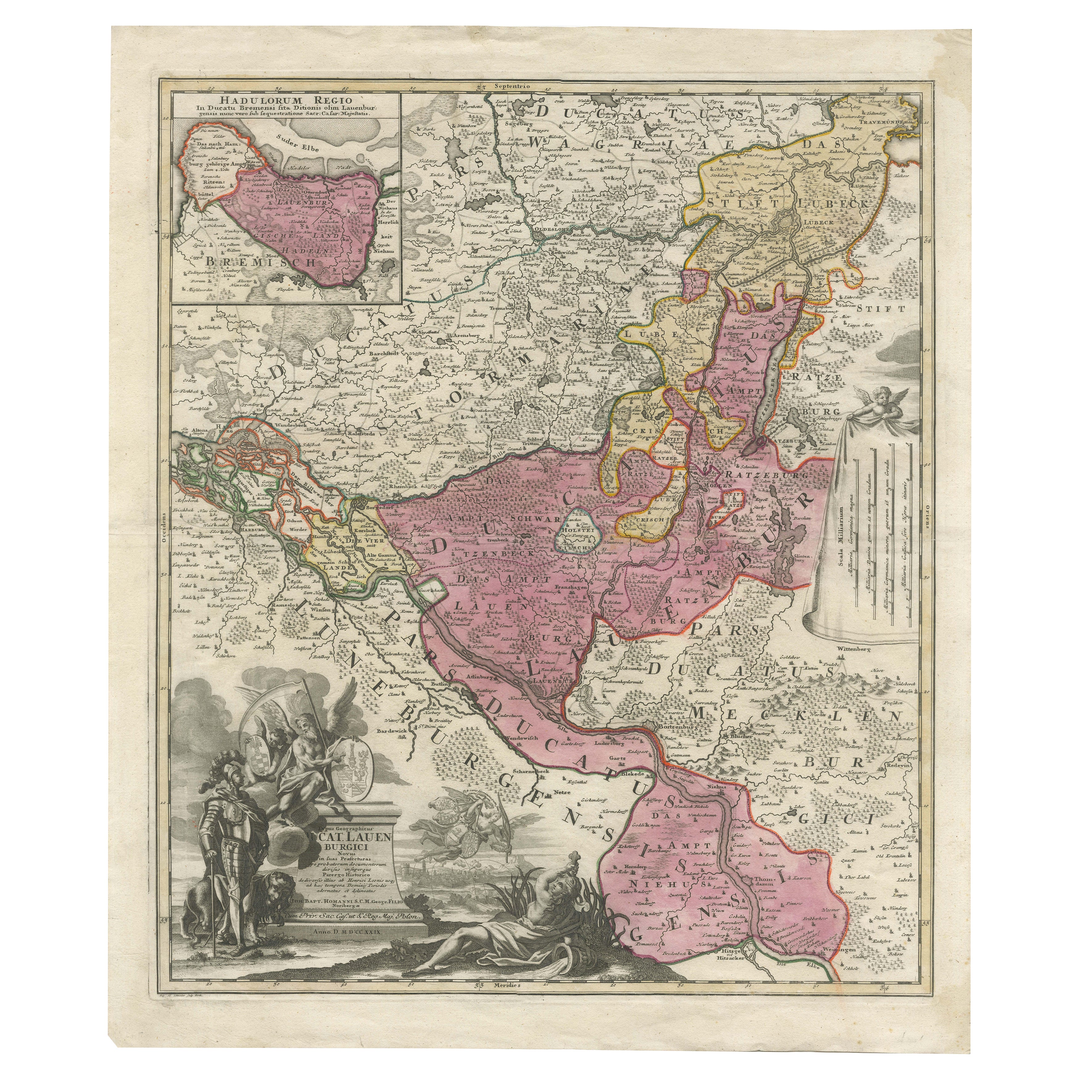
Historical Map of the Duchy of Lauenburg by Johann Baptist Homann - Circa 1720
Located in Langweer, NL
Historical Map of the Duchy of Lauenburg by Johann Baptist Homann - Circa 1720
This splendid historical map titled Ducatus Lauemburgicus is a highly detailed and beautifully engra...
Category
Antique 1720s Maps
Materials
Paper
$516 Sale Price
20% Off
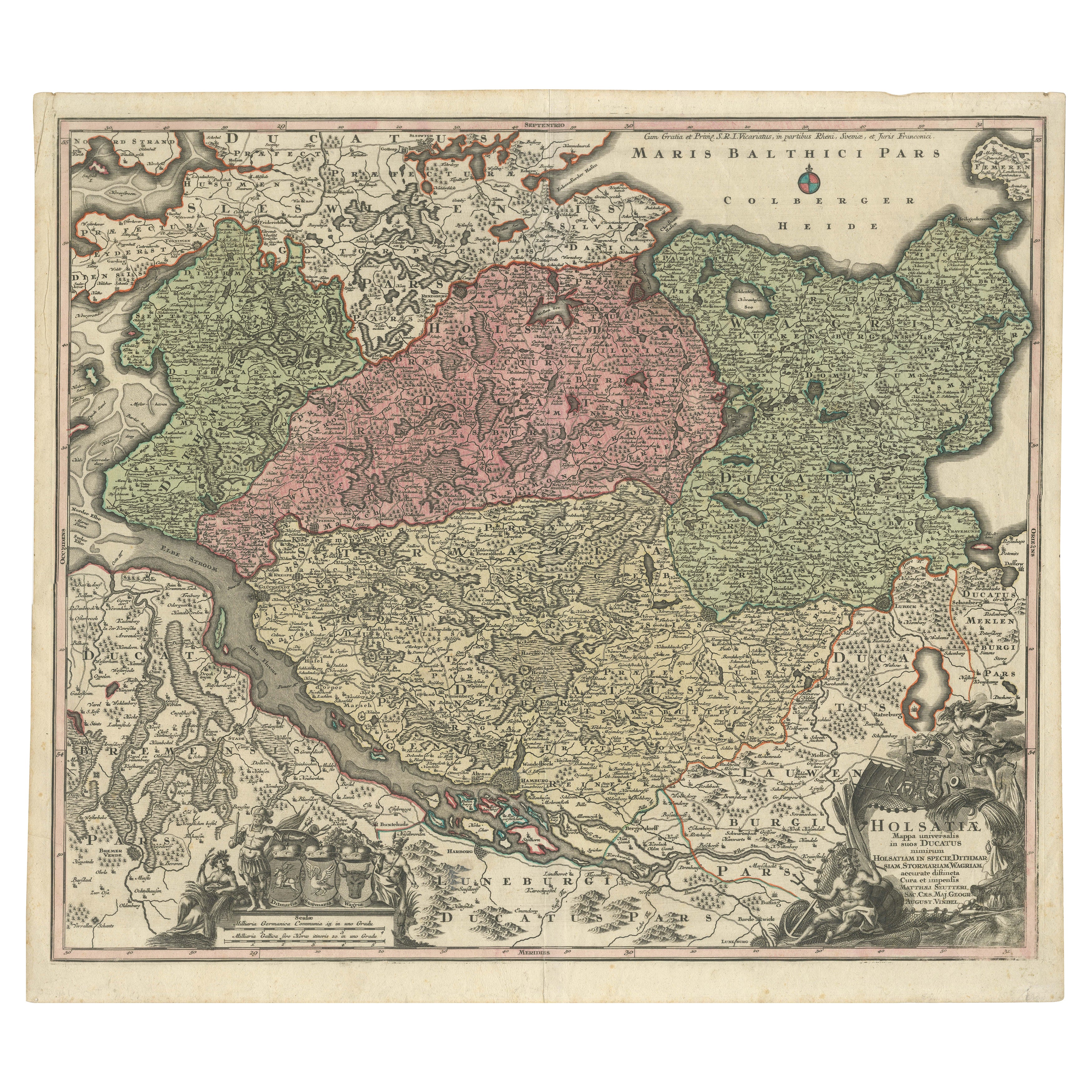
Historical Map of Holstein - Copperplate Engraving by Matthias Seutter, ca. 1730
Located in Langweer, NL
Historical Map of Holstein - Copperplate Engraving by Matthias Seutter, ca. 1730
This impressive historical map, titled Holsatiae. Mappa universalis in suos ducatus nimirum Holsat...
Category
Antique 1730s Maps
Materials
Paper
$516 Sale Price
20% Off
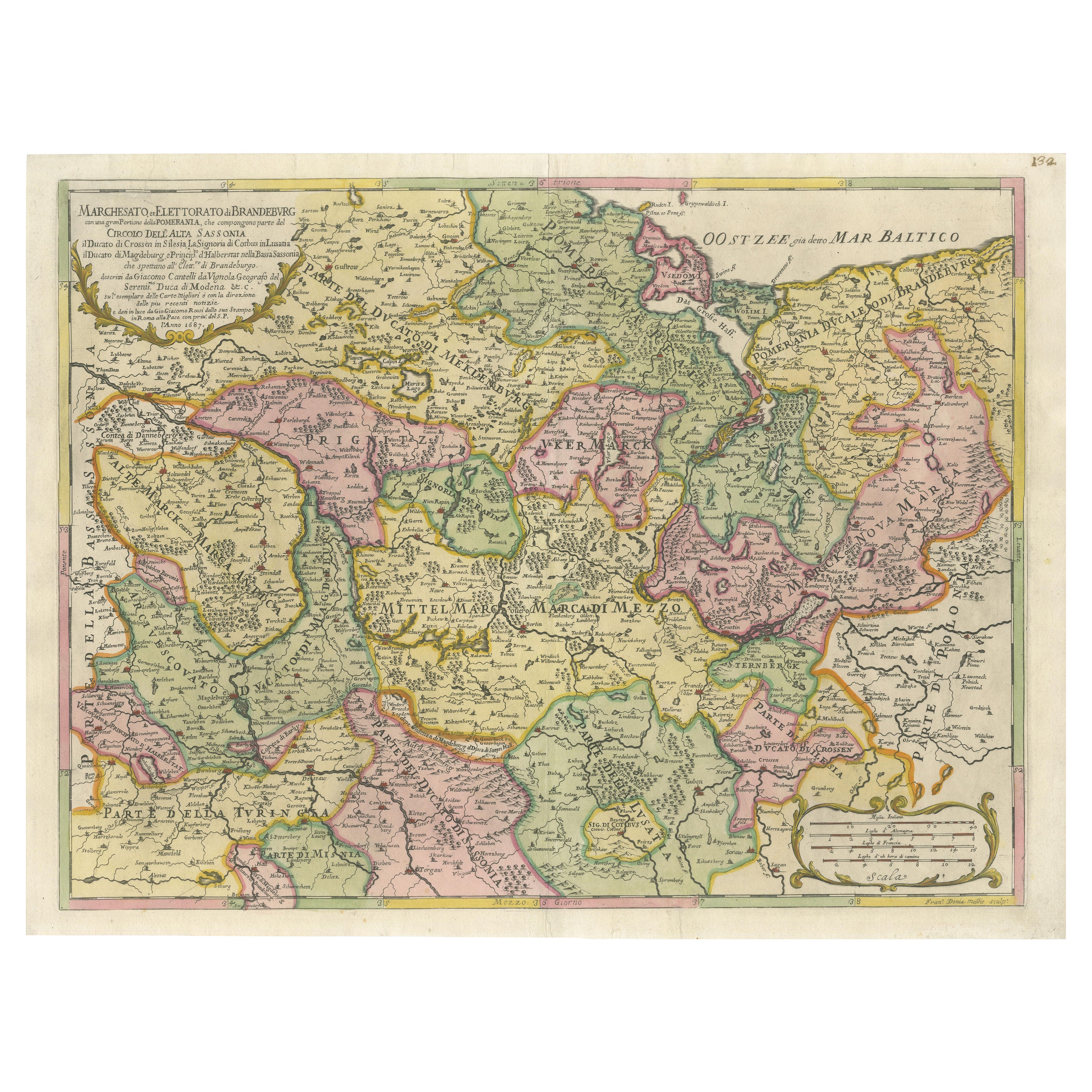
Old Map of the Margraviate of Brandenburg by Giacomo Cantelli da Vignola, 1687
Located in Langweer, NL
Historical Map of the Margraviate of Brandenburg by Giacomo Cantelli da Vignola - 1687
This magnificent map, titled Marchesato, et Elettorato di Brandeburgo con una gran Porzione ...
Category
Antique 1680s Maps
Materials
Paper

$516 Sale Price
20% Off
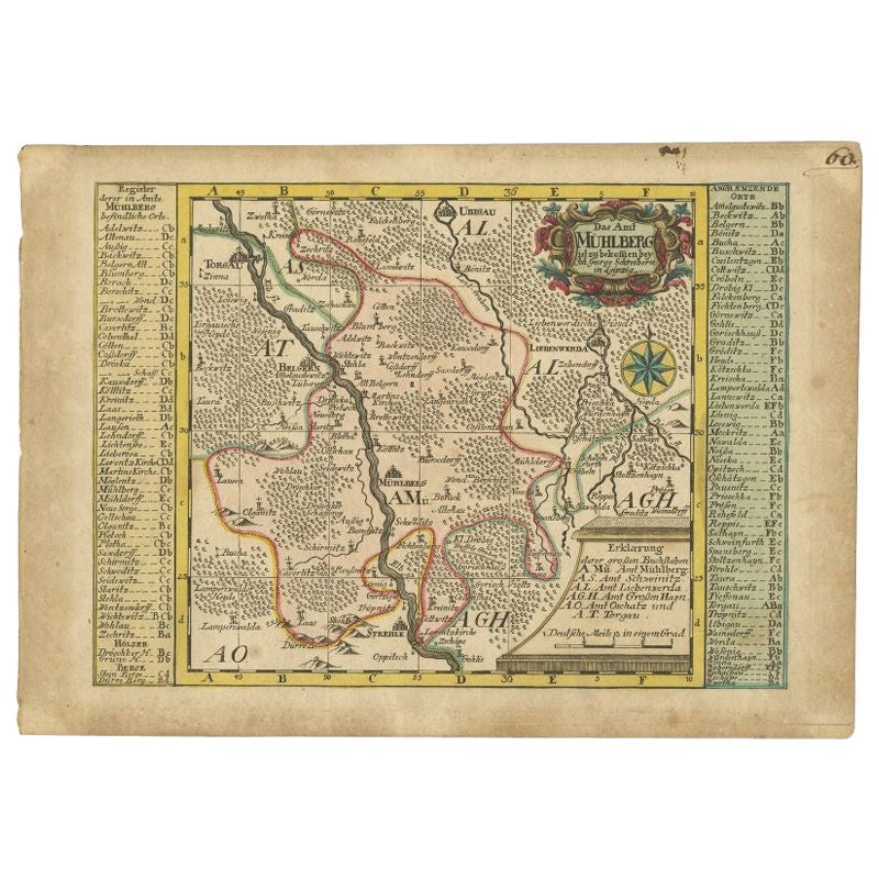
Antique Map of the Region of Mühlberg by Schreiber, 1749
Located in Langweer, NL
Antique map titled 'Das Amt Muhlberg'. Map of the region of Mühlberg, Germany. This map originates from 'Atlas Selectus von allen Konigreichen und Landern de...
Category
Antique 18th Century Maps
Materials
Paper
$89 Sale Price
20% Off
You May Also Like
1790 Thomas Stackhouse Map, Entitled "Russia in Europe, " , Ric.a004
Located in Norton, MA
1790 Thomas Stackhouse map, entitled
"Russia in Europe"
Ric.a004
Stackhouse, Thomas
Russia in Europe [map]
London: T. Stackhouse, 1783. Map. Matted hand-colored copper engraving. Image size: 14.5 x 15.25 inches. Mat size: 22.75 x 23.75 inches. A beautiful example of this map of Eastern Europe...
Category
Antique 17th Century Unknown Maps
Materials
Paper

1657 Janssonius Map of Vermandois and Cappelle, Ric. A-004
Located in Norton, MA
1657 Janssonius map of
Vermandois and Cappelle
Ric.a004
Description: Antique map of France titled 'Descriptio Veromanduorum - Gouvernement de la Cappelle'. Two detailed maps o...
Category
Antique 17th Century Unknown Maps
Materials
Paper

1752 Vaugoundy Map of Flanders : Belgium, France, and the Netherlands, Ric.a002
Located in Norton, MA
Large Vaugoundy Map of Flanders:
Belgium, France, and the Netherlands
Colored -1752
Ric.a002
Description: This is a 1752 Didier Robert de Vaugondy map of Flanders. The map de...
Category
Antique 17th Century Unknown Maps
Materials
Paper

1640 Joan Bleau Map Entitled"Diocecese de rheims et le pais de rethel, " Eic.a011
Located in Norton, MA
1640 Joan Bleau map entitled
"Diocecese de rheims et le pais de rethel,"
Ric.a011
OAN BLAEU
Diocecese de Rheims, et le pais de Rethel.
Handcolored engraving, c.1640.
...
Category
Antique 17th Century Dutch Maps
Materials
Paper

Original Antique Map of Switzerland, Engraved By Barlow, Dated 1807
Located in St Annes, Lancashire
Great map of Switzerland
Copper-plate engraving by Barlow
Published by Brightly & Kinnersly, Bungay, Suffolk.
Dated 1807
Unframed.
Category
Antique Early 1800s English Maps
Materials
Paper

1635 Willem Blaeu Map of Northern France"Comitatvs Bellovacvm" Ric.a08
Located in Norton, MA
1635 Willem Blaeu map of northern France, entitled.
"Comitatvs Bellovacvm Vernacule Beavvais,"
Colored
Ric.a008
“COMITATVS BELLOVACVM…” Amsterdam: W...
Category
Antique 17th Century Unknown Maps
Materials
Paper

More Ways To Browse
18th Century Wood Side Tables
Antique Hand Carved Dining Room Sets
Mid Century Modern Pitcher
Vintage Italian Leather Dining Chair
Vintage Movie Posters
Blue Green Wool And Silk Rug
Brown Sheepskin Chair
Vintage Brass Bar Carts
Antique Botanical Prints
Green Persian Rug
17th Century Blue And White
50 X 50 Coffee Table
Antique Wood Panel Painted
Milo Baughman 1970
Spanish Baroque Furniture
Stone China
Couch Console
Vintage Burn