Central American Maps
to
1
1
1
1
1
1
1
1
1,150
716
331
217
146
1
1
1
Place of Origin: Central American
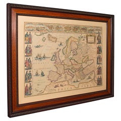
Vintage Reproduction 17th Century Map of Europe, American, Cartography, Blaeuw
Located in Hele, Devon, GB
This is a vintage reproduction map of Europe. An American, paper stock cartography print in frame after the work by Blaeuw, dating to the late 20t...
Category
Late 20th Century Mid-Century Modern Central American Maps
Materials
Glass, Wood, Paper
Related Items
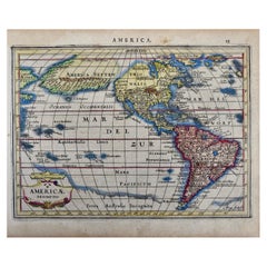
North & South America: A 17th Century Hand-colored Map by Jansson & Goos
By Johannes Janssonius
Located in Alamo, CA
A 17th century hand-colored map of North & South America entitled "Americae Descriptio" by the cartographer Johannes Jansson, published in Jansson's Atlas Minor in Amsterdam in 1628....
Category
1620s Antique Central American Maps
Materials
Paper
$1,275
H 7 in W 8.63 in D 0.07 in
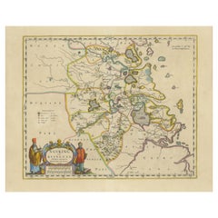
Original 17th-Century Antique Map of Nanjing Province, China – by Blaeu
Located in Langweer, NL
Title: 17th-Century Antique Map of Nanjing Province, China – "Nanking sive Kiangnan" by Blaeu, with Decorative Details
Description: This captivating 17th-century map of Nanjing Pr...
Category
1650s Antique Central American Maps
Materials
Paper
$1,606
H 18.9 in W 23.04 in D 0.01 in
Rare 17th Century South American Shrine
Located in Rio De Janeiro, BR
Rare 17th Century Cedar Shrine.
Straight box with padded doors. Interior with decorative arch in the shape of a portal.
Dimensions in centimeters: 52cm W x 26,50 cm D x 71 cm H.
Th...
Category
Late 17th Century Baroque Antique Central American Maps
Materials
Cedar
Rare 17th Century South American Colonial Shrine
Located in Rio De Janeiro, BR
Rare 17th Century South American Colonial Shrine
Straight box with pediment cut into stylized volutes. Made of polished cedar, with wrought iron fittings, this oratory reflects the ...
Category
Late 17th Century Baroque Antique Central American Maps
Materials
Cedar
Large 17th-Century Coronelli Map of Europe with Mythical Islands and Rich Detail
Located in Langweer, NL
Large 17th-Century Coronelli Map of Europe with Mythical Islands and Rich Detail
This exceptional two-sheet map of Europe by Vincenzo Maria Coronelli, published in Venice in 1692,...
Category
1690s Antique Central American Maps
Materials
Paper
$3,477
H 26.97 in W 36.62 in D 0.01 in
17th Century Cartographic Marvel: A Detailed Engraving of Guangzhou (Kanton)
Located in Langweer, NL
This engraving of Guangzhou ("Kanton") is from a French edition of Olfert Dapper's work. The French edition titled "Description de l’Empire de la Chine" was published in 1674. It is ...
Category
1670s Antique Central American Maps
Materials
Paper
$1,055 Sale Price
20% Off
H 12.01 in W 15.52 in D 0.01 in
Hand Colored 17th Century Visscher Map "Hollandiae" Southern Holland
By Nicolaes Visscher II
Located in Alamo, CA
A hand colored 17th century map of the southern portions of Holland by Nicolaus (Nicolas) Visscher II entitled "Hollandiae pars Meridionalis, vulgo Zuyd-Holland", published in Amsterdam in 1678. The map shows the region between Breda, Heusden, Gornichem, Gouda, Dordrecht, and Willemstad. It includes a decorative cartouche in the lower left corner.
The map is presented in an attractive maple colored wood frame with gold trim and a fabric mat.
The Visscher family were one of the great cartographic families of the 17th century. Begun by Claes Jansz Visscher...
Category
Early 18th Century Antique Central American Maps
Materials
Paper
$1,275
H 26.63 in W 30.13 in D 0.88 in
17th-Century Antique Map of Jiangxi (Kiangsi) Province, China – by Blaeu
Located in Langweer, NL
Title: 17th-Century Antique Map of Jiangxi Province, China – "Kiangsi" by Blaeu, Detailed and Vibrantly Colored
Description: This detailed 17th-century map of Jiangxi Province, historically referred to as "Kiangsi," was created by Johannes Blaeu and published in 1655 as part of the *Novus Atlas Sinensis*. Jiangxi, located in southeastern China, is known for its cultural heritage, scenic landscapes, and significant contributions to Chinese history.
The map meticulously charts Jiangxi’s geography, including mountain ranges, rivers, and cities, with place names rendered in Latin. Poyang Lake, one of the largest freshwater lakes in China, is prominently depicted, emphasizing the region’s ecological and economic importance. The map also highlights key cities such as Nanchang, the provincial capital, which has long been a cultural and political center, and Jingdezhen, globally famous as the center of Chinese porcelain production.
The decorative cartouche in the lower-right corner features traditional Chinese figures, adding cultural depth to the map. Blaeu’s craftsmanship is evident in the precise copperplate engraving and the vibrant hand-coloring, which enhances the boundaries and natural features, making this map both a functional document and a work of art.
Condition: Nearly excellent. Sharp impression with vivid hand-coloring. Wide margins with minor age-toning appropriate for its age.
Framing Tips: Use a neutral double mat and an ornate gilt or dark wood frame to highlight the map’s historical and artistic value. UV-protective glass is recommended to preserve the hand-coloring and intricate details.
Jiangxi, historically referred to as "Kiangsi," is famous for its rich cultural history, stunning landscapes, and economic contributions. It has been a key region for porcelain production, with Jingdezhen renowned as the "Porcelain Capital" of the world. Poyang Lake, featured prominently on the map, is vital for fishing, transportation, and its ecological significance. The province’s location along the Gan River has historically made it an important transportation corridor. Nanchang, the provincial capital, is noted for its historical landmarks and political significance in modern Chinese history.
Keywords include: antique map of Jiangxi, Kiangsi map, Poyang Lake, Jingdezhen porcelain, 17th-century China map...
Category
1650s Antique Central American Maps
Materials
Paper
$1,606
H 18.9 in W 23.04 in D 0.01 in
"Africa Vetus": a 17th Century Hand-Colored Map by Sanson
By Nicolas Sanson
Located in Alamo, CA
This original hand-colored copperplate engraved map of Africa entitled "Africa Vetus, Nicolai Sanson Christianiss Galliar Regis Geographi" was originally created by Nicholas Sanson d...
Category
Late 17th Century Antique Central American Maps
Materials
Paper
OriginaAntique 17th-Century Map of Guizhou Province, China – (Qveichev) by Blaeu
Located in Langweer, NL
Title: Antique 17th-Century Map of Guizhou Province, China – "Qveichev" by Blaeu, Richly Illustrated and Colored
Description: This remarkable map of Guizhou Province, historically known as "Qveichev," was created by Johannes Blaeu and published in 1655 as part of his *Novus Atlas Sinensis*. This atlas, developed in collaboration with Jesuit missionary Martino Martini, marked the first Western attempt at a comprehensive geographic representation of China. Blaeu’s map offers a detailed depiction of the mountainous terrain, rivers, and towns of Guizhou, a province known for its rugged beauty and cultural diversity.
The map is adorned with two decorative cartouches, each reflecting the artistic and cultural influences of the time. The title cartouche in the lower-right corner features two figures in traditional Chinese attire, symbolizing the blend of European cartographic mastery and Chinese heritage. The upper-left corner includes a secondary cartouche with an explanatory key, adding a touch of elegance to the map’s functionality. Towns, mountains, and rivers are meticulously labeled in Latin, showcasing Blaeu’s dedication to detail and accuracy.
Crafted using the copperplate engraving technique, this map demonstrates exceptional precision. The hand-coloring enhances its visual appeal, highlighting borders and geographic features with vibrant tones. Blaeu’s work is not only a tool for geographic understanding but also a piece of art that embodies the spirit of exploration during the Dutch Golden Age.
Guizhou Province, historically known as "Qveichev," is renowned for its breathtaking natural landscapes, rich ethnic diversity, and historical significance. As one of China's most mountainous regions, Guizhou is characterized by dramatic karst formations, lush green hills, and cascading waterfalls. The province is also home to a variety of ethnic minority groups, including the Miao, Dong, and Bouyei, whose traditions, colorful costumes, and vibrant festivals make the region culturally significant.
Famous features and important places include Huangguoshu Waterfall, one of Asia's largest and most iconic waterfalls, located near the city of Anshun. Zhijin Cave, a vast karst cave system, is celebrated for its stunning stalactites and stalagmites. Kaili is known as the cultural center of Miao traditions, with picturesque villages and celebrated festivals. Zunyi holds historical importance for the Zunyi Conference, a pivotal event in the Chinese Communist Party's history. Fanjing Mountain, a UNESCO World Heritage Site, stands out for its unique biodiversity and sacred Buddhist sites.
Keywords: antique map of China, Guizhou map, Qveichev, 17th-century China map...
Category
1650s Antique Central American Maps
Materials
Paper
$1,678
H 18.9 in W 23.04 in D 0.01 in
Antique Map of Germany from a 17th Century Pocket Atlas, 1685
Located in Langweer, NL
Antique map titled 'Nova Totius Germaniae descriptio.' Miniature map of Germany, from the pocket atlas 'Introductionis in Universam Geographiam tam Veterem...
Category
17th Century Antique Central American Maps
Materials
Paper
$119 Sale Price
20% Off
H 5.12 in W 5.52 in D 0 in
17th Century John Speed Map of Denbighshire, c.1610
By John Speed
Located in Royal Tunbridge Wells, Kent
Antique early 17th century British very rare and original John Speed, hand coloured map of Denbighshire, dated 1610, by John Sunbury and George Humble. John...
Category
17th Century Antique Central American Maps
Materials
Wood, Paper
Previously Available Items
West-Indies Herman Moll William Paterson Spanish Trade Routes Gold
By Herman Moll
Located in BUNGAY, SUFFOLK
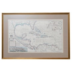
A rare map of the West-Indies or the islands of America in the North Sea with ye adjacent countries explaining what belongs to Spain, England, France, Holland &c also ye Trade Winds and ye several Tracts made by ye Galeons and flota from place to place.
Wil Paterson this map of the West-Indies is most humbly dedicated by Her. Moll geographer.
According to ye newest and most exact observations by Herman Moll Geographer.
Map of the Caribbean islands including southern North America, Mexico, Central America, and northern South America.
Inset at lower left: The City of Mexico in New Spain. Derived from a view in an unpublished atlas by Johannes Vingboons 1628. This image was probably copied from a map by Juan Gomez de Trasmonte, supervisor of the construction of a drainage system for Mexico city in 1628. Kagan, Urban images of the Hispanic world, fig. 4.23
Insets at upper right: La Vera Cruz; A Draught of the Bay and Citty of Havana Cuba; The Bay of Porto Bella; A Draught of ye Citty of Cartagena; A Draught of St. Augustin Saint Augustine, Florida.
Artist : Herman Moll d. 1732.
Bibliography : A new and compleat atlas, London, 1708-1720 Hermand Moll.
Provenance: Private collection.
In a buff mount and gilded frame with green highlight. Maps are generally framed in insigificant frames so that the attention is soley on the map. This map could easily be reframed depending on how and where it will be hung and there are many different choices.
Frame size height 56 cm., 22" length 84 cm., 33".
This is a map that reveals Moll both as an astute political observer and thinker, and tactian. This map of the West Indies is full of commercially sensitive information about the Spanish gold runs, and it is entirely feasible that the map was deliberately suited as a guide to English piracy and privateering in the West Indies. Through his London connections, Moll knew of two prominent English pirates or privateers: Woodes Rogers and William Dampier...
Category
18th Century Baroque Antique Central American Maps
Materials
Paper


