Items Similar to Original 1882 Map of Arabia, Red Sea & Persian Gulf


Want more images or videos?
Request additional images or videos from the seller
1 of 6
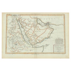
Original 1882 Map of Arabia, Red Sea & Persian Gulf
$335.77
$419.7120% Off
£249.78
£312.2220% Off
€280
€35020% Off
CA$459.78
CA$574.7320% Off
A$511.22
A$639.0220% Off
CHF 266.93
CHF 333.6620% Off
MX$6,222.76
MX$7,778.4520% Off
NOK 3,405.90
NOK 4,257.3820% Off
SEK 3,191.17
SEK 3,988.9620% Off
DKK 2,131.49
DKK 2,664.3620% Off
Shipping
Retrieving quote...The 1stDibs Promise:
Authenticity Guarantee,
Money-Back Guarantee,
24-Hour Cancellation
About the Item
This print is a historically significant map titled "Arabia, the Red Sea, and the Persian Gulf," originally published in 1882 as part of the 'Comprehensive Atlas and Geography of the World.'
The map is characterized by its meticulous detail and the fineness of its engravings, indicative of the high cartographic standards of the late 19th century. It showcases the Arabian Peninsula with geographical features such as mountain ranges, river beds, and desert expanses meticulously plotted. Borders of the time are demarcated in colored outlines, highlighting the territorial divisions known to the world at that time.
Important cities and ports are marked, reflecting the trade routes and strategic locations that were significant for navigation and commerce. The map includes nautical lines indicating sea depths and shipping lanes in the Red Sea and Persian Gulf, emphasizing their importance in global maritime routes. The cartouche in the lower-left corner is elegantly styled, bearing the title in a classic typeface that adds to the antique charm of the piece.
The map's grid lines for latitude and longitude provide a precise framework for the period's navigation and exploration. It is printed on paper that has since aged to a warm tone, with the color palette consisting of subtle yet distinct earth tones for landmasses and a gradient of blues for bodies of water, enhancing its aesthetic and functional value. This map not only serves as a geographical reference but also as a historical artifact, offering insights into the knowledge and perspectives of its time.
- Dimensions:Height: 14.97 in (38 cm)Width: 22.45 in (57 cm)Depth: 0 in (0.02 mm)
- Materials and Techniques:
- Period:
- Date of Manufacture:1882
- Condition:Good condition, folding line in the middle. The outer borders are slightly discolored due to age, but not the image. This map is ideal for framing. Study the image carefully.
- Seller Location:Langweer, NL
- Reference Number:Seller: BG-13601-2-441stDibs: LU3054337695802
About the Seller
5.0
Recognized Seller
These prestigious sellers are industry leaders and represent the highest echelon for item quality and design.
Platinum Seller
Premium sellers with a 4.7+ rating and 24-hour response times
Established in 2009
1stDibs seller since 2017
2,510 sales on 1stDibs
Typical response time: <1 hour
- ShippingRetrieving quote...Shipping from: Langweer, Netherlands
- Return Policy
Authenticity Guarantee
In the unlikely event there’s an issue with an item’s authenticity, contact us within 1 year for a full refund. DetailsMoney-Back Guarantee
If your item is not as described, is damaged in transit, or does not arrive, contact us within 7 days for a full refund. Details24-Hour Cancellation
You have a 24-hour grace period in which to reconsider your purchase, with no questions asked.Vetted Professional Sellers
Our world-class sellers must adhere to strict standards for service and quality, maintaining the integrity of our listings.Price-Match Guarantee
If you find that a seller listed the same item for a lower price elsewhere, we’ll match it.Trusted Global Delivery
Our best-in-class carrier network provides specialized shipping options worldwide, including custom delivery.More From This Seller
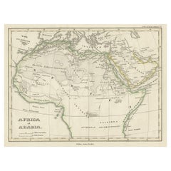
View AllOld Map of the Arabian Peninsula with Parts of Egypt, Sudan, Eritrea & Ethiopia
Located in Langweer, NL
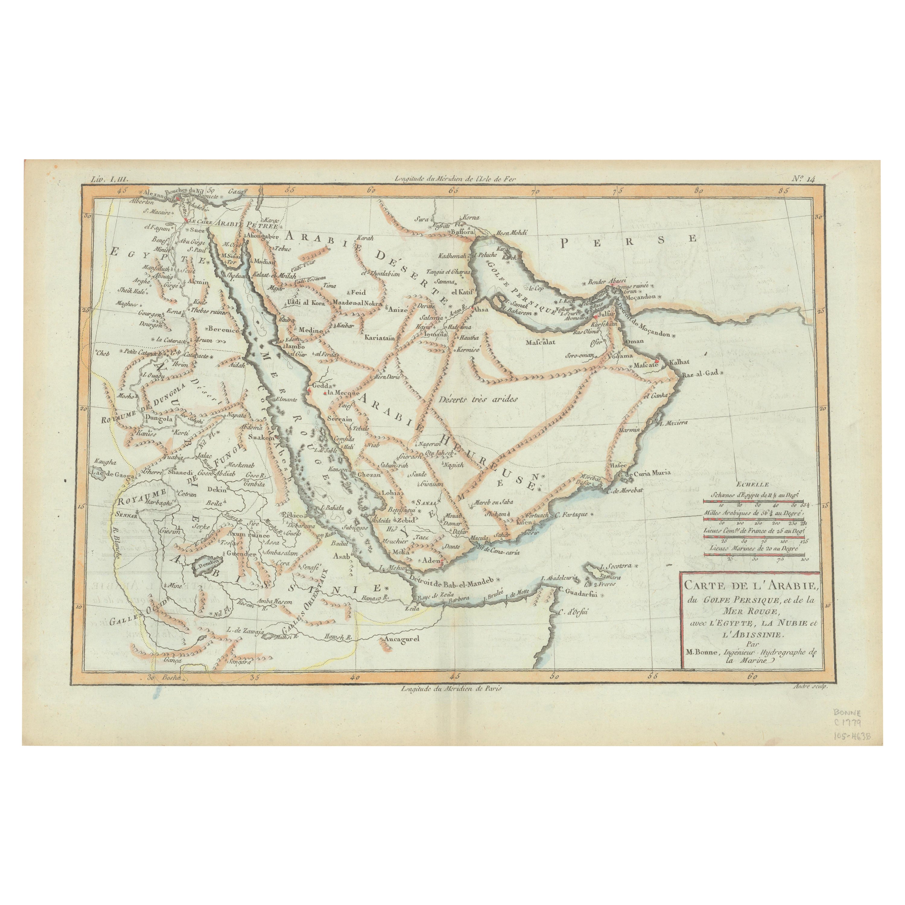
"Carte de l'Arabie, du Golfe Persique, et de la Mer Rouge, avec l'Egypte, la Nubie et l'Abissinie", Bonne, Rigobert
Subject: Arabia
Period: 1780 (circa)
Publication: Atlas de Toutes...
Category
Antique 1780s Maps
Materials
Paper
$364 Sale Price
20% Off
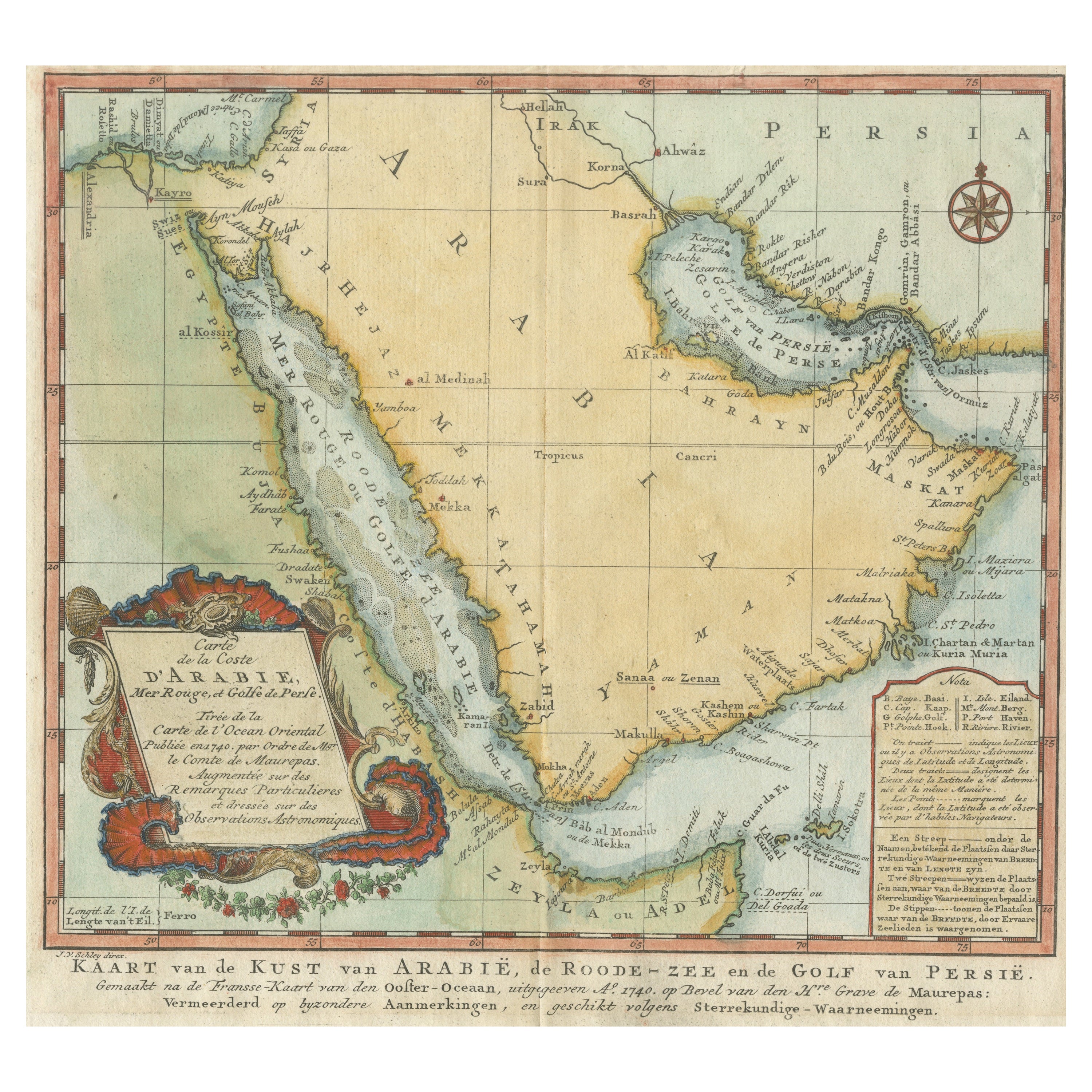
Original Antique Map of Arabia and the Red Sea
Located in Langweer, NL
Antique map titled 'Carte de la Coste d'Arabie (..) - Kaart van de Kust van Arabië (..)'. This is a Dutch version, engraved by J. van Schley, of Bellin's map of Arabia and the Red Sea...
Category
Antique Mid-18th Century Maps
Materials
Paper

$450 Sale Price
20% Off
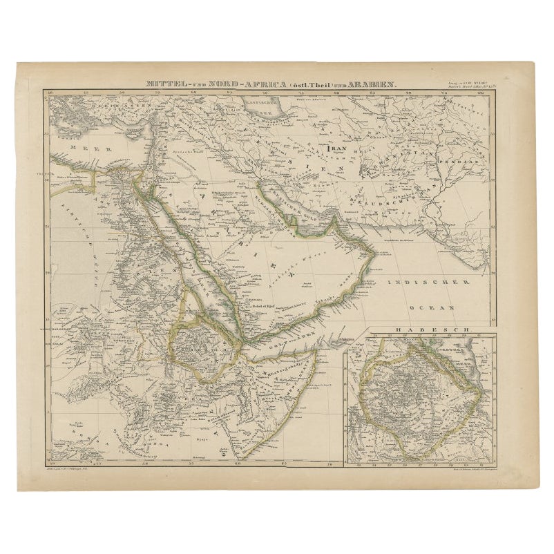
Antique Map of Africa and Arabia with Inset Map of Ethiopia and Eritrea, 1845
Located in Langweer, NL
Antique map titled 'Mittel- und Nord-Africa (östl. Theil) und Arabien'. This map depicts North and Central Africa and Arabia with an inset map of Habesch (Ethiopia and Eritrea).
Ar...
Category
Antique 19th Century Maps
Materials
Paper
$211 Sale Price
20% Off
Antique Map of the Arabian Peninsula by Bonne 'c.1780'
Located in Langweer, NL
Antique map titled 'Carte de l'Arabie, du Golfe Persique, et de la Mer Rouge (..)'. Original antique map of the Arabian Peninsula, including the horn...
Category
Antique Late 18th Century Maps
Materials
Paper

$527 Sale Price
20% Off
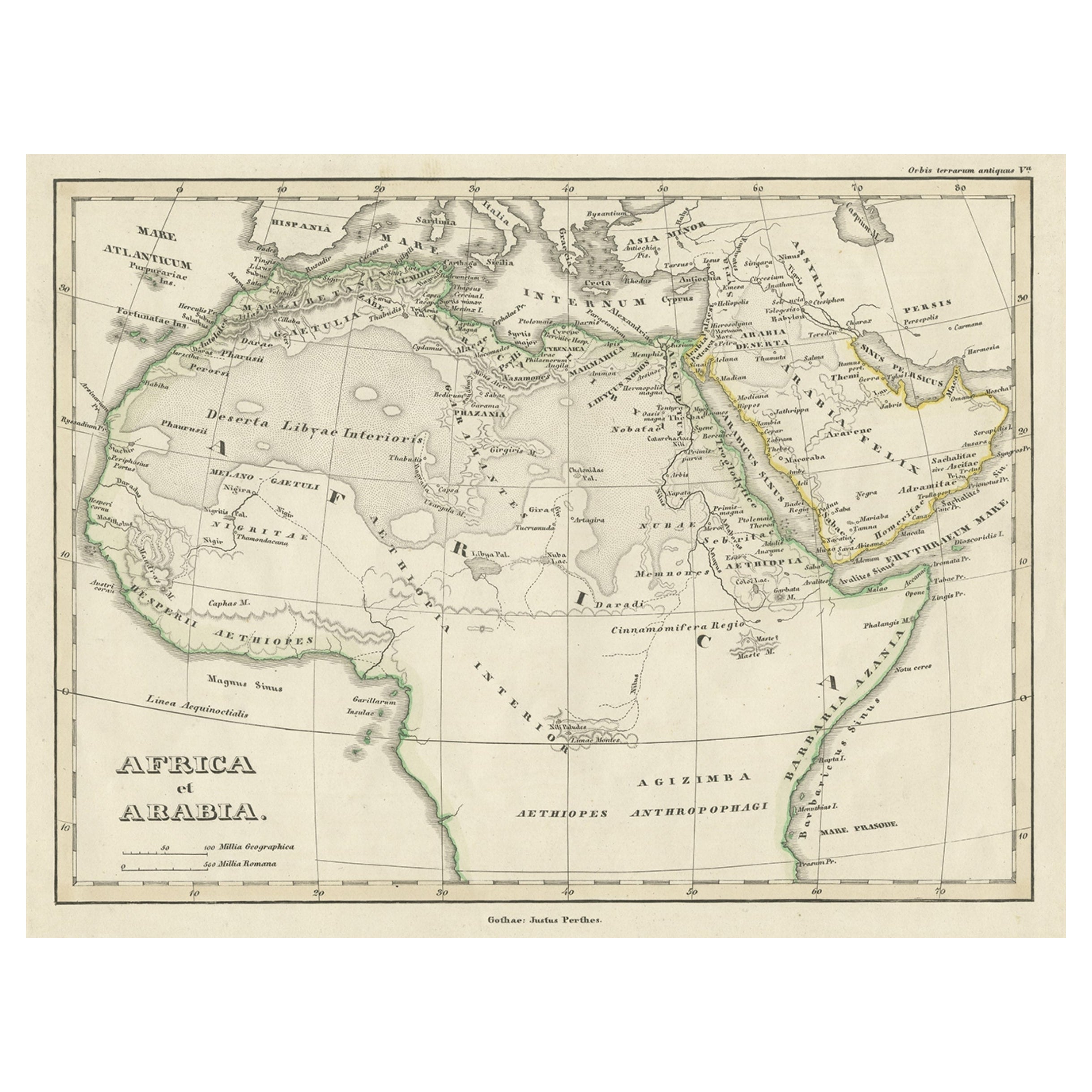
Old Original Map of Africa and Arabia, 1848
Located in Langweer, NL
Antique map titled 'Africa et Arabia'.
Old map of Africa and Arabia originating from 'Orbis Terrarum Antiquus in usum Scholarum'.
Artists and Engravers: Published by Justus P...
Category
Antique 1840s Maps
Materials
Paper
$124 Sale Price
20% Off
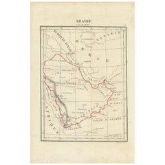
Antique Map of Arabia by Tardieu '1843'
Located in Langweer, NL
Antique map titled 'Arabie'. Attractive small map of Arabia. This map originates from 'Dictionnaire Universel de Geographie Moderne' 4th Edition, by A.Pe...
Category
Antique Mid-19th Century Maps
Materials
Paper
$191 Sale Price
20% Off
You May Also Like
Large Original Antique Map of Morocco. Edward Weller, 1861
Located in St Annes, Lancashire
Great map of Morocco
Lithograph engraving by Edward Weller
Original colour
Published, 1861
Unframed
Good condition.
Category
Antique 1860s English Victorian Maps
Materials
Paper

Persia, Armenia & Adjacent Regions: A 17th Century Hand-colored Map by De Wit
By Frederick de Wit
Located in Alamo, CA
A large 17th century hand colored copperplate engraved map entitled "Novissima nec non Perfectissima Scandinaviae Tabula comprehendens Regnorum Sueciae, Daniae et Norvegiae distincte...
Category
Antique Late 17th Century Dutch Maps
Materials
Paper

Map of the Holy Land "Carte de la Syrie et de l'Egypte" by Pierre M. Lapie
By Pierre M. Lapie
Located in Alamo, CA
An early 19th century map of ancient Syria and Egypt entitled "Carte de la Syrie et de l'Egypte anciennes/dressée par M. Lapie, Colonel d'Etat Major, et...
Category
Antique Early 19th Century French Maps
Materials
Paper

Antique 1803 Italian Map of Asia Including China Indoneseia India
Located in Amsterdam, Noord Holland
Antique 1803 Italian Map of Asia Including China Indoneseia India
Very nice map of Asia. 1803.
Additional information:
Type: Map
Country of Manufacturing: Europe
Period: 19th centu...
Category
Antique 19th Century European Maps
Materials
Paper

$584 Sale Price
20% Off
Large Original Antique Map of Afghanistan. Edward Weller, 1861
Located in St Annes, Lancashire
Great map of Afghanistan
Lithograph engraving by Edward Weller
Original colour
Published, 1861
Unframed
Good condition
Category
Antique 1860s English Victorian Maps
Materials
Paper

Africa. North-East Part. Century Atlas antique vintage map
Located in Melbourne, Victoria
'The Century Atlas. Africa. North-East Part'
Original antique map, 1903.
Inset map of 'Nile Delta and Suez Canal'.
Central fold as issued. Map name and nu...
Category
Early 20th Century Victorian More Prints
Materials
Lithograph

More Ways To Browse
Arabian Antique
Vintage Art Deco Rugs
Vintage Serving Forks
Herati Rug
Italian Wood Console Tables
Maison Jansen Argentina
Antique Oushak
Mid Century Danish Directors Chairs
Moller 70
Wood Relief Art
Argentina Travel Poster
Century Furniture Faux Bamboo
Early American Chairs
Hans Muller
Vintage Wood Table With Glass Top
19th Century Square Table
Antonio Bonet
Galle Chairs