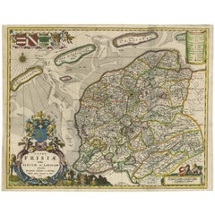
Items Similar to Original Antique Hand-Colored Map of Friesland by C. Merian, 1659

Want more images or videos?
Request additional images or videos from the seller
1 of 10
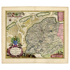
Original Antique Hand-Colored Map of Friesland by C. Merian, 1659
$455.14
£337.28
€380
CA$621.35
A$691.23
CHF 362.35
MX$8,446.67
NOK 4,614.10
SEK 4,343.54
DKK 2,893.29
Shipping
Retrieving quote...The 1stDibs Promise:
Authenticity Guarantee,
Money-Back Guarantee,
24-Hour Cancellation
About the Item
This is a hand-colored engraving of the province of Friesland in the Netherlands, created by the Swiss-born engraver and artist Matthäus Merian (1593–1650) and included in "Topographia Germaniae Inferioris" by Martin Zeiler, published in 1659.
Merian was renowned for his detailed and accurate engravings of cities and landscapes, often with a bird's-eye view perspective, which were highly regarded for their artistry and precision. His works include a vast series of topographical studies and maps known collectively as the "Topographia" series, which documented various regions, cities, and significant sites throughout Europe.
The "Topographia Germaniae Inferioris" is part of this series and covers the Low Countries, which today consist of the Netherlands, Belgium, and Luxembourg. The hand-colored aspect of the map indicates that it was individually painted by hand after printing, which was a common practice to add aesthetic appeal and to clarify and distinguish different features of the map.
Such a map would not only be an important historical document, providing insight into the geography, administrative boundaries, and settlements of Friesland during the mid-17th century but also a work of art. The craftsmanship in the engraving, coupled with the hand coloring, would make it a collectible item for map enthusiasts, those interested in Dutch history, or collectors of antique prints.
If the map is in good condition and the coloring is still vibrant, it could be quite valuable. Collectors and historians prize such maps for their beauty, historical value, and the skill required to produce them. Preservation of such maps typically involves careful handling, framing, and placement away from direct sunlight to prevent fading of the colors.
- Dimensions:Height: 11.74 in (29.8 cm)Width: 14.3 in (36.3 cm)Depth: 0.02 in (0.5 mm)
- Materials and Techniques:
- Period:Mid-17th Century
- Date of Manufacture:1659
- Condition:The map is in good condition and the coloring is still vibrant. Please study image carefully.
- Seller Location:Langweer, NL
- Reference Number:Seller: BG-002361stDibs: LU305438910743
About the Seller
5.0
Recognized Seller
These prestigious sellers are industry leaders and represent the highest echelon for item quality and design.
Platinum Seller
Premium sellers with a 4.7+ rating and 24-hour response times
Established in 2009
1stDibs seller since 2017
2,502 sales on 1stDibs
Typical response time: <1 hour
- ShippingRetrieving quote...Shipping from: Langweer, Netherlands
- Return Policy
Authenticity Guarantee
In the unlikely event there’s an issue with an item’s authenticity, contact us within 1 year for a full refund. DetailsMoney-Back Guarantee
If your item is not as described, is damaged in transit, or does not arrive, contact us within 7 days for a full refund. Details24-Hour Cancellation
You have a 24-hour grace period in which to reconsider your purchase, with no questions asked.Vetted Professional Sellers
Our world-class sellers must adhere to strict standards for service and quality, maintaining the integrity of our listings.Price-Match Guarantee
If you find that a seller listed the same item for a lower price elsewhere, we’ll match it.Trusted Global Delivery
Our best-in-class carrier network provides specialized shipping options worldwide, including custom delivery.More From This Seller
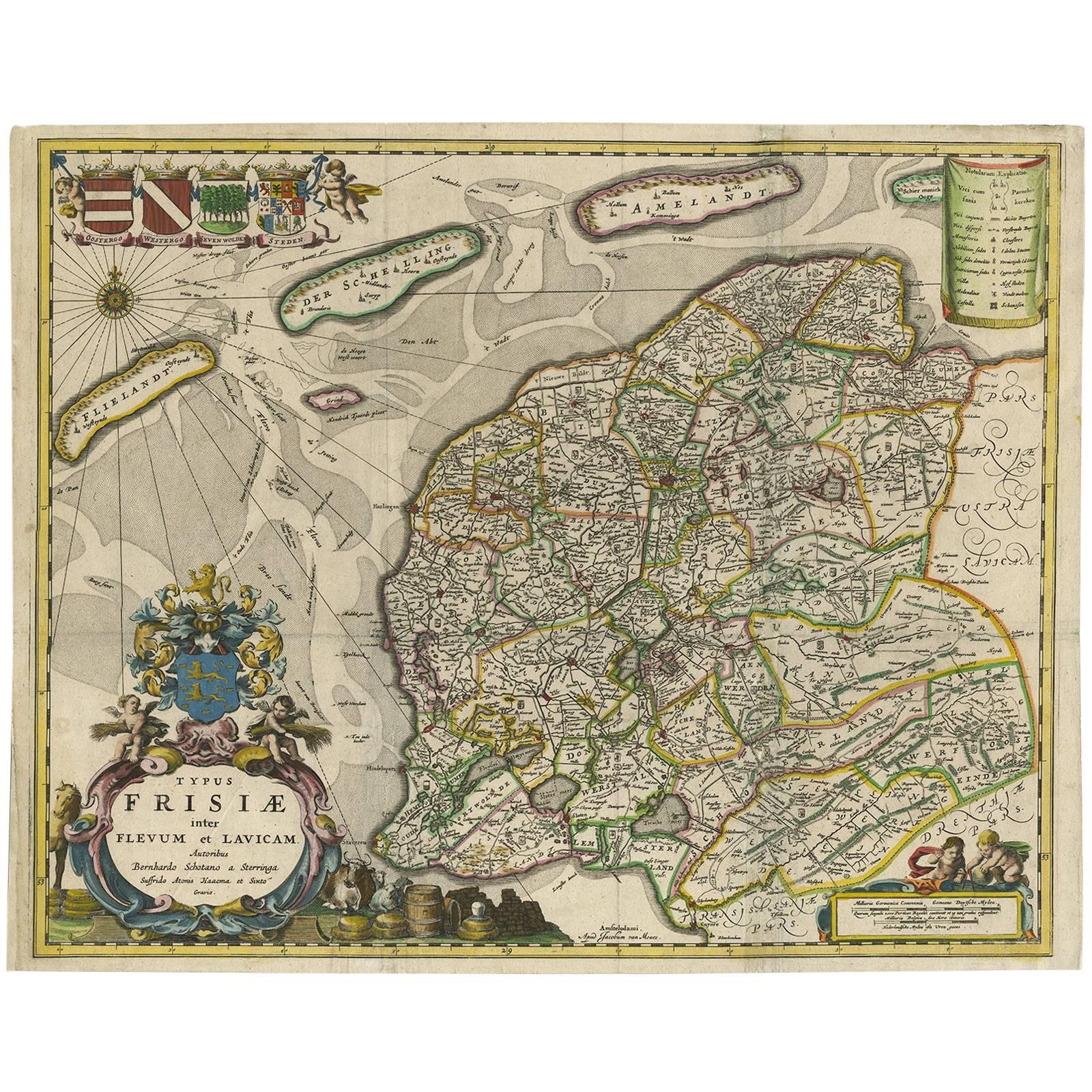
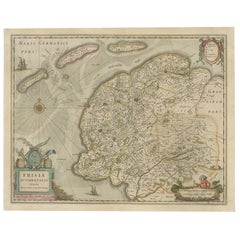
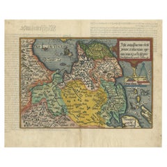
View AllAntique Map of Friesland 'The Netherlands' by B. Schotanus, 1664
By B. Schotanus
Located in Langweer, NL
Hand-colored map of the Dutch province Friesland. Also shows the Wadden islands Vlieland, Terschelling and Ameland and a part of Schiermonnikoog. With a decorative cartouche with two...
Category
Antique Late 17th Century Maps
Materials
Paper
$1,604 Sale Price
9% Off
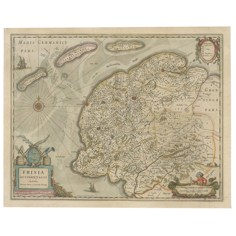
Antique Map of Friesland, The Netherlands, 1638
Located in Langweer, NL
Antique map titled 'Frisia Occidentalis'.
Original antique map of Friesland, the Netherlands. First state, originating from 'Atlantis novi pars secunda' published 1638.
Artis...
Category
Antique 17th Century Maps
Materials
Paper
$455 Sale Price
20% Off
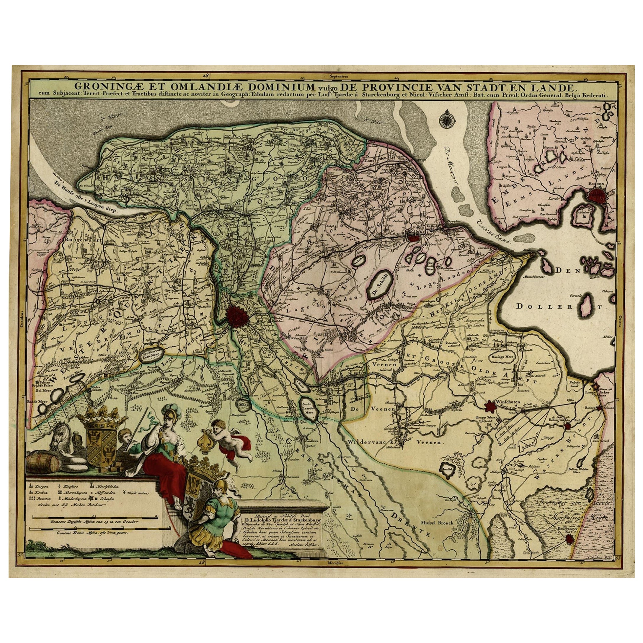
Antique Handcolored Map of the Dutch Province Groningen, Incl. Emden, Ca.1680
Located in Langweer, NL
Antique print, titled: 'Groningae et Omlandiae Dominium vulgo de Pronvicie van Stadt en Lande …'
A map of the Dutch province Groningen. A small part of Germany is also shown (Emd...
Category
Antique 1680s Maps
Materials
Paper
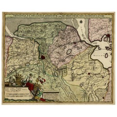
$910 Sale Price
20% Off
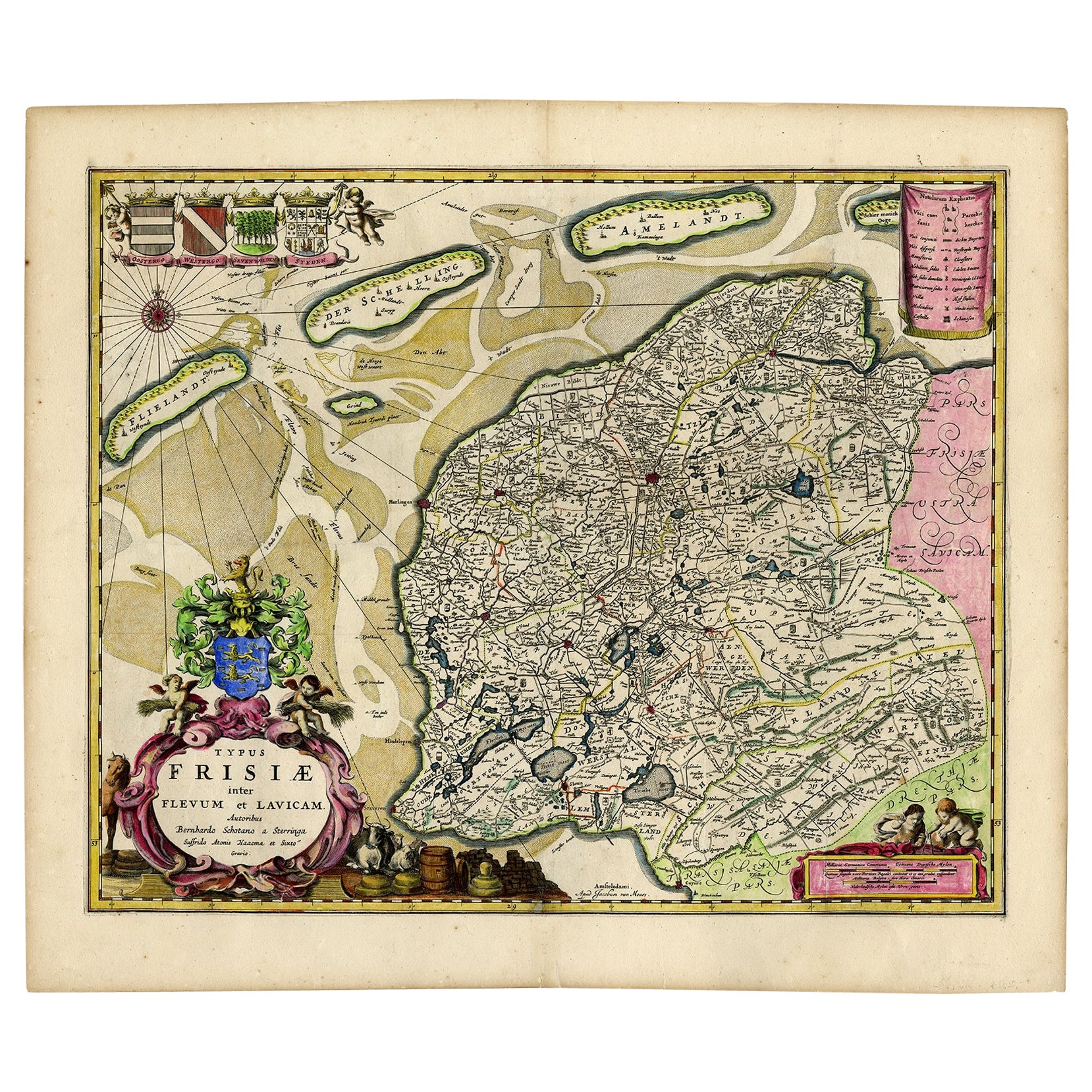
Antique Map of Friesland with Four Coats of Arms, 1664
Located in Langweer, NL
Antique map titled 'Typus Frisiae inter Fevum et Lavicam'. Original antique map of the province of Friesland, the Netherlands. Also shows the Wadden islands Vlieland, Terschelling and Ameland and part of Schiermonnikoog. With a decorative cartouche with two putti, livestock and cheese and milk barrels. Four coats...
Category
Antique 17th Century Maps
Materials
Paper
$1,389 Sale Price
20% Off
Original Antique Map of Friesland in Decorative Hand-Colouring, 1600
Located in Langweer, NL
Antique map titled 'Frisiae antiquissima trans rhenu provinc et adiacentium regionum nova et exacta descriptio'. Original antique map of the province of Friesland, the Netherlands. T...
Category
Antique 17th Century Maps
Materials
Paper
$594 Sale Price
20% Off
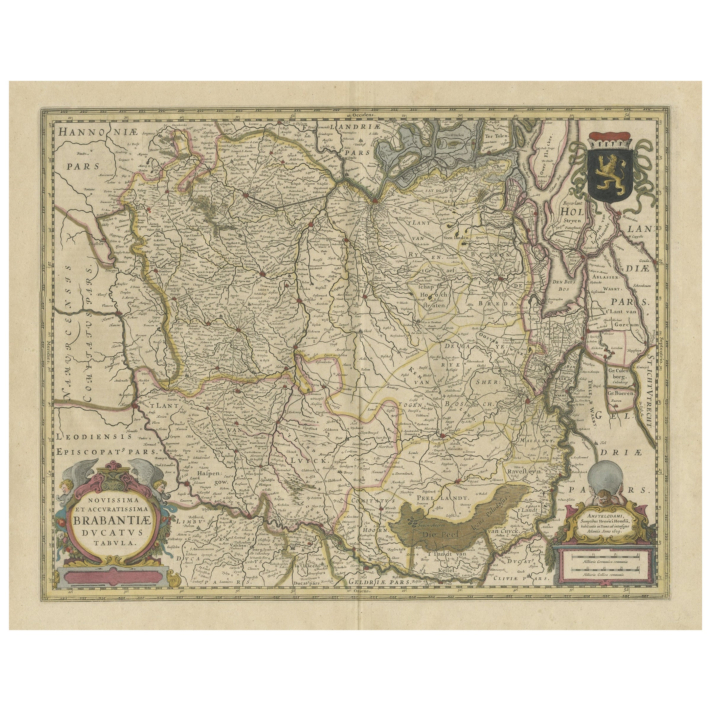
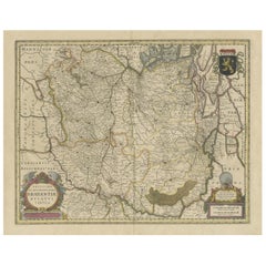
Antique Map of Brabant, the Netherlands, with Original Hand Coloring
Located in Langweer, NL
Original antique map titled 'Novissima et Accuratissima Brabantiae Ducatus Tabula'. Old map of Brabant, the Netherlands. North is to the right. Like all other maps of Brabantiae Duca...
Category
Antique Mid-17th Century Maps
Materials
Paper
$785 Sale Price
20% Off
You May Also Like
17th Century Hand-Colored Map of a Region in West Germany by Janssonius
By Johannes Janssonius
Located in Alamo, CA
This attractive highly detailed 17th century original hand-colored map is entitled "Archiepiscopatus Maghdeburgensis et Anhaltinus Ducatus cum terris adjacentibus". It was published ...
Category
Antique Mid-17th Century Dutch Maps
Materials
Paper

17th Century Hand Colored Map of the Liege Region in Belgium by Visscher
By Nicolaes Visscher II
Located in Alamo, CA
An original 17th century map entitled "Leodiensis Episcopatus in omnes Subjacentes Provincias distincté divisusVisscher, Leodiensis Episcopatus" by Nicolaes Visscher II, published in Amsterdam in 1688. The map is centered on Liege, Belgium, includes the area between Antwerp, Turnhout, Roermond, Cologne, Trier and Dinant.
This attractive map is presented in a cream-colored mat measuring 30" wide x 27.5" high. There is a central fold, as issued. There is minimal spotting in the upper margin and a tiny spot in the right lower margin, which are under the mat. The map is otherwise in excellent condition.
The Visscher family were one of the great cartographic families of the 17th century. Begun by Claes Jansz Visscher...
Category
Antique Late 17th Century Dutch Maps
Materials
Paper

Prussia, Poland, N. Germany, Etc: A Hand-colored 17th Century Map by Janssonius
By Johannes Janssonius
Located in Alamo, CA
This is an attractive hand-colored copperplate engraved 17th century map of Prussia entitled "Prussia Accurate Descripta a Gasparo Henneberg Erlichensi", published in Amsterdam by Joannes Janssonius in 1664. This very detailed map from the golden age of Dutch cartography includes present-day Poland, Latvia, Lithuania, Estonia and portions of Germany. This highly detailed map is embellished by three ornate pink, red, mint green and gold...
Category
Antique Mid-17th Century Dutch Maps
Materials
Paper

West Germany: Original Hand Colored 17th Century Map by Johannes Janssonius
By Johannes Janssonius
Located in Alamo, CA
An original hand colored copperplate engraved map entitled in Latin "Archiepiscopatus Maghdeburgensis et Anhaltinus Ducatus cum terris adjacentibus", published in Amsterdam in 1640 i...
Category
Mid-17th Century Old Masters More Prints
Materials
Engraving

1643 Willem&Joan Blaeu Map NW Flanders "Flandriae Teutonicae Pars Prientalior
Located in Norton, MA
1643 Willem and Joan Blaeu map of northwest Flanders, entitled
"Flandriae Teutonicae Pars Prientalior,"
Ric0012
" Authentic" - Map of the northwest Fl...
Category
Antique 17th Century Dutch Maps
Materials
Paper

1640 Willem Blaeu Map Entitled "Contado di molise et principato vltra, " Ric.a003
By Willem Blaeu
Located in Norton, MA
1640 Willem Blaeu map entitled
"Contado di molise et principato vltra,"
Colored
Ric. a003
Measures: 38 x 49.6 cm and wide margins
DBLAEU.
Cou...
Category
Antique 17th Century Dutch Maps
Materials
Paper

More Ways To Browse
Gold Modern Coffee Table
Large Side Tables
Japanese Silver Ceramics
One Of A Kind Chair
Used Oak Dining Room Chairs
17th Century Plate
Childrens Vintage Poster
Chinese Ship
Vintage Travel Poster Mid Century
Desk Key
Woven Silk Art
Carved Cabriole Table
Dark Antique Table
White Wooden Table
Antique Wall Table
1960 Chair Wood Danish
Unusual Dining Table
Antique Dutch Plates