Items Similar to Original Antique Map of New Brunswick and Nova Scotia, 1889


Want more images or videos?
Request additional images or videos from the seller
1 of 5
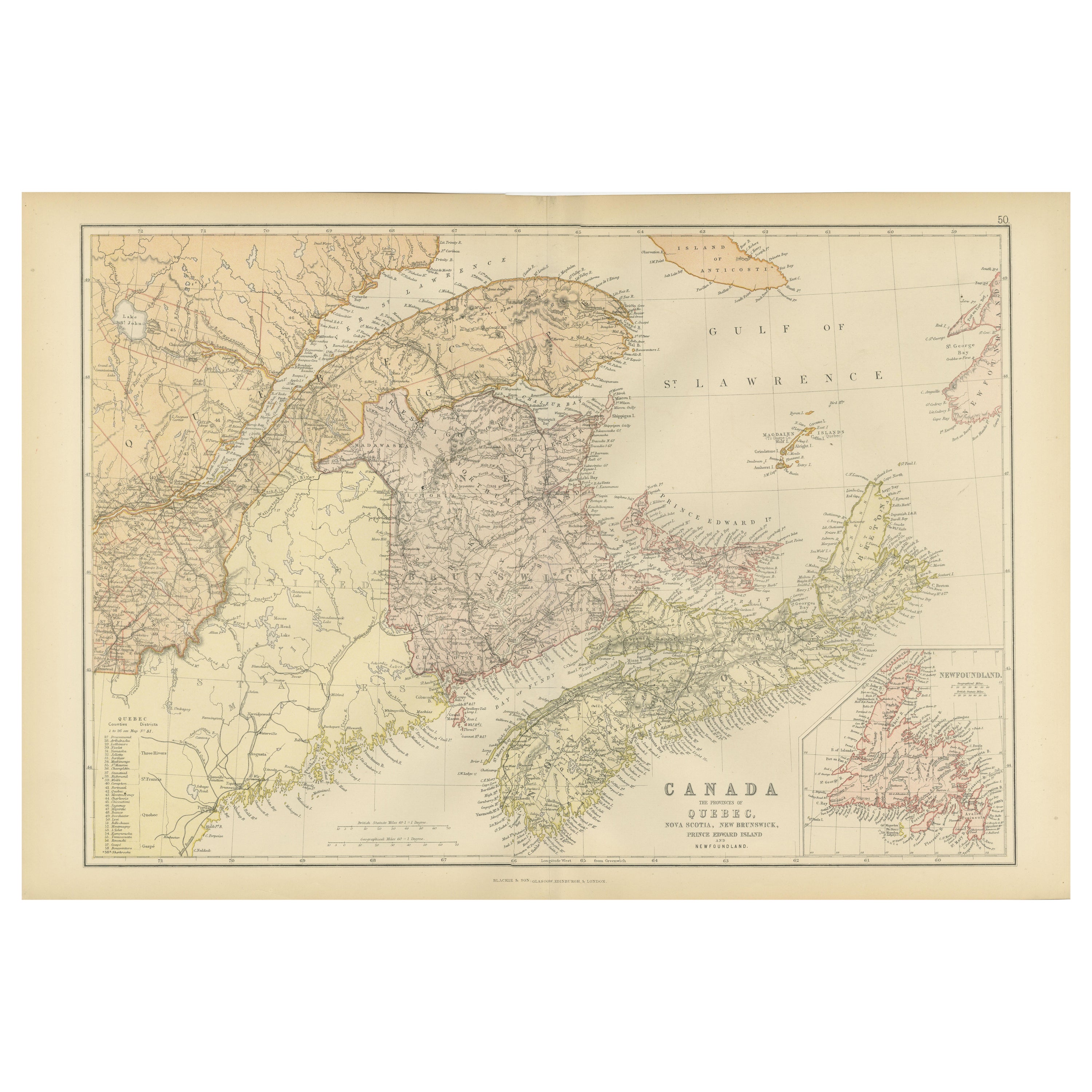
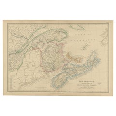
Original Antique Map of New Brunswick and Nova Scotia, 1889
$35
£26.58
€30.39
CA$48.90
A$54.39
CHF 28.40
MX$661.84
NOK 362.70
SEK 340.15
DKK 226.83
Shipping
Retrieving quote...The 1stDibs Promise:
Authenticity Guarantee,
Money-Back Guarantee,
24-Hour Cancellation
About the Item
Great map of New Brunswick and Nova Scotia
Drawn and Engraved by W. & A.K. Johnston
Published By A & C Black, Edinburgh.
Original colour
Unframed.
- Dimensions:Height: 8 in (20.32 cm)Width: 11 in (27.94 cm)Depth: 0.07 in (1.78 mm)
- Style:Victorian (Of the Period)
- Materials and Techniques:Paper,Other
- Place of Origin:
- Period:
- Date of Manufacture:1889
- Condition:Wear consistent with age and use.
- Seller Location:St Annes, GB
- Reference Number:1stDibs: LU1836324967172
About the Seller
4.9
Platinum Seller
Premium sellers with a 4.7+ rating and 24-hour response times
1stDibs seller since 2016
3,114 sales on 1stDibs
Typical response time: 1 hour
Associations
International Confederation of Art and Antique Dealers' Associations
- ShippingRetrieving quote...Shipping from: St Annes, United Kingdom
- Return Policy
Authenticity Guarantee
In the unlikely event there’s an issue with an item’s authenticity, contact us within 1 year for a full refund. DetailsMoney-Back Guarantee
If your item is not as described, is damaged in transit, or does not arrive, contact us within 7 days for a full refund. Details24-Hour Cancellation
You have a 24-hour grace period in which to reconsider your purchase, with no questions asked.Vetted Professional Sellers
Our world-class sellers must adhere to strict standards for service and quality, maintaining the integrity of our listings.Price-Match Guarantee
If you find that a seller listed the same item for a lower price elsewhere, we’ll match it.Trusted Global Delivery
Our best-in-class carrier network provides specialized shipping options worldwide, including custom delivery.More From This Seller
View AllOriginal Antique Map of the American State of Maine, 1903
Located in St Annes, Lancashire
Antique map of Maine
Published By A & C Black. 1903
Original colour
Good condition
Unframed.
Free shipping
Category
Antique Early 1900s English Maps
Materials
Paper

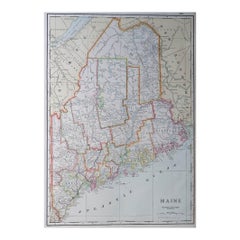
Large Original Antique Map of Maine, USA, C.1900
Located in St Annes, Lancashire
Fabulous map of Maine
Original color
Engraved and printed by the George F. Cram Company, Indianapolis.
Published, C.1900
Unframed
Free shipping.
Category
Antique 1890s American Maps
Materials
Paper
Original Antique Map of the American State of Massachusetts, 1903
Located in St Annes, Lancashire
Antique map of Vermont and New Hampshire
Published By A & C Black. 1903
Original colour
Good condition
Unframed.
Free shipping
Category
Antique Early 1900s English Maps
Materials
Paper

Original Antique Map of the American State of Connecticut & Rhode Island, 1903
Located in St Annes, Lancashire
Antique map of Connecticut and Rhode Island
Published By A & C Black. 1903
Original colour
Good condition
Unframed.
Free shipping
Category
Antique Early 1900s English Maps
Materials
Paper

Original Antique Map of the American State of New York ( Western Part ) 1903
Located in St Annes, Lancashire
Antique map of New York ( Western Part )
Published By A & C Black. 1903
Original colour
Good condition
Unframed.
Free shipping
Category
Antique Early 1900s English Maps
Materials
Paper

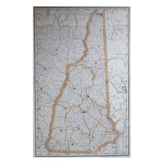
Large Original Antique Map of New Hampshire, USA, 1894
By Rand McNally & Co.
Located in St Annes, Lancashire
Fabulous map of New Hampshire
Original color
By Rand, McNally & Co.
Published, 1894
Unframed
Free shipping.
Category
Antique 1890s American Maps
Materials
Paper
You May Also Like
Antique Map of New Brunswick, Nova Scotia and Surroundings by Johnson, 1872
Located in Langweer, NL
Antique map titled 'Johnson's Quebec, of the dominion of Canada (..)'. Original map of New Brunswick, Nova Scotia, Newfoundland and Prince Edward Island....
Category
Antique Late 19th Century Maps
Materials
Paper

$335 Sale Price
20% Off
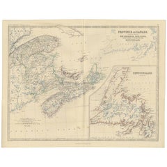
Decorative Antique Map of Eastern Canada, Published in 1882
Located in Langweer, NL
This is a historical map from the 1882 Blackie Atlas, focused on eastern Canada and the maritime provinces. The map is titled "Canada. No. 2. Provinces of Nova Scotia, New Brunswick,...
Category
Antique 1880s Maps
Materials
Paper

Antique Map of New Brunswick by W. G. Blackie, 1859
Located in Langweer, NL
Antique map titled 'New Brunswick, Nova Scotia, Prince Edward Island and Part of Canada east'. Original antique map of New Brunswick, Nova Scotia,...
Category
Antique Mid-19th Century Maps
Materials
Paper
$239 Sale Price
20% Off
Antique Map of the Province of Canada 'East' by A.K. Johnston, 1865
Located in Langweer, NL
Antique map titled 'Province of Canada (Eastern Sheet)'. Depicting New Brunswick, Newfoundland, Cape Breton Island, Prince Edward Island, Nova Scotia and m...
Category
Antique Mid-19th Century Maps
Materials
Paper
$249 Sale Price
20% Off
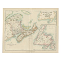
Antique Map of Eastern Canada with an inset Map of Newfoundland, 1882
Located in Langweer, NL
Antique map titled 'Dominion of Canada'. Old map of Eastern Canada with an inset map of Newfoundland. This map originates from 'The Royal Atlas of Modern Geography, Exhibiting, in a ...
Category
Antique 19th Century Maps
Materials
Paper

$268 Sale Price
20% Off
Antique Map of Canada by Johnston '1909'
Located in Langweer, NL
Antique map titled 'Dominion of Canada'. Original antique map of Canada. With inset map of Newfoundland. This map originates from the ‘Royal Atla...
Category
Early 20th Century Maps
Materials
Paper
$239 Sale Price
20% Off
More Ways To Browse
Antique Furniture Brunswick
Used Furniture Nova Scotia
Nova Scotia Antique Furniture
Antique Map Nova Scotia
Map New Holland
Treasure Map
Caribbean Antiques
19th Century Map Of Africa
Antique Malaysia
Antique Map Of Ireland
Ships Log
Map Of Egypt
Nautical Maps
Antique Maps Of Long Island
James Cook Map
Antique Doctors Office Furniture
Pirate Furniture
Railroad Collectibles