Items Similar to Original Antique Map of the Road from Andover to Crewkerne

Want more images or videos?
Request additional images or videos from the seller
1 of 6
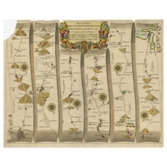
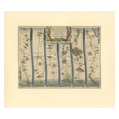
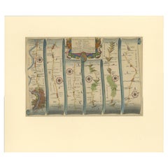
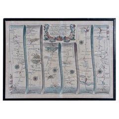
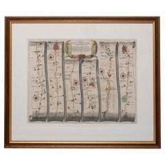
Original Antique Map of the Road from Andover to Crewkerne
$727.60
$909.5020% Off
£546.69
£683.3620% Off
€616
€77020% Off
CA$1,001.92
CA$1,252.4020% Off
A$1,121.33
A$1,401.6620% Off
CHF 586.98
CHF 733.7220% Off
MX$13,622.12
MX$17,027.6520% Off
NOK 7,453.10
NOK 9,316.3820% Off
SEK 7,033.28
SEK 8,791.6020% Off
DKK 4,688.37
DKK 5,860.4720% Off
About the Item
Antique map titled 'The Continuations of the Road from London to the Lands End'. Original antique map of the road from Andover to Crewkerne. Plate 26 from Ogilby's 'Britannia', the first national road-atlas of any country in Western Europe. It was composed of maps of seventy-three major roads and cross-roads, presented as trompe-l'oeil scrolls, each with a decorative title cartouche, in this case rustic figures. It was the first English atlas on a uniform scale, at one inch to a mile, and the 'mile' Ogilby used became the national standard, the statute mile of 1,760 yards. Ogilby claimed that 26,600 miles of roads were surveyed in the course of preparing the atlas, on foot using the surveyor's wheel depicted in the cartouche, but only about 7,500 were actually depicted in print. It was only after the 'Britannia' that roads started being shown on county maps.
- Dimensions:Height: 14.85 in (37.7 cm)Width: 17.72 in (45 cm)Depth: 0.02 in (0.5 mm)
- Materials and Techniques:
- Period:Late 17th Century
- Date of Manufacture:circa 1675
- Condition:General age-related toning. Original folding line. Shows wear and soiling. Several small defects in margins. Blank verso. Please study image carefully.
- Seller Location:Langweer, NL
- Reference Number:Seller: BG-13324-71stDibs: LU3054333590542
About the Seller
5.0
Recognized Seller
These prestigious sellers are industry leaders and represent the highest echelon for item quality and design.
Platinum Seller
Premium sellers with a 4.7+ rating and 24-hour response times
Established in 2009
1stDibs seller since 2017
2,534 sales on 1stDibs
Typical response time: <1 hour
- ShippingRetrieving quote...Shipping from: Langweer, Netherlands
- Return Policy
Authenticity Guarantee
In the unlikely event there’s an issue with an item’s authenticity, contact us within 1 year for a full refund. DetailsMoney-Back Guarantee
If your item is not as described, is damaged in transit, or does not arrive, contact us within 7 days for a full refund. Details24-Hour Cancellation
You have a 24-hour grace period in which to reconsider your purchase, with no questions asked.Vetted Professional Sellers
Our world-class sellers must adhere to strict standards for service and quality, maintaining the integrity of our listings.Price-Match Guarantee
If you find that a seller listed the same item for a lower price elsewhere, we’ll match it.Trusted Global Delivery
Our best-in-class carrier network provides specialized shipping options worldwide, including custom delivery.More From This Seller
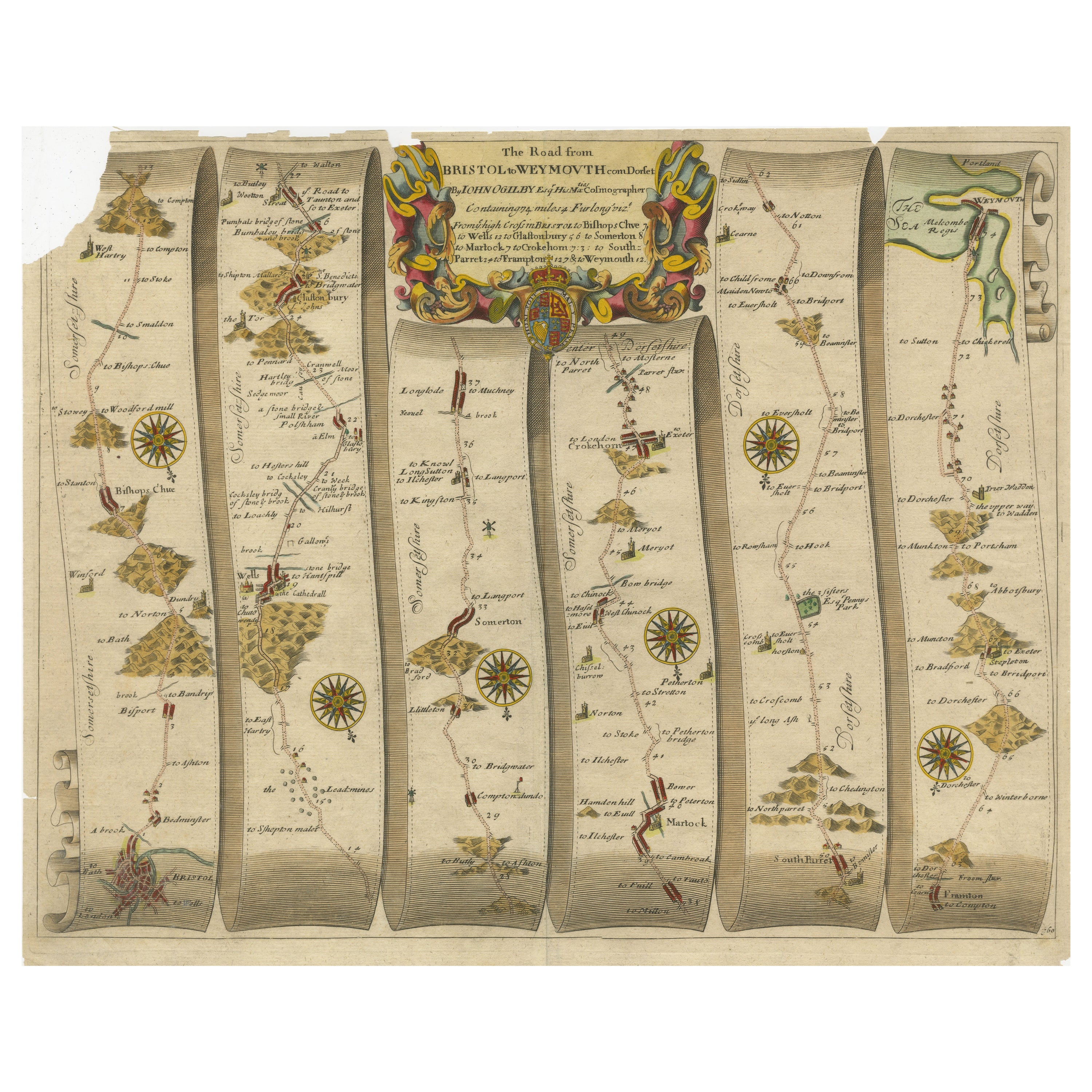
View AllOriginal Antique Map of the Road from Bristol to Weymouth
Located in Langweer, NL
Antique map titled 'The Road from Bristol to Weymouth (..)'. Original antique map of the road from Bristol to Weymouth. Plate 60 from Ogilby's 'Britannia', the first road atlas of En...
Category
Antique Late 17th Century Maps
Materials
Paper
$207 Sale Price
20% Off
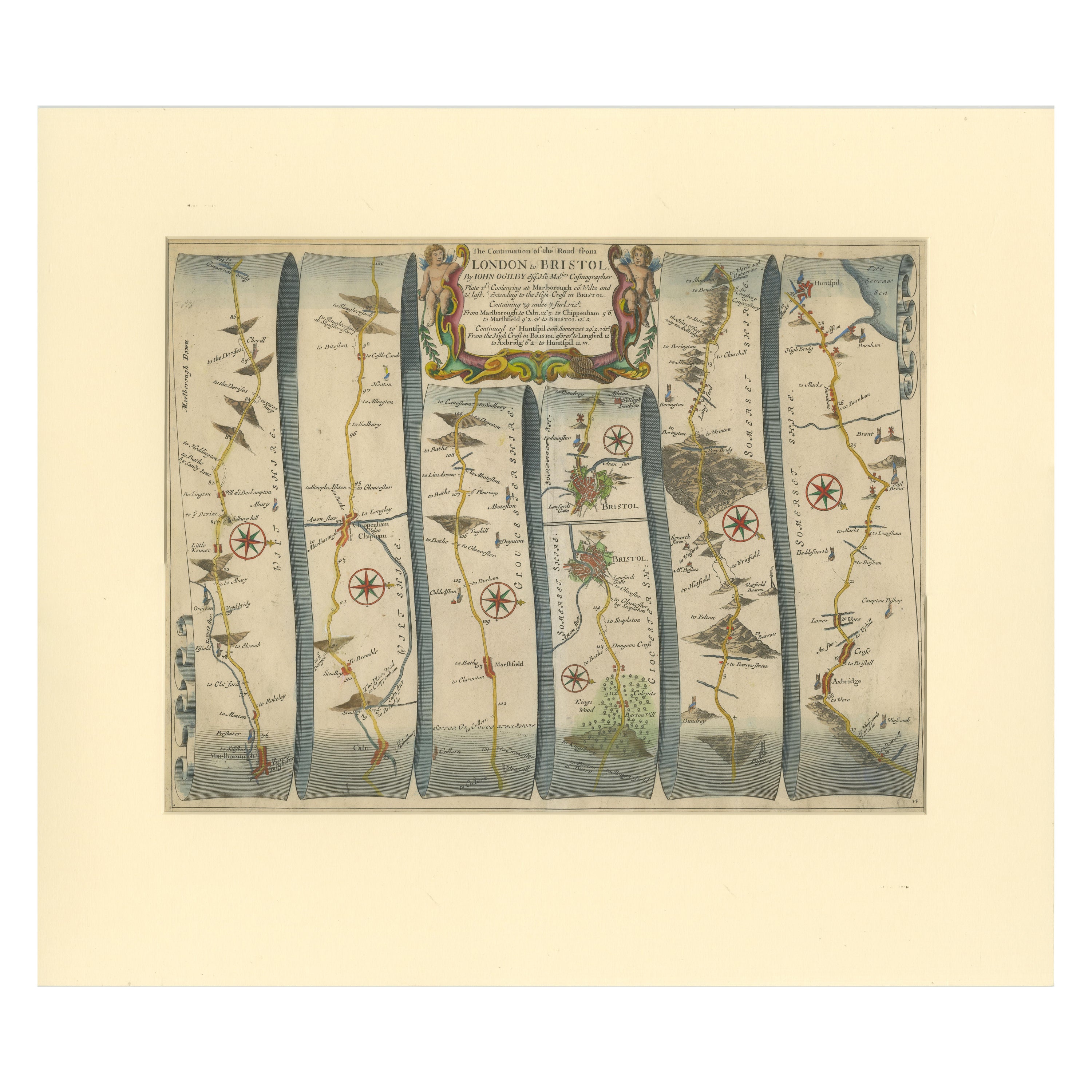
Original Antique Map of the Road from Marlborough to Huntspil
Located in Langweer, NL
Antique map titled 'The Continuation of the Road from London to Bristol (..)'. A strip map of the continuation of the road from London to Bristol, this particular sheet showing the r...
Category
Antique Late 17th Century Maps
Materials
Paper
$510 Sale Price
20% Off
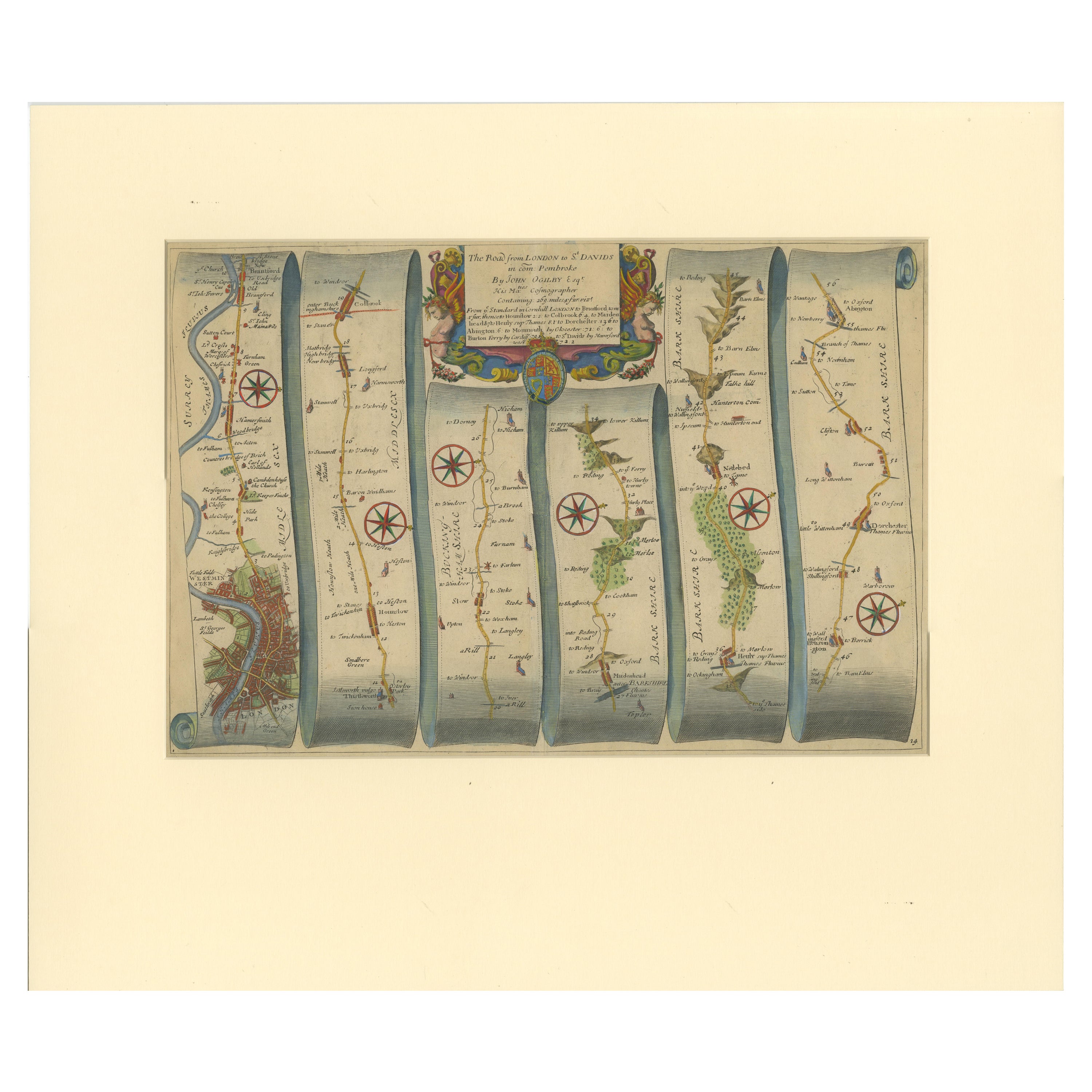
Original Antique Map of the Road from London to Bensington
Located in Langweer, NL
Antique map titled 'The Road from London to St. Davids in com: Pembroke (..)'. A strip map of the road from London to Bensington. The map is ornamented with numerous compass roses, a...
Category
Antique Late 17th Century Maps
Materials
Paper
$510 Sale Price
20% Off
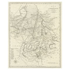
Large Antique County Map of Cambridgeshire, England
Located in Langweer, NL
Antique map titled 'A Map of Cambridgeshire from the best Authorities'. Original old county map of Cambridgeshire, England. Engraved by John Cary. Originates from 'New British Atlas'...
Category
Antique Early 19th Century Maps
Materials
Paper
$217 Sale Price
20% Off
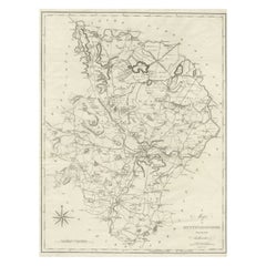
Large Antique County Map of Huntingdonshire, England
Located in Langweer, NL
Antique map titled 'A Map of Huntingdonshire from the best Authorities'. Original old county map of Huntingdonshire, England. Engraved by John Cary. Originates from 'New British Atla...
Category
Antique Early 19th Century Maps
Materials
Paper
$217 Sale Price
20% Off
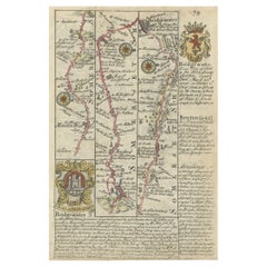
Rare Antique Map of the Route from Maiden Bridge to Dulverton, England, c.1720
By Bowen
Located in Langweer, NL
Antique map titled 'Bridgewater, Bruton'.
Double sided road strip map showing the route from Maiden Bridge to Dulverton, via Bruton, Weston Regis, Bridgewater and Dulverton. This map originates from 'Britannia Depicta or Ogilby Improv'd' by J. Owen and E. Bowen.
Artists and Engravers: The Owen and Bowen road strip maps were based on the far larger ones done by John Ogilby in the 1670s. Each map was finely engraved by Emanuel Bowen, who was one of the most renowned and prolific map makers of the 18th century. The maps also had the added feature of copius amounts of information, written by John Owen...
Category
Antique 18th Century Maps
Materials
Paper
$132 Sale Price
20% Off
You May Also Like
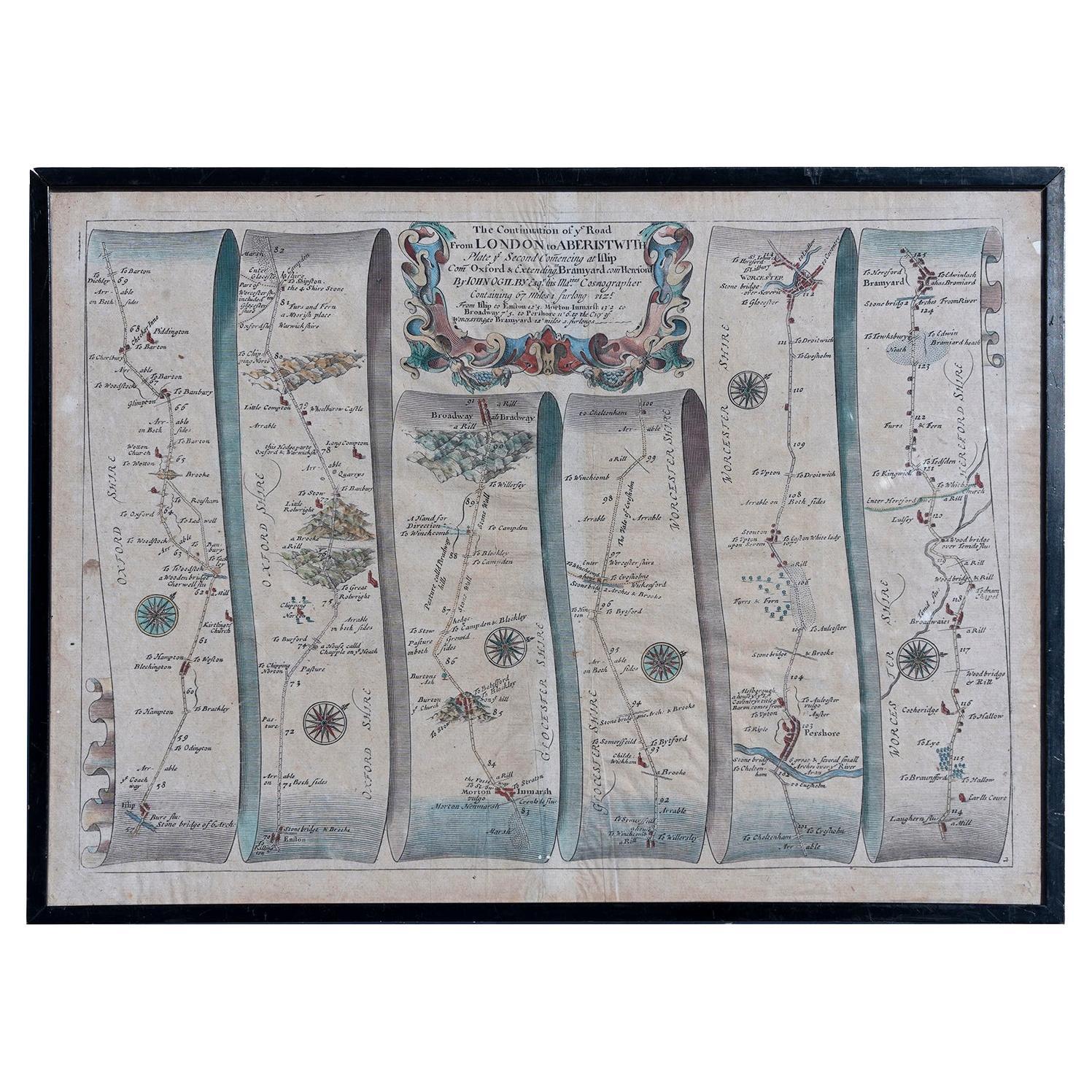
Map Road Strip Britannia Sheet 2 John Ogilby London Aberistwith Islip Bramyard
By John Ogilby
Located in BUNGAY, SUFFOLK
From John Ogilby's, 'Britannia, an Illustration of the Kingdom of
England and Dominion of Wales'. First published in 1675 it remains the greatest advance ...
Category
Antique 17th Century English Baroque Maps
Materials
Paper
Road Map No43 London to Kings Lynn, Royston to Downham, John Ogilby, Britannia
By John Ogilby
Located in BUNGAY, SUFFOLK
John Ogilby (British 1600-1676) Cosmographer and Geographick Printer to Charles II.
A road map from Britannia, 1675/6. The road from London to Kings Lynn, showing Royston to Downham. In oak and gilded frame.
In a remarkable life John Ogilby pursued, several careers, each ending in misfortune, and yet he always emerged undeterred, to carry on. His modern reputation is based on his final career, started in his sixty-sixth year, as a publisher of maps and geographical accounts.
Ogilby was born outside Dundee, in 1600, the son of a Scottish gentleman...
Category
Antique Late 17th Century British Charles II Maps
Materials
Paper
Antique West Yorkshire Map, English, Framed Lithography, Cartography, Victorian
Located in Hele, Devon, GB
This is an antique lithography map of West Yorkshire. An English, framed atlas engraving of cartographic interest, dating to the mid 19th century and later.
Superb lithography of t...
Category
Antique Mid-19th Century British Victorian Maps
Materials
Paper
Map Road John Ogilby Britannia No 74 Ipswich to Norwich Cromer Framed
By John Ogilby
Located in BUNGAY, SUFFOLK
The Road from Ipswich com Suffolk to Norwich and thence to cromer on the sea coast com Norfolk. By John Ogilby, Esq, His Majesties Cosmographer. Containing...
Category
Antique 1670s English Baroque Maps
Materials
Paper
Road Map, John Ogilby, No 54, London, Yarmouth, Britannia
By John Ogilby
Located in BUNGAY, SUFFOLK
The Road from London to Yarmouth com. Norfolk. By John Ogilby, His Majesties Cosmographer. Containing 122 miles, 5 furlongs. No 54.
From Standard in Co...
Category
Antique 1670s English Baroque Maps
Materials
Paper
Road Map, John Ogilby, London, Barwick, York, Chester, Darlington, Durham Framed
By John Ogilby
Located in BUNGAY, SUFFOLK
The continuation of the road from London to Barwick beginning at York and extending to Chester in ye Street. Plate ye 4th continuing 76 ½ miles. No 8.
York to Burrowbridge, to Top...
Category
Antique 1670s English Baroque Maps
Materials
Paper
