
Mauritius Antique Map

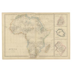
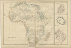
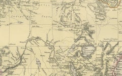
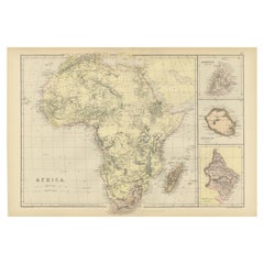
Antique Old Map of Africa with Insets of Mauritius, Reunion and Natal, 1882
Located in Langweer, NL
right-hand side show detailed maps of Mauritius, "Bourbon" (now Réunion), and Natal (a region in South
Category

1880s Mauritius Antique Map

Materials

Paper

Antique Engravings of Mauritius and Indonesia, incl de Banda Islands, c.1730
Located in Langweer, NL
Title on page: "Ins. de Cerno a. Nostatibus Mauritius Nominata [on sheet with] Gunnanappi Labetacq
Category

1730s Mauritius Antique Map

Materials

Paper

Antique Map of the Coast of Zanguebar and Madagascar 'Africa' by J. van Schley
Located in Langweer, NL
Decorative map of the area between the east coast of South Africa, the Seychelles, Mauritius and
Category

Mid-18th Century Mauritius Antique Map

Materials

Paper

Early Map of Australasia, Marking The Route of Abel Tasman in 1642 'Publ. 1726'
Located in Langweer, NL
and early map of Australasia, marking the route of Abel Tasman's voyage from Mauritius to Batavia in
Category

1720s Mauritius Antique Map

Materials

Paper

An exceptional pair of BLAEU table globes
By Willem Blaeu
Located in ZWIJNDRECHT, NL
maps, atlases and instruments. Blaeu’s globes were luxury items for wealthy and intellectual merchants
Category

17th Century European Dutch Colonial Mauritius Antique Map

Materials

Other

Antique         An exceptional pair of BLAEU table globes
        An exceptional pair of BLAEU table globes
Free Shipping
H 15 in Dm 9 in

People Also Browsed

Wonderful and extremely rare Dutch pocketglobe
By Dementz Family DEUR Art Company
Located in ZWIJNDRECHT, NL
Only three copies worldwide. Miniature terrestrial pocket globe in a celestial case made by Johannes Deur. Amsterdam, 1720. Diameter of 2,5 inches / 6 cm. 2 legends are inscribed a...
Category

Early 18th Century Dutch Dutch Colonial Mauritius Antique Map

Materials

Hardwood, Paper

Antique Wonderful and extremely rare Dutch pocketglobe
Wonderful and extremely rare Dutch pocketglobe
Free Shipping
H 2.5 in Dm 2.5 in
A truly delightful miniature terrestrial pocket globe
By Nathaniel Mills
Located in ZWIJNDRECHT, NL
A truly delightful miniature terrestrial pocket globe in a celestial case, 3 inches / 6.8 cm. The globe consists of 12 wonderful varnished, engraved hand-coloured gores that stretch ...
Category

Mid-18th Century British Dutch Colonial Mauritius Antique Map

Materials

Other

Antique Print of the Fortress Cranganor near Kodungallur in India, 1757
Located in Langweer, NL
Antique print of the Fortress Cranganor, nowadays known by the name Kodungallor. French and Dutch title including scale and compass rose. This print originates from 'L'Histoire génér...
Category

Mid-18th Century Mauritius Antique Map

Materials

Paper

Antique Map of Asia Minor by J. Tallis, circa 1851
Located in Langweer, NL
A highly decorative mid-19th century map of 'Asia Minor' (modern day Turkey) which was drawn and engraved by J. Rapkin and published in John Tallis's Illustrated Atlas (London & New ...
Category

Mid-19th Century Mauritius Antique Map

Materials

Paper

English Pocket Globe, London, Circa 1775-1798
By Herman Moll
Located in Milano, IT
Pocket globe London, between 1775 and 1798 Re-edition of the globe of Hermann Moll (1678-1732) dated 1719 The globe is contained in its original case, which itself is covered in sh...
Category

Late 18th Century English George III Mauritius Antique Map

Materials

Shagreen, Paper

Scrimshaw of engraved whale tooth depicting naked woman with very 1850s face
Located in Milan, IT
Scrimshaw of an engraved whale tooth, depicting naked woman with a very end, with long hair and turgid breasts flying the American flag, on the back large vessel with sails unfu...
Category

Mid-19th Century Mauritius Antique Map

Materials

Teeth

Antique Map of Herefordshire 'England' by R. Morden, 1708
Located in Langweer, NL
This antique County map of Herefordshire by Robert Morden was first published in 1701 in a work entitled 'The New Description and State of England', however, a subsequent edition by ...
Category

Early 18th Century Mauritius Antique Map

Materials

Paper

Colored wall map of the WORLD
By Chambon
Located in ZWIJNDRECHT, NL
“Mappe Monde, contenant les Parties Connues du Globe Terrestre” CHAMBON, Gobert-Denis (France, 17.. - 1781) Paris, Longchamps et Janvier, 1754 Size H. 115 x W. 145 cm. Gobert-Denis...
Category

Mid-18th Century French French Provincial Mauritius Antique Map

Materials

Wood, Paper

Colored wall map of the WORLD
Free Shipping
H 45 in W 57 in D 0.8 in
Pocket Globe, Nicholas Lane, London, post 1779
By Nicholas Lane
Located in Milano, IT
Pocket Globe Nicholas Lane London, post 1779 The globe is contained in its original case, which is covered in leather. The sphere measures 2.75 in (6.9 cm) whereas the case measure...
Category

1780s English Other Mauritius Antique Map

Materials

Leather, Wood, Paper

Antique Print with Hand Coloring of a Tasmanian Tiger or Tasmanian Wolf
Located in Langweer, NL
The uploaded image, labeled as 'The Zebra or Dog-Faced Dasyurus', depicts a thylacine, which was also known as the Tasmanian tiger or Tasmanian wolf. This is an interesting historica...
Category

Mid-19th Century Mauritius Antique Map

Materials

Paper

Antique Brass Salmon Fishing Reel
Located in Oxfordshire, GB
A beautiful salmon fishing reel by Cummings of Bishop Auckland. This brass or gun metal reel is a very nice original example with the original coating. The brass foot has not been ta...
Category

Early 1900s British Edwardian Mauritius Antique Map

Materials

Brass

Antique Map of North Africa by Ortelius, c.1580
Located in Langweer, NL
Antique map titled 'Barbariae et Biledulgerid Nova Descriptio'. Original antique map of North Africa. The map covers the regions of Barbaria and Biledulgerid, essentially the territo...
Category

16th Century Mauritius Antique Map

Materials

Paper

Large Original Vintage Map of South Africa, circa 1920
Located in St Annes, Lancashire
Great map of South Africa Original color. Good condition / repair to a minor edge tear middle bottom Published by Alexander Gross Unframed.
Category

1920s English Edwardian Mauritius Antique Map

Materials

Paper

Large Original Vintage Map of South Africa, circa 1920
No Reserve
H 25 in W 19.5 in D 0.07 in
The River War by Winston S. Churchill, First Edition, Two Volume Set, 1899
By Winston Churchill
Located in Colorado Springs, CO
Churchill, Winston S. The River War: An Historical Account of the Reconquest of the Soudan. London: Longmans, Green, and Co., 1899. Edited by Col. F. Rhodes, D.S.O. Illustrated by Ag...
Category

1890s British Mauritius Antique Map

Materials

Leather, Paper

Antique Map of the Island of Java, Indonesia by P. Van Der Aa, 1713
Located in Langweer, NL
This rare map shows the Indonesian island of Java. With compass rose and scale. From: Nouvel Atlas, très exact et fort commode pour toutes sortes de personnes, Contenant Les Principa...
Category

Early 18th Century Mauritius Antique Map

Materials

Paper

Scrimshaw of whale tooth engraved with 1820s truncated pyramid cippus and Man
Located in Milan, IT
Scrimshaw of an engraved whale's tooth, depicting on one side, truncated pyramid cippus culminating with a half sphere and surmounted at the top by a six-pointed star, symbolism trac...
Category

1820s Mauritius Antique Map

Materials

Teeth

Recent Sales

Original Vintage Cruise Ship Travel Poster P&O British India Sailings Route Map
By Henry George Gawthorn
Located in London, GB
, Burmah, Siam, Mauritius, East and South Africa, New Zealand, Australia, Tasmania, Polynesia Straits
Category

1920s British Mauritius Antique Map

Materials

Paper

Antique Map of Africa by W. G. Blackie, 1859
Located in Langweer, NL
Antique map titled 'Africa'. Original antique map of Africa with inset maps of Mauritius, Bourbon
Category

Mid-19th Century Mauritius Antique Map

Materials

Paper

Antique Map of Africa by W. G. Blackie, 1859
H 14.57 in W 21.26 in D 0.02 in
Original Vintage Cruise Ship Travel Poster P&O British India Sailings Route Map
By Henry George Gawthorn
Located in London, GB
, Burmah, Siam, Mauritius, East and South Africa, New Zealand, Australia, Tasmania, Polynesia Straits
Category

1920s Mauritius Antique Map

Materials

Paper

Get Updated with New Arrivals
Save "Mauritius Antique Map", and we’ll notify you when there are new listings in this category.

Read More

Pamela Shamshiri Shares the Secrets behind Her First-Ever Book and Its Effortlessly Cool Interiors

The sought-after designer worked with the team at Hoffman Creative to produce a monograph that beautifully showcases some of Studio Shamshiri's most inspiring projects.

Moroccan Artworks and Objects Take Center Stage in an Extraordinary Villa in Tangier

Italian writer and collector Umberto Pasti opens the doors to his remarkable cave of wonders in North Africa.

Montecito Has Drawn Royalty and Celebrities, and These Homes Are Proof of Its Allure

Hollywood A-listers, ex-pat aristocrats and art collectors and style setters of all stripes appreciate the allure of the coastal California hamlet — much on our minds after recent winter floods.

Whaam! Blam! Pow! — a New Book on Pop Art Packs a Punch

Publishing house Assouline and writer Julie Belcove have teamed up to trace the history of the genre, from Roy Lichtenstein, Andy Warhol and Yayoi Kusama to Mickalene Thomas and Jeff Koons.

The Sparkling Legacy of Tiffany & Co. Explained, One Jewel at a Time

A gorgeous new book celebrates — and memorializes — the iconic jeweler’s rich heritage.

What Makes a Gem-Encrusted Chess Set Worth $4 Million?

The world’s most opulent chess set, weighing in at 513 carats, is literally fit for a king and queen.

Tauba Auerbach’s Geometric Pop-Up Book Is Mighty Rare, Thanks to a Hurricane

This sculptural art book has an epic backstory of its own.

Step inside the Storied Mansions of Palm Beach’s Most Effervescent Architect

From Spanish-style courtyards to fanciful fountains, these acclaimed structures abound in surprising and elegant details.