Items Similar to Antique Engravings of Mauritius and Indonesia, incl de Banda Islands, c.1730


Want more images or videos?
Request additional images or videos from the seller
1 of 6
Antique Engravings of Mauritius and Indonesia, incl de Banda Islands, c.1730
About the Item
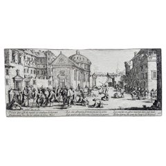
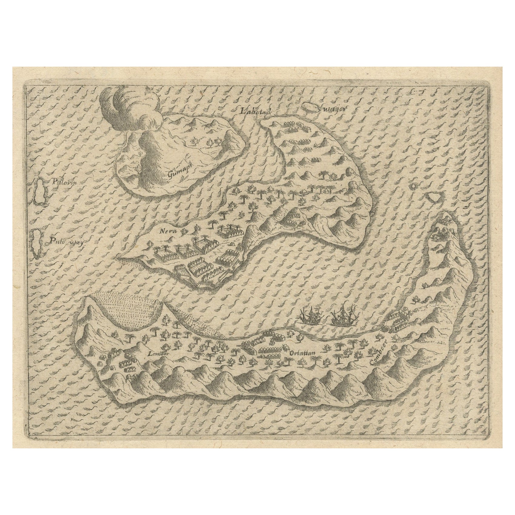
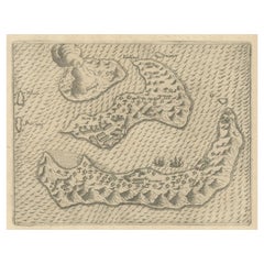
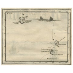
Title on page: "Ins. de Cerno a. Nostatibus Mauritius Nominata [on sheet with] Gunnanappi Labetacq [and] Civitas Gammelamme [and] Rex Tubatus", Le Clerc, Jean
This sheet includes four engravings, published in a history of Dutch exploration:
1. Top left: shows natives on Mauritius fishing and building a boat, with a dodo (extinct) and two turtles at right.
2. Top right: the Banda islands (also known as the Spice Islands) of Banda Api, Banda Neira and Banda Besar.
3. Bottom left: a procession for the king of Ternate in the town of Gamalama.
4, Bottom right: a procession for the king of Tuban, Java, riding an elephant.
Subject: Islands in Indonesia & Mauritius
Period: Circa 1730
Color: hand color
Size: 12.5 x 8.8 inches / 31.8 x 22.4 cm
A nice impression on a sheet with a leaf-shaped watermark, light toning along the centerfold, and light soiling mostly confined to the blank margins.
- Dimensions:Height: 8.82 in (22.4 cm)Width: 12.52 in (31.8 cm)Depth: 0 in (0.02 mm)
- Materials and Techniques:
- Period:1730-1739
- Date of Manufacture:circa 1730
- Condition:A nice impression on a sheet with a leaf-shaped watermark, light toning along the centerfold, and light soiling mostly confined to the blank margins.
- Seller Location:Langweer, NL
- Reference Number:
About the Seller
5.0
Platinum Seller
These expertly vetted sellers are 1stDibs' most experienced sellers and are rated highest by our customers.
Established in 2009
1stDibs seller since 2017
1,932 sales on 1stDibs
Typical response time: <1 hour
- ShippingRetrieving quote...Ships From: Langweer, Netherlands
- Return PolicyA return for this item may be initiated within 14 days of delivery.
More From This SellerView All
- Antique Chart of the Banda Islands or The Spice Islands, Indonesia, 1726Located in Langweer, NLAntique map titled 'Nieuwe Caart der Eylanden van Banda'. Beautiful chart of the Banda Islands including Banda Api, Banda Neira, Banda Besar, Pulau Hatta (Rosengain), Pulau Ai an...Category
Antique 1720s Maps
MaterialsPaper
- Antique Map of the Banda Islands in Indonesia by Valentijn, 1726Located in Langweer, NLAntique map Indonesia titled 'Kaart der Zuyd-Wester Eylanden van Banda'. Map of the islands in the southwestern part of the Banda Sea including ...Category
Antique Mid-18th Century Maps
MaterialsPaper
- Rare Antique Pap Depicting the Banda Islands or Spice Islands, Indonesia, c.1600Located in Langweer, NLAntique map Indonesia titled 'Bandae Insulae designatio'. Antique map depicting the Banda Islands, Indonesia. With Latin text, blank verso. Orig...Category
Antique Early 1600s Maps
MaterialsPaper
- Old Antique Map of the Banda Islands (Southeast), Indonesia & Northern AustraliaBy F. ValentijnLocated in Langweer, NLOriginal antique map titled 'Kaart van de Zuyd-Ooster Eylanden van Banda'. Important map of the seas and islands surrounding the Banda Islands, Indonesia, extending south to northern Australia, east to Papua New Guinea and north to Ceram. Published 1724-1726 by Joannes van Braam...Category
Antique Early 18th Century Maps
MaterialsPaper
- Antique Map of the Banda Islands and the Route of Abel Tasman, Indonesia, 1726Located in Langweer, NLAntique print Indonesia with an image on each side. The first image depicts Ontong Java, one of the largest atolls on earth. On verso: antique map of the Banda Islands. With the rout...Category
Antique 1720s Maps
MaterialsPaper
- Original Antique Map Southeast of the Banda or Spice Islands, Indonesia, 1726Located in Langweer, NLAntique map titled 'Kaart van de Zuyd-Ooster Eylanden van Banda'. Map of the southeastern part of the Banda islands. This map originates from 'Oud en Nieuw Oost-Indiën' by F. Valen...Category
Antique 1720s Maps
MaterialsPaper


You May Also Like
- 1864 "Proclamation of Emancipation, " Antique Engraving by Charles ShoberLocated in Colorado Springs, COThis 1865 engraving features the Emancipation Proclamation in elaborate calligraphic text, with five patriotic vignettes and a small portrait...Category
Antique 1860s American Historical Memorabilia
MaterialsPaper
- “A Football Match, Scotland v. England” Antique Engraving, Proof Edition of 100By Overend and SmytheLocated in Colorado Springs, COThis is the 1889 William H. Overend (1851-1898) and Lionel Smythe (1839-1918) first edition, photogravure of the Calcutta Cup – a Rugby match between Scotland and England, that has been played over 100 times, the first match...Category
Antique 19th Century English Prints
MaterialsPaper
- Jacques Callot "Misères Et Malheurs De La Guerre" Collection of Engraving 17thBy Jacques CallotLocated in Beuzevillette, FR“Les Misères Et Les Malheurs De La Guerre” (“The misfortunes of war”) more commonly called “the great miseries of war” (“The great miseries of war”) is a major work by the 17th centu...Category
Antique 17th Century French Louis XIII Prints
MaterialsPaper
- Antique Golf Engraving, Henry Callender ESQ, Golf MezzotintLocated in Oxfordshire, GBGolf mezzotint of 'Henry Callender Esq' (Captain of the society of Golfers at Blackheath) after Lemuel Francis Abbott (1760-1803). Henry Callend...Category
Antique 1810s British Sporting Art Sports Equipment and Memorabilia
MaterialsPaper
- 1865 Emancipation Proclamation with Abraham Lincoln Portrait, Antique EngravingLocated in Colorado Springs, COPresented is an elaborate engraved broadside presentation of both the preliminary and final Emancipation Proclamations, dated September 22, 1...Category
Antique 1860s American Historical Memorabilia
MaterialsPaper
- 1864 Abraham Lincoln's Emancipation Proclamation, Antique Engraving by W RobertsLocated in Colorado Springs, COPresented is a Proclamation of Emancipation wood engraving by W. Roberts. The engraving was published in 1864, just one year after President Abraham Lincoln signed the original Proclamation. W. Roberts was the artist and engraver and Corydon Alexis Alvord was the printer. The engraving was published by R. A Dimmick, in New York, 1864. The text of the Proclamation is set in a variety of typefaces, which is encased in a pictorial border. The border is decorated with a portrait of Abraham Lincoln and seven other vignettes, including the horrors of slavery at left, the bombardment of Fort Sumter at bottom, and scenes from a prosperous and united nation at right. On September 22, 1862, five days after the Union victory at the Battle of Antietam, Lincoln issued a preliminary decree stating that, unless the rebellious states returned to the Union by January 1, freedom would be granted to slaves within those states. No Confederate states took the offer, and on January 1, 1863 Lincoln presented the Emancipation Proclamation...Category
Antique 1860s American Historical Memorabilia
MaterialsPaper