Items Similar to Original Antique Map Southeast of the Banda or Spice Islands, Indonesia, 1726


Want more images or videos?
Request additional images or videos from the seller
1 of 6
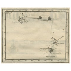
Original Antique Map Southeast of the Banda or Spice Islands, Indonesia, 1726
About the Item
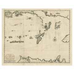
Antique map titled 'Kaart van de Zuyd-Ooster Eylanden van Banda'.
Map of the southeastern part of the Banda islands. This map originates from 'Oud en Nieuw Oost-Indiën' by F. Valentijn.
Artists and Engravers: François Valentijn (1666-1727), a missionary, worked at Amboina from 1684 to 1694 and 1705 to 1713 and travelled extensively in the VOC's lands.
Condition: Good, repair on lower folding line. Please study image carefully.
- Dimensions:Height: 19.69 in (50 cm)Width: 23.23 in (59 cm)Depth: 0 in (0.02 mm)
- Materials and Techniques:
- Period:1720-1729
- Date of Manufacture:1726
- Condition:Repaired: Repair on lower folding line. Please study image carefully. Wear consistent with age and use. Condition: Good, repair on lower folding line. Please study image carefully.
- Seller Location:Langweer, NL
- Reference Number:
About the Seller
5.0
Platinum Seller
These expertly vetted sellers are 1stDibs' most experienced sellers and are rated highest by our customers.
Established in 2009
1stDibs seller since 2017
1,933 sales on 1stDibs
Typical response time: <1 hour
- ShippingRetrieving quote...Ships From: Langweer, Netherlands
- Return PolicyA return for this item may be initiated within 14 days of delivery.
More From This SellerView All
- Antique Chart of the Banda Islands or The Spice Islands, Indonesia, 1726Located in Langweer, NLAntique map titled 'Nieuwe Caart der Eylanden van Banda'. Beautiful chart of the Banda Islands including Banda Api, Banda Neira, Banda Besar, Pulau Hatta (Rosengain), Pulau Ai an...Category
Antique 1720s Maps
MaterialsPaper
- Antique Map of the Banda Islands in Indonesia by Valentijn, 1726Located in Langweer, NLAntique map Indonesia titled 'Kaart der Zuyd-Wester Eylanden van Banda'. Map of the islands in the southwestern part of the Banda Sea including ...Category
Antique Mid-18th Century Maps
MaterialsPaper
- Old Antique Map of the Banda Islands (Southeast), Indonesia & Northern AustraliaBy F. ValentijnLocated in Langweer, NLOriginal antique map titled 'Kaart van de Zuyd-Ooster Eylanden van Banda'. Important map of the seas and islands surrounding the Banda Islands, Indonesia, extending south to northern Australia, east to Papua New Guinea and north to Ceram. Published 1724-1726 by Joannes van Braam...Category
Antique Early 18th Century Maps
MaterialsPaper
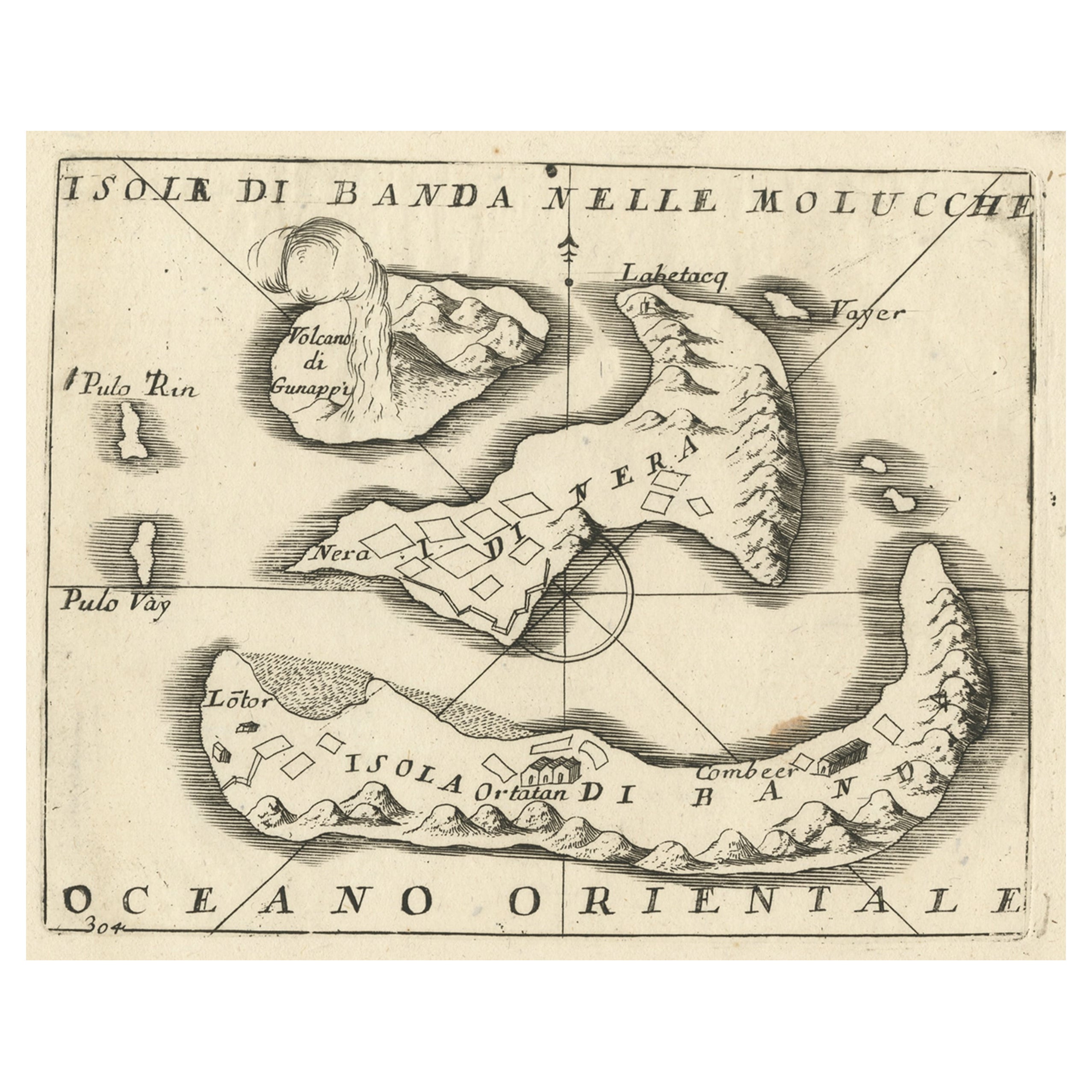
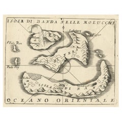
- Small Old Map Depicting the Banda Islands or the Spice Islands, Indonesia, 1706Located in Langweer, NLAntique map titled 'Isole di Banda Nelle Molucche'. Small old map depicting the Banda Islands, Indonesia. Artists and Engravers: Published by V.M. Coronelli in Venice, 1706.Category
Antique Early 1700s Maps
MaterialsPaper
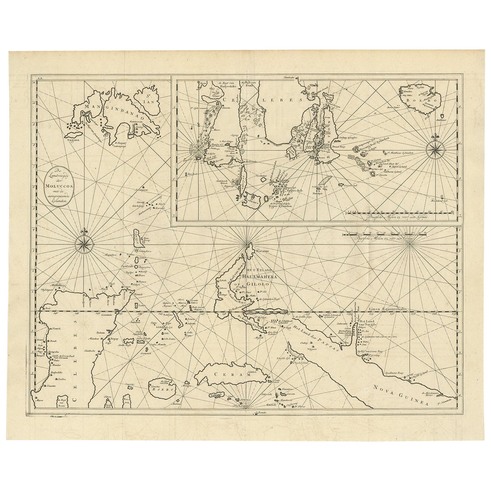
- Large Antique Detailed Map of a Part of the Spice Islands, Indonesia, 1726Located in Langweer, NLAntique matitled 'De Landvoogdy der Moluccos met de aangrenzende Eylanden'. Large detailed map of a part of the Spice Islands. It includes Baru (Boero), Ambon, Seram and part of Ma...Category
Antique 1720s Maps
MaterialsPaper
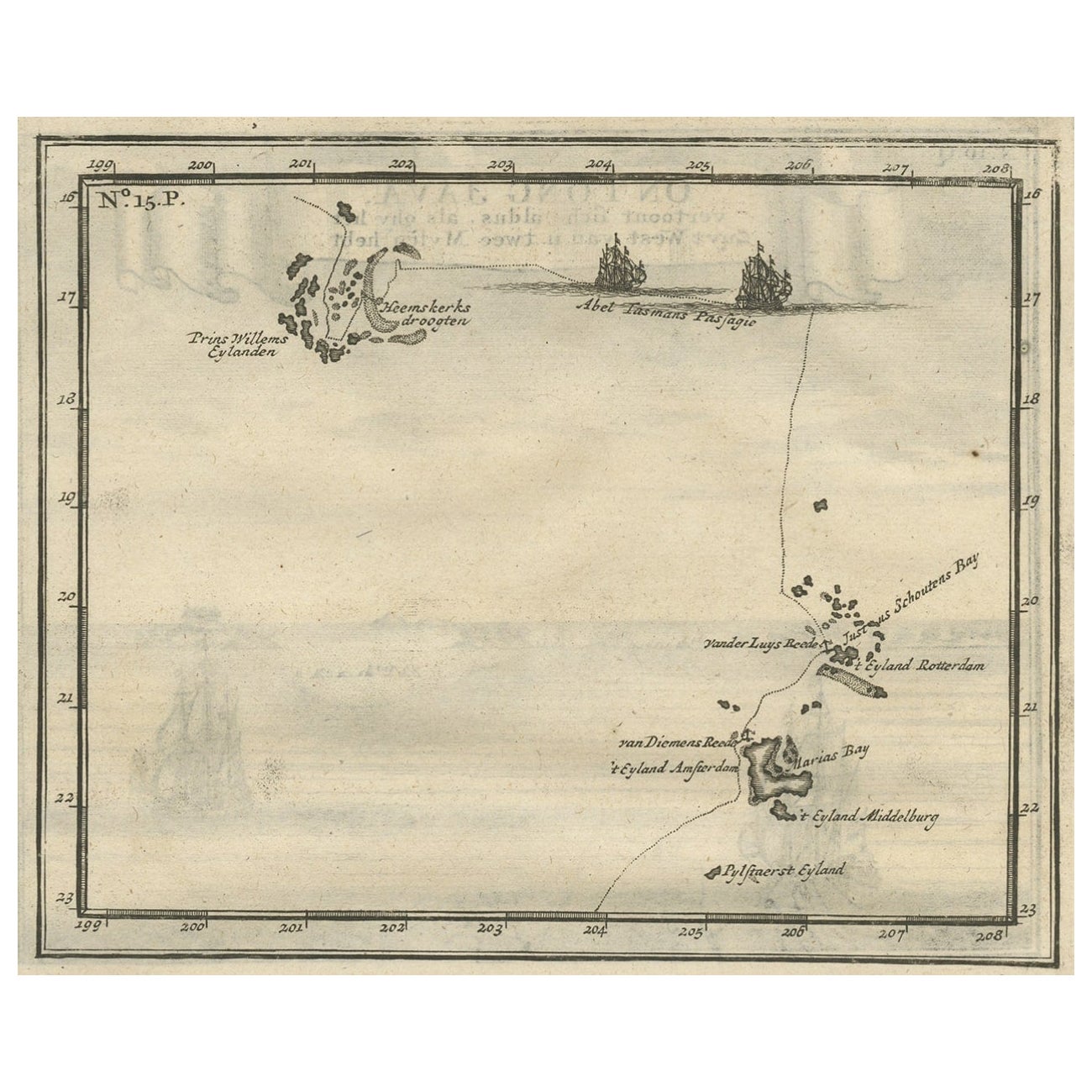
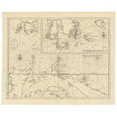
- Antique Map of the Banda Islands and the Route of Abel Tasman, Indonesia, 1726Located in Langweer, NLAntique print Indonesia with an image on each side. The first image depicts Ontong Java, one of the largest atolls on earth. On verso: antique map of the Banda Islands. With the rout...Category
Antique 1720s Maps
MaterialsPaper


You May Also Like
- Original Antique Map of Italy. C.1780Located in St Annes, LancashireGreat map of Italy Copper-plate engraving Published C.1780 Unframed.Category
Antique Early 1800s English Georgian Maps
MaterialsPaper

- Original Antique Map of Asia. C.1780Located in St Annes, LancashireGreat map of Asia Copper-plate engraving Published C.1780 Two small worm holes to right side of map Unframed.Category
Antique Early 1800s English Georgian Maps
MaterialsPaper

- Original Antique Map of India. C.1780Located in St Annes, LancashireGreat map of India Copper-plate engraving Published C.1780 Three small worm holes to right side of map and one bottom left corner Unframed.Category
Antique Early 1800s English Georgian Maps
MaterialsPaper

- Original Antique Map of The World by Thomas Clerk, 1817Located in St Annes, LancashireGreat map of The Eastern and Western Hemispheres On 2 sheets Copper-plate engraving Drawn and engraved by Thomas Clerk, Edinburgh. Published by Mackenzie And Dent, 1817 ...Category
Antique 1810s English Maps
MaterialsPaper
- Original Antique Map of China, Arrowsmith, 1820Located in St Annes, LancashireGreat map of China Drawn under the direction of Arrowsmith Copper-plate engraving Published by Longman, Hurst, Rees, Orme and Brown, 1820 Unfr...Category
Antique 1820s English Maps
MaterialsPaper
- Original Antique Map of Canada, Arrowsmith, 1820Located in St Annes, LancashireGreat map of Canada. Drawn under the direction of Arrowsmith. Copper-plate engraving. Published by Longman, Hurst, Rees, Orme and Brown, 1820 ...Category
Antique 1820s English Maps
MaterialsPaper


Recently Viewed
View AllMore Ways To Browse
Antique Spices
Used Oud
Indonesia Map
Antique Oud
Antique Map Indonesia
Antique Maps Indonesia
Voc Antique
Antique Map Southeast
Antique Furniture East London
Antique Eastern European Furniture
Antique House Plans
Antique Metal Window
Antique Metal Windows
Antique Furniture Rollers
Antiques Compasses
India Map
Antique Map Book
Antique Maps Book