Items Similar to Original Old Composite of Several Maps of the Ancient World on One Sheet, 1880
Want more images or videos?
Request additional images or videos from the seller
1 of 9
Original Old Composite of Several Maps of the Ancient World on One Sheet, 1880
$356.44
$445.5520% Off
£263.72
£329.6520% Off
€296
€37020% Off
CA$492.84
CA$616.0520% Off
A$541.08
A$676.3520% Off
CHF 282.28
CHF 352.8520% Off
MX$6,547.79
MX$8,184.7420% Off
NOK 3,537.96
NOK 4,422.4520% Off
SEK 3,333.69
SEK 4,167.1120% Off
DKK 2,253.75
DKK 2,817.1920% Off
About the Item
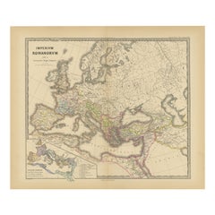
This original antique map is from Karl Spruner von Merz's "Atlas Antiquus", later edited by Theodorus Menke. The map is a detailed depiction of the ancient world. The atlas it comes from is known for its scholarly accuracy and was widely used for educational purposes in the 19th century.
This particular map likely represents multiple historical periods, given Spruner's comprehensive approach to cartography. The map is a colored lithograph with hand-colored borders, a common practice of the time to distinguish different regions or nations. It’s composed of several smaller maps and charts, each focusing on different regions or aspects of the ancient world. The main map seems to depict the classical lands of Europe, North Africa, and parts of Asia, reflecting the Roman Empire at its extent.
The map includes various Latin inscriptions, indicating regions, cities, and important geographical features such as rivers, mountains, and seas. It also contains tables and notes that would provide context and additional information to the viewer, likely historical data relevant to the periods and places shown.
Given the indicated publication year of 1880, this map was one of the later editions of Spruner’s atlas, at a time when such detailed historical atlases were particularly valuable to academics and educators. The combination of Spruner's detailed cartographic work and Menke's editing would have made this a significant educational resource for understanding historical geography.
This map, with its intricate detail and historical value, is not only a tool for learning but also a work of art, reflecting the high standards of craftsmanship and academic rigor of the period.
To observe the map in more detail and in various sections, read here:
1. **Top Left Corner**: A smaller inset map that appears to be a wind rose or a classical depiction of the known world, possibly showing the classical elements or winds with Greek or Latin inscriptions.
2. **Main Central Map**: This is the largest section and seems to show the ancient world, with parts of Europe, Northern Africa, and Asia. The territories are marked with different colors, possibly representing the boundaries of various empires or states.
3. **Bottom Left Corner**: Here, there are three inset maps. The topmost one appears to show the Arabian Peninsula; the middle one could be depicting the Nile delta and surrounding regions of Egypt; and the bottom one might be focusing on the island of Sicily with its Greek colonies.
4. **Bottom Center**: This section seems to be another detailed map, potentially zooming in on the Mediterranean region, featuring parts of Southern Europe, Northern Africa, and the Near East. The detail here suggests important cities, trade routes, or other significant historical features.
5. **Bottom Right Corner**: Similar to the bottom left, there are three inset maps. They likely depict specific regions of historical interest, possibly including the Italian peninsula and other culturally significant localities of the ancient world.
6. **Borders and Tables**: Surrounding the maps are various tables and notes. These could contain important contextual information such as the names of regions, historical notes, distances, or a legend explaining the symbols and colors used on the map.
7. **Overall Style and Detail**: The map is intricately detailed, with various lines denoting borders, possibly trade routes, and other geographical features like mountains and rivers. The use of color is strategic, demarcating different regions for easy visual distinction.
The map is a rich historical document, offering a window into how 19th-century scholars viewed and interpreted the ancient world. It's a blend of geography and history, serving as an educational tool for understanding the vastness and complexity of ancient civilizations.
- Dimensions:Height: 15.56 in (39.5 cm)Width: 18.51 in (47 cm)Depth: 0 in (0.02 mm)
- Materials and Techniques:
- Period:
- Date of Manufacture:1880
- Condition:Good, given age. General age-related toning, especially around the edges and fold line. Vertical folding line as issued. Please study scan carefully.
- Seller Location:Langweer, NL
- Reference Number:Seller: BG-13686-2-11stDibs: LU3054338536582
About the Seller
5.0
Recognized Seller
These prestigious sellers are industry leaders and represent the highest echelon for item quality and design.
Platinum Seller
Premium sellers with a 4.7+ rating and 24-hour response times
Established in 2009
1stDibs seller since 2017
2,636 sales on 1stDibs
Typical response time: <1 hour
- ShippingRetrieving quote...Shipping from: Langweer, Netherlands
- Return Policy
Authenticity Guarantee
In the unlikely event there’s an issue with an item’s authenticity, contact us within 1 year for a full refund. DetailsMoney-Back Guarantee
If your item is not as described, is damaged in transit, or does not arrive, contact us within 7 days for a full refund. Details24-Hour Cancellation
You have a 24-hour grace period in which to reconsider your purchase, with no questions asked.Vetted Professional Sellers
Our world-class sellers must adhere to strict standards for service and quality, maintaining the integrity of our listings.Price-Match Guarantee
If you find that a seller listed the same item for a lower price elsewhere, we’ll match it.Trusted Global Delivery
Our best-in-class carrier network provides specialized shipping options worldwide, including custom delivery.More From This Seller
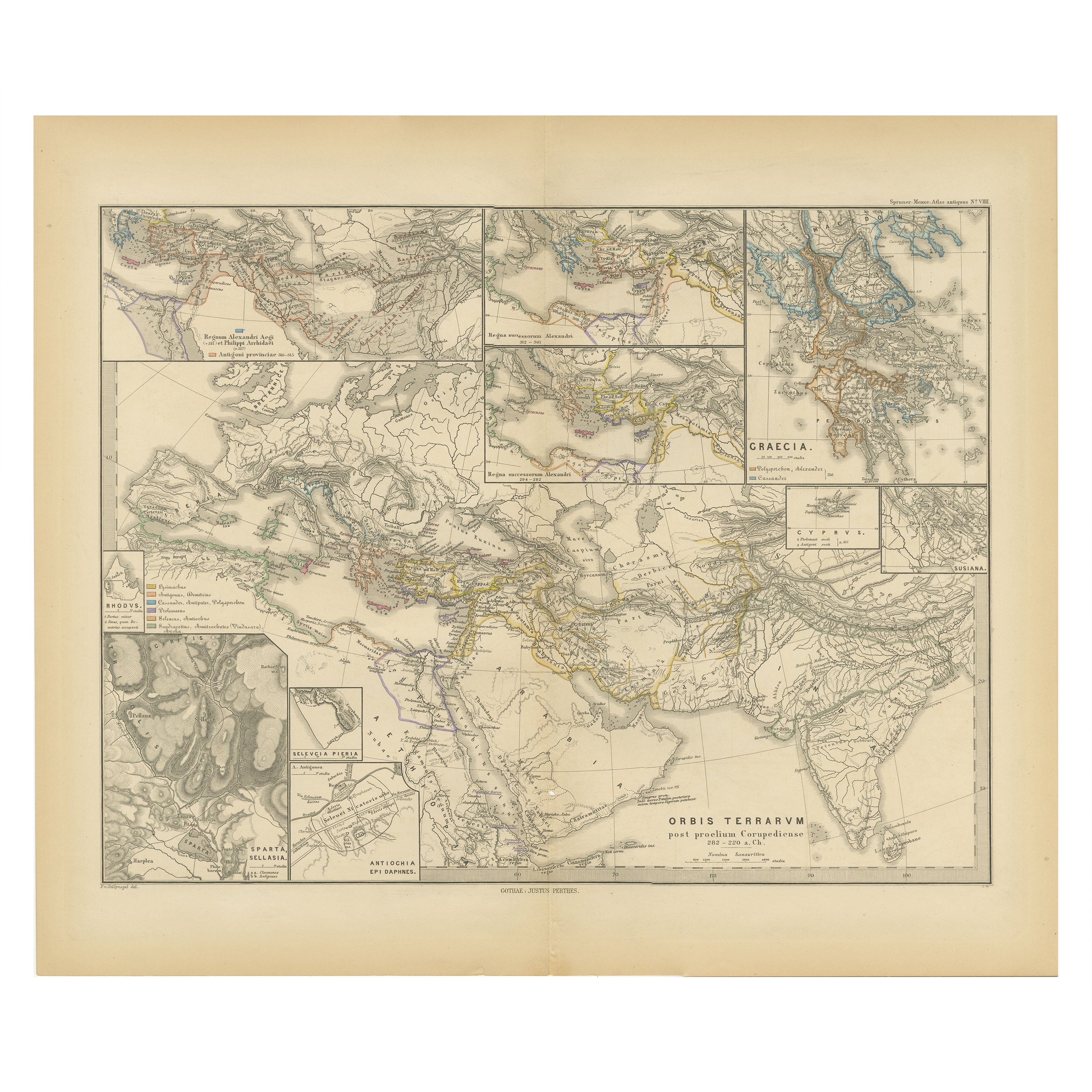
View AllThe World After the Battle of Corupedium: Hellenistic Kingdoms Map, 1880
Located in Langweer, NL
The map is titled "ORBIS TERRARUM post proelium Corupedinse," which translates to "The World after the Battle of Corupedium." This battle, which took place in 281 BC in Lydia, was th...
Category
Antique 1880s Maps
Materials
Paper
$354 Sale Price
20% Off
Free Shipping
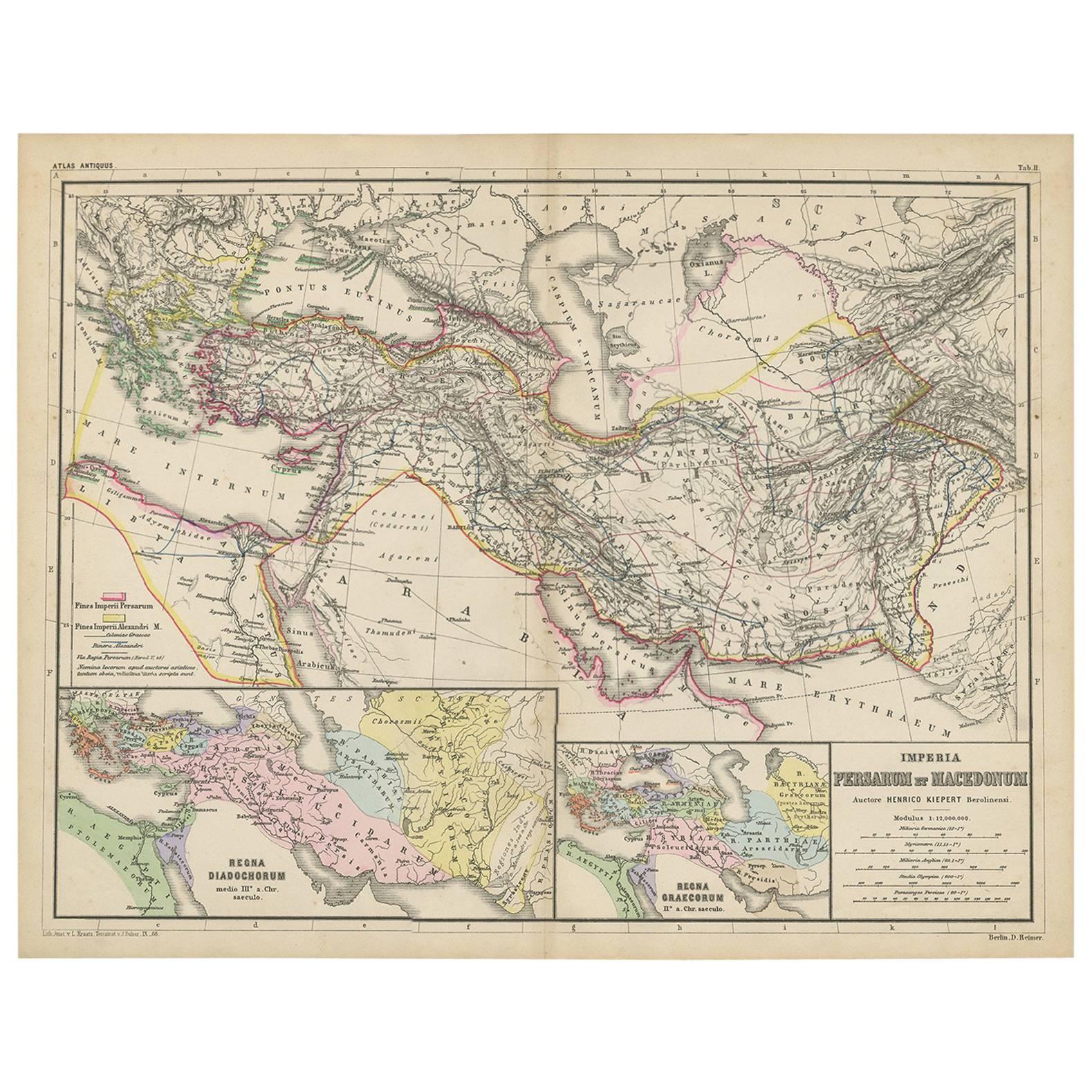
Antique Map of Part of the Roman Empire by H. Kiepert, circa 1870
By Heinrich Kiepert
Located in Langweer, NL
Antique map titled 'Imperia Persarum et Macedonum'. Depicts part of the Roman Empire, from Greece to Eastern India. This map originates from 'Atlas Antiqus. Zwölf Karten zur Alten Ge...
Category
Antique Late 19th Century Maps
Materials
Paper

$143 Sale Price
20% Off
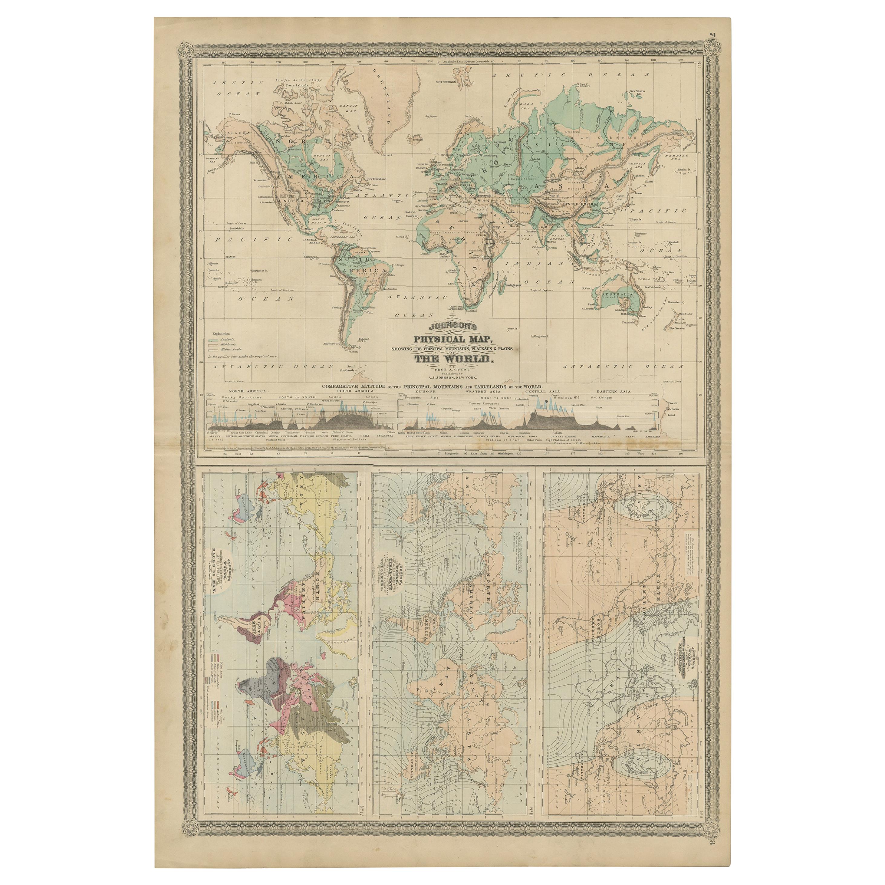
Four Physical Maps of the World on One Sheet , 1872
Located in Langweer, NL
Four physical maps of the world on one sheet. The upper map shows lowlands, highlands and highest lands. The other maps show world's races, ocean current and volcanoes, and magnetic ...
Category
Antique Late 19th Century Maps
Materials
Paper
$337 Sale Price
20% Off
Old Map of Mediterranean Powers: Pompey to Actium (66-31 BC), Published in 1880
Located in Langweer, NL
This is a historical map that depicts the Mediterranean region during a specific timeframe in Roman history, from the return of Pompey the Great after...
Category
Antique 1880s Maps
Materials
Paper
$354 Sale Price
20% Off
Free Shipping
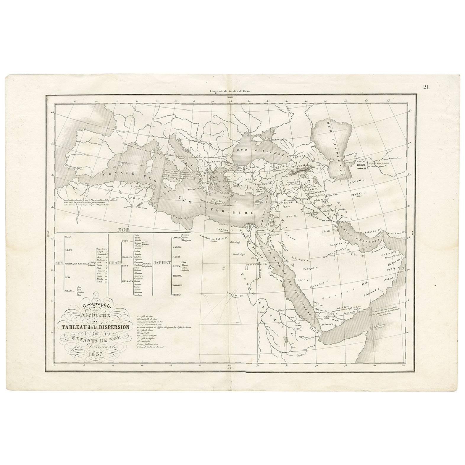
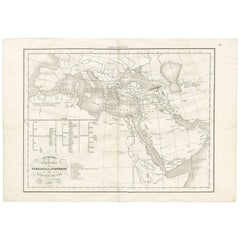
Géographie des Hébreux – Tableau de la Dispersion des Enfants de Noé, 1837
Located in Langweer, NL
Géographie des Hébreux – Tableau de la Dispersion des Enfants de Noé, 1837
This antique map, titled Géographie des Hébreux ou Tableau de la Dispersion des ...
Category
Antique Mid-19th Century French Maps
Materials
Paper
$231 Sale Price
20% Off
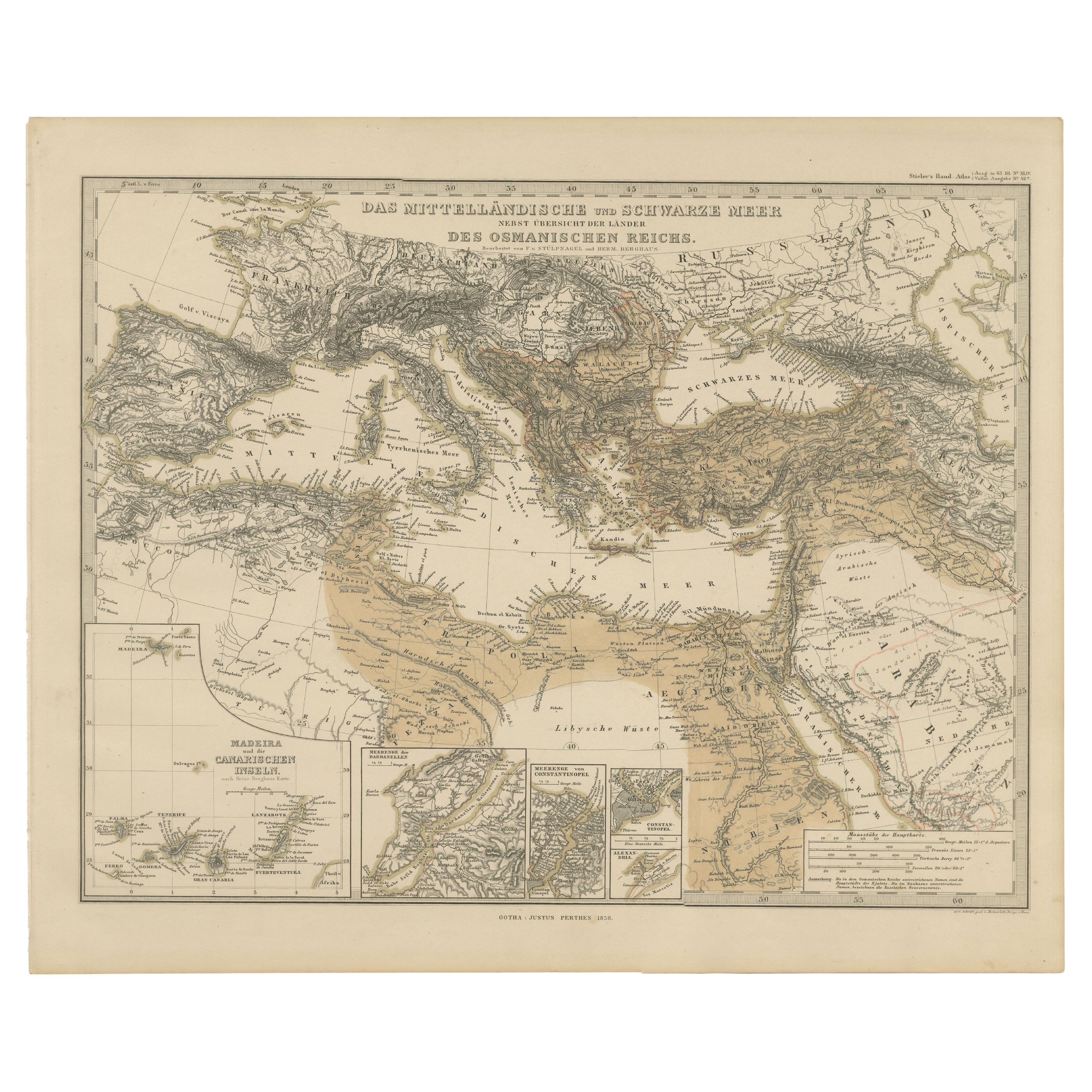
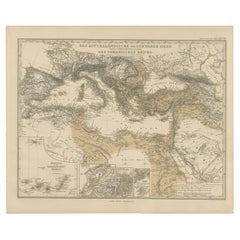
Mediterranean, Black Sea & Ottoman Empire Map 1853
Located in Langweer, NL
Mediterranean, Black Sea & Ottoman Empire Map 1853
This impressive antique print shows the Mediterranean and Black Sea regions with a focus on the Ottoman Empire, titled “Das Mittel...
Category
Antique Mid-19th Century German Maps
Materials
Paper
You May Also Like
Large Original Antique Map of The World, Fullarton, C.1870
Located in St Annes, Lancashire
Great map of the World. Showing both hemispheres
From the celebrated Royal Illustrated Atlas
Lithograph. Original color.
Published by Fullarton, Edinburgh, C.1870
Unframed.
Rep...
Category
Antique 1870s Scottish Maps
Materials
Paper

Original Antique Map of The World by Thomas Clerk, 1817
Located in St Annes, Lancashire
Great map of The Eastern and Western Hemispheres
On 2 sheets
Copper-plate engraving
Drawn and engraved by Thomas Clerk, Edinburgh.
Published by Mackenzie And Dent, 1817
...
Category
Antique 1810s English Maps
Materials
Paper

Original Antique Map of The Eastern Hemisphere by Dower, circa 1835
Located in St Annes, Lancashire
Nice map of the Eastern Hemisphere
Drawn and engraved by J.Dower
Published by Orr & Smith. C.1835
Unframed.
Free shipping
Category
Antique 1830s English Maps
Materials
Paper

Large Original Antique Map of The Greek Islands. 1894
Located in St Annes, Lancashire
Superb Antique map of The Greek Islands
Published Edward Stanford, Charing Cross, London 1894
Original colour
Good condition
Unframed.
Free shipping
Category
Antique 1890s English Maps
Materials
Paper

Original Antique Map of The World by Dower, circa 1835
Located in St Annes, Lancashire
Nice map of the World
Drawn and engraved by J.Dower
Published by Orr & Smith. C.1835
Unframed.
Free shipping
Category
Antique 1830s English Maps
Materials
Paper

Original Large Antique Map of Paris, France by John Dower, 1861
Located in St Annes, Lancashire
Fabulous monochrome map of Paris.
Vignettes of St Germain En Laye, Saint Cloud, Versailles and Fontainbleau.
Unframed.
Drawn by J.Dower.
Lithography by Weller. 4 sheets joined to...
Category
Antique 1860s English Victorian Maps
Materials
Paper

More Ways To Browse
Old World Furniture
19th Century Round Dining Table
Carved Chinese Tables
Mid Century Modern Danish Teak Dining Tables
Long Rug Runners
Pair Arm Chairs
Sterling Silver Dinner Sets
United Chair Company
British Antiques
Italian Beech Chairs
Shirvan Rugs
Spain Marble
Vintage Brown Bottles
Vintage Danish Tables And Chairs
1960s Glass Top Coffee Table
Black Glass Coffee Tables
Burnt Wood
Mid Century Wrought Iron Chairs