Mid-18th Century Maps
to
359
411
10
421
3
1
2,974
2,230
473
3
288
34
9
126
8
36
9
2
5
4
3
2
417
5
3
1
1
46
15
15
7
6
421
421
421
9
5
3
3
3
Period: Mid-18th Century
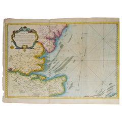
Map "Estuary- Mouth of the Thames"
Located in Alessandria, Piemonte
ST/426 - Antique French Map of the estuary of the Thames, map dated 1769 -
"Mape of the entrance of the Thames. Designed by filing of Navy cards fo...
Category
French Other Antique Mid-18th Century Maps
Materials
Paper
Recently Viewed
View AllMore Ways To Browse
Bavarian Porcelain Vases
Beer Tankard
Bjorn L
Black Cabinet With Flowers And Birds
Black Tansu Chest
Blue Morpho
Blue Opaline Crystal Vases
Bow Front Buffet
Boy And Girl Statues
Brass Donkey
Brass Hound
Bread Oven
Bronze Atlas Sculpture
Bronze Door Stop
Bronze Shakespeare Sculpture
Buddha Bell
Bull Terrier
Butlers Chest
