Items Similar to Rare 1730 Roman Empire Map by Moll - Detailed and Engraved Masterpiece

Want more images or videos?
Request additional images or videos from the seller
1 of 10
Rare 1730 Roman Empire Map by Moll - Detailed and Engraved Masterpiece
$1,343.08
$1,678.8520% Off
£999.12
£1,248.9020% Off
€1,120
€1,40020% Off
CA$1,839.14
CA$2,298.9220% Off
A$2,044.87
A$2,556.0920% Off
CHF 1,067.72
CHF 1,334.6520% Off
MX$24,891.04
MX$31,113.8020% Off
NOK 13,623.62
NOK 17,029.5220% Off
SEK 12,764.68
SEK 15,955.8520% Off
DKK 8,525.94
DKK 10,657.4320% Off
Shipping
Retrieving quote...The 1stDibs Promise:
Authenticity Guarantee,
Money-Back Guarantee,
24-Hour Cancellation
About the Item
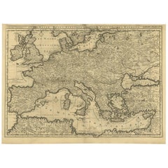
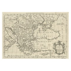
An Historical Map of the Roman Empire and the Neighbouring Barbarous Nations by Herman Moll - Circa 1730
This grand and historically significant map of the Roman Empire was created by the renowned cartographer Herman Moll around 1730. Entitled An Historical Map of the Roman Empire and the neighbouring Barbarous Nations to the Year of our Lord Four Hundred when the Empire began to be rent with foreign invasions, this large and meticulously engraved map showcases the vast extent of the Roman Empire at its height, as well as its neighboring territories inhabited by various so-called barbarous nations.
Moll’s map is based on a similar example by the French cartographer Guillaume De l'Isle, whose influence is acknowledged within the decorative title cartouche. The map is presented on two conjoined sheets and is impressively detailed, with careful outline coloring that emphasizes the political boundaries of the ancient world. The extensive annotations throughout the map reflect the cartographer’s dedication to historical accuracy and are packed with valuable insights and observations.
What makes this map particularly captivating are the two inset hemispherical maps located on either side of the main map. These supplementary maps depict the Eastern and Western hemispheres and are labeled Supplementum Theatro Historico. These insets add a global context to the Roman Empire’s dominance and illustrate how the ancient world perceived both the known and the unexplored parts of the Earth.
The map covers the vast Roman territory stretching from the British Isles and the Atlantic Ocean in the west to the Caspian Sea and Arabia in the east. It includes Europe, North Africa, and parts of Asia Minor and the Middle East. Geographical features such as mountains, rivers, and seas are finely engraved, while major ancient cities and provincial boundaries are clearly labeled. The inclusion of both ancient and contemporary names provides a fascinating insight into the evolution of geographic knowledge and place names over centuries.
The map itself carries the date 1709, but this does not necessarily indicate the actual publication date. Herman Moll originally created the map around 1709, but this version is more likely a later reissue from approximately 1730.
During this period, it was common for cartographers and publishers to reuse old plates for several decades, sometimes with slight updates or modifications, while keeping the original date on the map. In this case, the map was published by T. & J. Bowles, Philip Overton, and John King, who were active in the map publishing business during the early to mid-18th century, around the 1730s.
Therefore, the map was likely printed around 1730, although the original cartographic work by Herman Moll dates back to 1709. This practice of using older plates was practical and economical, and it also helped maintain the prestige associated with an earlier publication date.
Moll’s distinctive style is evident in the ornate cartouches, intricate border details, and the dense textual annotations that provide historical context about the Roman Empire’s expansion, administrative divisions, and interactions with neighboring tribes and kingdoms. This blend of visual appeal and scholarly content makes the map both an art piece and a historical document, capturing the imagination of scholars and collectors alike.
Condition: The map is in fair condition with contemporary outline coloring, old folds, slight creasing, and some staining, typical of a map of this age. The paper is sound, and the engraving remains clear and sharp.
Framing Tips: To best preserve this remarkable piece, use archival-quality materials and UV-protected glass to protect against fading. A classic, dark wood frame would elegantly enhance the historical ambiance of the map and highlight its exceptional cartographic detail.
More specific suggestions:
To enhance the visual appeal and historical feel of the map, consider using one of the following matting board colors:
1. Cream or Antique White: A classic choice that complements the aged paper and natural toning of antique maps. It gives a clean, elegant look while maintaining a vintage aesthetic.
2. Light Tan or Beige: These earthy tones harmonize with the yellowed or sepia tones often seen in old maps, giving a warm and sophisticated presentation.
3. Soft Gray: A subtle gray works well if the map has darker outline coloring, as it provides contrast without overpowering the map’s details.
4. Olive Green or Sage: If there is significant green coloring in the map, a muted green mat can enhance the natural landscape elements while still feeling classic and refined.
5. Dark Brown or Mahogany: These deeper shades create a rich, historic look and pair beautifully with traditional dark wood frames. This color enhances the cartouche and ornate details.
6. Burgundy or Wine Red: For a bold and distinguished appearance, burgundy adds a regal touch while complementing red-toned elements on the map.
Avoid bright or overly saturated colors, as they can distract from the map’s intricate details. Additionally, double matting with a narrow inner border in a contrasting color (such as gold or dark brown) can add depth and sophistication.
For this specific map by Herman Moll, a combination of a cream main mat with a thin dark brown or olive green inner mat would look particularly striking, balancing elegance with a sense of antiquity.
- Dimensions:Height: 22.25 in (56.5 cm)Width: 47.25 in (120 cm)Depth: 0.01 in (0.2 mm)
- Materials and Techniques:Paper,Engraved
- Period:1730-1739
- Date of Manufacture:circa 1730
- Condition:The map is in fair condition with contemporary outline coloring, old folds, slight creasing and some staining, typical of a map of this age. The paper is sound, and the engraving remains clear and sharp. Study the images carefully or ask more scans.
- Seller Location:Langweer, NL
- Reference Number:Seller: BG-138471stDibs: LU3054344168942
About the Seller
5.0
Recognized Seller
These prestigious sellers are industry leaders and represent the highest echelon for item quality and design.
Platinum Seller
Premium sellers with a 4.7+ rating and 24-hour response times
Established in 2009
1stDibs seller since 2017
2,511 sales on 1stDibs
Typical response time: <1 hour
- ShippingRetrieving quote...Shipping from: Langweer, Netherlands
- Return Policy
Authenticity Guarantee
In the unlikely event there’s an issue with an item’s authenticity, contact us within 1 year for a full refund. DetailsMoney-Back Guarantee
If your item is not as described, is damaged in transit, or does not arrive, contact us within 7 days for a full refund. Details24-Hour Cancellation
You have a 24-hour grace period in which to reconsider your purchase, with no questions asked.Vetted Professional Sellers
Our world-class sellers must adhere to strict standards for service and quality, maintaining the integrity of our listings.Price-Match Guarantee
If you find that a seller listed the same item for a lower price elsewhere, we’ll match it.Trusted Global Delivery
Our best-in-class carrier network provides specialized shipping options worldwide, including custom delivery.More From This Seller
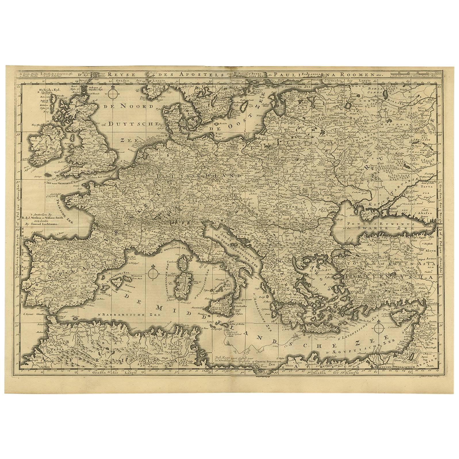
View AllRare Antique Bible Map of Southern Europe by A. Schut, 1743
Located in Langweer, NL
Antique map of the Mediterranean and a large part of Europe, illustrating the voyage of St. Paul to Rome. This map originates from ‘Biblia Sacra, dat is, de H. Schriftuer van het Oud...
Category
Antique Mid-18th Century Maps
Materials
Paper
$519 Sale Price
33% Off
Antique Map of Europe by Keizer & de Lat, 1788
Located in Langweer, NL
Antique map titled 'Kaartje van Europa (..)'. Uncommon original antique map of Europe. This map originates from 'Nieuwe Natuur- Geschied- en Handelkundige Zak- en Reisatlas' by Gerri...
Category
Antique Late 18th Century Maps
Materials
Paper

$383 Sale Price
20% Off
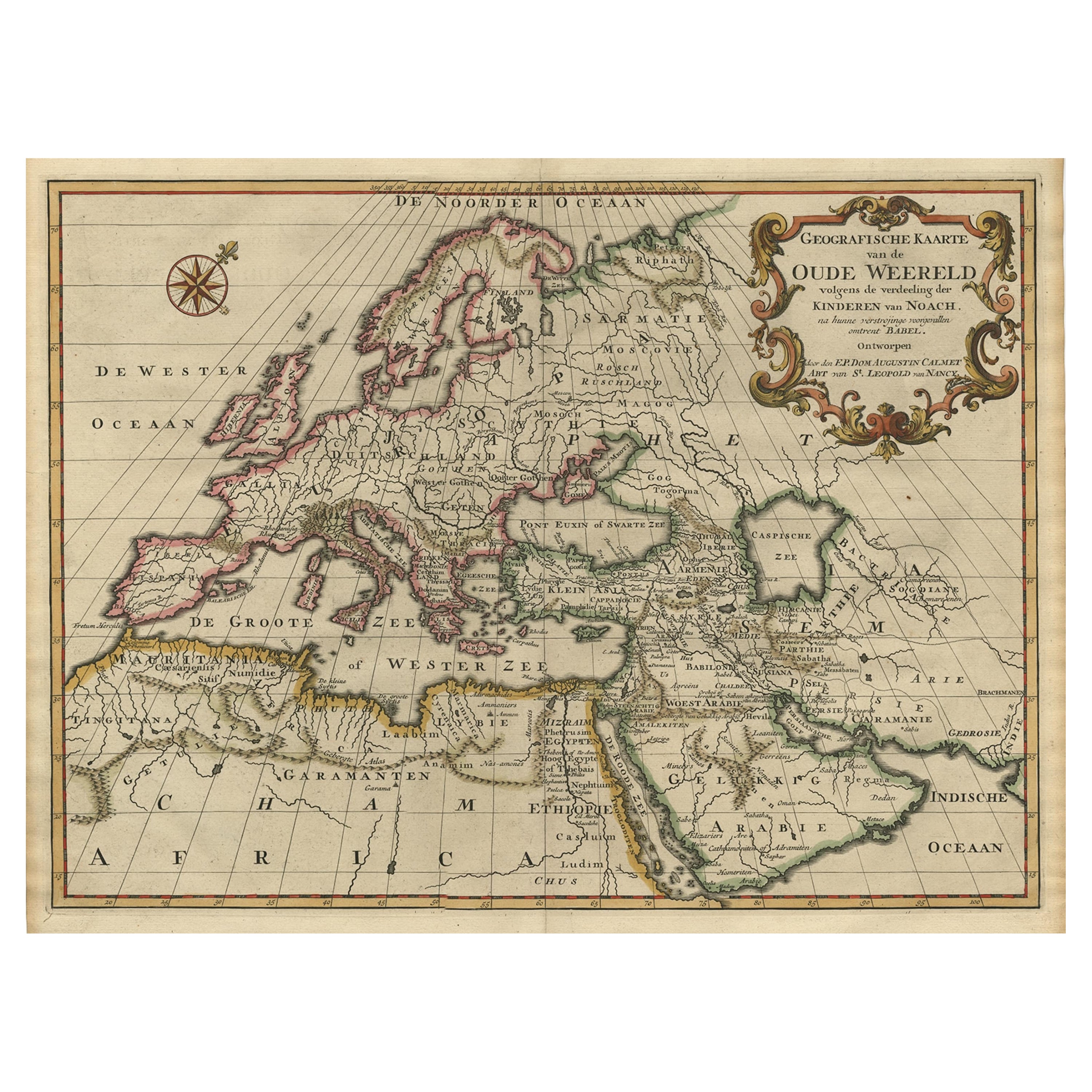
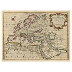
Ancient World Map of Europe, Asia & Northern Africa with Ancient Names, 1725
Located in Langweer, NL
Antique map titled 'Geografische Kaarte van de Oude Weereld (..).'
Original antique map of the ancient world depicting Europe, Asia, and northern Africa with ancient place names....
Category
Antique 1720s Maps
Materials
Paper
$1,124 Sale Price
24% Off
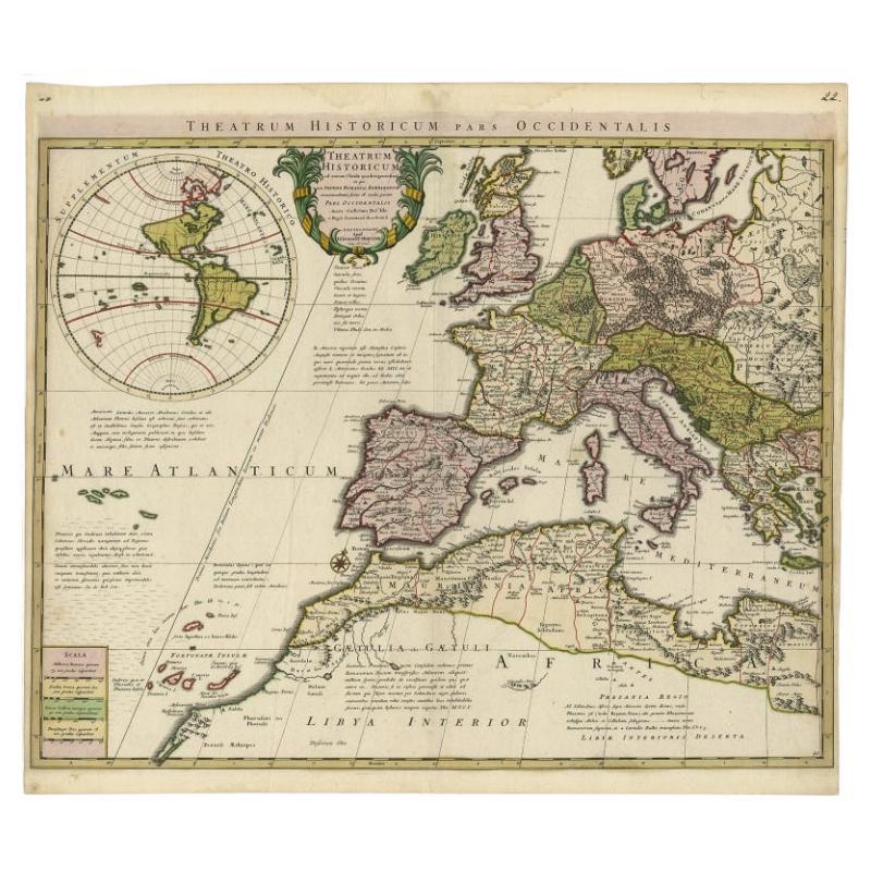
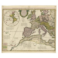
Finely Engraved Antique Map of Europe with inset of America, c.1745
By Guillaume De L'Isle
Located in Langweer, NL
Antique map titled 'Theatrum Historicum pars Occidentalis.' Finely engraved historical map with a profusion of details. It shows western Europe and the northern Mediterranean basin a...
Category
Antique 18th Century Maps
Materials
Paper
$1,391 Sale Price
20% Off
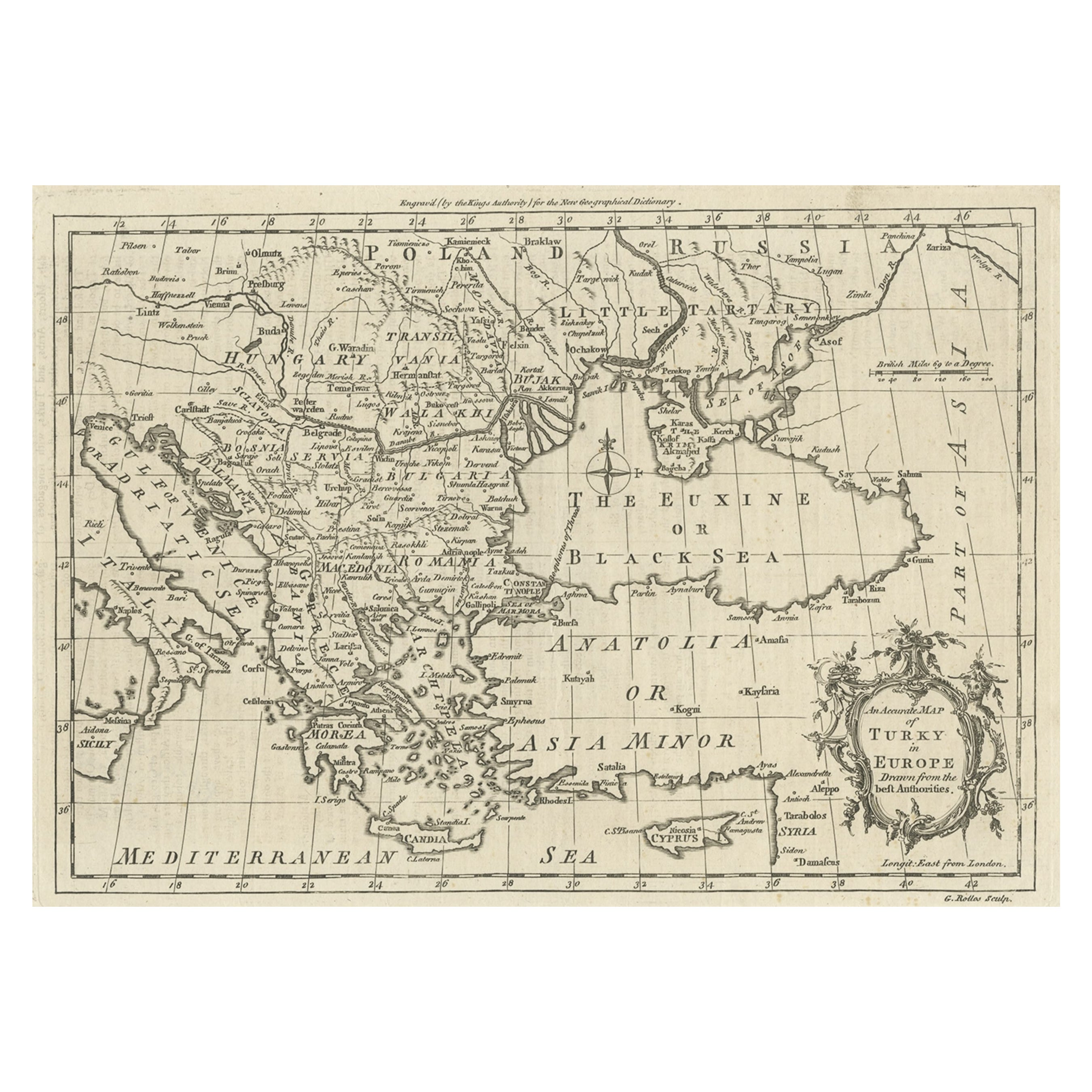
Map of the Ottoman Empire in Europe, incl. the Balkans, Greece & Turkey, c.1760
Located in Langweer, NL
Antique map Turkey titled 'An Accurate Map of Turky in Europe drawn from the best Authorities'.
Map of the Ottoman Empire in Europe, the Balkans, Greece, and Turkey in Europe. Engr...
Category
Antique 1760s Maps
Materials
Paper
$441 Sale Price
20% Off
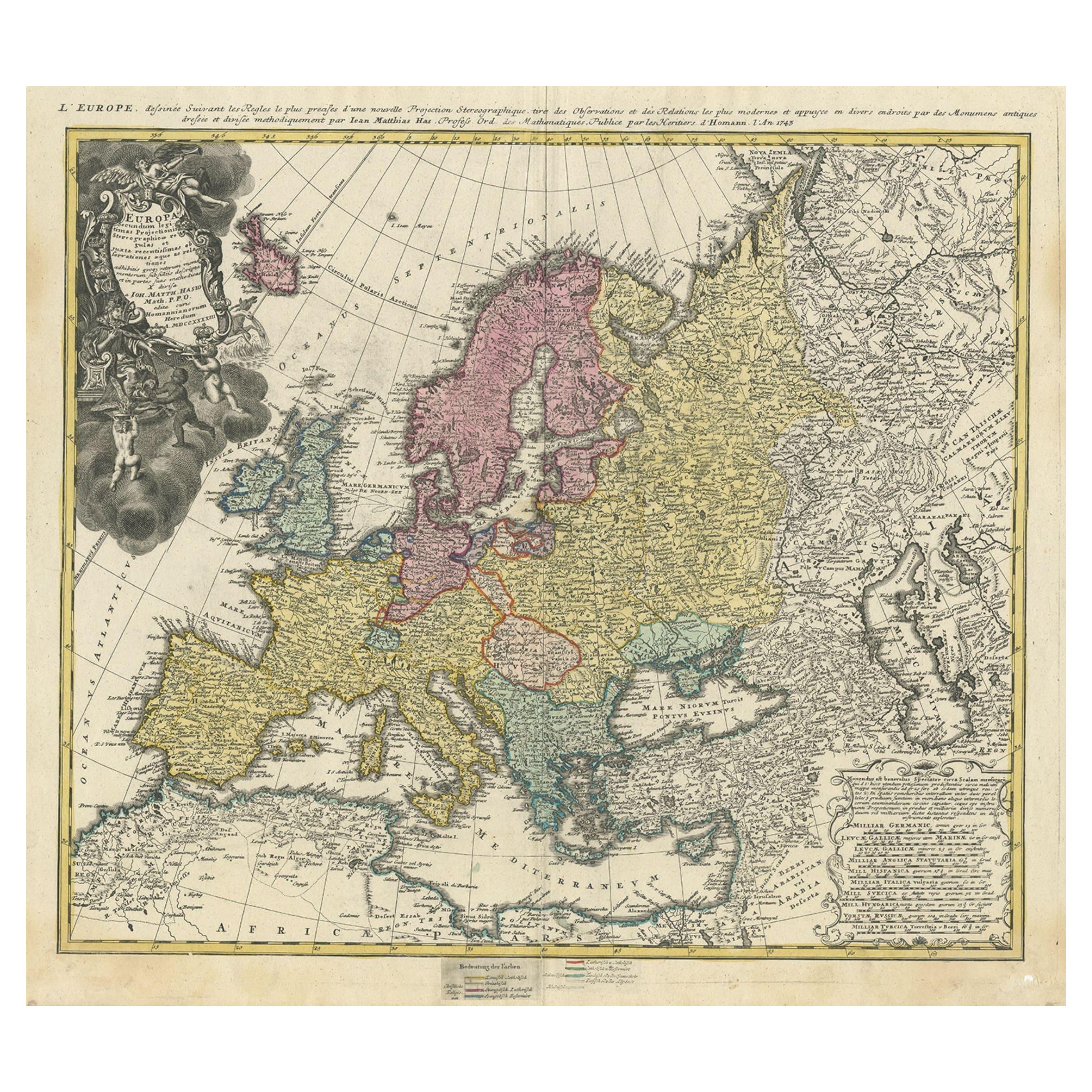
Antique Map of Europe with Elaborate Title Cartouche, c.1750
Located in Langweer, NL
Antique map of Europe titled 'Europa Secundum legitimas Projectionis Stereographicae regulas et juxta recentissimas observationes aeque ac relationes… - L'Europe, dessinee suivant le...
Category
Antique 18th Century Maps
Materials
Paper
$623 Sale Price
20% Off
You May Also Like
1718 Ides & Witsen Map "Route D'amsterdam a Moscow Et De La Ispahan Et Gamron
Located in Norton, MA
1718 Ides & Witsen map, entitled
"Route D'Amsterdam A Moscow Et De La Ispahan Et Gamron,"
Ric.b005
Subject: Eastern Europe and Central Asia
Period: 1718 (published)
Publicati...
Category
Antique Early 18th Century Dutch Maps
Materials
Paper

Original Antique Map of Europe, Arrowsmith, 1820
Located in St Annes, Lancashire
Great map of Europe
Drawn under the direction of Arrowsmith.
Copper-plate engraving.
Published by Longman, Hurst, Rees, Orme and Brown, 1820
...
Category
Antique 1820s English Maps
Materials
Paper

Large Original Antique Map of Europe by Sidney Hall, 1847
Located in St Annes, Lancashire
Great map of Europe
Drawn and engraved by Sidney Hall
Steel engraving
Original colour outline
Published by A & C Black. 1847
Unframed
Free shipping.
Category
Antique 1840s Scottish Maps
Materials
Paper

Southern & Eastern Europe: A Large 17th C. Hand-colored Map by Sanson & Jaillot
By Nicolas Sanson
Located in Alamo, CA
This large hand-colored map entitled "Estats de L'Empire des Turqs en Europe, ou sont les Beglerbeglicz our Gouvernements" was originally created by Nicholas Sanson d'Abbeville and t...
Category
Antique 1690s French Maps
Materials
Paper

1790 Thomas Stackhouse Map, Entitled "Russia in Europe, " , Ric.a004
Located in Norton, MA
1790 Thomas Stackhouse map, entitled
"Russia in Europe"
Ric.a004
Stackhouse, Thomas
Russia in Europe [map]
London: T. Stackhouse, 1783. Map. Matted hand-colored copper engraving. Image size: 14.5 x 15.25 inches. Mat size: 22.75 x 23.75 inches. A beautiful example of this map of Eastern Europe...
Category
Antique 17th Century Unknown Maps
Materials
Paper

17th Century Nicolas Visscher Map of Southeastern Europe
Located in Hamilton, Ontario
A beautiful, highly detailed map of southeastern Europe by Nicolas Visscher. Includes regions of Northern Italy (showing the cities Bologna, Padua, and Venice), Bohemia, Austria (sho...
Category
Antique 17th Century Dutch Maps
Materials
Paper

$1,350 Sale Price
38% Off
More Ways To Browse
Map Case
French Wine Map
French Matting
Antique Wine Labels
Yellow Wine Glass
Renting Antique Furniture
Burgundy Bowl
Antique Map Case
Red And Gold Wine Glasses
Philip North
Middle Eastern Plate
Burgundy Wine Glasses
Olive Green Glass Bowl
Sepia Engraving
Vintage Scandanavian Chairs
19th Century Red Glass
Antique French Console Table Tables
Silver Bowl Large