Items Similar to Rare 1864 Civil War Era Map of North America with Detailed Borders


Want more images or videos?
Request additional images or videos from the seller
1 of 10
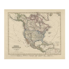
Rare 1864 Civil War Era Map of North America with Detailed Borders
$512.46
£388.20
€440
CA$709.95
A$796.26
CHF 416.99
MX$9,675.29
NOK 5,295.04
SEK 5,020.07
DKK 3,350.06
About the Item
Title: Rare 1864 Civil War Era Map of North America with Detailed Borders
Description: This remarkable antique map, titled "Johnson's North America," was published in 1864 by Johnson and Ward, a celebrated American mapmaking firm known for their precise and visually stunning atlases during the mid-19th century.
The map provides a comprehensive view of North America, encompassing the United States, Canada, Mexico, and parts of Central America and the Caribbean, with detailed delineations of states, territories, and geographical features. Regions are outlined in a vibrant pink, with a soft green wash filling the background, creating a visually appealing contrast that highlights the continent’s topography. A decorative border frames the map, adding to its antique elegance, while the map includes notable geographical markers such as the Great Lakes, the Rocky Mountains, and the Gulf of Mexico.
The map was crafted using the steel engraving technique, renowned for its precision and ability to produce fine lines and intricate details, as evident in the crisp text and delicate linework.
What makes this map particularly fascinating is its historical context—produced during the Civil War, it captures North America at a time of significant political upheaval, reflecting the United States’ division and the evolving boundaries of its territories. The map also provides a glimpse into the colonial and territorial claims of the era, including British-controlled Canada and the newly acquired western territories of the U.S. Collectors and historians will value this map for its ability to transport viewers to a transformative period in North American history, blending functional cartography with artistic beauty, making it a prized addition to any collection of antique maps or Americana.
Condition Report: The map is in good condition for its age, with light toning and minor foxing along the edges. Small tears are present at the fold lines, and right margins but there are no significant losses. The colors remain vivid, and the paper is intact with slight wear.
Framing Tips: Use an acid-free mat to prevent discoloration and UV-protective glass to shield from light damage. A soft ivory or off-white matting board is recommended, as it complements the aged cream tone of the map’s paper, creating a cohesive and elegant look. This neutral color allows the pink and green hues to stand out without distraction, maintaining a classic, museum-quality presentation that appeals to collectors. It also enhances the map’s historical charm by blending seamlessly with its vintage appearance.
For a subtle contrast, a pale taupe could also work, adding a hint of warmth while keeping the focus on the map’s details. Avoid bold or dark colors. A classic wooden frame with a gold accent enhances the map’s vintage charm. Avoid tight pressing to reduce stress on the folds.
- Dimensions:Height: 26.38 in (67 cm)Width: 18 in (45.7 cm)Depth: 0.01 in (0.2 mm)
- Materials and Techniques:
- Period:
- Date of Manufacture:1864
- Condition:The map is in good condition for its age, with light toning and minor foxing along the edges. Small tears are present at the fold lines, and right margins but there are no significant losses. The colors remain vivid, and the paper is intact.
- Seller Location:Langweer, NL
- Reference Number:Seller: BG-13952-171stDibs: LU3054345073962
About the Seller
5.0
Recognized Seller
These prestigious sellers are industry leaders and represent the highest echelon for item quality and design.
Platinum Seller
Premium sellers with a 4.7+ rating and 24-hour response times
Established in 2009
1stDibs seller since 2017
2,517 sales on 1stDibs
Typical response time: <1 hour
- ShippingRetrieving quote...Shipping from: Langweer, Netherlands
- Return Policy
Authenticity Guarantee
In the unlikely event there’s an issue with an item’s authenticity, contact us within 1 year for a full refund. DetailsMoney-Back Guarantee
If your item is not as described, is damaged in transit, or does not arrive, contact us within 7 days for a full refund. Details24-Hour Cancellation
You have a 24-hour grace period in which to reconsider your purchase, with no questions asked.Vetted Professional Sellers
Our world-class sellers must adhere to strict standards for service and quality, maintaining the integrity of our listings.Price-Match Guarantee
If you find that a seller listed the same item for a lower price elsewhere, we’ll match it.Trusted Global Delivery
Our best-in-class carrier network provides specialized shipping options worldwide, including custom delivery.More From This Seller
View All1874 Map of the United States with Territorial Boundaries
Located in Langweer, NL
Title: 1874 Map of the United States with Territorial Boundaries
Description: This is an 1874 map titled "Map of the United States," showcasing the country during a period of rapid ...
Category
Antique 1870s Maps
Materials
Paper
$242 Sale Price
20% Off
Antique Map of North America by Johnson, '1872'
Located in Langweer, NL
Antique map titled 'Johnson's North America'. Original map of North America, with an inset map of the Hawaiian group or Sandwich Islands. This map originates from 'Johnson's New Illu...
Category
Antique Late 19th Century Maps
Materials
Paper

$372 Sale Price
20% Off
Antique Map of the United States of North America, c.1882
Located in Langweer, NL
Antique map titled 'United States of North America'. Old map of the United States of North America. This map originates from 'The Royal Atlas of Modern Geography, Exhibiting, in a Se...
Category
Antique 1880s Maps
Materials
Paper

$326 Sale Price
20% Off
Old Original Antique German Map of North America, ca.1870
Located in Langweer, NL
Antique map titled 'Nord-America'.
Old map of North America. This map originates from 'H. Kiepert's Kleiner Atlas der Neueren Geographie für Schule und Haus'.
Artists and Engrave...
Category
Antique 1870s Maps
Materials
Paper

$456 Sale Price
20% Off
United States, Canada & Mexico – 1857 North America Map
Located in Langweer, NL
North America Map – United States, Canada, Mexico 1857
This impressive antique print shows “Nord-America” meaning “North America,” published in 1857 by Justus Perthes in Gotha as pa...
Category
Antique Mid-19th Century German Maps
Materials
Paper
Antique Map of North America by A & C. Black, 1870
Located in Langweer, NL
Antique map titled 'North America'. Original antique map of North America. This map originates from ‘Black's General Atlas of The World’. Published by A & C. Black, 1870.
Category
Antique Late 19th Century Maps
Materials
Paper

$256 Sale Price
20% Off
You May Also Like
North America. Century Atlas antique vintage map
Located in Melbourne, Victoria
'The Century Atlas. North America'
Original antique map, 1903.
Central fold as issued. Map name and number printed on the reverse corners.
Sheet 40cm by 29.5cm.
Category
Early 20th Century Victorian More Prints
Materials
Lithograph

Original Antique Map of The United States of America by Dower, circa 1835
Located in St Annes, Lancashire
Nice map of the USA
Drawn and engraved by J.Dower
Published by Orr & Smith. C.1835
Unframed.
Free shipping
Category
Antique 1830s English Maps
Materials
Paper

Large Original Vintage Map of North America, circa 1920
Located in St Annes, Lancashire
Great map of North America
Original color. Good condition
Published by Alexander Gross
Unframed.
Category
Vintage 1920s English Edwardian Maps
Materials
Paper

Original Antique Map of North America by Dower, circa 1835
Located in St Annes, Lancashire
Nice map of North America
Drawn and engraved by J.Dower
Published by Orr & Smith. C.1835
Unframed.
Free shipping
Category
Antique 1830s English Maps
Materials
Paper

Original Antique Map of United States, Grattan and Gilbert, 1843
Located in St Annes, Lancashire
Great map of United States
Drawn and engraved by Archer
Published by Grattan and Gilbert. 1843
Original colour
Unframed.
Category
Antique 1840s English Maps
Materials
Paper

1864 Map of North America, Antique Hand-Colored Map, by Adolphe Hippolyte Dufour
Located in Colorado Springs, CO
Offered is a map of North America entitled Amerique du Nord from 1864. This rare, separately published wall map was produced by Adolphe Hippolyte Dufour. This map includes vibrant an...
Category
Antique 1860s French Maps
Materials
Paper

More Ways To Browse
Canada Antiques
Antique Ivory Collectables
Antique Wash Stand
Silver Bowl Large
Down Couch
Used Lighter Art
Blue Edge Glass
Mahogany 1950s Furniture
Solid Mahogany Table
Dessert Glasses
Geometric Glass Table
Mid Century Pin
6x10 Rug
Studded Furniture
Styles Of Antique Desks
Black And White Coffee Table
Metal Relief
Curved Velvet Couch