Items Similar to Texas California Mexico Map – Antique Tallis Map with Gold Region, c.1850


Want more images or videos?
Request additional images or videos from the seller
1 of 10
Texas California Mexico Map – Antique Tallis Map with Gold Region, c.1850
$791.39
£594.61
€670
CA$1,089.75
A$1,219.63
CHF 638.43
MX$14,816.27
NOK 8,106.46
SEK 7,649.83
DKK 5,099.37
About the Item
Texas California Mexico Map – Antique Tallis Map with Gold Region, c.1850
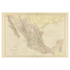
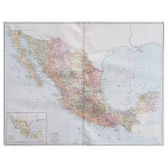
This highly decorative and historically rich map titled 'Mexico, California and Texas' was published around 1850 by John Tallis & Company, London and New York, and engraved by J. Rapkin. It offers an extraordinary visual snapshot of North America during a transformative era, particularly in the years following the Mexican-American War (1846–1848).
One of the most notable features is the depiction of Texas in its Republic-era boundaries, including the dramatic stovepipe extension reaching north toward present-day Wyoming and Colorado. To the west, Upper California is presented with gold regions clearly marked, highlighting the intense interest surrounding the 1849 Gold Rush. This is further emphasized by the inclusion of the Gold Washing vignette in the lower left, a detailed engraving that is absent in earlier editions of this map.
The political boundaries show a pre-Gadsden Purchase border, offering an important view of U.S.-Mexico relations before the southern Arizona lands were acquired. The map also names numerous Native American tribes across the Southwest and northern Mexico, giving it additional ethnographic value. Early forts, outposts, and emigration trails are marked throughout Texas and the western territories, including parts of Arizona, New Mexico, and California.
Surrounding the map are finely engraved vignettes including:
Gold Washing (California),
Mexican Peasantry (lower left),
Ruins at Uxmal, Yucatan (upper right).
These illustrations by H. Warren and engraver J. Rogers enrich the visual narrative and underscore the map’s dual function as both a geographic tool and a decorative print.
This map was originally published in *The History and Topography of the United States of America* edited by John Howard Hinton. Tallis maps are widely admired for their aesthetic borders and rich historical content, making them highly collectible.
Condition report:
Excellent condition with original outline color. Light age toning and minor edge wear. No tears or repairs. Vignettes and borders are sharp and well preserved.
Framing tips:
Frame with a dark wood or antique gold moulding and use an off-white or parchment-colored mat to complement the map’s tones. UV-protective glass recommended to preserve the hand-color and engraved detail.
- Dimensions:Height: 10.44 in (26.5 cm)Width: 13.78 in (35 cm)Depth: 0.02 in (0.5 mm)
- Materials and Techniques:Paper,Engraved
- Period:
- Date of Manufacture:circa 1850
- Condition:Excellent condition with original outline color. Light age toning and minor edge wear. No tears or repairs. Vignettes and borders are sharp and well preserved.
- Seller Location:Langweer, NL
- Reference Number:Seller: BG-13999-551stDibs: LU3054345132642
About the Seller
5.0
Recognized Seller
These prestigious sellers are industry leaders and represent the highest echelon for item quality and design.
Platinum Seller
Premium sellers with a 4.7+ rating and 24-hour response times
Established in 2009
1stDibs seller since 2017
2,534 sales on 1stDibs
Typical response time: <1 hour
- ShippingRetrieving quote...Shipping from: Langweer, Netherlands
- Return Policy
Authenticity Guarantee
In the unlikely event there’s an issue with an item’s authenticity, contact us within 1 year for a full refund. DetailsMoney-Back Guarantee
If your item is not as described, is damaged in transit, or does not arrive, contact us within 7 days for a full refund. Details24-Hour Cancellation
You have a 24-hour grace period in which to reconsider your purchase, with no questions asked.Vetted Professional Sellers
Our world-class sellers must adhere to strict standards for service and quality, maintaining the integrity of our listings.Price-Match Guarantee
If you find that a seller listed the same item for a lower price elsewhere, we’ll match it.Trusted Global Delivery
Our best-in-class carrier network provides specialized shipping options worldwide, including custom delivery.More From This Seller
View All1882 Antique Map of Mexico Highlighting Geographical and Political Boundaries
Located in Langweer, NL
This 1882 map of Mexico, published by Blackie and Son as part of the 'Comprehensive Atlas and Geography of the World,' provides a highly detailed representation of the country's geog...
Category
Antique 1880s Maps
Materials
Paper
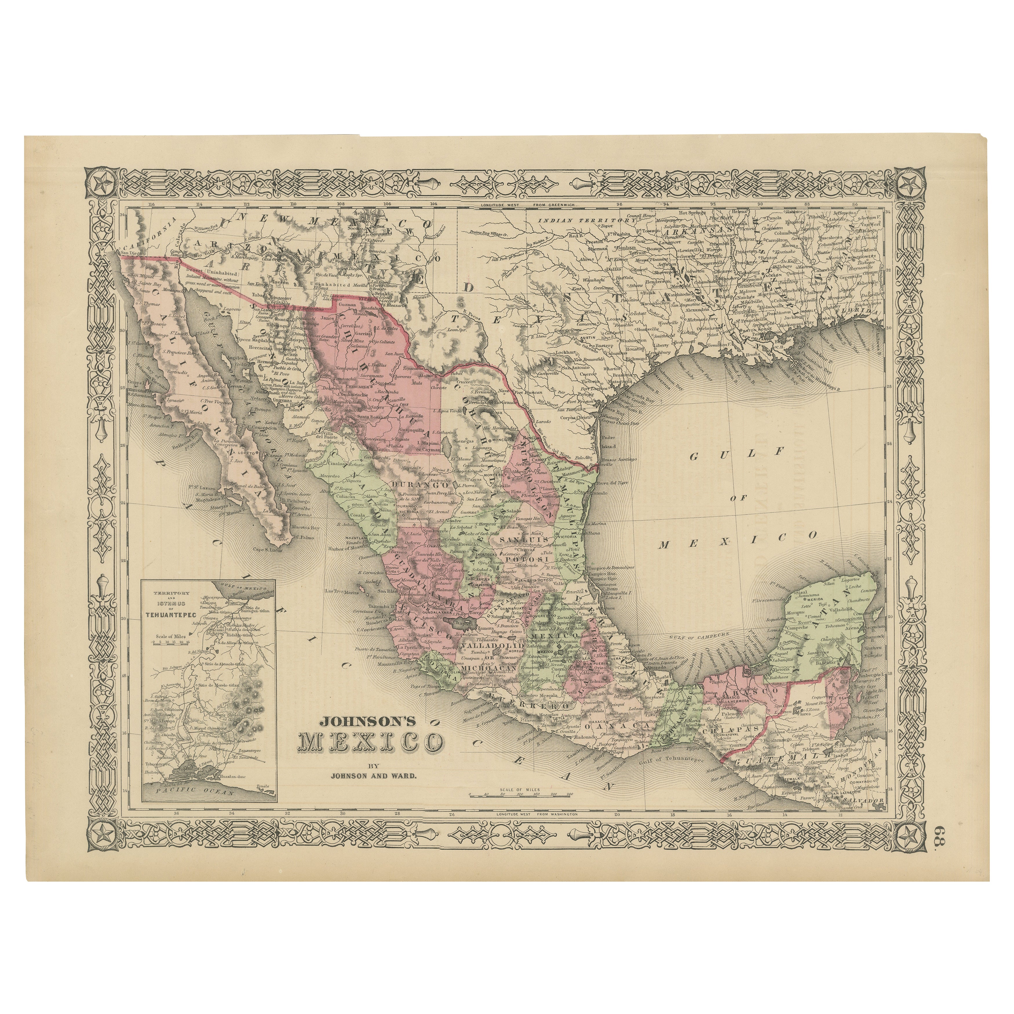
Johnson’s Mexico Map with Tehuantepec Inset, USA c.1864 – Hand-Colored
Located in Langweer, NL
Johnson’s Mexico Map with Tehuantepec Inset, USA c.1864 – Hand-Colored
This is a finely engraved and hand-colored map titled Johnson’s Mexico, published by Johnson and Ward in New Y...
Category
Antique Mid-19th Century American Maps
Materials
Paper
Antique Map of Mexico and Central America by Johnson '1872'
Located in Langweer, NL
Antique map titled 'Johnson's Mexico (..)'. Two maps one one sheet showing Mexico and Central America, with inset maps of Tehuantepec and Panama. This map originates from 'Johnson's ...
Category
Antique Late 19th Century Maps
Materials
Paper

$283 Sale Price
20% Off
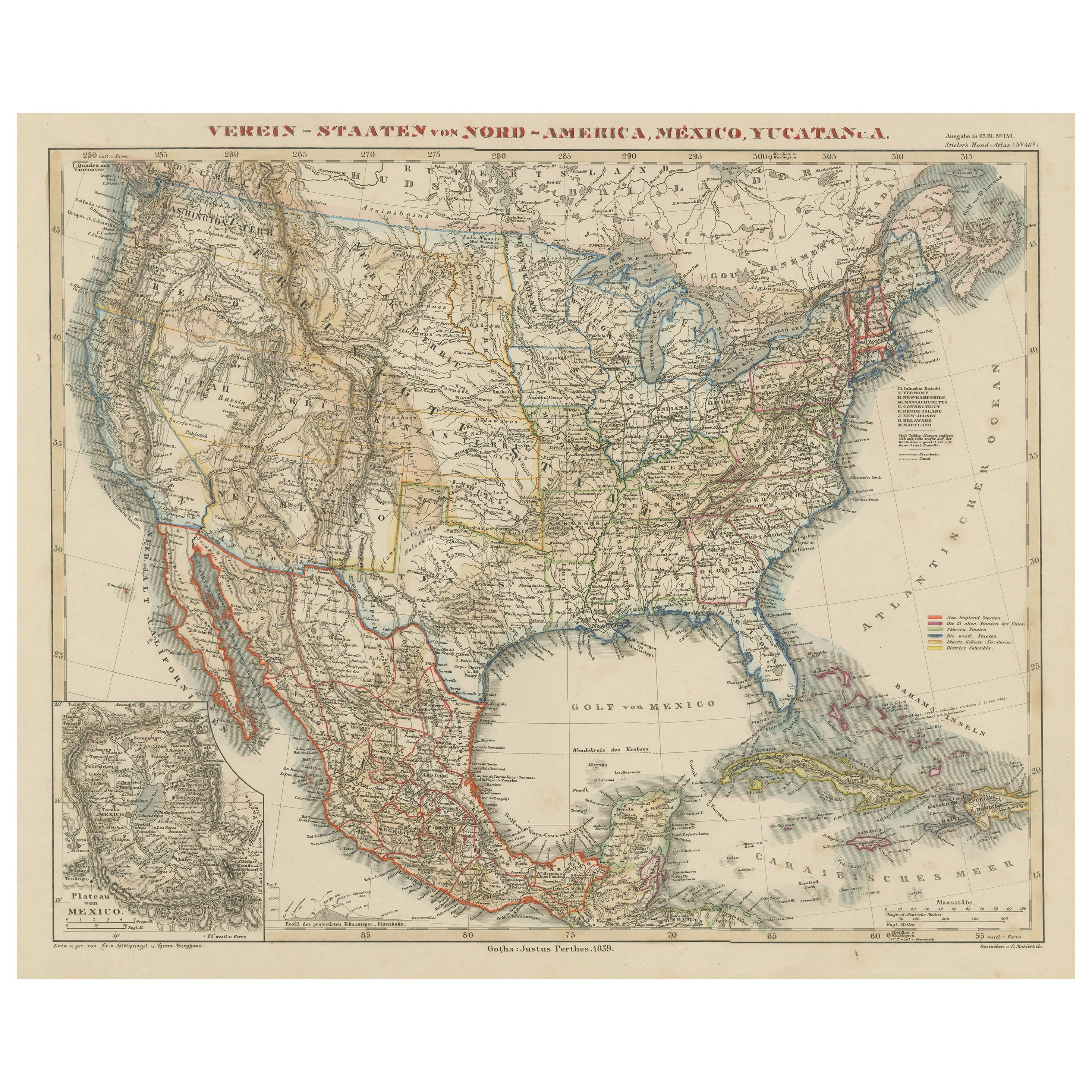
Antique Map of the United States with inset map of the region of Mexico City
Located in Langweer, NL
Antique map titled 'Verein-Staaten von Nord-America, Mexico, Yucatan u.a.'. Very detailed map of the United States of America showing the Caribbean. With an inset map of the surround...
Category
Antique Mid-19th Century Maps
Materials
Paper

$812 Sale Price
20% Off
Old Original Antique German Map of North America, ca.1870
Located in Langweer, NL
Antique map titled 'Nord-America'.
Old map of North America. This map originates from 'H. Kiepert's Kleiner Atlas der Neueren Geographie für Schule und Haus'.
Artists and Engrave...
Category
Antique 1870s Maps
Materials
Paper

$463 Sale Price
20% Off
Antique Map of Mexico by Johnston, '1909'
Located in Langweer, NL
Antique map titled 'Mexico'. Original antique map of Mexico. This map originates from the ‘Royal Atlas of Modern Geography’. Published by W. & A....
Category
Early 20th Century Maps
Materials
Paper
$236 Sale Price
20% Off
You May Also Like
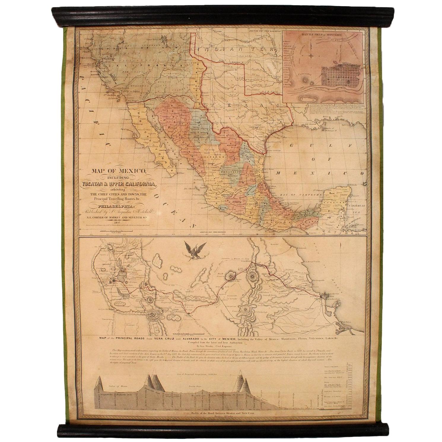
1847 Antique Map of Mexico, Texas and California by Samuel Augustus Mitchell
By Samuel Augustus Mitchell 1
Located in Colorado Springs, CO
Presented is the second edition of Samuel Augustus Mitchell's Map of Mexico, Including Yucatan & Upper California, an important map showing the progress of the Mexican-American War. ...
Category
Antique 1840s American Maps
Materials
Paper

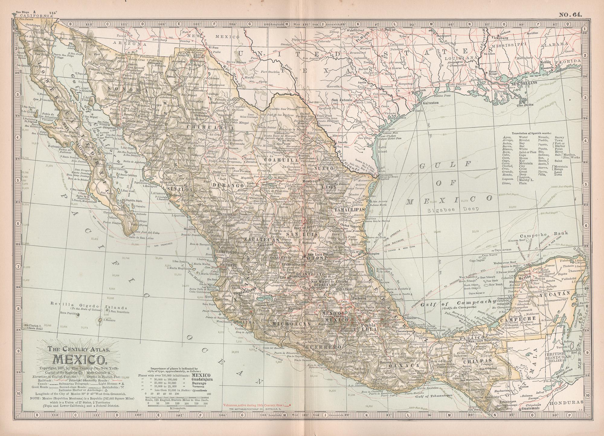
Mexico. Century Atlas antique vintage map
Located in Melbourne, Victoria
'The Century Atlas. Mexico.'
Original antique map, 1903.
Central fold as issued. Map name and number printed on the reverse corners.
Sheet 29.5cm by 40cm.
Category
Early 20th Century Victorian More Prints
Materials
Lithograph

Ancient Map of Mexico - Original Etching - 19th Century
Located in Roma, IT
This Map of Mexico is an etching realized in 19th century.
The state of preservation of the artwork is good with some small missing papers on the right angles. At the top of the pap...
Category
19th Century More Prints
Materials
Etching
Large Original Vintage Map of Mexico, circa 1920
Located in St Annes, Lancashire
Great map of Mexico
Original color.
Good condition
Published by Alexander Gross
Unframed.
Category
Vintage 1920s English Edwardian Maps
Materials
Paper
1847 Ornamental Map of the United States & Mexico by H. Phelps
Located in Colorado Springs, CO
Offered is an original 1847 ornamental map of the U.S. entitled "Ornamental Map of the United States & Mexico" by Humphrey Phelps. The map was issued as an act of Congress by Phelps on Fulton Street, New York. The broadside is elaborately hand-colored.
This is a very detailed and graphic propaganda map of the United States expressing U.S. dominance of the North American continent. The hand-colored map proclaims the Manifest Destiny, with the recent acquisition of Upper California and Texas at the conclusion of the Mexican-American War. The newly acquired land is boldly colored, standing in stark contrast to the rest of the U.S. The map details a potential route for a railroad running from New York City, to Buffalo, to Chicago, then west along the Oregon Trail to Oregon City. This route anticipates the construction of the transcontinental railroad by nearly 20 years.
The map includes elaborately detailed renderings of George Washington, Hernan Cortez, and Montezuma at top to represent European expansion to the Americas. At bottom are four inset designs with text showing the following: a chronological history of the U.S. beginning from settlement to the U.S. victory in the Mexican-American war; an illustration of General Zachary Taylor with details on the Oregon Territory; an illustration of the Aztec Temple of the Sun in Tenochtitlan and a chronology of the Conquest of the Aztec Empire under Cortez; a portrait of General Antonio Lopez de Santa Anna...
Category
Antique 1840s American Maps
Materials
Paper

Original Antique Map of North America by Dower, circa 1835
Located in St Annes, Lancashire
Nice map of North America
Drawn and engraved by J.Dower
Published by Orr & Smith. C.1835
Unframed.
Free shipping
Category
Antique 1830s English Maps
Materials
Paper

More Ways To Browse
Used Furniture In Texas
Early California Furniture
Mexican Antiques
Antique Furniture California
Early Texas Furniture
19th Century Mexican Furniture
Antique Engraving Tools
Antique Rogers
J Hinton
Solid Mahogany Table
Dessert Glasses
Geometric Glass Table
Mid Century Pin
6x10 Rug
Studded Furniture
Styles Of Antique Desks
Black And White Coffee Table
Metal Relief