Items Similar to Antique Map of the United States with inset map of the region of Mexico City


Want more images or videos?
Request additional images or videos from the seller
1 of 6
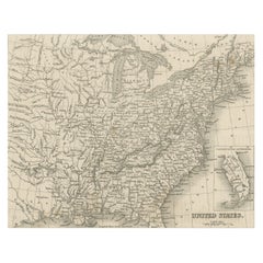
Antique Map of the United States with inset map of the region of Mexico City
About the Item
Antique map titled 'Verein-Staaten von Nord-America, Mexico, Yucatan u.a.'. Very detailed map of the United States of America showing the Caribbean. With an inset map of the surrounding area of Mexico city.
This map originates from Stielers Handatlas, published circa 1859. Stielers Handatlas (after Adolf Stieler, 1775–1836), formally titled Hand-Atlas über alle Theile der Erde und über das Weltgebäude (Handy atlas of all parts of the world and of the universe), was the leading German world atlas of the last three decades of the 19th and the first half of the 20th century. Published by Justus Perthes of Gotha (established 1785 and still existing there) it went through ten editions from 1816 to 1945. As with many 19th century publications, an edition was issued in parts; for example, the eighth edition was issued in 32 monthly parts.
- Dimensions:Height: 14.69 in (37.3 cm)Width: 17.92 in (45.5 cm)Depth: 0.02 in (0.5 mm)
- Materials and Techniques:
- Period:
- Date of Manufacture:c.1859
- Condition:Wear consistent with age and use. General age-related toning, minor wear and foxing. Blank verso. Please study images carefully.
- Seller Location:Langweer, NL
- Reference Number:
About the Seller
5.0
Platinum Seller
These expertly vetted sellers are 1stDibs' most experienced sellers and are rated highest by our customers.
Established in 2009
1stDibs seller since 2017
1,929 sales on 1stDibs
Typical response time: <1 hour
- ShippingRetrieving quote...Ships From: Langweer, Netherlands
- Return PolicyA return for this item may be initiated within 14 days of delivery.
More From This SellerView All
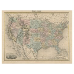
- Antique Map of the Eastern United States with Inset Map of TexasLocated in Langweer, NLAntique map titled 'Verein-Staaten von Nord-America mit Ausnahme Florida's und der Westlichen Territorien'. This map extends as far west as Louisiana and only includes the northern p...Category
Antique Mid-19th Century Maps
MaterialsPaper
- Steel Engraved Map of the United States with Inset Map of FloridaLocated in Langweer, NLAntique map titled 'United States'. Steel engraved map of the United States. With small inset map of the continuation of Florida. Source unknown, to be determined. Published circa 1843.Category
Antique Mid-19th Century Maps
MaterialsPaper
- Antique Map of the United States with Vignette of WashingtonLocated in Langweer, NLAntique map titled 'États-Unis'. A very attractive and detailed late 19th century map of the United States, with a fine decorative vignette of Washington. The extensive railway netwo...Category
Antique Late 19th Century Maps
MaterialsPaper
- Small Map of the United StatesLocated in Langweer, NLAntique map titled 'Amérique septe. Physique'. Small map of the United States. lithographed by C. Callewaert brothers in Brussels circa 1870.Category
Antique Mid-19th Century Maps
MaterialsPaper
- Antique Map of the United States by Balbi '1847'Located in Langweer, NLAntique map titled 'Etats-Unis'. Original antique map of the United States. This map originates from 'Abrégé de Géographie (..)' by Ad...Category
Antique Mid-19th Century Maps
MaterialsPaper
- Antique Map of the United States by Titus '1871'Located in Langweer, NLAntique map titled 'The United States of America'. Original antique map of the United States. This map originates from 'Atlas of Prebl...Category
Antique Late 19th Century Maps
MaterialsPaper


You May Also Like
- Original Antique Map of United States, Grattan and Gilbert, 1843Located in St Annes, LancashireGreat map of United States Drawn and engraved by Archer Published by Grattan and Gilbert. 1843 Original colour Unframed.Category
Antique 1840s English Maps
MaterialsPaper
- 1847 Ornamental Map of the United States & Mexico by H. PhelpsLocated in Colorado Springs, COOffered is an original 1847 ornamental map of the U.S. entitled "Ornamental Map of the United States & Mexico" by Humphrey Phelps. The map was issued as an act of Congress by Phelps on Fulton Street, New York. The broadside is elaborately hand-colored. This is a very detailed and graphic propaganda map of the United States expressing U.S. dominance of the North American continent. The hand-colored map proclaims the Manifest Destiny, with the recent acquisition of Upper California and Texas at the conclusion of the Mexican-American War. The newly acquired land is boldly colored, standing in stark contrast to the rest of the U.S. The map details a potential route for a railroad running from New York City, to Buffalo, to Chicago, then west along the Oregon Trail to Oregon City. This route anticipates the construction of the transcontinental railroad by nearly 20 years. The map includes elaborately detailed renderings of George Washington, Hernan Cortez, and Montezuma at top to represent European expansion to the Americas. At bottom are four inset designs with text showing the following: a chronological history of the U.S. beginning from settlement to the U.S. victory in the Mexican-American war; an illustration of General Zachary Taylor with details on the Oregon Territory; an illustration of the Aztec Temple of the Sun in Tenochtitlan and a chronology of the Conquest of the Aztec Empire under Cortez; a portrait of General Antonio Lopez de Santa Anna...Category
Antique 1840s American Maps
MaterialsPaper
- N.E. View of the United States Capitol, Washington, DC Antique Proof Print 1858Located in Colorado Springs, COThis engraved print shows a view of the United States Capitol Building, in Washington, D.C. The print depicts the neoclassical building from the northeast orientation, with a bustling street scene in front. The steel engraving is a proof printing, drawn and engraved by Henry Sartain and published in 1858. Plans began in May 1854 to build a new cast-iron dome for the United States Capitol. The then-architect of the Capitol Thomas Walter and his team were sold on the aesthetics of a new dome, as well as the utility of a fire-proof one. A year later, on March 3, 1855, President Franklin Pierce...Category
Antique 1850s American Prints
MaterialsPaper
- 1830 Mexico and United States Framed MapLocated in Stamford, CTMap of North America published circa 1830. Map shows United States into Canada. Mexico extending into the upper California territory. Texas appears in name but prior to the period of...Category
Antique 1830s American American Classical Maps
MaterialsGlass, Wood, Paper
- Original Antique Map of The United States of America, circa 1890Located in St Annes, LancashireGreat map of the USA By The Stanford's Geographical Establishment Original colour Unframed.Category
Antique 1890s English Victorian Maps
MaterialsPaper
- Large Original Antique Map of the United States of America. 1891By Rand McNally & Co.Located in St Annes, LancashireFabulous map of The United States Original color By Rand, McNally & Co. Dated 1891 Unframed Free shipping.Category
Antique 1890s American Maps
MaterialsPaper


Recently Viewed
View AllMore Ways To Browse
19th Century Mexican Furniture
Mexican C
Yucatan Mexican
19th Caribbean
Caribbean Antique Furniture
Caribbean Antiques
Antique Mexican Maps
Mexican Antique Map
Antique Caribbean Maps
Antique Caribbean Map
Antique Map Caribbean
Antique Maps Caribbean
Caribbean Antique Maps
Caribbean Map Antique
Antique Map Of Caribbean
Antique Map Of The Caribbean
Antique Maps Of The Caribbean
Caribbean Map