Items Similar to Antique Distance Table Between the Main Cities of Europe by Keizer & De Lat 1788

Want more images or videos?
Request additional images or videos from the seller
1 of 5
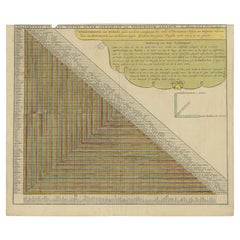
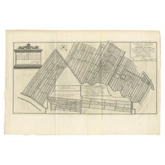
Antique Distance Table Between the Main Cities of Europe by Keizer & De Lat 1788
$207.94
$259.9220% Off
£155.86
£194.8320% Off
€176
€22020% Off
CA$285.67
CA$357.0920% Off
A$318.92
A$398.6520% Off
CHF 167.11
CHF 208.8920% Off
MX$3,903.91
MX$4,879.8920% Off
NOK 2,122.30
NOK 2,652.8820% Off
SEK 2,001.06
SEK 2,501.3320% Off
DKK 1,339.78
DKK 1,674.7220% Off
Shipping
Retrieving quote...The 1stDibs Promise:
Authenticity Guarantee,
Money-Back Guarantee,
24-Hour Cancellation
About the Item
Antique print titled 'Nieuwe Steede-Wyser (..)'. Original antique distance table between the main cities of Europe. This print originates from 'Nieuwe Natuur- Geschied- en Handelkundige Zak- en Reisatlas' by Gerrit Brender à Brandis.
Artists and Engravers: Published by J. Keizer and I. de Lat, 1788.
Condition: General age-related toning. Original folding lines. Original/contemporary hand coloring, blank verso. Minor wear, please study image carefully.
Date: 1788
Overall size: 26.5 x 20.5 cm.
Image size: 21.5 x 18.5 cm.
We also offer thousands of antique prints covering fields of interest as diverse as architecture, natural history, religion, ethnology and many more. Antique prints have long been appreciated for both their aesthetic and investment value. They were the product of engraved, etched or lithographed plates. These plates were handmade out of wood or metal, which required an incredible level of skill, patience and craftsmanship. Whether you have a house with Victorian furniture or more contemporary decor an old engraving can enhance your living space.
- Dimensions:Height: 8.08 in (20.5 cm)Width: 10.44 in (26.5 cm)Depth: 0 in (0.01 mm)
- Materials and Techniques:
- Period:
- Date of Manufacture:1788
- Condition:
- Seller Location:Langweer, NL
- Reference Number:Seller: BG-12854-461stDibs: LU3054325943252
About the Seller
5.0
Recognized Seller
These prestigious sellers are industry leaders and represent the highest echelon for item quality and design.
Platinum Seller
Premium sellers with a 4.7+ rating and 24-hour response times
Established in 2009
1stDibs seller since 2017
2,511 sales on 1stDibs
Typical response time: <1 hour
- ShippingRetrieving quote...Shipping from: Langweer, Netherlands
- Return Policy
Authenticity Guarantee
In the unlikely event there’s an issue with an item’s authenticity, contact us within 1 year for a full refund. DetailsMoney-Back Guarantee
If your item is not as described, is damaged in transit, or does not arrive, contact us within 7 days for a full refund. Details24-Hour Cancellation
You have a 24-hour grace period in which to reconsider your purchase, with no questions asked.Vetted Professional Sellers
Our world-class sellers must adhere to strict standards for service and quality, maintaining the integrity of our listings.Price-Match Guarantee
If you find that a seller listed the same item for a lower price elsewhere, we’ll match it.Trusted Global Delivery
Our best-in-class carrier network provides specialized shipping options worldwide, including custom delivery.More From This Seller
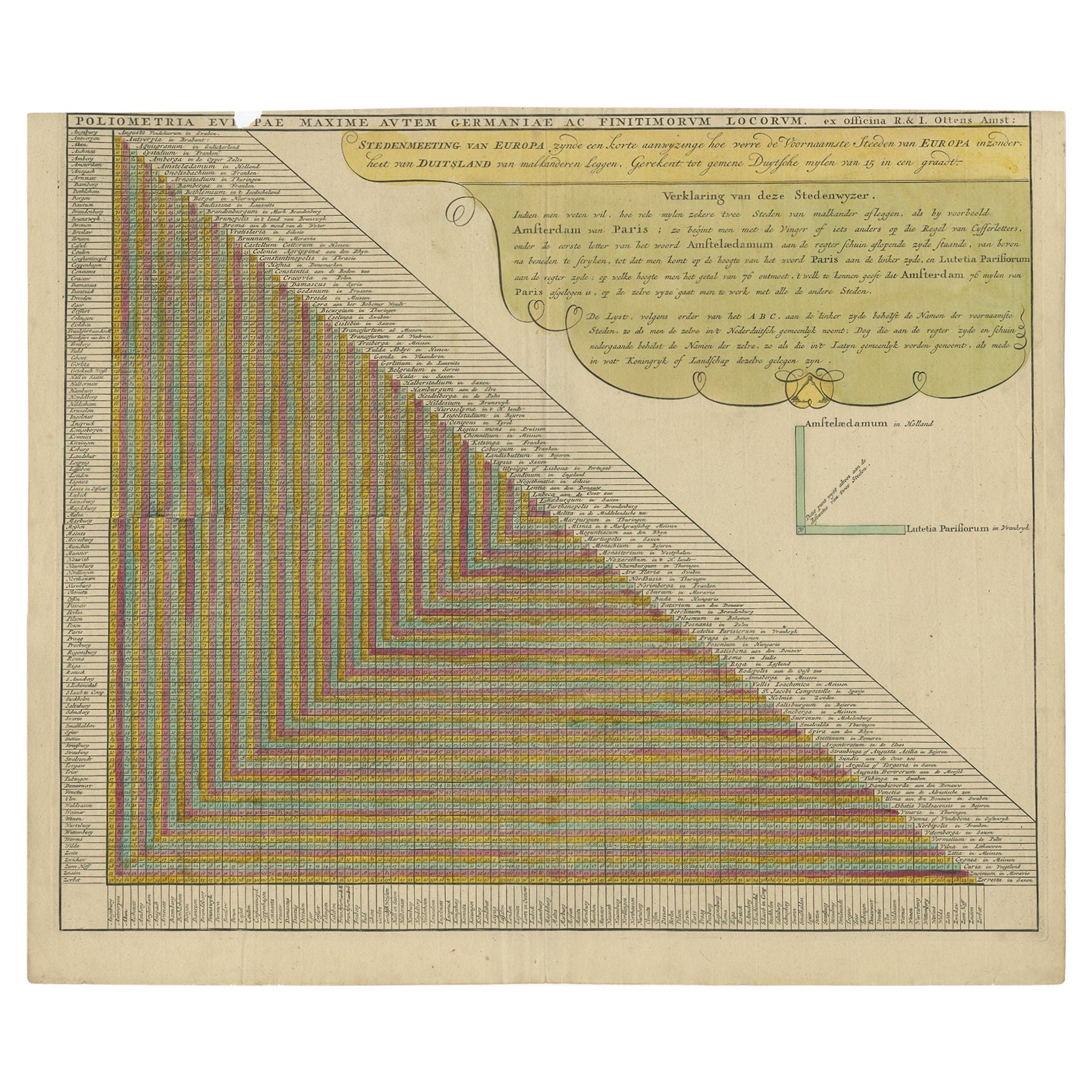
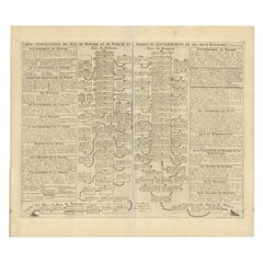
View AllUnusual Chart Showing Traveling Distances Between European Cities, C.1726
Located in Langweer, NL
Antique print Europe titled 'Poliometria Europae Maxime Autem Germaniae ac Finitimorum Locorum'.
This unusual chart depicts the traveling distances between various European citie...
Category
Antique 1720s Prints
Materials
Paper
$633 Sale Price
20% Off
Antique Genealogy Chart of Weteravie, Swabia, Westphalia & Franconia, 1732
Located in Langweer, NL
Antique print titled 'Carte de la Seconde Noblesse (..)'. Chart of the noble counts of the second branch of Weteravie, Swabia, Westphalia and Franconia. This print orginates from 'At...
Category
Antique 18th Century Prints
Materials
Paper

$170 Sale Price
20% Off
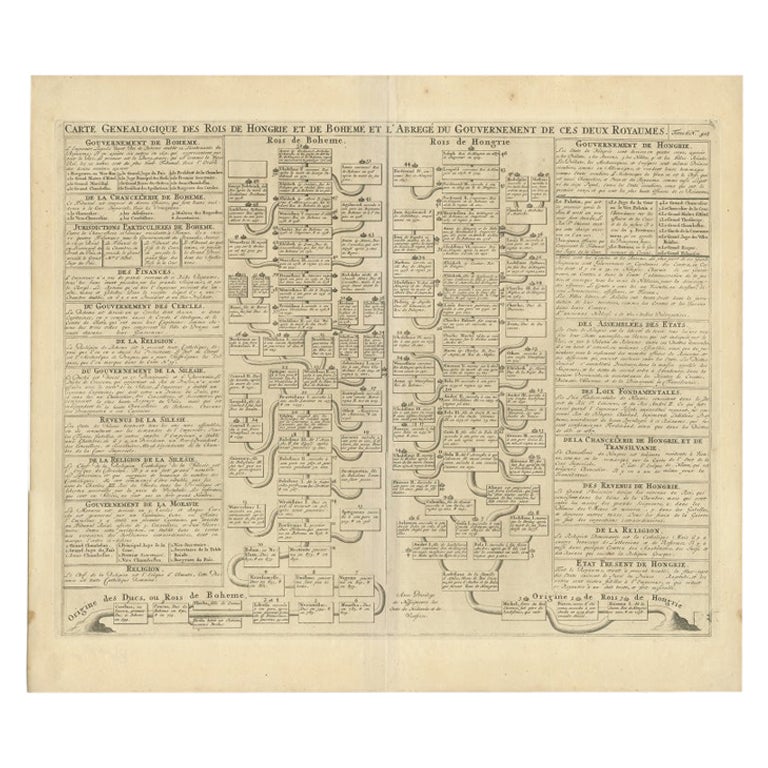
Antique Genealogy Chart of the Kings of Hungary and Bohemia by Chatelain, 1732
Located in Langweer, NL
Antique print titled 'Carte Genealogique des Rois de Hongrie (..)'. Genealogical chart of the kings of Hungary and Bohemia. This print orginates from 'Atlas H...
Category
Antique 18th Century Prints
Materials
Paper
$226 Sale Price
20% Off
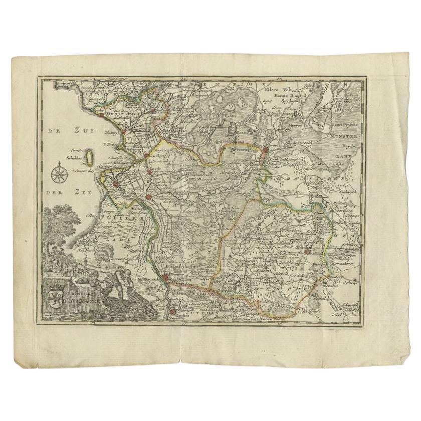
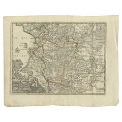
Antique Map of the Province of Overijssel by Keizer & De Lat, 1788
Located in Langweer, NL
Antique map titled 'Seigneurie d'Over-Ysel'. Uncommon antique map of the province of Overijssel, the Netherlands. This map originates from 'Nieuwe Natuur- Geschied- en Handelkundige ...
Category
Antique 18th Century Maps
Materials
Paper
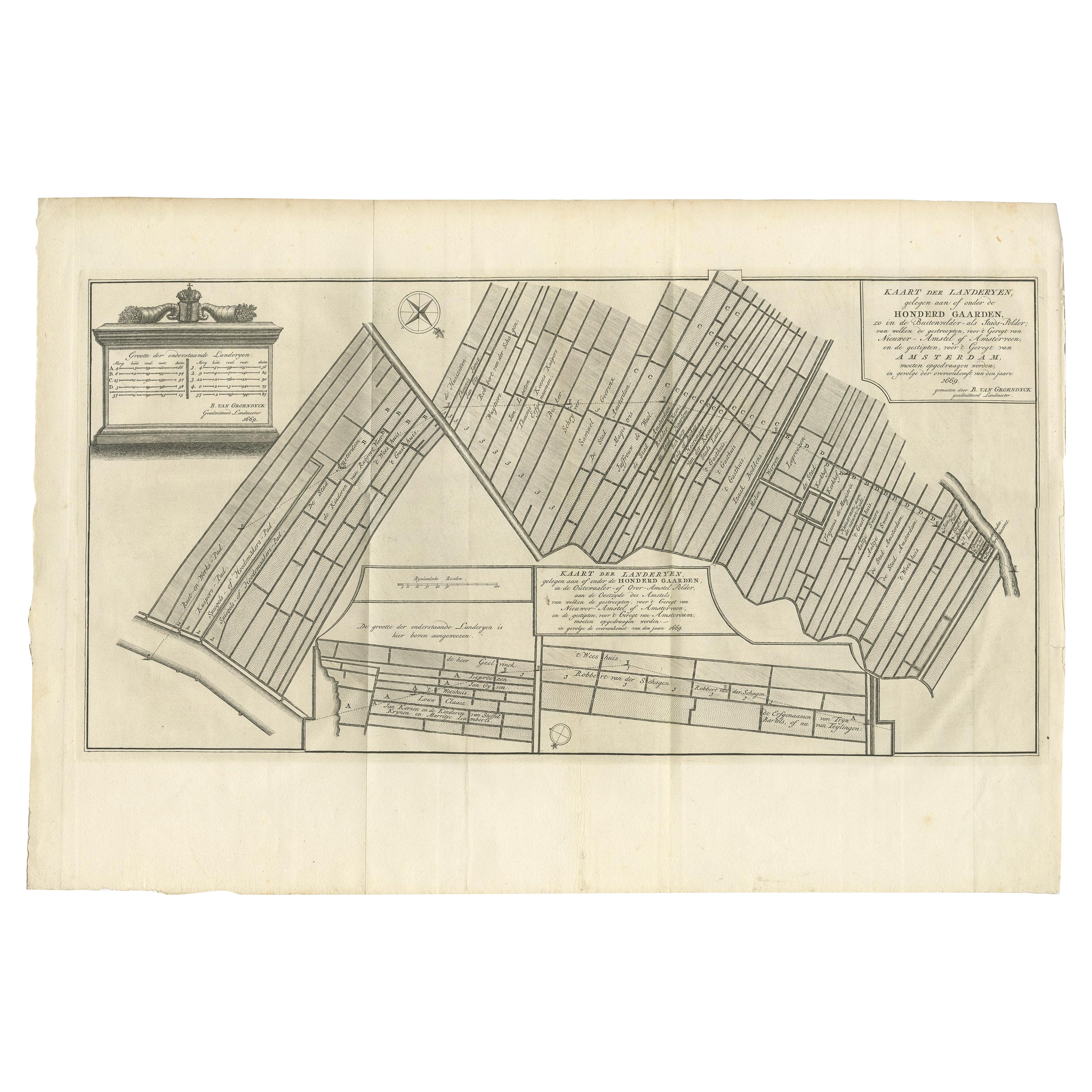
Antique Map Showing Estates of 1669 in Amsterdam, Published in c.1767
Located in Langweer, NL
Antique map titled 'Kaart der landeryen, gelegen aan of onder de honderd gaarden, zo in de Buitenvelder- als Stads-polder; van welken de gestreepten, voor 't geregt van Nieuwer-Amste...
Category
Antique 18th Century Maps
Materials
Paper
$236 Sale Price
20% Off
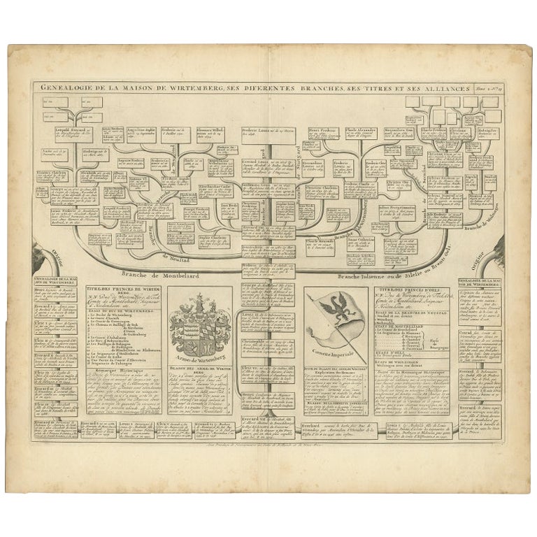
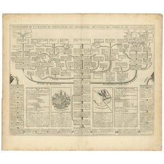
Antique Genealogy Chart of the House of Wurttemberg in Germany, 1732
Located in Langweer, NL
Antique print titled 'Genealogie de la Maison de Wirtemberg (..)'. Genealogy of the House Wurttemberg. This print orginates from 'Atlas Historique'.
The House of Württemberg is a...
Category
Antique 18th Century Prints
Materials
Paper
$245 Sale Price
20% Off
You May Also Like
Old Map Depicting the Entire Earth's Surface Divided into Six Parts France 1850
Located in Milan, IT
Map depicting the entire earth's surface divided into six parts which depicts the position of peoples on Earth based on the assumption that it is impossible for each people to have t...
Category
Antique Mid-19th Century French Maps
Materials
Glass, Wood, Paper

1839 Map of Karte Des "Russischen Reiches in Europa Und Asien" Ric.R0013
Located in Norton, MA
1839 map of Karte Des
"Russischen Reiches in Europa and Asien"
Ric.r013
Map of the European and Asian parts of Russian Empire. Karte der Russischen Reiches in Europa und Asien...
Category
Antique 19th Century Unknown Maps
Materials
Paper

Carta ad uso del viaggio di Anacarsi il giovine del cartografo D'Anville 1790
Located in Milan, IT
Carta che riproduce la mappa dell’Accademia e i suoi contorni nei pressi di Atene ad uso del viaggio di Anacarsi il giovine, del Signor Barbie di Bocage; la carta, realizzata dal cartografo D'Anville, faceva parte dell'opera: Viaggio del giovane Anacarsi in Grecia di Jean Jacques Barthélemy (1716-1795), rinomato filologo e classicista, pubblicata in lingua italiana...
Category
Antique Late 18th Century Prints
Materials
Paper

1752 Vaugoundy Map of Flanders : Belgium, France, and the Netherlands, Ric.a002
Located in Norton, MA
Large Vaugoundy Map of Flanders:
Belgium, France, and the Netherlands
Colored -1752
Ric.a002
Description: This is a 1752 Didier Robert de Vaugondy map of Flanders. The map de...
Category
Antique 17th Century Unknown Maps
Materials
Paper

1850 Old French Map Depicting the Entire Earth's Surface Divided into Two Parts
Located in Milan, IT
Map depicting the entire earth's surface divided into two parts corresponding to the two hemispheres and showing the Arctic to Antarctic polar circle, the tropics of Cancer and Capri...
Category
Antique Mid-19th Century French Maps
Materials
Glass, Wood, Paper
1850 Old French Map Depicting the Entire Earth's Surface Divided into Two Parts
Located in Milan, IT
Geographical map depicting the entire earth’s surface divided into two parts that correspond to the two hemispheres or globes, the map deals with the latitudes and longitudes, the me...
Category
Antique Mid-19th Century French Maps
Materials
Glass, Wood, Paper

More Ways To Browse
Vintage Green Glass Footed Bowl
Vintage Skates
Vintage Stone Crusher
Vintage Stone Shoes
Windsor Dining Table
16th Century Bed
800 Silver Tea Set
Abercrombie Leather
Abhaya Mudra
African Container
Antique 2 Over 3 Chest Of Drawers
Antique Barrow
Antique Chinese Porcelain Statues
Antique Desk Globe
Antique Dirk
Antique Figurehead
Antique Figureheads
Antique Fireplace Mantel Clocks