Items Similar to Antique Map of Alexandria Egypt – Plan of Vetus & Nova, Inset of Patriarch Seat

Want more images or videos?
Request additional images or videos from the seller
1 of 10
Antique Map of Alexandria Egypt – Plan of Vetus & Nova, Inset of Patriarch Seat
$267.99
£202.12
€230
CA$370.53
A$415.05
CHF 218
MX$5,046.88
NOK 2,760.59
SEK 2,620.54
DKK 1,750.91
About the Item
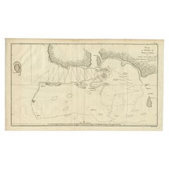
Antique Map of Alexandria Egypt – Plan of Vetus & Nova with Inset of Patriarch Seat
This finely engraved 18th-century map presents an early and detailed plan of Alexandria, Egypt, showcasing the ancient city in its dual structure: Alexandria Vetus (Old Alexandria) and Alexandria Nova (New Alexandria). The map bears the Dutch title "Grondteekening van Alexandrië," which translates as "Ground Plan of Alexandria," and includes an inset in the top right corner titled "De Patriarchaale Stoel," depicting the Patriarchal Seat, a significant ecclesiastical structure in the Coptic tradition.
The plan offers an intricate view of the city's fortifications, harbors, canals, streets, and urban layout. Lettered and numbered references indicate buildings, topographic features, water bodies, and other landmarks, which were likely explained in an accompanying key or text from the original publication. The canal labeled "Kenoptische Kanaal" is prominently shown connecting Alexandria with the Nile Delta region, emphasizing the city’s strategic importance in trade and navigation.
This print is from the rare Dutch edition of Cornelis de Bruijn’s travel accounts, likely *Reizen door de vermaardste Deelen van Klein Asia* or *Reizen over Moskovie, door Persie en Indie*, published in The Hague in the early 18th century (1710s–1730s). De Bruijn (1652–1726/27) was a Dutch artist and traveler known for his detailed visual accounts of the Middle East, Egypt, Persia, and beyond.
The engraving is rendered with fine linear detail, typical of the copperplate technique, and serves both scientific and artistic purposes. The map captures the early Enlightenment fascination with antiquity, topography, and empirical geography.
Condition:
Very good condition overall. Some light fold marks as issued, minor edge toning and small tears in the margins (not affecting the printed area). Paper is strong with good plate impression.
Framing tips:
This print would present beautifully in a classic dark wood frame with a soft off-white or parchment-colored mat. For a more scholarly or antique appearance, consider using a distressed gold frame or archival walnut finish, which complements the historical tone and the engraved detailing.
Technique: Copperplate engraving
Maker: After Cornelis de Bruijn, The Netherlands, early 18th century
- Dimensions:Height: 10.63 in (27 cm)Width: 18.82 in (47.8 cm)Depth: 0.01 in (0.2 mm)
- Materials and Techniques:Paper,Engraved
- Place of Origin:
- Period:
- Date of Manufacture:1776
- Condition:Very good condition overall. Some light fold marks as issued, minor edge toning and small tears in the margins (not affecting the printed area). Paper is strong with good plate impression.
- Seller Location:Langweer, NL
- Reference Number:Seller: BG-14102-661stDibs: LU3054346058062
About the Seller
5.0
Recognized Seller
These prestigious sellers are industry leaders and represent the highest echelon for item quality and design.
Platinum Seller
Premium sellers with a 4.7+ rating and 24-hour response times
Established in 2009
1stDibs seller since 2017
2,517 sales on 1stDibs
Typical response time: <1 hour
- ShippingRetrieving quote...Shipping from: Langweer, Netherlands
- Return Policy
Authenticity Guarantee
In the unlikely event there’s an issue with an item’s authenticity, contact us within 1 year for a full refund. DetailsMoney-Back Guarantee
If your item is not as described, is damaged in transit, or does not arrive, contact us within 7 days for a full refund. Details24-Hour Cancellation
You have a 24-hour grace period in which to reconsider your purchase, with no questions asked.Vetted Professional Sellers
Our world-class sellers must adhere to strict standards for service and quality, maintaining the integrity of our listings.Price-Match Guarantee
If you find that a seller listed the same item for a lower price elsewhere, we’ll match it.Trusted Global Delivery
Our best-in-class carrier network provides specialized shipping options worldwide, including custom delivery.More From This Seller
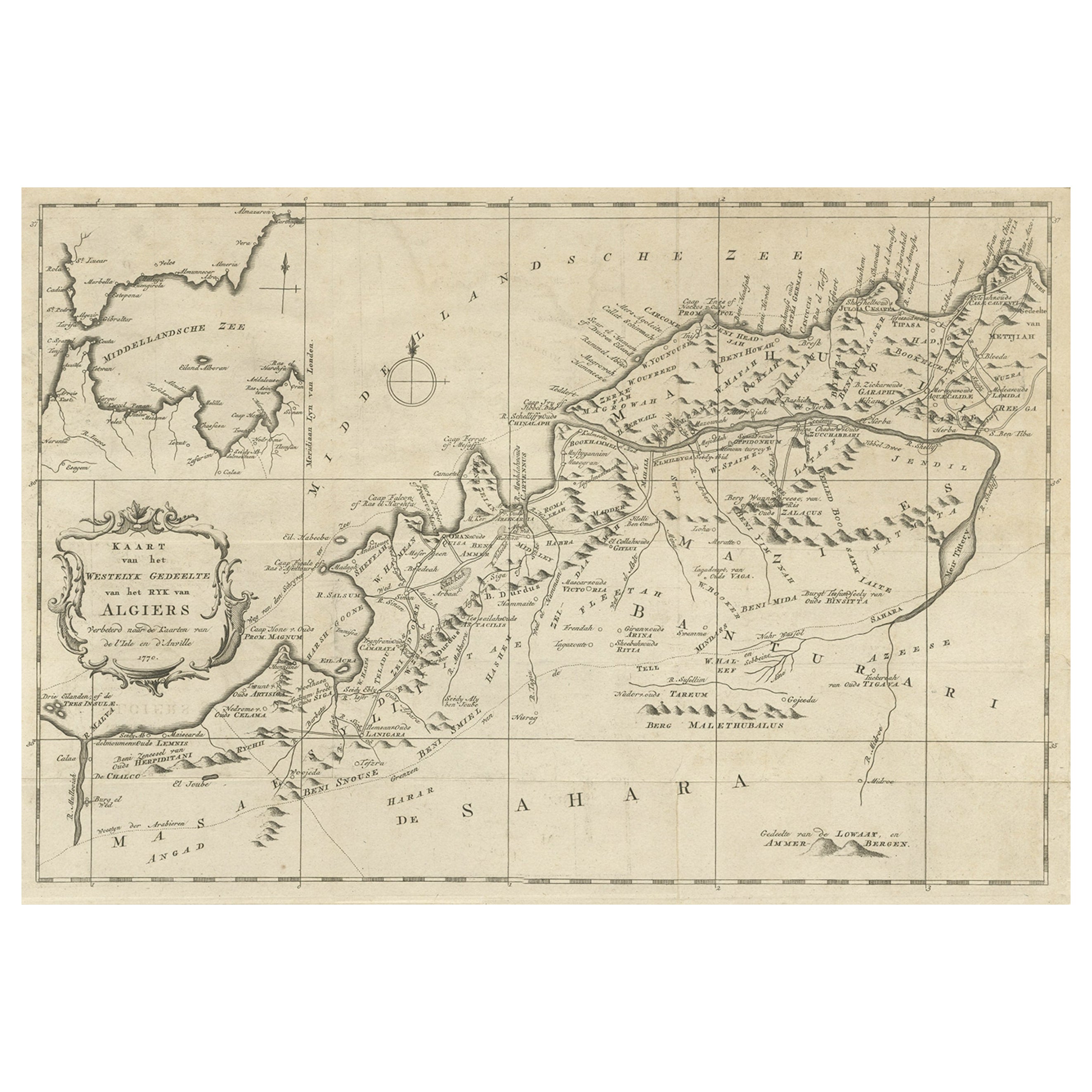
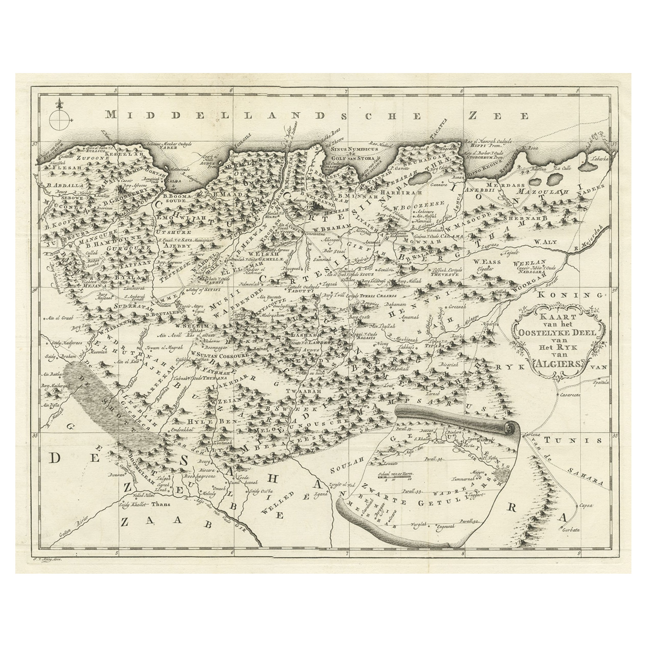
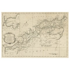
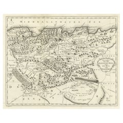
View AllOld Map of the Western Region of the Kingdom of Algiers, Algeria, 1773
Located in Langweer, NL
Antique map titled 'Kaart van het Westelyk Gedeelte van het Ryk van Algiers'.
Old map of the western region of the Kingdom of Algiers, Algeria. Originates from the first Dutch ed...
Category
Antique 1770s Maps
Materials
Paper
$354 Sale Price
20% Off
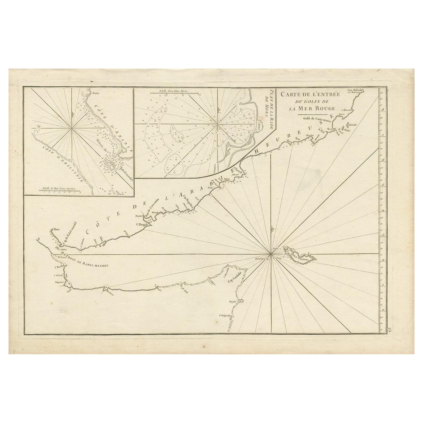
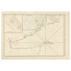
Original Antique Engraved Map of Part of the Red Sea, Arabia, 1775
Located in Langweer, NL
Antique map titled 'Carte de l'Entrée du Golfe de la Mer Rouge'. Uncommon sea chart of the entrance to the Red Seas as far as Mocha, with rhumb lines and soundings. Two insets of the...
Category
Antique Late 18th Century Maps
Materials
Paper
$442 Sale Price
20% Off
Antique Map of Northern Africa by Perthes, 1848
Located in Langweer, NL
Antique map titled 'Africa Propria (..)'. Old map of North Africa and the region of Babylon originating from 'Orbis Terrarum Antiquus in usum Scholarum'. Artists and Engravers: Publi...
Category
Antique 19th Century Maps
Materials
Paper

$92 Sale Price
20% Off
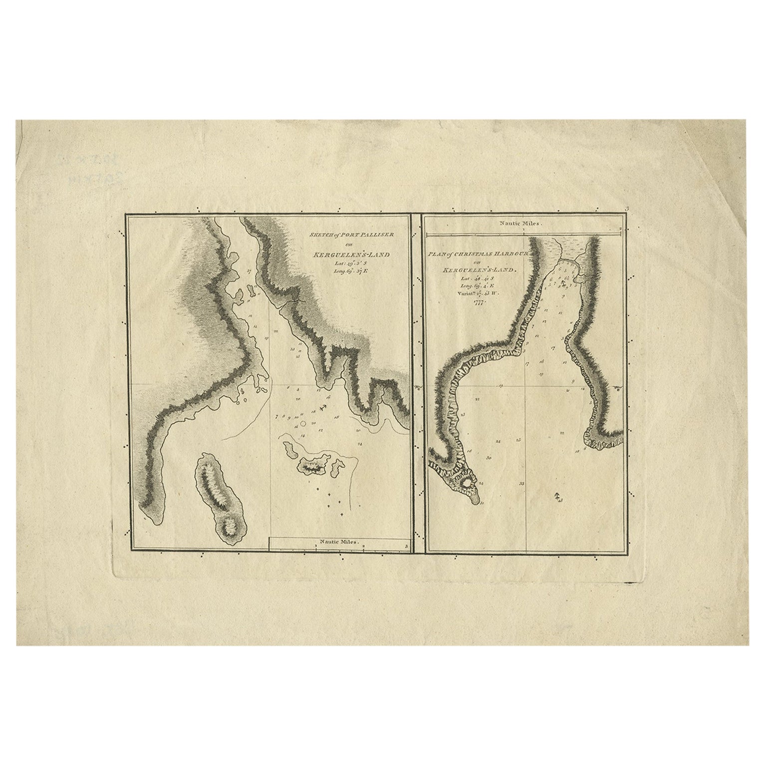
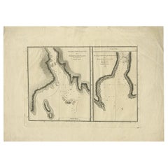
Antique Map of Port Pallisers & Kersmis by Cook, 1784
Located in Langweer, NL
Antique map Kerguelen titled 'Sketch of Port Palliser on Kerguelen's Land (..)'. Antique map of Port Pallisers & Kersmis, Kerguelen or Desolation Islands. Originates from an edition ...
Category
Antique 18th Century Maps
Materials
Paper
$204 Sale Price
20% Off
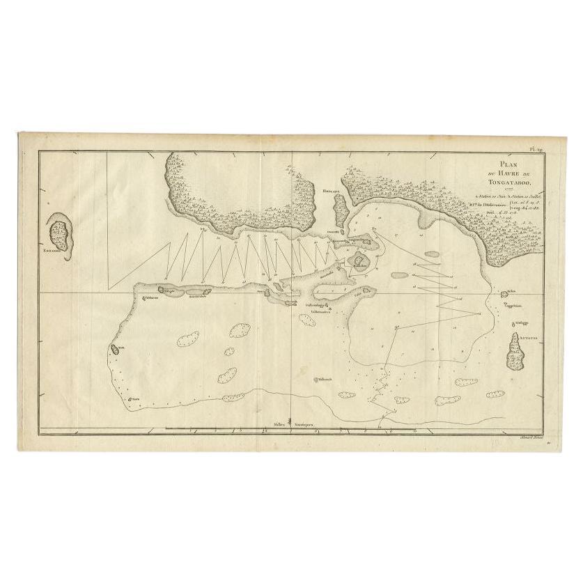
Antique Map of the Northern Coast of Tongatapu by Benard, c.1785
Located in Langweer, NL
Antique map titled 'Plan du Havre de Tongataboo'. Original antique map of Tongapatu's northern coast. This map originates from 'A New, Authentic and Complete Collection of Voyages Ro...
Category
Antique 18th Century Maps
Materials
Paper
$116 Sale Price
20% Off
Old Map of the Eastern Region of the Kingdom of Algiers, Algeria, 1773
Located in Langweer, NL
Antique map titled 'Kaart van het Oostelyke Deel van het Ryk van Algiers'.
Old map of the eastern region of the Kingdom of Algiers, Algeria. Originates from the first Dutch edito...
Category
Antique 1770s Maps
Materials
Paper
$428 Sale Price
20% Off
You May Also Like
1597 German Map of Alexandria by Georg Braun and Frans Hogenberg
By Georg Braun and Frans Hogenberg
Located in Chapel Hill, NC
1597 Map of Alexandria by Georg Braun and Frans Hogenberg, Germany. From "Civitas Orbis Terrarum", part 2, published in Cologne by Bertram Buchholz. Printed in 2 parts. Title: "Alexa...
Category
Antique 16th Century German Renaissance Maps
Materials
Paper

Original Antique Map of Ancient Greece, Achaia, Corinth, 1786
Located in St Annes, Lancashire
Great map of Ancient Greece. Showing the region of Thessaly, including Mount Olympus
Drawn by J.D. Barbie Du Bocage
Copper plate engraving by P.F Tardieu
Original hand color...
Category
Antique 1780s French Other Maps
Materials
Paper

1646 Jansson Map Entitled "Procinvia Connactiae, " Ric.a006
Located in Norton, MA
1646 Jansson map entitled
"Procinvia connactiae,"
Ric.a006
Description: The PROVINCE of CONNAVGT 490 x 380From vol 4 of Jansson's Atlas Novus 1646, published in Amsterdam with...
Category
Antique 17th Century Unknown Maps
Materials
Paper

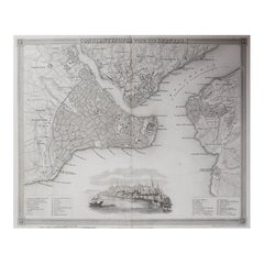
Original Antique Map or City Plan of Istanbul, Turkey. Circa 1835
Located in St Annes, Lancashire
Nice map of Istanbul
Drawn and engraved by J.Dower
Published by Orr & Smith. C.1835
Unframed.
Free shipping
Category
Antique 1830s English Maps
Materials
Paper
Antique Lithography Map, West Africa, English, Framed, Cartography, Victorian
Located in Hele, Devon, GB
This is an antique lithography map of Western Africa. An English, framed atlas engraving of cartographic interest by John Rapkin, dating to the early Victorian period and later, circ...
Category
Antique Mid-19th Century British Early Victorian Maps
Materials
Wood

Original Antique Map of the American State of Michigan ( Northern Part ), 1903
Located in St Annes, Lancashire
Antique map of Michigan ( Northern part )
Published By A & C Black. 1903
Original colour
Good condition
Unframed.
Free shipping
Category
Antique Early 1900s English Maps
Materials
Paper
