Items Similar to Edinburgh City Plan, Italy c.1700 – “Edenburgo Metropoli della Scozia”

Want more images or videos?
Request additional images or videos from the seller
1 of 10
Edinburgh City Plan, Italy c.1700 – “Edenburgo Metropoli della Scozia”
$512.68
£386.66
€440
CA$708.83
A$794.01
CHF 417.04
MX$9,654.91
NOK 5,281.12
SEK 5,013.21
DKK 3,349.57
About the Item
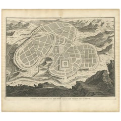
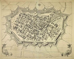
Edinburgh City Plan, Italy c.1700 – “Edenburgo Metropoli della Scozia”
This is a charming hand-colored engraved plan of Edinburgh, titled in Italian Edenburgo, Metropoli della Scozia, meaning “Edinburgh, Metropolis of Scotland.” The print depicts a bird’s-eye view city plan showing the detailed street layout, surrounding hills, and the prominent Edinburgh Castle set upon its rocky outcrop.
The map’s style and Italian title indicate it was published in the late 17th or early 18th century, likely by publishers such as Pietro Bertelli or in reissues by Italian map and city view publishers in Padua or Venice. This type of city plan was popular during the Grand Tour period when Italian engravers produced extensive series of European city views and plans for educated travellers and collectors.
The engraving shows a fortified medieval city layout with bastions and gates, streets neatly arranged within walls, small trees scattered in the background, and surrounding hills giving a sense of natural fortification. The castle is prominently illustrated on the left, atop Castle Rock, emphasizing its importance in Scotland’s history as a royal fortress and military stronghold.
These city plans were often published alongside panoramic views and regional maps, forming part of works such as *Civitates Orbis Terrarum* or Italian geographical atlases. They served not only as references but also as cultural representations of Europe’s major cities, widely collected by scholars and nobles.
Condition Report:
Very good condition overall. Strong and vivid contemporary hand coloring. Some light general age toning and faint marginal foxing, typical for its age. Paper edges with minimal wear. No tears or repairs noted. Wide margins present, ideal for framing.
Framing Tip:
Best displayed with an antique-style gold, dark wood, or ebonised frame and an archival off-white mat with a fine gold or red inner line to complement the Italian aesthetic. Use UV-protective glass to maintain color vibrancy.
- Dimensions:Height: 7.92 in (20.1 cm)Width: 10.99 in (27.9 cm)Depth: 0.01 in (0.2 mm)
- Materials and Techniques:Paper,Engraved
- Place of Origin:
- Period:
- Date of Manufacture:circa 1700
- Condition:Very good condition overall. Strong and vivid contemporary hand coloring. Some light general age toning and faint marginal foxing, typical for its age. Paper edges with minimal wear. No tears or repairs noted. Wide margins present, ideal for framing.
- Seller Location:Langweer, NL
- Reference Number:Seller: BG-13130-41stDibs: LU3054345716242
About the Seller
5.0
Recognized Seller
These prestigious sellers are industry leaders and represent the highest echelon for item quality and design.
Platinum Seller
Premium sellers with a 4.7+ rating and 24-hour response times
Established in 2009
1stDibs seller since 2017
2,517 sales on 1stDibs
Typical response time: <1 hour
- ShippingRetrieving quote...Shipping from: Langweer, Netherlands
- Return Policy
Authenticity Guarantee
In the unlikely event there’s an issue with an item’s authenticity, contact us within 1 year for a full refund. DetailsMoney-Back Guarantee
If your item is not as described, is damaged in transit, or does not arrive, contact us within 7 days for a full refund. Details24-Hour Cancellation
You have a 24-hour grace period in which to reconsider your purchase, with no questions asked.Vetted Professional Sellers
Our world-class sellers must adhere to strict standards for service and quality, maintaining the integrity of our listings.Price-Match Guarantee
If you find that a seller listed the same item for a lower price elsewhere, we’ll match it.Trusted Global Delivery
Our best-in-class carrier network provides specialized shipping options worldwide, including custom delivery.More From This Seller
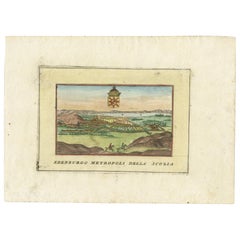
View AllHand-Colored View of Edinburgh, Italy, c.1700 – “Edenburgo Metropoli”
Located in Langweer, NL
Hand-Colored View of Edinburgh, Italy, c.1700 – “Edenburgo Metropoli”
This finely hand-colored engraving shows a panoramic view of Edinburgh, titled in Italian “Edenburgo Metropoli ...
Category
Antique Early 18th Century Italian Prints
Materials
Paper
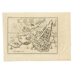
Antique Engraving with a Plan of Rhodes, Greece, 1688
Located in Langweer, NL
Description: Antique map, titled: 'Rhodos.' - Plan of Rhodes, Greece. This map originates from 'Nauwkeurige Beschrijving der eilanden in de in de Archipel der Middellantsche Zee', by...
Category
Antique 1680s Maps
Materials
Paper
$419 Sale Price
20% Off
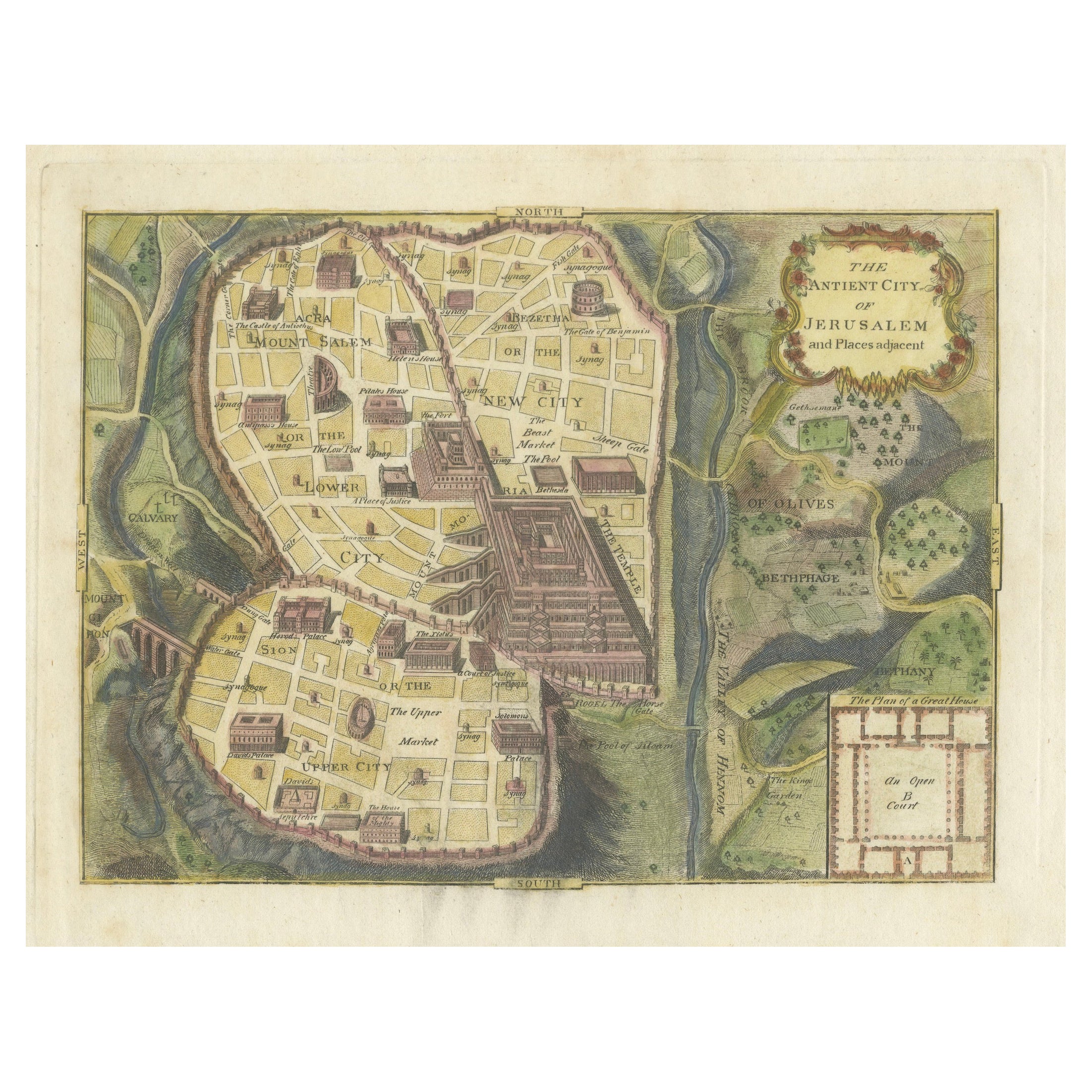
The Antient City of Jerusalem and Places Adjacent, Hand-Colored Map, 1699
Located in Langweer, NL
Title: "1699 Hand-Colored Bird's-Eye Plan of Jerusalem with Ancient and Biblical Landmarks"
This beautifully hand-colored, imaginary bird's-eye plan of Jerusalem, published in 1699,...
Category
Antique 1690s Maps
Materials
Paper
$242 Sale Price
20% Off
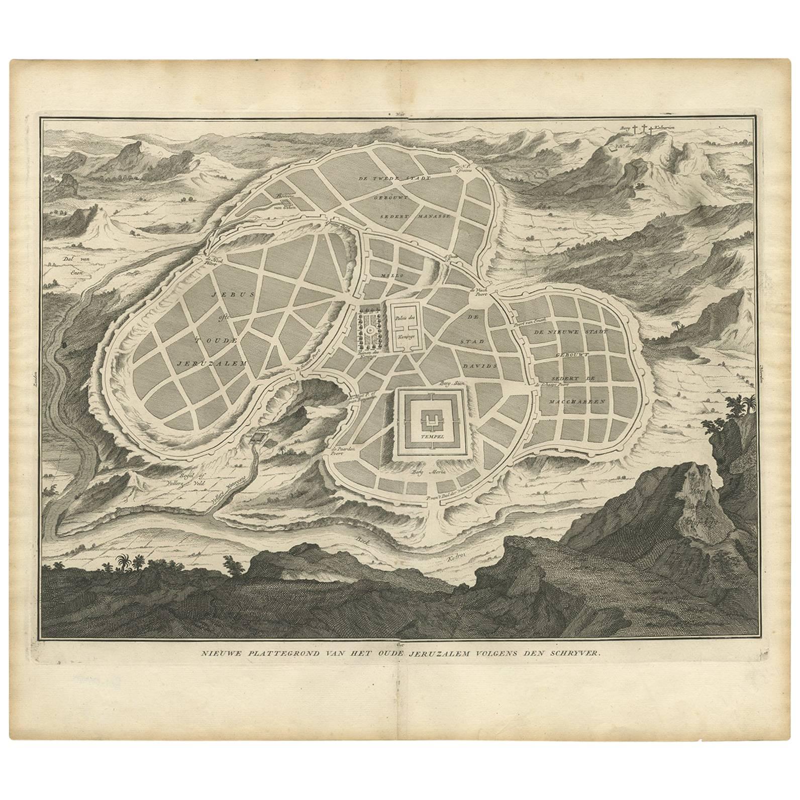
Antique Map of the Ancient City of Jerusalem by A. Calmet, 1725
Located in Langweer, NL
Antique map, titled: 'Nieuwe Plattegrond van het Oude Jeruzalem Volgens den Schryver.' - Bird's-eye view of the ancient city of Jerusalem shows its divisions with prominent depiction...
Category
Antique Early 18th Century Prints
Materials
Paper
$242 Sale Price
20% Off
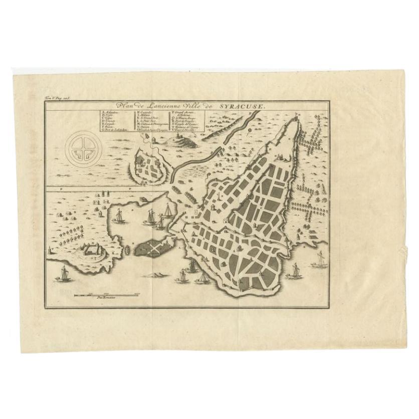
Antique Plan of Ancient Syracuse, cicily, Italy, 1740
Located in Langweer, NL
Antique print titled 'Plan de l'Ancienne Ville de Syracuse'. Plan of ancient Syracuse, Sicily, Italy. Source unknown, to be determined.
Artists and Engravers: Anonymous.
Condit...
Category
Antique 18th Century Maps
Materials
Paper
$270 Sale Price
20% Off
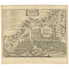
Antique Map of the City of Ambon by Valentijn, 1726
By F. Valentijn
Located in Langweer, NL
Antique map titled 'De Platte Grond van Amboina zoo als het was in den Jaare, 1718'. Antique map depicting the City of Ambon, Indonesia. This print originates from 'Oud en Nieuw Oost...
Category
Antique Early 18th Century Dutch Maps
Materials
Paper
$512 Sale Price
20% Off
You May Also Like
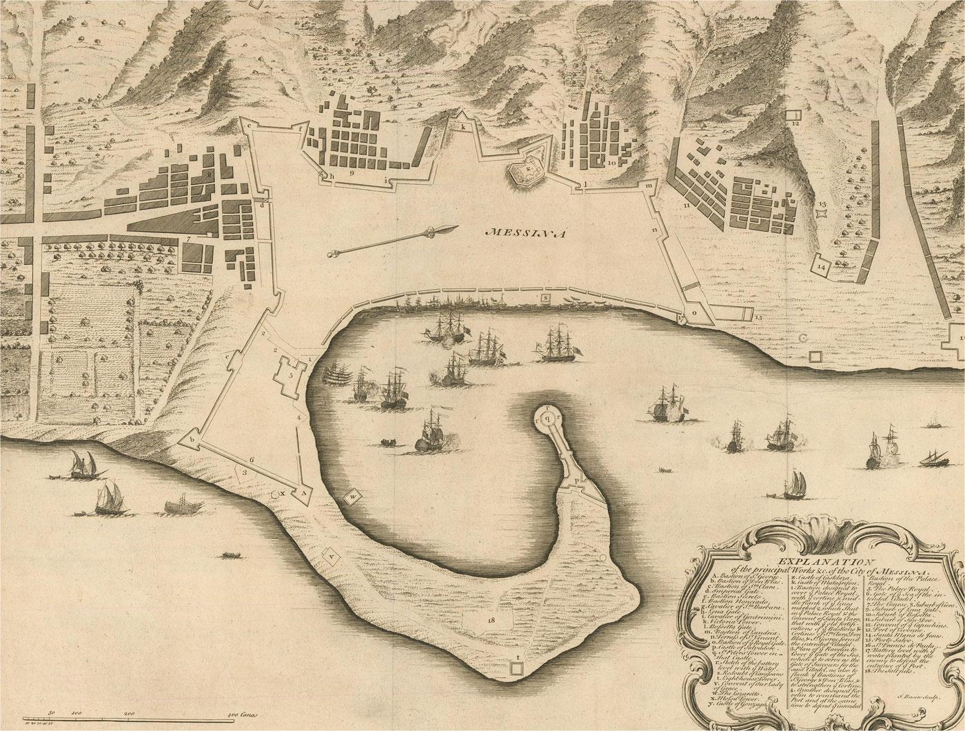
18th Century Map Engraving - Plan of the Works of the City of Messina, Sicily
Located in Corsham, GB
A map of Messina, a harbour city in northeast Sicily. Inscribed with the title in plate to the lower edge, 'Plan of the Works of the City of Messina, one of the strongest and most co...
Category
18th Century More Prints
Materials
Engraving

$285 Sale Price
20% Off
Architectural Roman Map - Etching by Vincenzo Scarpati - 18th Century
Located in Roma, IT
Architectural Roman Map from "Antiquities of Herculaneum" is an etching on paper realized by Vincenzo Scarpati in the 18th Century.
Signed on the plate.
Go...
Category
18th Century Old Masters Figurative Prints
Materials
Etching

Li Governi di Borgogna - Ancient Map - 1777
Located in Roma, IT
Li Governi di Borgogna is an original black and white etching on paper, printed by Antonio Zatta in Venice, 1777.
Original Title: Li Governi di Borgogna della Franca Contea e del Ly...
Category
1770s Modern Landscape Prints
Materials
Etching

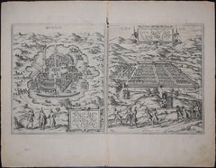
Mexico City & Cusco Antique Map, Civitates Orbis Terrarum by Braun & Hogenberg
By Franz Hogenberg
Located in Roma, IT
Etching black and white from Civitates Orbis Terrarum. View of the Old Mexico City, built over the ruins of the Aztec city of Tenochtitlán from 1520, and Cusco, ancient capital of th...
Category
16th Century Landscape Prints
Materials
Etching
View of Seravalle, Italy: A 16th Century Hand-colored Map by Braun & Hogenberg
By Franz Hogenberg
Located in Alamo, CA
This is an original 16th century copperplate originally hand-colored engraved map of View of Seravalle, Italy entitled "Seravallum Celeberrimum Marchiae Tarvisiniae in Agro Foro Juliensi Opp. - Seravalli, quam vides, Spectator, iconem, operi huic nostro suis sumptib. . . ." by Georg Braun & Franz Hogenberg, from their famous city atlas "Civitates Orbis Terrarum", published in Augsberg, Germany in 1575.
The map depicts a view of Seravalle, now Vittorio Veneto, in San Marino, Italy, north of Venice, in a topographically accurate bird's-eye view from the south. A water-filled moat is seen to the south of the city walls and farmland to the east. Two men are depicted standing on a hill in the lower right in conversation next to grain sacks and a grazing horse, while a younger man behind them to the right herds a mule carrying presumably pigs. A very colorful and ornate title cartouche is in the upper center and coat-of-arms are in the right and left upper corners. Serravalle lies in an idyllic setting in the foothills and surrounded by orchards. St Mary's Cathedral with its tall bell tower is prominent in the center of the town. The marketplace and town hall with a bell tower in the square are depicted. Houses and shops are around the main square. Serravalle's importance as an agricultural centre is emphasized by the figures in the foreground. In 1337 Serravalle was conquered by the Republic of Venice. In 1866 the town was united with neighbouring Ceneda to form the town of Vittorio Veneto.
The following is an English translation of an excerpt from the French description of the city on the back of the map: "Serravalle, a market town renowned for cloth, wine and grain, is in such a beautiful situation that the number of its inhabitants, attracted by the loveliness of the place, has grown so much at times that the wall encircling it has had to be enlarged for the third time. The city with the surrounding town once belonged to the Church in Ceneda as an imperial fief. It subsequently became the seat of the Da Camino family (a princely house that at that time was one of the five most noble in all Italy). Now the city is under the sway of the Venetians but is prudently governed by them. For they send only one city councillor with instructions to ensure that justice prevails and to collect duties. In all else, power lies in the hands of the noble families."
This is a translation of the Latin in the title cartouche on the front: "The picture of the town of Serravalle, which you see, viewer, has been contributed to our work entirely at his own expense by Minutius, son of Hieronymus Minutius, a noble gentleman and one renowned for the far-reaching competence of his jurisdiction. We saw him sojourning in Cologne, where he was on business for Gregory XIII; while our good wishes accompany him, we should also like to accompany him on his way with this remembrance, even though it might be against his will, so that even those who have not seen him may learn of his excellence. However, those who do not yet know him will also see his excellence if God the Almighthy does not summon erring souls too soon back to the eternal seat of the Blessed."
References: Van der Krogt 4, 4728, State 1; Taschen, Braun and Hogenberg, p.331; Fauser, #14960
This striking hand-colored city view is printed on laid, chain-linked paper with wide margins. The sheet measures 16" high by 21" wide. There is a central vertical fold as issued and French text on the verso, with Latin on the front. There is some discoloration in the upper and right margins which may represent some watercolor paint from the time of the original hand-coloring of the map. There is a small hole to the right of the upper portion of the vertical fold, which is only visible when held up to light and an area of reinforcement on the verso of the lower vertical fold. The map is otherwise in very good to excellent condition.
Braun and Hogenberg's 'The Civitates Orbis Terrarum' was the second atlas of maps ever published and the first atlas of cities and towns of the world. It is one of the most important books published in the 16th century. Most of the maps in the atlas were engraved by Franz Hogenberg and the text, with its descriptions of the history and additional factual information of the cities, was written by a team of writers and edited by Georg Braun. The work contained 546 bird-eye views and map views of cities and towns from all over the world. It gave graphic representation of the main features of the illustrated cities and towns, including the buildings and streets. Although the ordinary buildings are stylized, the principal buildings are reproduced from actual drawings created on location. The principal landmarks and streets can still be recognized today. In addition, the maps often include the heraldic arms of the city, the nature of the surrounding countryside, the important rivers, streams and harbors, even depicting stone bridges, wooden pontoons, flat-bottomed ferries, ships and working boats, wharves and jetties, as well as land-based activities, including horsemen, pedestrians, wagons, coaches, and palanquins. Small vignettes are often included which illustrate the trade, occupations and habits of the local inhabitants, such as agriculture, paper-making and textiles, as well as local forms of punishment, such as gibbets, wheels, floggings etc. Large figures dressed in their local costume are often presented out of proportion in the foreground. The aim of the authors was to give as much information as possible in a pleasing visual form. They succeeded in creating maps that were both informative and decorative works of art. The atlas is a wonderful glimpse of life in medieval Europe.
Georg Braun (1541-1622) was German Catholic...
Category
16th Century Old Masters Landscape Prints
Materials
Engraving

Map of Lucca - Etching by Pierre Mortier - Early 18th Century
By Pierre Mortier
Located in Roma, IT
Map of Lucca is an etching realized by Pierre Mortier in the early 18th Century
Good condition.
Category
Early 18th Century Modern Figurative Prints
Materials
Etching
More Ways To Browse
Sottsass Oak
Sphinx Clock
Spotted Fur
Steel Brass Bar Cart
Swatow Porcelain
Tall Filing Cabinets
Teak Bed Frame Queen
Thorvaldsen Museum
Tiered Tea Stand
Tiger Maple Cabinet
Turkish Tea Glasses Set
Used Furniture Brentwood
Verdigris Garden Sculpture
Vintage African Dolls
Vintage Bed Frames Uk
Vintage Blue Delft Plate
Vintage Breweriana
Vintage Cooking Photos