Items Similar to Old Map of the the Baltic Sea Region, Inset of St. Petersburg, 1882

Want more images or videos?
Request additional images or videos from the seller
1 of 5
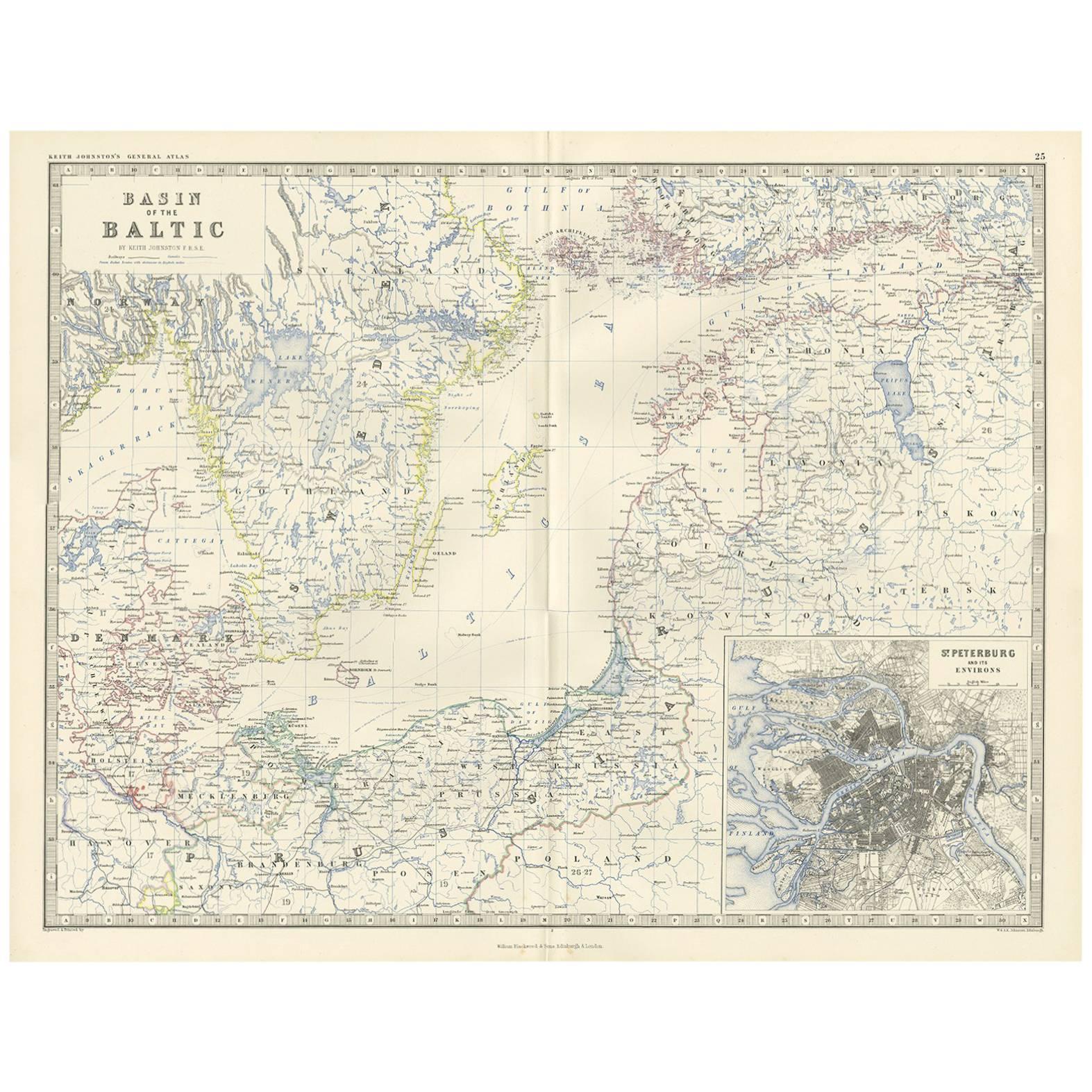
Old Map of the the Baltic Sea Region, Inset of St. Petersburg, 1882
$335.48
$419.3520% Off
£249.74
£312.1820% Off
€280
€35020% Off
CA$459.52
CA$574.4120% Off
A$511.09
A$638.8620% Off
CHF 266.88
CHF 333.5920% Off
MX$6,219.43
MX$7,774.2920% Off
NOK 3,408.41
NOK 4,260.5120% Off
SEK 3,196.49
SEK 3,995.6120% Off
DKK 2,131.54
DKK 2,664.4320% Off
Shipping
Retrieving quote...The 1stDibs Promise:
Authenticity Guarantee,
Money-Back Guarantee,
24-Hour Cancellation
About the Item
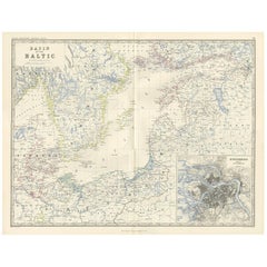
Description: antique map titled 'Basin of the Baltic'. Old map of the regiona round the Baltic Sea. Includes an inset map of St. Petersburg. This map originates from 'The Royal Atlas of Modern Geography, Exhibiting, in a Series of Entirely Original and Authentic Maps, the Present Condition of Geographical Discovery and Research in the Several Countries, Empires, and States of the World' by A.K. Johnston. Published by W. and A.K. Johnston, 1882.
Artists and Engravers: Alexander Keith Johnston LLD (1804-1871) was a Scottish geographer. He was a pupil of the Edinburgh engraver and mapmaker, James Kirkwood. In 1826, he joined his brother William (who would become Sir William Johnston, Lord Provost of Edinburgh) in a printing and engraving business, forming the well-known cartographical firm of W. and A. K. Johnston.
Condition: Good, general age-related toning. Please study image carefully.
About the Seller
5.0
Recognized Seller
These prestigious sellers are industry leaders and represent the highest echelon for item quality and design.
Platinum Seller
Premium sellers with a 4.7+ rating and 24-hour response times
Established in 2009
1stDibs seller since 2017
2,508 sales on 1stDibs
Typical response time: <1 hour
- ShippingRetrieving quote...Shipping from: Langweer, Netherlands
- Return Policy
Authenticity Guarantee
In the unlikely event there’s an issue with an item’s authenticity, contact us within 1 year for a full refund. DetailsMoney-Back Guarantee
If your item is not as described, is damaged in transit, or does not arrive, contact us within 7 days for a full refund. Details24-Hour Cancellation
You have a 24-hour grace period in which to reconsider your purchase, with no questions asked.Vetted Professional Sellers
Our world-class sellers must adhere to strict standards for service and quality, maintaining the integrity of our listings.Price-Match Guarantee
If you find that a seller listed the same item for a lower price elsewhere, we’ll match it.Trusted Global Delivery
Our best-in-class carrier network provides specialized shipping options worldwide, including custom delivery.More From This Seller
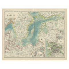
View AllAntique Map of the Surroundings of the Baltic Sea by A.K. Johnston, 1865
Located in Langweer, NL
Antique map titled 'Basin of the Baltic'. Depicting, Denmark, Sweden, Finland, Estonia, Poland, Prussia and more. With an inset map of St. Peterburg and environments. This map origin...
Category
Antique Mid-19th Century Maps
Materials
Paper
$287 Sale Price
20% Off
Antique Map of the Baltic Sea by Johnston, '1909'
Located in Langweer, NL
Antique map titled 'Basin of the Baltic'. Original antique map of Baltic Sea. With inset maps of Kiel, Stettin, Danzig and St Petersburg. This map originate...
Category
Early 20th Century Maps
Materials
Paper
$239 Sale Price
20% Off
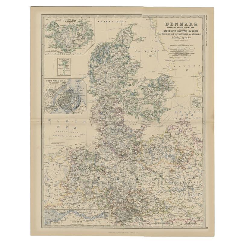
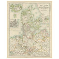
Antique Map of Denmark by Johnston '1909'
Located in Langweer, NL
Antique map titled 'Denmark'. Original antique map of Denmark. With inset maps of Iceland, Faroe Island, and Copenhagen. This map originates from the ‘Royal Atlas of Modern Geography...
Category
Early 20th Century Maps
Materials
Paper
$239 Sale Price
20% Off
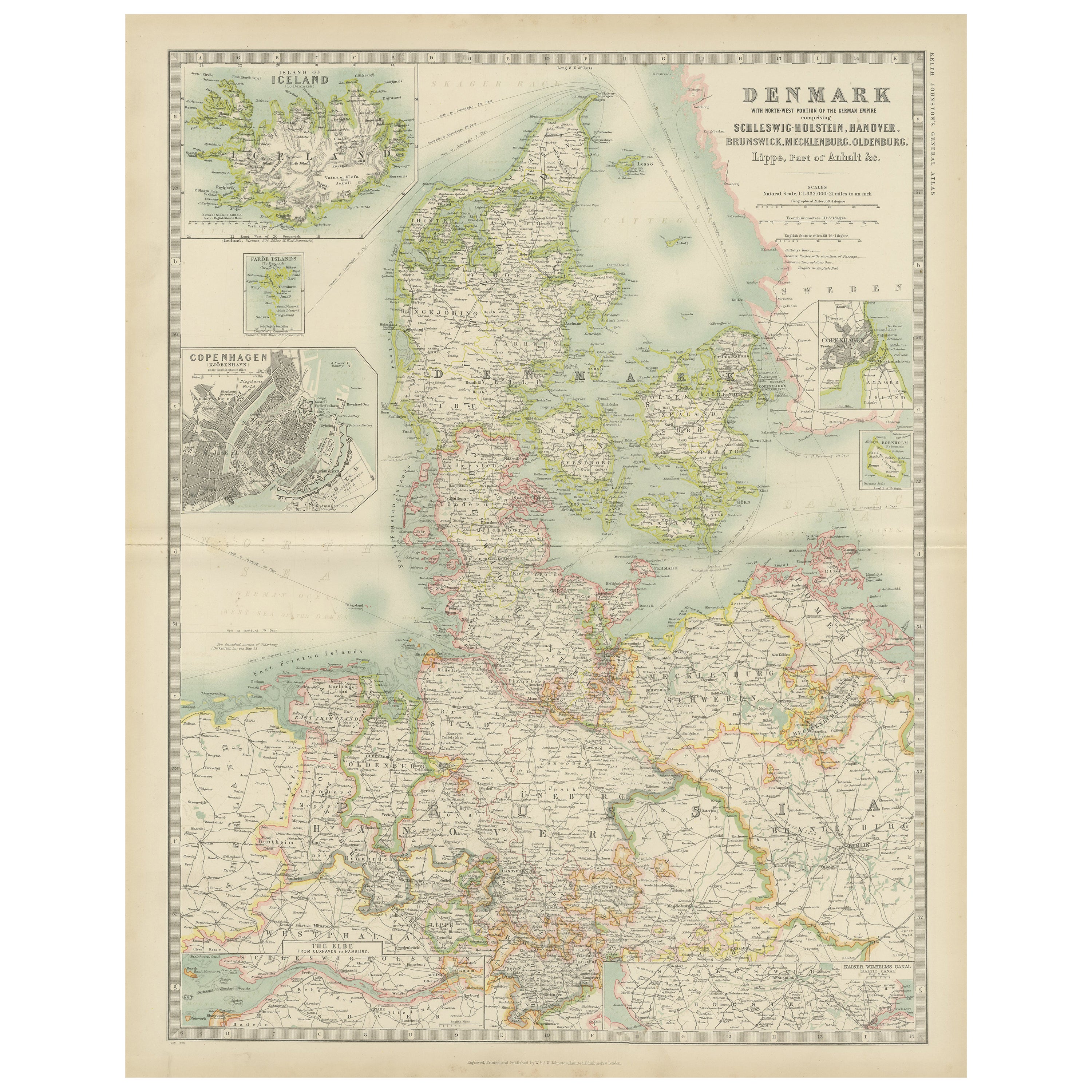
Antique Map of Denmark with Inset Maps of Iceland, Copenhagen and the Elbe, 1882
Located in Langweer, NL
Antique map titled 'Denmark with North-West portion of the German Empire comprising Schleswic-Holstein, Hanover, Brunswick, Meckleburg, Oldenburg, Anhalt, Lippe & c'. Old map of Denm...
Category
Antique 19th Century Maps
Materials
Paper
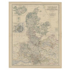
$230 Sale Price
20% Off
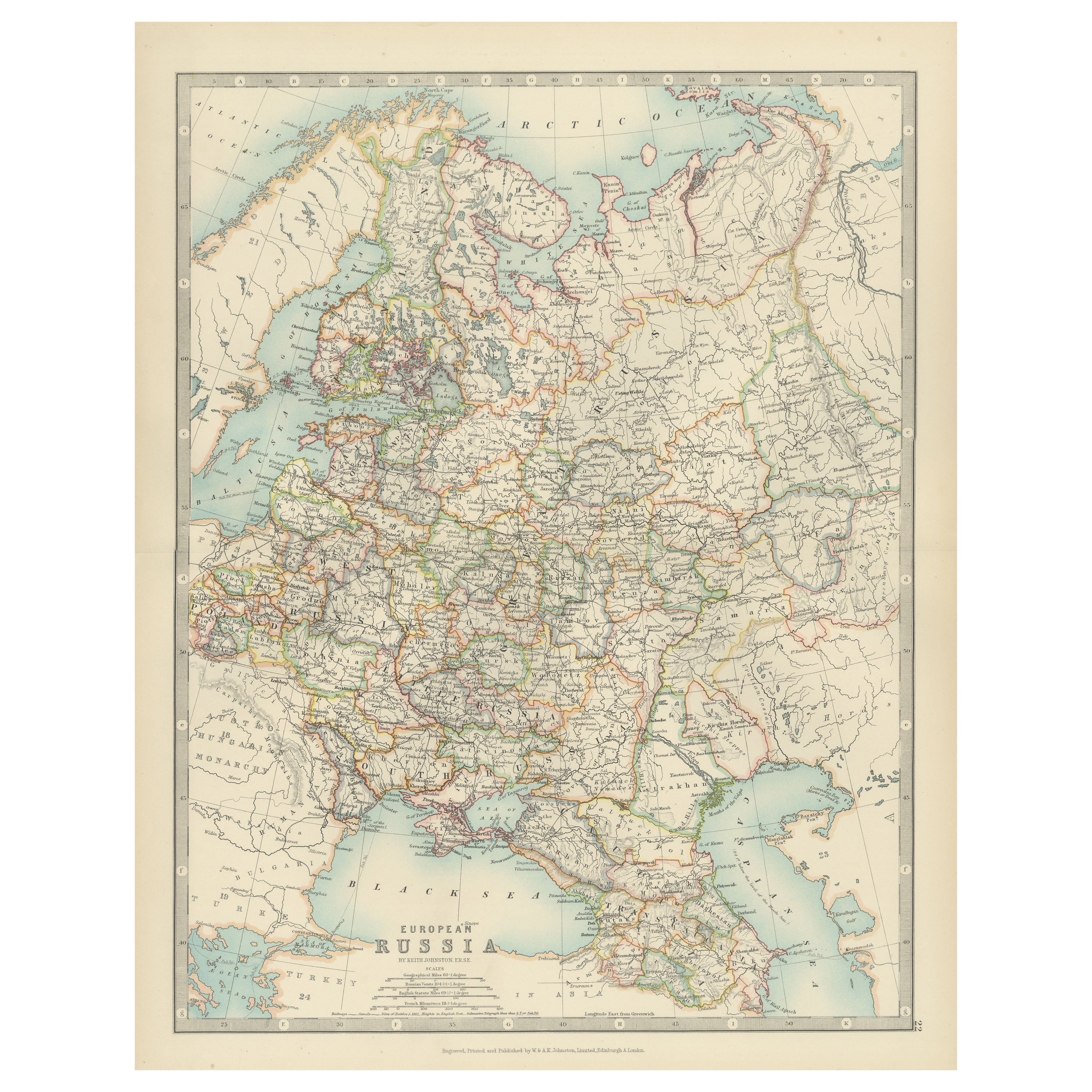
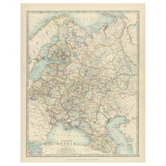
Antique Map of European Russia, 1903, with Colorful Provincial Boundaries
Located in Langweer, NL
Title: Antique Map of European Russia, 1903, with Colorful Provincial Boundaries
Description:
This antique map, titled "European Russia," was engraved and published in 1903 by W. & ...
Category
Early 20th Century Maps
Materials
Paper
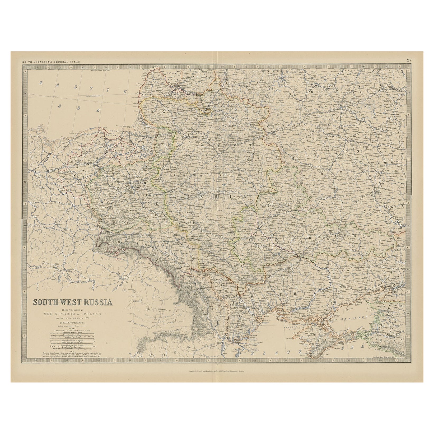
Old Map of Southern Russia, Incl the Extent of the Kingdom of Poland, 1882
Located in Langweer, NL
Antique map titled 'South-West Russia'.
Old map of southern Russia, also showing the extent of the Kingdom of Poland. This map originates from 'The Royal Atlas of Modern Geography...
Category
Antique 1880s Maps
Materials
Paper

$325 Sale Price
20% Off
You May Also Like
Russia in Europe with Poland and Finland. Century Atlas antique vintage map
Located in Melbourne, Victoria
'The Century Atlas. Russia in Europe with Poland and Finland'
Original antique map, 1903.
Central fold as issued. Map name and number printed on the reverse corners.
Sheet 40cm by ...
Category
Early 20th Century Victorian More Prints
Materials
Lithograph

Large Original Antique Map of Poland by Sidney Hall, 1847
Located in St Annes, Lancashire
Great map of Poland
Drawn and engraved by Sidney Hall
Steel engraving
Original colour outline
Published by A & C Black. 1847
Unframed
...
Category
Antique 1840s Scottish Maps
Materials
Paper

Russia, Western and Southern Part. Century Atlas antique vintage map
Located in Melbourne, Victoria
'The Century Atlas. Russia, Western and Southern Part'
Original antique map, 1903.
Inset map tilted 'St Petersburg and Environs'.
Central fold as issued. Map name and number printe...
Category
Early 20th Century Victorian More Prints
Materials
Lithograph

1832 Large Map "Russian & Poland" Ric. R0012
Located in Norton, MA
Large map 1832
"Russian & Poland"
Ric.r0012
Russia & Poland, by J. Arrowsmith. London, pubd. 15 Feby. 1832 by J. Arrowsmith, 35 Essex Street, Strand., ...
Category
Antique 19th Century Unknown Maps
Materials
Paper

Large Original Vintage Map of Sweden and Norway circa 1920
Located in St Annes, Lancashire
Great map of Sweden and Norway
Original color. Good condition
Published by Alexander Gross
Unframed.
Category
Vintage 1920s English Victorian Maps
Materials
Paper

1853 Map of "Russia in Europe Including Poland" Ric.r016
Located in Norton, MA
Description
Russia in Europe incl. Poland by J Wyld c.1853
Hand coloured steel engraving
Dimension: Paper: 25 cm W x 33 cm H ; Sight: 22 cm W x 28 cm H
Condition: Good ...
Category
Antique 19th Century Unknown Maps
Materials
Paper

More Ways To Browse
Gold Cigarette Holder
Portico Clock
Postmodern Karl Springer
Purple Heart Wood Furniture
Red Snuff Bottles
Rococo Secretary
Romano Murano Glass
Russian Empire Table
Safari Table
Sail Race
Sawyer Made
Shabbat Candle
Shaker Chest
Silk Headboard
Spinach Jade
Takahama Kazuhide Table
Tapio Wirkkala Bird
Teak Mirror With Shelf