Items Similar to Rare Antique Map of the Imperial Court in Peking China, 1665

Want more images or videos?
Request additional images or videos from the seller
1 of 10
Rare Antique Map of the Imperial Court in Peking China, 1665
$531.65
£398.51
€450
CA$730.40
A$815.42
CHF 427.27
MX$9,981.60
NOK 5,426.34
SEK 5,116.35
DKK 3,425.56
Shipping
Retrieving quote...The 1stDibs Promise:
Authenticity Guarantee,
Money-Back Guarantee,
24-Hour Cancellation
About the Item
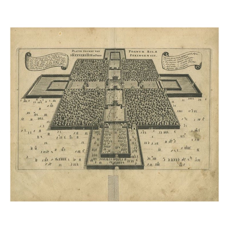
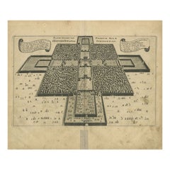
Antique print titled 'Platte Grondt van s Keysers Hof in Pekin. Forme de la Cour Imperiale de Peking'. This print originates from 'Joan Nieuhof, Het Gezandschap Der Neêrlandtsche Oost-Indische Compagnie, aan den grooten Tartarischen Cham.'
- Dimensions:Height: 12.01 in (30.5 cm)Width: 14.61 in (37.1 cm)Depth: 0.02 in (0.5 mm)
- Materials and Techniques:Paper,Engraved
- Place of Origin:
- Period:Mid-17th Century
- Date of Manufacture:1665
- Condition:Minor fading. Please study image carefully.
- Seller Location:Langweer, NL
- Reference Number:Seller: BGI-005641stDibs: LU305439929441
About the Seller
5.0
Recognized Seller
These prestigious sellers are industry leaders and represent the highest echelon for item quality and design.
Platinum Seller
Premium sellers with a 4.7+ rating and 24-hour response times
Established in 2009
1stDibs seller since 2017
2,511 sales on 1stDibs
Typical response time: <1 hour
- ShippingRetrieving quote...Shipping from: Langweer, Netherlands
- Return Policy
Authenticity Guarantee
In the unlikely event there’s an issue with an item’s authenticity, contact us within 1 year for a full refund. DetailsMoney-Back Guarantee
If your item is not as described, is damaged in transit, or does not arrive, contact us within 7 days for a full refund. Details24-Hour Cancellation
You have a 24-hour grace period in which to reconsider your purchase, with no questions asked.Vetted Professional Sellers
Our world-class sellers must adhere to strict standards for service and quality, maintaining the integrity of our listings.Price-Match Guarantee
If you find that a seller listed the same item for a lower price elsewhere, we’ll match it.Trusted Global Delivery
Our best-in-class carrier network provides specialized shipping options worldwide, including custom delivery.More From This Seller
View AllOriginal Antique Print of the Imperial Palace in Beijing, China, 1668
Located in Langweer, NL
Antique print titled 'Platte Grondt van s Keysers Hof in Pekin - Pdanum Aulae Penigensis'. Old print of the Imperial Palace in Beijing, China. Originates from Niehof's Latin edition ...
Category
Antique 17th Century Prints
Materials
Paper
Antique Map of Cities of the Province of Shanxi in China, 1749
By Jacques-Nicolas Bellin
Located in Langweer, NL
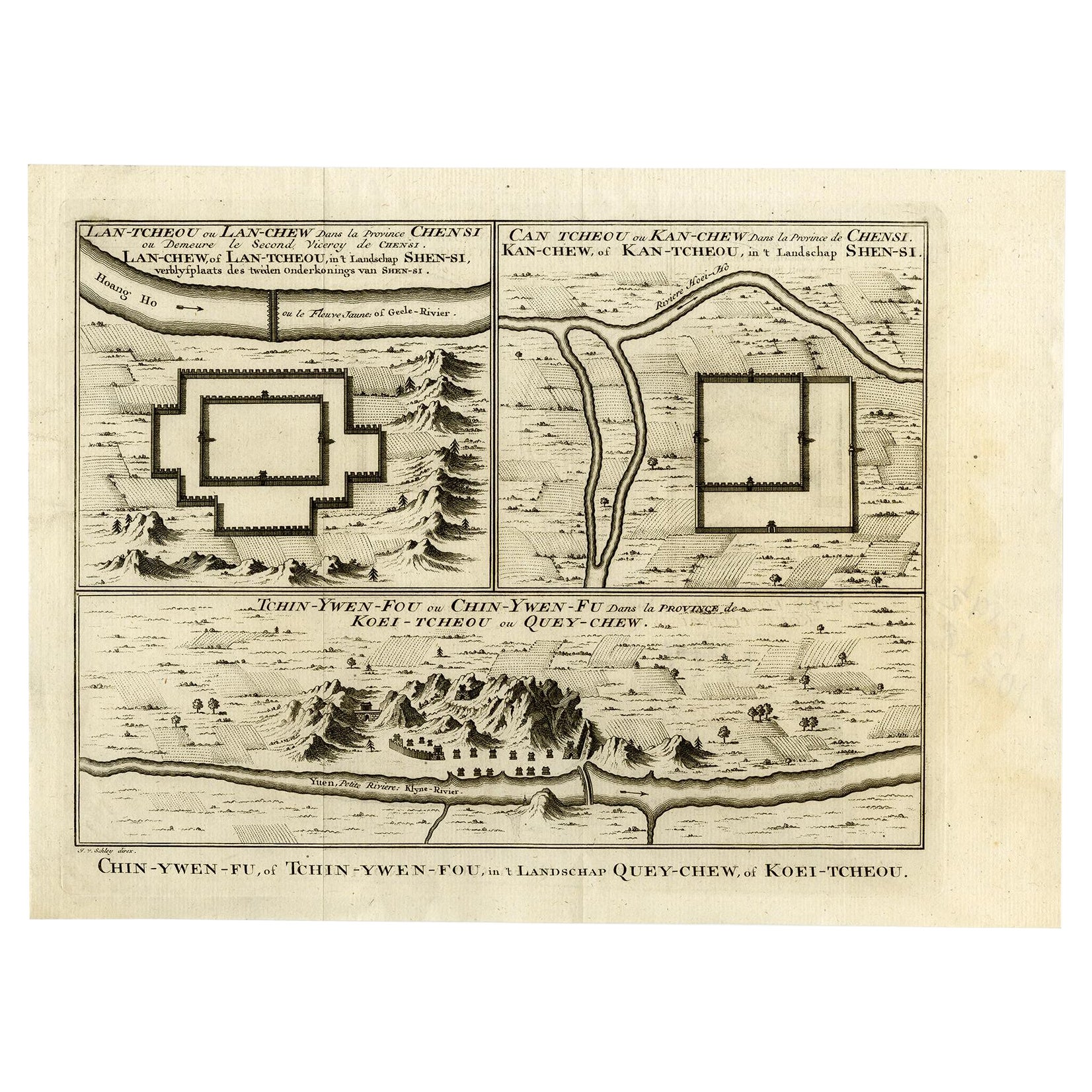
Antique print titled: 'Lan-Tcheou ou Lan-Chew dan la province Chensi; Can Tcheou ou Kan-Chew dan la province de Chensi; Tchin-Ywe-Fou ou Chin-Ywen-Fu dans la province de Koei-Tcheou ...
Category
Antique 18th Century Maps
Materials
Paper

$236 Sale Price
20% Off
Antique Map of the Cities of the Qing Dynasty Provinces in China, 1738
Located in Langweer, NL
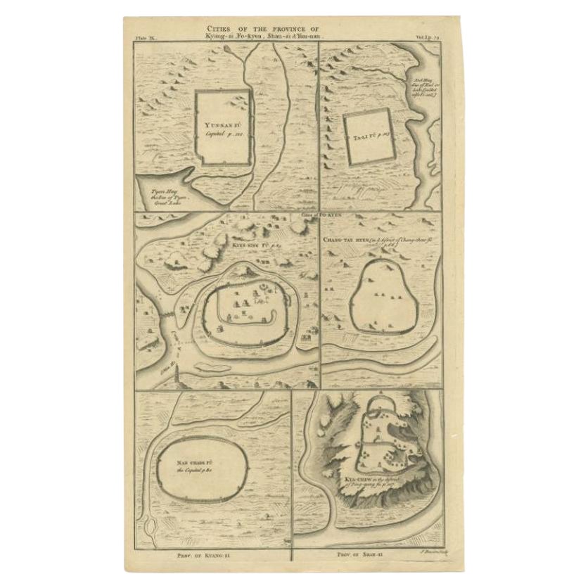
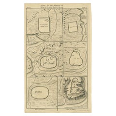
Antique print titled 'Cities of the Province of Kyang-si, Fo-kyen, Shan-Si & Yun-nan'. Old map depicting four walled cities of the Chinese Qing dynasty provinces Yunnan, Shanxi, Fuji...
Category
Antique 18th Century Maps
Materials
Paper
$245 Sale Price
20% Off
1749 Jacques Nicolas Bellin Map of the Great Wall of China Near Kiang-nan fu
Located in Langweer, NL
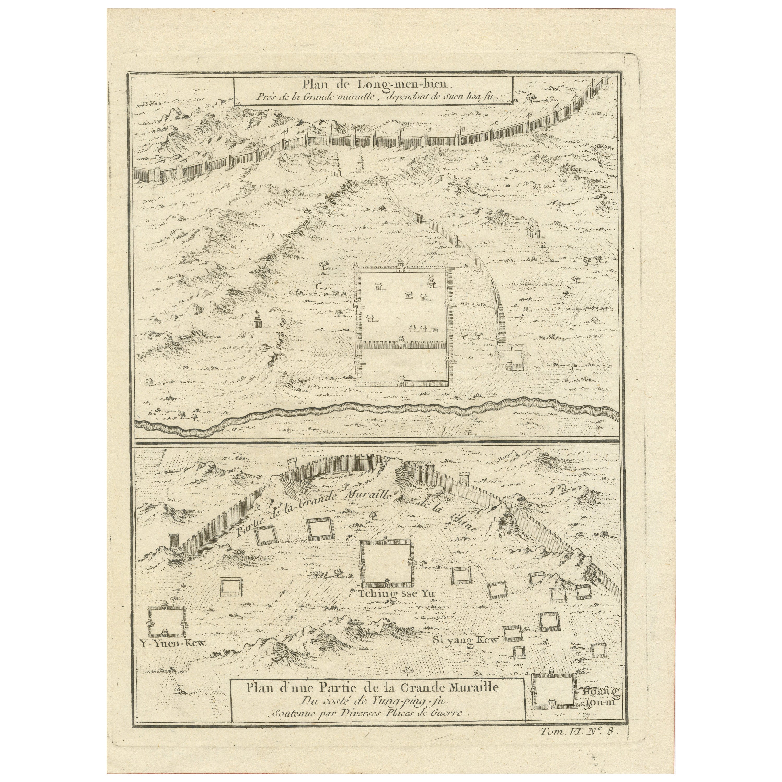
This original antique image is an historical map by Jacques Nicolas Bellin, depicting the Great Wall of China as it was understood in the mid-18th century.
The map includes French ...
Category
Antique 1750s Prints
Materials
Paper

$141 Sale Price
20% Off
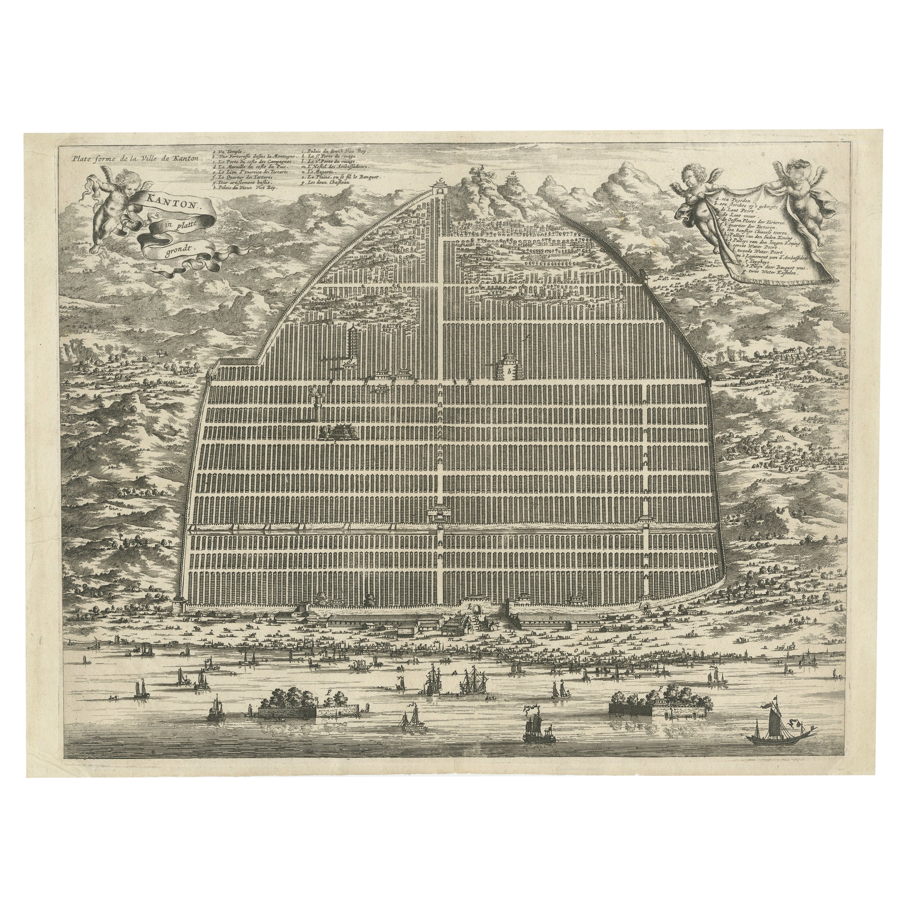
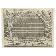
17th Century Cartographic Marvel: A Detailed Engraving of Guangzhou (Kanton)
Located in Langweer, NL
This engraving of Guangzhou ("Kanton") is from a French edition of Olfert Dapper's work. The French edition titled "Description de l’Empire de la Chine" was published in 1674. It is ...
Category
Antique 1670s Maps
Materials
Paper
$1,039 Sale Price
20% Off
Free Shipping
Antique Map of Three Chinese Cities in Chensi and Koei Tcheou, c.1758
Located in Langweer, NL
Antique map titled 'Lan-Tcheou ou Lan-Chew dan la province Chensi; Can Tcheou ou Kan-Chew dan la province de Chensi; Tchin-Ywe-Fou ou Chin-Ywen-Fu dans la province de Koei-Tcheou ou Quey-chew.' Three plans of old Chinese cities...
Category
Antique 18th Century Maps
Materials
Paper

$264 Sale Price
20% Off
You May Also Like
17th-18th Century Siege of Graves Mapping Engraving By Willian III
Located in Kingston, NY
RARE French 17th-18th Century Enhanced Siege of Graves Mapping Engraving BY William III, also widely known as William of Orange,
The Siege of Grave in Dutch Brabant started by Monsie...
Category
Antique 17th Century French Prints
Materials
Paper

1627 Hendrik Hondius Map Entitled "Vltoniae Orientalis Pars, " Ric.a009
Located in Norton, MA
1627 Hendrik Hondius map entitled
"Vltoniae orientalis pars,"
Ric.a009
Title:
Vltoniae orientalis : pars
Title (alt.) :
Ultoniae orientalis pars
Creator:
Mercator, Gerh...
Category
Antique 17th Century Dutch Maps
Materials
Paper

1633 Map "La Souverainete De Sedan Et De Raucourt, Et La Prevoste Ric0011
Located in Norton, MA
1653 map entitled
"La Souverainete de Sedan et de Raucourt, et la Prevoste de Doncheri,"
Ric0011
Description:
Lovely map centered on Sedan and Doncheri and the Meuze River fr...
Category
Antique 17th Century Dutch Maps
Materials
Paper

Super Rare Antique French Map of Chine and the Chinese Empire, 1780
Located in Amsterdam, Noord Holland
Super Rare Antique French Map of Chine and the Chinese Empire, 1780
Very nice map of Asia. 1780 Made by Bonne.
Additional information:
Type: Map
...
Category
Antique 18th Century European Maps
Materials
Paper

$584 Sale Price
32% Off
Antique French Map of Asia Including China Indoneseia India, 1783
Located in Amsterdam, Noord Holland
Very nice map of Asia. 1783 Dedie au Roy.
Additional information:
Country of Manufacturing: Europe
Period: 18th century Qing (1661 - 1912)
Condition: Overall Condition B (Good Used)...
Category
Antique 18th Century European Maps
Materials
Paper

$648 Sale Price
20% Off
1635 Willem Blaeu Map of Northern France"Comitatvs Bellovacvm" Ric.a08
Located in Norton, MA
1635 Willem Blaeu map of northern France, entitled.
"Comitatvs Bellovacvm Vernacule Beavvais,"
Colored
Ric.a008
“COMITATVS BELLOVACVM…” Amsterdam: W...
Category
Antique 17th Century Unknown Maps
Materials
Paper

More Ways To Browse
Imperial Mid
Giacometti Bust
Gio Ponti Bar Cart
Gold Iron Bed
Greek Oil Jar
Hampton And Sons
Hotel Silver Tea Set
Jansen Drinks Table
Limoges France Tea Set
Mercury Pendulum Clock
P110 Canada
Pair Brass Cranes
Pair Bronze Cranes
Pair Of Recumbent Lions
Palissy Ware
Panther Statue
Paul Jacoulet Woodblock Prints
Paul Mccobb Handles