Items Similar to Antique Map of Three Chinese Cities in Chensi and Koei Tcheou, c.1758

Want more images or videos?
Request additional images or videos from the seller
1 of 5
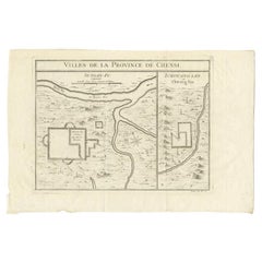
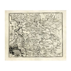
Antique Map of Three Chinese Cities in Chensi and Koei Tcheou, c.1758
About the Item
Antique map titled 'Lan-Tcheou ou Lan-Chew dan la province Chensi; Can Tcheou ou Kan-Chew dan la province de Chensi; Tchin-Ywe-Fou ou Chin-Ywen-Fu dans la province de Koei-Tcheou ou Quey-chew.' Three plans of old Chinese cities. While these maps by Van Schley after Bellin were initially made for 'Histoire Generale des Voyages' (Paris 1746-1759), this is from the 1758 Dutch edition of that work published by Arkstee & Merkus.
Artists and Engravers: Made by 'Jakob van Schley' after 'Jacques Nicolas Bellin'. Jakob van der Schley (1715-1779) was a Dutch draughtsman and engraver, who studied under Bernard Picart. Jacques-Nicolas Bellin (1703-1772) was a French hydrographer, geographer and member of The Philosophes. His career, spanning over 50 years, caused an enormous outpt in maps, particular of maritime interest.
Condition: Excellent, given age. Original folds, as issued. General age-related toning and/or occasional minor defects from handling. Please study image carefully.
Date: 1758
Overall size: 33.2 x 24.3 cm.
Image size: 28.6 x 22.5 cm.
We sell original antique maps to collectors, historians, educators and interior decorators all over the world. Our collection includes a wide range of authentic antique maps from the 16th to the 20th centuries. Buying and collecting antique maps is a tradition that goes back hundreds of years. Antique maps have proved a richly rewarding investment over the past decade, thanks to a growing appreciation of their unique historical appeal. Today the decorative qualities of antique maps are widely recognized by interior designers who appreciate their beauty and design flexibility. Depending on the individual map, presentation, and context, a rare or antique map can be modern, traditional, abstract, figurative, serious or whimsical. We offer a wide range of authentic antique maps for any budget.
- Dimensions:Height: 9.57 in (24.3 cm)Width: 13.08 in (33.2 cm)Depth: 0 in (0.01 mm)
- Materials and Techniques:
- Period:
- Date of Manufacture:1758
- Condition:
- Seller Location:Langweer, NL
- Reference Number:
About the Seller
5.0
Platinum Seller
These expertly vetted sellers are 1stDibs' most experienced sellers and are rated highest by our customers.
Established in 2009
1stDibs seller since 2017
1,947 sales on 1stDibs
Typical response time: <1 hour
- ShippingRetrieving quote...Ships From: Langweer, Netherlands
- Return PolicyA return for this item may be initiated within 14 days of delivery.
More From This SellerView All
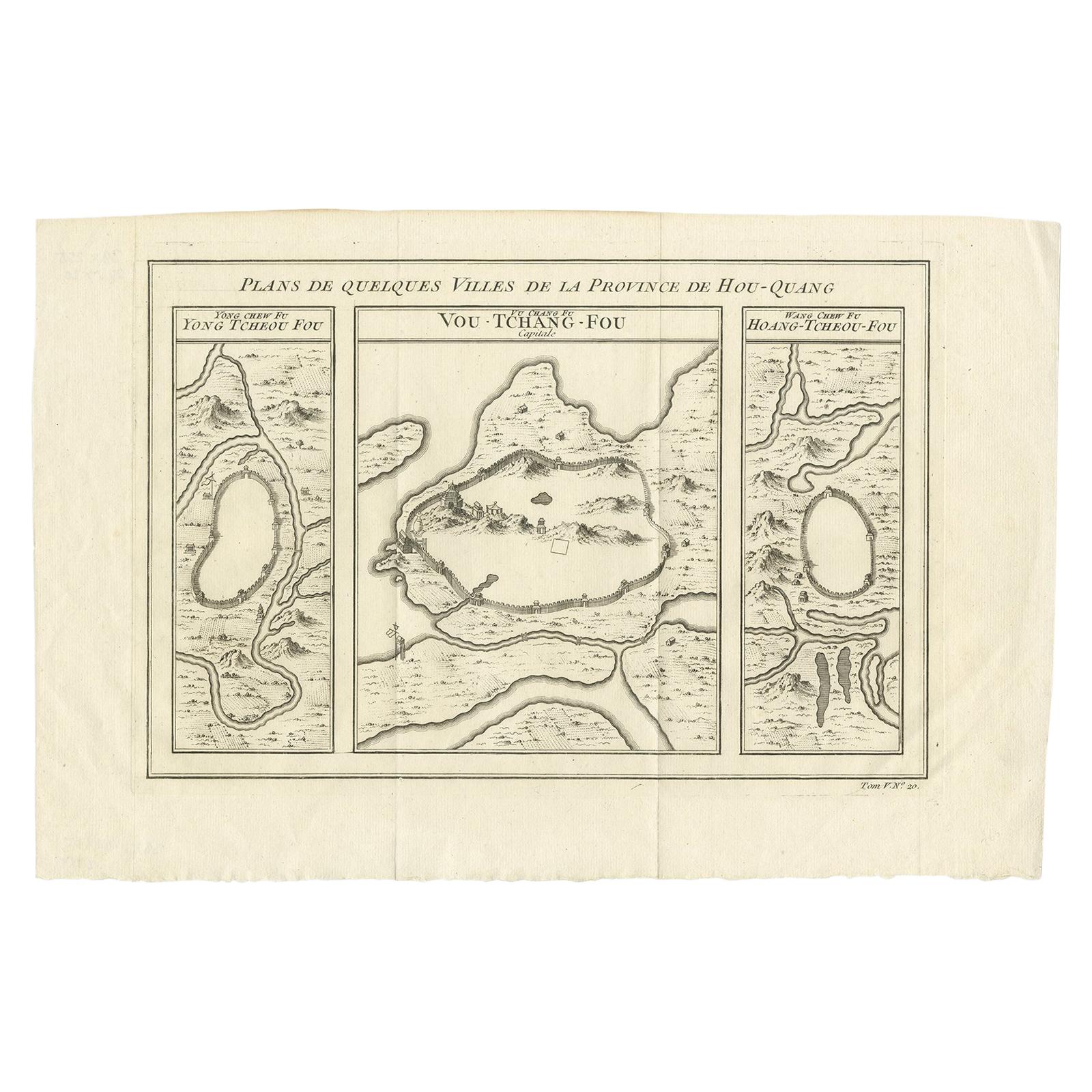
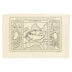
- Antique Map of Cities in the Region of Hubei in China, 1758Located in Langweer, NLAntique map titled 'Plans de Quelques villes de la province de Hou-Quang.' Three plans of cities in a region named Hou-Quang (currently Hubei). While these maps by Van Schley after B...Category
Antique 18th Century Maps
MaterialsPaper
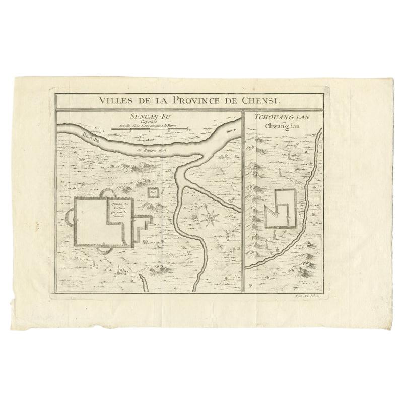
- Antique Map of Two Cities in the Province of Shanxi or Chensi, China, 1748By Jacques-Nicolas BellinLocated in Langweer, NLAntique map China titled ‘Villes de la Province de Chensi’. Interesting set of two local town plans of ""Si-Ngan-Fu: Capitale."" and ""Tchang Lan, Ou...Category
Antique 18th Century Maps
MaterialsPaper
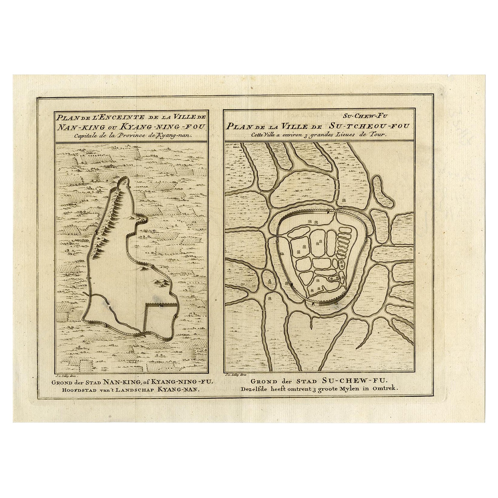
- Antique Map of Cities Nanking and Suzhou in the Jiangsu Region, China, c.1758Located in Langweer, NLAntique map titled 'Plan de l' Enceinte de la Ville de Nan-King ou Kyang-Ning-Fou et plan de la ville de Su-Tcheou-Fou.' A map of the city of Nanking or Nanjing. A second map shows S...Category
Antique 18th Century Maps
MaterialsPaper
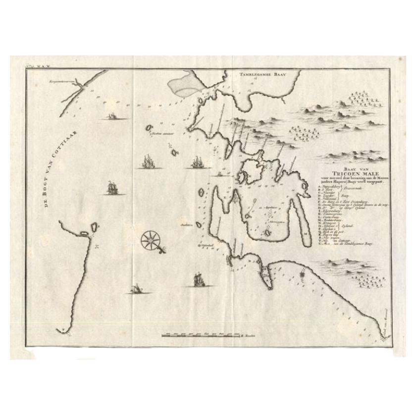
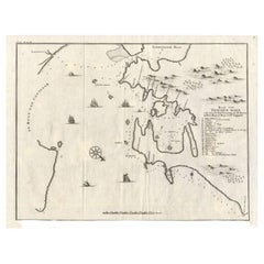
- Antique Map of Trincomalee and Tambalagam Bay, 1758Located in Langweer, NLAntique map titled 'Bay de Trinquemale'. Map of Trincomalee and Tambalagam Bay in Sri Lanka. While these maps by Van Schley after Bellin were initially made for 'Histoire Generale de...Category
Antique 18th Century Maps
MaterialsPaper
- Antique Map of Three Cities of China's Hubei and Hunan Provinces by BellinBy Jacques-Nicolas BellinLocated in Langweer, NLAntique print titled 'Plans de Quelques villes de la province de Hou-Quang.' Three bird's-eye view plans of walled cities in what are now China's Hubei (Hou-Quang) and Hunan Province...Category
Antique Mid-18th Century Maps
MaterialsPaper
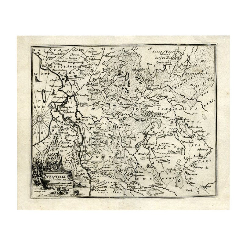
- Antique Map of Overijssel by Bachiene, 1758Located in Langweer, NLAntique map titled 'Over-Yssel'. Map of the Overijssel, the Netherlands. This map originates from 'Kort begrip der Oude en Nieuwe Staatkundige Geographie', by W.A. Bachiene, publishe...Category
Antique 18th Century Maps
MaterialsPaper


You May Also Like
- Antique Map of American Cities, Vignette of New York City, circa 1920Located in St Annes, LancashireGreat maps of American Cities Unframed Original color By John Bartholomew and Co. Edinburgh Geographical Institute Published, circa 1920Category
Vintage 1920s British Maps
MaterialsPaper
- Original Antique Map of China, Arrowsmith, 1820Located in St Annes, LancashireGreat map of China Drawn under the direction of Arrowsmith Copper-plate engraving Published by Longman, Hurst, Rees, Orme and Brown, 1820 Unfr...Category
Antique 1820s English Maps
MaterialsPaper
- Framed Map of ChinaLocated in Greenwich, CTMap of China, 19th century. European print map of China Conservation frame with walnut frame Overall dimension : 28 1/2" wide 31" high 2" depth with fra...Category
Antique 19th Century European Qing Prints
MaterialsPaper
- Large Original Antique Map of China, Fullarton, C.1870Located in St Annes, LancashireGreat map of China From the celebrated Royal Illustrated Atlas Lithograph by Swanston. Original color. Published by Fullarton, Edinburgh. C.1870 Repairs to minor edge te...Category
Antique 1870s Scottish Maps
MaterialsPaper
- Original Antique Map / City Plan of Brussels by Tallis, circa 1850Located in St Annes, LancashireGreat map of Brussels. Steel engraving. Published by London Printing & Publishing Co. (Formerly Tallis), C.1850 Free shipping.Category
Antique 1850s English Maps
MaterialsPaper
- Original Antique Map of China by Thomas Clerk, 1817Located in St Annes, LancashireGreat map of China Copper-plate engraving Drawn and engraved by Thomas Clerk, Edinburgh. Published by Mackenzie And Dent, 1817 Unframed.Category
Antique 1810s English Maps
MaterialsPaper


Recently Viewed
View AllMore Ways To Browse
Chinese Hundred Antiques
Antique City Plans
Antique Chinese 16th
16th Century Chinese Antiques
Old Map Of Paris
Old Map Paris
Antique Map China
Antique China Map
Antique Chinese Maps
Antique Maps Of China
Antique Map Of China
Paris City Maps
Chinese Antique Map
Dutch Maritime
Old Paris China
Maritime Map
Date Kan
Antique Maps Of London