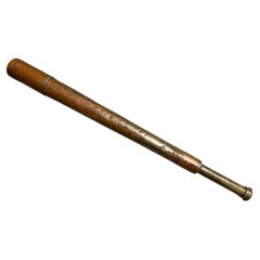
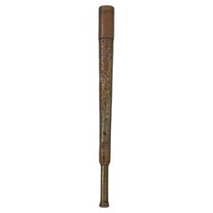
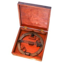
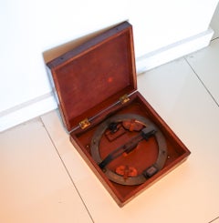
Maritime Map

8
to
31
226
27
156
106
59
48
46
46
40
33
22
20
18
17
15
13
12
11
9
8
8
6
6
5
5
5
4
4
4
3
3
3
2
2
2
2
2
2
2
1
1
1
1
1
1
1
1
34
22
5
4
4
Sort By
1856 U.S. Coast Survey Map of Chesapeake Bay and Delaware Bay
Located in Colorado Springs, CO
Presented is U.S. Coast Survey nautical chart or maritime map of Chesapeake Bay and Delaware Bay
Category

Antique 1850s American Maps

Materials

Paper

Large Original Vintage Map of the Maritimes, Canada, circa 1920
Located in St Annes, Lancashire
Great map of The Maritime provinces Unframed Original color By John Bartholomew and Co
Category

Vintage 1920s British Maps

Materials

Paper

Map of Polynesia Highlighting Cultural Landscapes and Maritime Activities, 1851
Located in Langweer, NL
John Tallis & Company was a London-based map publisher that flourished during the 19th century
Category

Antique 1850s Maps

Materials

Paper

Antique Map of the Mouth of the Chiang River by Bellin, 1764
By Jacques-Nicolas Bellin
Located in Langweer, NL
Bellin's "Le Petit atlas maritime". Map retains its natural black and white dark impression. Artists and
Category

Antique 18th Century Maps

Materials

Paper

Maritime and Terrestrial Survey of Spanish Santander in 1901, An Original Map
Located in Langweer, NL
This antique map is a historical map of the province of Santander (currently known as Cantabria
Category

Antique Early 1900s Maps

Materials

Paper

Alicante in a 1901 Antique Map: Maritime Gateway of Spain's Costa Blanca
Located in Langweer, NL
An original antique map of the province of Alicante, dated 1901. It is part of the atlas series by
Category

Antique Early 1900s Maps

Materials

Paper

La Coruña 1901: A Cartographic View of Galicia's Maritime Province
Located in Langweer, NL
This antique map for sale showcases the province of La Coruña (in Galician, A Coruña), located in
Category

Antique Early 1900s Maps

Materials

Paper

Circa 1940 Original Political poster - To defend the imperial heritage - Colony
Located in PARIS, FR
. It shows a sailor standing at attention, protecting a maritime map of southern Europe and Africa
Category

1940s Prints and Multiples

Materials

Paper, Lithograph

Antique Map of Grenada, West Indies, 1758
Located in Langweer, NL
very good condition, this map hails from Bellin's 'Petit Atlas Maritime,' showcasing the cartographic
Category

Antique 1750s Maps

Materials

Paper

Antique Map of Grenada, West Indies, 1758
No Reserve
H 9.85 in W 7.09 in D 0.01 in
Antique Map of Ambon Island, Indonesia, 1756
Located in Langweer, NL
Philosophes. His career, spanning over 50 years, caused an enormous output in maps, particular of maritime
Category

Antique 18th Century Maps

Materials

Paper

Antique Map of France with Decorative Title Cartouche
Located in Langweer, NL
Antique map titled 'Carte de la France'. Original old map of France. This map originates from 'Le
Category

Antique Mid-18th Century Maps

Materials

Paper

Antique Map of Guyenne, Gascony and Béarn, France
Located in Langweer, NL
), Gascony and Béarn, France. This map originates from 'Le Petit Atlas Maritime Recueil De Cartes et Plans
Category

Antique Mid-18th Century Maps

Materials

Paper

Antique Map of the Bay of Brusc, France
Located in Langweer, NL
Antique map titled 'Carte de la rade du Brusc'. Original map of the bay of Brusc, France. This map
Category

Antique Mid-18th Century Maps

Materials

Paper

Antique Map of the Bay of Brusc, France
H 12.49 in W 8.98 in D 0.02 in
Antique Map of Sumatra by Bellin, 1764
Located in Langweer, NL
Straits of Malacca, including Singapore. This map originates from 'Le Petit Atlas Maritime Recueti de
Category

Antique 18th Century Maps

Materials

Paper

Antique Map of Sumatra by Bellin, 1764
H 12.8 in W 17.13 in D 0 in
Antique Map of the Coast of Roussillon, France
Located in Langweer, NL
map of the coast of Roussillon, France. This map originates from 'Le Petit Atlas Maritime (..)' by J.N
Category

Antique Mid-18th Century Maps

Materials

Paper

Antique Map of the Region of Martigues, France
Located in Langweer, NL
features and surroundings of Martigues during the 18th century. The map is part of "Le Petit Atlas Maritime
Category

Antique Mid-18th Century Maps

Materials

Paper

Antique Map of Novaya Zemlya by Bellin, 1758
Located in Langweer, NL
maps, particular of maritime interest. He was appointed the first Ingenieur Hydrographe de la Marine
Category

Antique 18th Century Maps

Materials

Paper

Antique Map of the Region of Fréjus, France
Located in Langweer, NL
Title: "Golf de Fréjus" Description: This antique map, titled "Golf de Fréjus," is an original
Category

Antique Mid-18th Century Maps

Materials

Paper

Antique Map of the Region of Fréjus, France
H 12.49 in W 8.98 in D 0.02 in
Historical Map Depicting the Continent of Asia, 1882
Located in Langweer, NL
Asia. Furthermore, the map features maritime lines and oceanic depths, indicating the knowledge and
Category

Antique 1880s Maps

Materials

Paper

Antique Map of Trincomalee and Tambalagam Bay, 1758
Located in Langweer, NL
over 50 years, caused an enormous outpt in maps, particular of maritime interest. Condition: Good
Category

Antique 18th Century Maps

Materials

Paper

Antique Map of the Adour River, Near Bayonne, France
Located in Langweer, NL
of the Adour river, near Bayonne, France. This map originates from 'Le Petit Atlas Maritime (..)' by
Category

Antique Mid-18th Century Maps

Materials

Paper

Antique Map of Boulogne-sur-Mer by Bellin '1764'
Located in Langweer, NL
. This map originates from 'Le petit atlas maritime: recueil de cartes et plans des quatre parties du
Category

Antique Mid-18th Century Maps

Materials

Paper

Decorative Antique Map of Eastern Canada, Published in 1882
Located in Langweer, NL
This is a historical map from the 1882 Blackie Atlas, focused on eastern Canada and the maritime
Category

Antique 1880s Maps

Materials

Paper

Decorative Antique Map of Eastern Canada, Published in 1882
Free Shipping
H 14.97 in W 22.45 in D 0 in
Antique Map of the Queen Charlotte Islands, Haida Gwaii
Located in Langweer, NL
Antique map titled 'Isles de la Reine Charlotte (..)'. Original old map of the Queen Charlotte
Category

Antique Late 18th Century Maps

Materials

Paper

Original 1882 Map of Arabia, Red Sea & Persian Gulf
Located in Langweer, NL
This print is a historically significant map titled "Arabia, the Red Sea, and the Persian Gulf
Category

Antique 1880s Maps

Materials

Paper

Antique Map of the Region of Berre-l'Étang, France
Located in Langweer, NL
of Berre-l'Étang, France. This map originates from 'Le Petit Atlas Maritime (..)' by J.N. Bellin
Category

Antique Mid-18th Century Maps

Materials

Paper

Cartographic Tapestry: Antique Map of Asia Minor, circa 1640
Located in Langweer, NL
Title: "Historical Tapestry: Antique Map of Asia Minor, circa 1640" Description: This authentic
Category

Antique Mid-17th Century Maps

Materials

Paper

Antique Decorative Coloured Map of South Africa and Madagascar, 1882
Located in Langweer, NL
The map of South Africa is from the Blackie & Son Atlas, published in 1882. This historical map is
Category

Antique 1880s Maps

Materials

Paper

Antique Map of Hondarribia Near the Bidasoa River, France & Spain
Located in Langweer, NL
Antique map titled 'Plan de Fontarabie et de la redoute d'Andaye'. Original old map of Hondarribia
Category

Antique Mid-18th Century Maps

Materials

Paper

Roseaux, St. Lucia Island Map by BELLIN, Handcolored Engraving, 1763
Located in Langweer, NL
part of Bellin's renowned "Petit atlas maritime," this map showcases an exquisite depiction of the
Category

Antique 1760s Maps

Materials

Paper

Original Antique Coloured Map of Western Africa, Published in 1882
Located in Langweer, NL
This is a map of Western Africa from the 1882 Blackie & Son atlas. The map details the West African
Category

Antique 1880s Maps

Materials

Paper

Ancient Iberia: Hispania Map from Spruner-Menke Atlas Antiquus, 1880
Located in Langweer, NL
This map is titled "HISPANIA," indicating it is a historical map of ancient Spain. It is an
Category

Antique 1880s Maps

Materials

Paper

Italian Parchment Map of the City of Pisa Dated, 1640
By Matthäus Merian the Elder
Located in Roma, IT
An antique map of the Tuscan city of Pisa engraved for The 'Itinerarium Italiæ Nov-antiquæ' by
Category

Antique 1640s Italian Maps

Materials

Paper

1797 Tardieu Map of Southeast Asia: The Malay Archipelago and Beyond
Located in Langweer, NL
interested in maritime history, cartographic art, and regional maps of Asia, enhancing the allure and
Category

Antique 1790s Maps

Materials

Paper

Antique Map of the Bukhari Region by Van Schley, 1758
Located in Langweer, NL
maps, particular of maritime interest. Artist: Made by 'Jakob van Schley' after 'Jacques Nicolas
Category

Antique 18th Century Maps

Materials

Paper

Stunning Large Scale Antique Map of Martinique, Rare, Published 1758
Located in Langweer, NL
published Petit Atlas Maritime in five volumes which contained several hundred maps. Among his other works
Category

Antique 18th Century Maps

Materials

Paper

Antique Map of the Coast of France Between Brest and Bayonne
Located in Langweer, NL
coast of France between Brest and Bayonne. This map originates from 'Le Petit Atlas Maritime Recueil De
Category

Antique Mid-18th Century Maps

Materials

Paper

Colorful Detailed Antique Map of The World on Mercators Projection, 1882
Located in Langweer, NL
tracks between major ports, this map doesn't just depict landmasses but also reveals the vital maritime
Category

Antique 1880s Maps

Materials

Paper

Antique Map of the Region of Aigues-Mortes and Camargue, France
Located in Langweer, NL
the region of Aigues-Mortes and Camargue, France. This map originates from 'Le Petit Atlas Maritime
Category

Antique Mid-18th Century Maps

Materials

Paper

Antique Map of the Languedoc Canal, Between Touloouse and Marseillette, France
Located in Langweer, NL
Antique map titled 'Carte du canal de Languedoc depuis Toulouse jusqu'a I'etang de Marceillette
Category

Antique Mid-18th Century Maps

Materials

Paper

Cortesi's Masterpiece: A Comprehensive and Authoritative Map of Uruguay, 1903
Located in Langweer, NL
information provided is truly profound, and renders the map fit for use in maritime commerce. In 1901, the
Category

Early 20th Century Maps

Materials

Paper

Antique Map of the Caspian Sea and Surroundings by Bellin, 1764
Located in Langweer, NL
Caspian Sea. This map originates from 'Le Petit Atlas Maritime Recueil De Cartes et Plans' by J.N. Bellin
Category

Antique 18th Century Maps

Materials

Paper

19th Century Illustrated Map of Ceylon (Sri Lanka) with Notable Landmarks
Located in Langweer, NL
John Tallis & Company is known for producing maps and atlases that were highly regarded for their
Category

Antique 1850s Maps

Materials

Paper

Antique Map of the Island Anjouan by Van Schley, c.1750
Located in Langweer, NL
, spanning over 50 years, caused an enormous outut in maps, particular of maritime interest. He was appointed
Category

Antique 18th Century Maps

Materials

Paper

Mediterranean Tapestry: A 19th Century Map of the Mediterranean Shores, 1882
Located in Langweer, NL
This map, titled "The Shores of the Mediterranean," is part of the 1882 atlas by Blackie & Son, and
Category

Antique 1880s Maps

Materials

Paper

Antique Map of Côtes du Nord ‘France’ by V. Levasseur, 1854
By Victor Levasseur
Located in Langweer, NL
Antique map titled 'Dépt. des Côtes du Nord'. Map of the French department of Cotes du Nord, a
Category

Antique Mid-19th Century Maps

Materials

Paper

Antique Map of the Caribbean Island of St Kitts, ca.1750
Located in Langweer, NL
. His career, spanning over 50 years, caused an enormous outpt in maps, particular of maritime interest
Category

Antique 1750s Maps

Materials

Paper

Antique Map of British North America, The Dominion of of Canada, 1882
Located in Langweer, NL
This map is titled "British North America, Dominion of Canada," from the 1882 Blackie Atlas. It
Category

Antique 1880s Maps

Materials

Paper

1859 Vintage Maps of England and Wales: Blackie's Imperial Geographic Detail
Located in Langweer, NL
. **Coastal and Maritime Features**: Given the importance of maritime trade and naval power, the map likely
Category

Antique Mid-19th Century Maps

Materials

Paper

Antique Map of the Languedoc Coast between Agde and Sète 'Cette', France
Located in Langweer, NL
Antique map titled 'Coste de Languedoc depuis Agde jusqu'a Cette'. Original map of the Languedoc
Category

Antique Mid-18th Century Maps

Materials

Paper

Three Antique Maps on One Folio: Turkey, Northern Egypt, and Ancient Carthage
Located in Langweer, NL
located in present-day Tunis. - Maritime Scene: The map stands out for its depiction of numerous oared
Category

Antique 16th Century Maps

Materials

Paper

Antique Map of the Region of Boulogne-sur-Mer by Bellin '1764'
Located in Langweer, NL
Boulogne-sur-Mer, France. This map originates from 'Le petit atlas maritime: recueil de cartes et plans des
Category

Antique Mid-18th Century Maps

Materials

Paper

Authentic Antique Map of the Caribbean, Gulf Coast and Central America, 1787
Located in Langweer, NL
Antique map titled 'Les Isles Antilles et le Golfe du Méxique'. Original old map of the Caribbean
Category

Antique Late 18th Century Maps

Materials

Paper

Map of the Russian Islands of Novaya Zemlya and Pechorskaya Guba, 1758
Located in Langweer, NL
maps, particular of maritime interest. He was appointed the first Ingenieur Hydrographe de la Marine
Category

Antique 1750s Maps

Materials

Paper

Territories of Antiquity: The Northern Division of Syria, A Detailed 1882 Map
Located in Langweer, NL
This 19th-century map from the atlas published by Blackie and Son in 1882 is titled "SYRIA (NORTH
Category

Antique 1880s Maps

Materials

Paper

An Ornate and Historical Tallis Map of Jamaica with Decorative Vignettes, 1851
Located in Langweer, NL
ornamented map offers a window into Jamaica's landscapes, important cities, and maritime activities during
Category

Antique 1850s Maps

Materials

Paper

An Old Illustrated Tallis Map of Central America with Volcanic Vignettes, 1851
Located in Langweer, NL
This map of Central America, part of John Tallis & Company's series from "The British Colonies" by
Category

Antique 1850s Maps

Materials

Paper

Antique Map of the Malay Archipelago with Images of Indigenous People, 1851
Located in Langweer, NL
John Tallis & Company, often simply known as Tallis, was renowned for the production of maps and
Category

Antique 1850s Maps

Materials

Paper

Antique Map of Southern India, the Maldives and Sri Lanka with Currents
Located in Langweer, NL
Antique map titled 'Carte de la Partie Inferieure De L'Inde En Deca Du Gange (..)'. Interesting map
Category

Antique Late 18th Century Maps

Materials

Paper

Imperial Splendor: Antique Map of the Ottoman Empire by Blaeu, circa 1640
Located in Langweer, NL
The antique map titled 'Turcicum Imperium' is an original old map of the Ottoman Empire
Category

Antique Mid-17th Century Maps

Materials

Paper

  • 1
Get Updated with New Arrivals
Save "Maritime Map", and we’ll notify you when there are new listings in this category.

Maritime Map For Sale on 1stDibs

Find many varieties of an authentic maritime map available at 1stDibs. Frequently made of paper, metal and wood, every maritime map was constructed with great care. There are many kinds of the maritime map you’re looking for, from those produced as long ago as the 18th Century to those made as recently as the 20th Century. Each maritime map bearing Georgian, Victorian or neoclassical hallmarks is very popular. A well-made maritime map has long been a part of the offerings for many furniture designers and manufacturers, but those produced by Jacques-Nicolas Bellin, Victor Levasseur and G. A. Rizzi-zannoni are consistently popular.

How Much is a Maritime Map?

Prices for a maritime map start at $25 and top out at $65,000 with the average selling for $629.