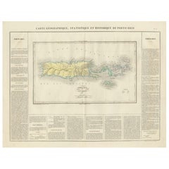
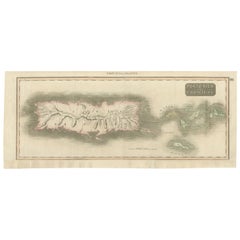
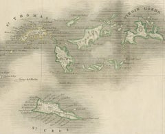
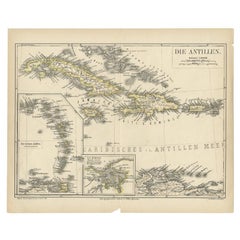
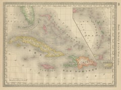
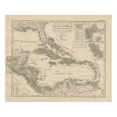
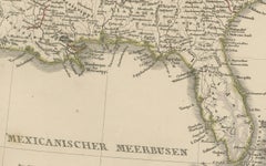
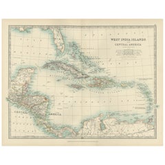
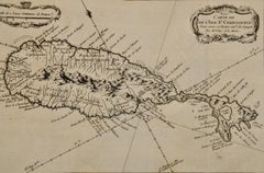
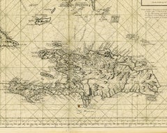
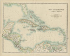
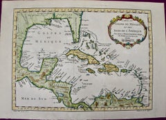
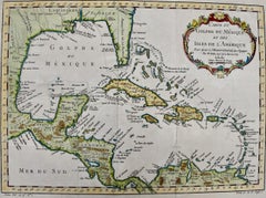
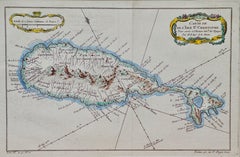
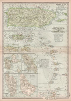
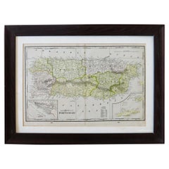
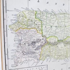
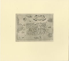
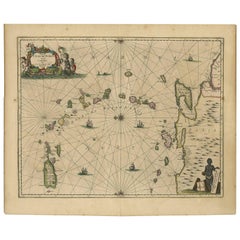
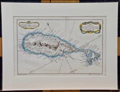
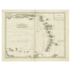
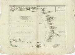
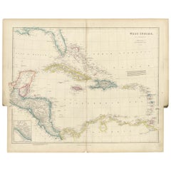
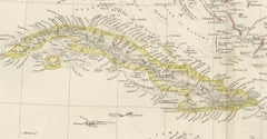
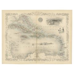
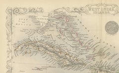
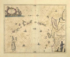
Antique Puerto Rico Map

Detailed Antique Map of Santa Domingo, Puerto Rico, Eastern Bahamas, ca. 1780
Located in Langweer, NL
Description: Antique map titled 'L'Isle De St. Domingue, et celle De Porto-Rico.' Detailed map
Category

1780s Antique Puerto Rico Map

Materials

Paper

1817 Map of Puerto Rico and the Virgin Islands with Original Hand Coloring
Located in Langweer, NL
The title provided for this map is "Porto Rico and Virgin Isles," and it is an antique map from an
Category

Early 19th Century Antique Puerto Rico Map

Materials

Paper

Puerto Rico 1910 Original Antique Map Of The Island In A Period Wood Frame
Located in Miami, FL
An antique framed map of Puerto Rico. Very nice antique map of Puerto Rico printed in a folio of
Category

Early 1900s Puerto Rican American Classical Antique Puerto Rico Map

Materials

Glass, Wood, Paper

Antique Map of the Antilles by Meyer, 1878
Located in Langweer, NL
Antique map titled 'Die Antillen'. Old map of the Antilles, it shows Jamaica, Puerto Rico, the
Category

19th Century Antique Puerto Rico Map

Materials

Paper

Original Antique Map of the West Indies by J. Arrowsmith, 1842
Located in Langweer, NL
Republic (eastern portion), is to the east of Cuba. 5. Jamaica is located south of Cuba. 6. Puerto Rico is
Category

Early 19th Century Antique Puerto Rico Map

Materials

Paper

1899 Poole Brothers Antique Railroad Map of the Illinois Central Railroad
Located in Colorado Springs, CO
inset map of Puerto Rico is included along the right border. An “Explanatory” text block is at left
Category

1890s American Antique Puerto Rico Map

Materials

Paper

St. Christophe 'St. Kitts' Island: An 18th Century Hand-colored Map by Bellin
By Jacques-Nicolas Bellin
Located in Alamo, CA
. It lies east of Puerto Rico, while Nevis is located to the south-east and the Dutch island of St
Category

Mid-18th Century French Antique Puerto Rico Map

Materials

Paper

Engraving by Tallis and Rapkin of Map of the West Indies in The Caribbean, 1851
Located in Langweer, NL
Cuba, Santo Domingo (Hispaniola / Hayti), Puerto Rico (Porto Rico), the Virgin Islands, Guadeloupe
Category

Mid-19th Century Antique Puerto Rico Map

Materials

Paper

Ornate Cartography of Colonial Grandeur: The West India Islands around 1851
Located in Langweer, NL
, Hispaniola (containing Haiti and the Dominican Republic), Puerto Rico, and various smaller islands of the
Category

1850s Antique Puerto Rico Map

Materials

Paper

S.Juan de Puerto Rico - Etching by Johannes Janssonius - 1650s
By Johannes Janssonius
Located in Roma, IT
S.Juan de Puerto Rico is an ancient map realized in 1650 by Johannes Janssonius (1588-1664). Good
Category

1650s Modern Antique Puerto Rico Map

Materials

Etching

St. Christophe (St. Kitts): Bellin 18th Century Hand Colored Map
Located in Alamo, CA
. It lies east of Puerto Rico, while Nevis is located to the south-east and the Dutch island of St
Category

1740s Other Art Style Antique Puerto Rico Map

Materials

Engraving

People Also Browsed

Augusto Marin exhibition poster (Puerto Rican artist)
By Rafael Tufino
Located in Wilton Manors, FL
Beautiful exhibition poster by Puerto rican artist, Rafael Tufino (1922-2008). Augusto Marin, Exposicion de Pinturas, 1965. Screen print on paper, 20 x 30 inches. Wear and creasing a...
Category

Mid-20th Century Abstract Expressionist Antique Puerto Rico Map

Materials

Screen

Antique American Empire Card/ Games Table in West Indies Mahogany with Pedestal
Located in Miami, FL
An American Empire games or card table with cylinder column resting on quatre-form base terminating with turned feet on casters. Swivel-top opens to a square with storage compartment...
Category

1830s American American Empire Antique Puerto Rico Map

Materials

Mahogany

Puerto Rico Institute of Culture poster (Puerto Rican artist)
By Lorenzo Homar
Located in Wilton Manors, FL
Rare promotional poster by Puerto Rican artist, Lorenzo Homar (1913-2004). Instituto de Cultura Puertorriquena San Juan, 1966. Sheet measures 18 x 24 inches. Screen print poster on ...
Category

Mid-20th Century Realist Antique Puerto Rico Map

Materials

Screen

Novena Theater Festival mid-century exhibition poster (Puerto Rican artist)
By Lorenzo Homar
Located in Wilton Manors, FL
Rare exhibition poster by Puerto Rican artist, Lorenzo Homar (1913-2004). Noveno Festival de Theatro Puertorriqueno, 1966. Screen print poster on paper. Wear and creasing as depicted...
Category

Mid-20th Century Abstract Antique Puerto Rico Map

Materials

Screen

Antique Map of Cuba, Haiti and Porto Rico by W. G. Blackie, 1859
Located in Langweer, NL
Antique map titled 'The Leeward or North Caribbean Islands'. Original antique map of Cuba, Haiti and Porto Rico. This map originates from ‘The Imperial Atlas of Modern Geography’. Pu...
Category

Mid-19th Century Antique Puerto Rico Map

Materials

Paper

Exhibition Poster Andy Warhol, Ladies and Gentlemen
By Andy Warhol
Located in Pasadena, CA
Ladies and Gentlemen Exhibition Poster (Portrait of Wilhelmina Ross) (1989) Andy Warhol Vintage 1989 Pop Art Lithograph Print Framed Paris Exhibition Poster " Ladies and Gentlemen ( ...
Category

Late 20th Century Pop Art Antique Puerto Rico Map

Materials

Lithograph, Offset, Screen

Eduardo Vera Cortes poster Antonio Maldonado exhibition (Puerto Rican artist)
Located in Wilton Manors, FL
Rare exhibition poster by Puerto Rican artist Carlos Osario. Una Gota de Sangre, 1963. Screen print on paper, 17.5 x 25 inches. Some wear and creasing in margins as depicted in deta...
Category

Mid-20th Century Abstract Antique Puerto Rico Map

Materials

Screen

Antonio Frasconi mid-century exhibition poster (Puerto Rican artist)
By Lorenzo Homar
Located in Wilton Manors, FL
Rare exhibition poster by Puerto Rican artist, Lorenzo Homar (1913-2004). Grabados de Antonio Frasconi, 1965. Screen print poster on paper. Minor wear and creasing as depicted in det...
Category

Mid-20th Century Abstract Antique Puerto Rico Map

Materials

Screen

Mid 19th C. Maritime Seascape Oil Painting on Canvas Manner of Adolphus Knell
By William Adolphus Knell 1
Located in Morristown, NJ
Manner of William Adolphus Knell (British 1805-1875). Framed maritime oil on canvas. Three-masted square rigger in background, with fishing vessels in foreground. No signature observ...
Category

Mid-19th Century English Greek Revival Antique Puerto Rico Map

Materials

Canvas, Wood, Paint

Original Engraving of the West Indies, Gulf of Mexico, Antilles, Caribbean, 1780
Located in Langweer, NL
Rigobert Bonne and G. Raynal's 1780 map of the West Indies, Gulf of Mexico, Antilles, and the Caribbean stands as a remarkable cartographic piece, offering a detailed and expansive v...
Category

Late 18th Century Antique Puerto Rico Map

Materials

Paper

Antique Merriman Nautical Maritime Sailboat Boat Ship Winch Copper Wood Handle
Located in Dayton, OH
Antique sailboat winch by Merriman Brothers. Made of copper with wooden handle. Marked with Merriman's trident logo. The MERRIMAN Bros. Inc. was founded in 1898, and published catal...
Category

Early 20th Century American Antique Puerto Rico Map

Materials

Copper

Original Antique Map of the Island of Dominica in the West Indies, 1794
Located in Langweer, NL
MAP OF THE ISLAND OF DOMINICA for the History of the West Indies, by Bryan Edwards. Esq. Dominica, an island renowned for its lucrative exports of sugar, cocoa, and coffee, operated...
Category

1790s Antique Puerto Rico Map

Materials

Paper

Authentique Map by Pilon of The French Colonies in The West Indies, 1876
Located in Langweer, NL
The 1876 map titled "Carte des Colonies Françaises aux Antilles" represents a significant contribution to cartography within the "Grand Atlas Départemental de la France de L'Algérie ...
Category

Late 19th Century Antique Puerto Rico Map

Materials

Paper

American Federal Drop Leaf Dining Table in West Indies Mahogany New York, c 1820
Located in Miami, FL
A handsome American Federal or Empire Pembroke table in fine West Indies mahogany with two drop leaves. This period breakfast table is supported by a reeded, vase-turned column on a ...
Category

Early 19th Century American Federal Antique Puerto Rico Map

Materials

Brass

Philadelphia Federal Wardrobe / Armoire in West Indies Mahogany c. !820
Located in Miami, FL
An exceptional American Federal wardrobe from Philadelphia in fine West Indies mahogany. Features split cylindrical columns with elaborate acanthus-carved Corinthian capitals flankin...
Category

Early 19th Century American Federal Antique Puerto Rico Map

Materials

Mahogany

70s Original cuban poster for the day of solidarity with Puerto Rico - OSPAAAL
Located in PARIS, FR
Despite its geographic isolation, the island of Cuba has produced more graphic material in support of oppressed peoples around the world than any other nation. This poster supports P...
Category

1970s Antique Puerto Rico Map

Materials

Paper, Lithograph

Recent Sales

Sea chart of Santa Domingo and its surroundings - Engraving - 18th century
Located in Zeeland, Noord-Brabant
eastern ends of Cuba and Jamaica, and the western end of Puerto Rico. Printed stipple rhumb lines are
Category

1750s Old Masters Antique Puerto Rico Map

Materials

Engraving

Bellin 18th Century Hand Colored Map of St. Christophe (St. Kitts)
By Jacques-Nicolas Bellin
Located in Alamo, CA
arc of the Windward Islands, in the Lesser Antilles. It lies east of Puerto Rico, while Nevis is
Category

Mid-18th Century French Antique Puerto Rico Map

Materials

Paper

Antique Map of the West India Islands and Central America by Johnston '1909'
Located in Langweer, NL
Antique map titled 'West India Islands and Central America'. Depicting Venezuela, Caribbean, Puerto
Category

Early 20th Century Antique Puerto Rico Map

Materials

Paper

Gulf of Mexico, Florida, C. America, Cuba: 18th C. Hand-colored Map by Bellin
By Jacques-Nicolas Bellin
Located in Alamo, CA
of Venezuela, and the islands of the Caribbean and West Indies. Cuba, Puerto Rico, Haiti, The
Category

1750s Antique Puerto Rico Map

Materials

Engraving

Early Map of Puerto Rico Printed in Venice by G. F. Camocio in 1571
Located in Langweer, NL
Porcacchi's map of the Island of Puerto Rico. One of the earliest obtainable maps of the Island and one of the
Category

16th Century Antique Puerto Rico Map

Materials

Paper

Antique Map of Cuba, Haïti, Jamaica, Puerto Rico and St Margareta, Havanna, 1630
Located in Langweer, NL
Title: "Cuba Insula" - "Hispaniola Insula". 2 old colors copper engraved maps of Cuba and Haïti
Category

1630s Antique Puerto Rico Map

Materials

Paper

Porto Rico (Puerto Rico) and The Lesser Antilles. Century Atlas antique map
Located in Melbourne, Victoria
'The Century Atlas. Porto Rico (Puerto Rico) and The Lesser Antilles.' Original antique map, 1903
Category

Early 20th Century Victorian Antique Puerto Rico Map

Materials

Lithograph

Antique Map of the Caribbean Islands by J. Jansson, circa 1650
By J. Jansson
Located in Langweer, NL
Beautiful hand-colored antique map which includes all the islands between Puerto Rico and Trinidad
Category

Mid-17th Century Antique Puerto Rico Map

Antique Map of the West India Islands and Central America by A.K. Johnston
Located in Langweer, NL
Antique map titled 'West India Islands and Central America'. Depicting Venezuela, Caribbean, Puerto
Category

Mid-19th Century Antique Puerto Rico Map

Gulf of Mexico, Florida, C. America, Cuba, etc.: 18th C. Hand-colored Bellin Map
By Jacques-Nicolas Bellin
Located in Alamo, CA
of Venezuela, and the islands of the Caribbean and West Indies. Cuba, Puerto Rico, Haiti, The
Category

Mid-18th Century French Antique Puerto Rico Map

Materials

Paper

Bellin 18th Century Hand Colored Map of St. Christophe (St. Kitts)
Located in Alamo, CA
arc of the Windward Islands, in the Lesser Antilles. It lies east of Puerto Rico, while Nevis is
Category

Late 18th Century Other Art Style Antique Puerto Rico Map

Materials

Engraving

J.H. Colton & Co. Hand Colored Engraved Map of Cuba, Jamaica, & Puerto Rico
By J.H. Colton
Located in Atlanta, GA
19th century circa 1850s hand colored engraved map of Cuba, Jamaica, and Puerto Rico, Published by
Category

19th Century American Antique Puerto Rico Map

Materials

Paper

Port Et Ville De Porto-Rico Dan's D'Isle de ce nom
Located in New York, NY
Beautiful hand colored map of the the Harbor of San Juan in Puerto Rico, depicting soundings
Category

1760s Realist Antique Puerto Rico Map

Materials

Engraving

Map of Neuve Castille
By Alain Manesson Mallet
Located in New York, NY
Published in 1685 this hand-colored map was created by Alain Manesson Mallet. Also shows Puerto
Category

18th Century and Earlier Realist Antique Puerto Rico Map

Materials

Engraving

Get Updated with New Arrivals
Save "Antique Puerto Rico Map", and we’ll notify you when there are new listings in this category.

Antique Puerto Rico Map For Sale on 1stDibs

Find many varieties of an authentic antique puerto rico map available at 1stDibs. An antique puerto rico map — often made from paper — can elevate any home. Your living room may not be complete without an antique puerto rico map — find older editions for sale from the 18th Century and newer versions made as recently as the 19th Century. Many designers have produced at least one well-made antique puerto rico map over the years, but those crafted by Jacques-Nicolas Bellin are often thought to be among the most beautiful.

How Much is a Antique Puerto Rico Map?

Prices for an antique puerto rico map can differ depending upon size, time period and other attributes — at 1stDibs, they begin at $94 and can go as high as $9,800, while the average can fetch as much as $575.