Items Similar to Authentique Map by Pilon of The French Colonies in The West Indies, 1876


Want more images or videos?
Request additional images or videos from the seller
1 of 6
Authentique Map by Pilon of The French Colonies in The West Indies, 1876
About the Item
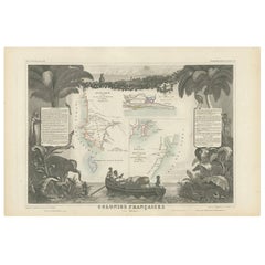
The 1876 map titled "Carte des Colonies Françaises aux Antilles" represents a significant contribution to cartography within the "Grand Atlas Départemental de la France de L'Algérie et des colonies" by H. Fisquet, published by A. Le Vasseur in Paris.
**Title:** Carte des Colonies Françaises aux Antilles
**Artist/Cartographer/Engraver:** Librairie Abel Pilon & Cie; A. Le Vasseur
**Provenance:** "Grand Atlas Départemental de la France de L'Algérie et des colonies" by H. Fisquet; Published by A. Le Vasseur, Paris [Grand atlas départemental]
**Type:** Antique engraved map with original hand coloring
This map is a significant representation of the French colonies in the West Indies during the late 19th century. Its inclusion in the larger "Grand Atlas Départemental" indicates its importance within a comprehensive collection of maps detailing the territories under French governance, including Algeria and the colonies.
Attributed to Librairie Abel Pilon & Cie and A. Le Vasseur, this antique engraved map features original hand coloring, highlighting geographical aspects and delineating between different territories, administrative boundaries, and natural features within the French Antilles.
Maps of this nature provide invaluable insights into the historical and geographical landscape of the French colonies in the West Indies during the 19th century. They serve as vital historical artifacts, offering a visual representation of political and geographical boundaries, cultural connections, and the colonial presence in the Caribbean during that period.
The French Colonies in the West Indies typically referred to several Caribbean islands and territories under French control during various periods of history. The main islands and regions that constituted the French West Indies included:
1. **Guadeloupe:** Comprising several islands, the main ones being Basse-Terre and Grande-Terre.
2. **Martinique:** A major island in the eastern Caribbean.
3. **Saint Martin:** The northern part of this island is under French control (the southern part, Sint Maarten, is Dutch).
4. **Saint Barthélemy:** Often referred to as St. Barts, a smaller island in the Caribbean.
5. **French Guiana:** Although located on the South American continent, it's considered part of the French West Indies due to its historical ties and its inclusion in the French Caribbean overseas departments.
6. **Saint Lucia:** Briefly held by the French at certain points in history, though it was predominantly British.
These territories, along with other smaller islands and dependencies, constituted the major French possessions in the West Indies. They were significant due to their economic contributions, primarily through sugarcane and other agricultural productions, as well as their strategic importance during periods of colonial competition between European powers in the Caribbean region.
VERSO: There is nothing printed on the reverse side, which is plain
AUTHENTICITY: This is an authentic historic print, published at the date stated above. I do not offer reproductions. It is not a modern copy. The term 'original' when applied to a print means that it was printed at the first or original date of publication; it does not imply that the item is unique. 'Print' means any image created by applying an inked block to paper or card under pressure by any method including wood engraving, steel engraving, copperplate, wood cut and lithography.
- Dimensions:Height: 14.38 in (36.5 cm)Width: 16.54 in (42 cm)Depth: 0 in (0.02 mm)
- Materials and Techniques:Paper,Engraved
- Period:
- Date of Manufacture:1876
- Condition:Good; suitable for framing. This map was coloured by hand at the time of publication. Strong paper but slightly soiled. Antiquarian maps and prints are subject to some normal aging due to use and time which is not obtrusive unless otherwise stated.
- Seller Location:Langweer, NL
- Reference Number:
About the Seller
5.0
Platinum Seller
These expertly vetted sellers are 1stDibs' most experienced sellers and are rated highest by our customers.
Established in 2009
1stDibs seller since 2017
1,919 sales on 1stDibs
Typical response time: <1 hour
- ShippingRetrieving quote...Ships From: Langweer, Netherlands
- Return PolicyA return for this item may be initiated within 14 days of delivery.
More From This SellerView All
- Antique Map of the West Indies by Wyld '1845'Located in Langweer, NLAntique map titled 'Map of the West India Islands'. Original antique map of the West Indies, including Cuba, the Bahamas, the Antilles a...Category
Antique Mid-19th Century Maps
MaterialsPaper
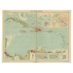
- Antique Map of the West Indies in Full Color, 1922Located in Langweer, NLAntique map titled 'The West Indies.' A map of the West Indies, the Carribean region. This includes the Greater Antilles (Jamaica, Haiti, Puerto Rico and Cuba) and the Lesser Antille...Category
20th Century Maps
MaterialsPaper
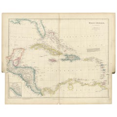
- Original Antique Map of the West Indies by J. Arrowsmith, 1842Located in Langweer, NLTitle: "J. Arrowsmith's 19th Century Map of the West Indies" This original antique map, crafted by J. Arrowsmith, details the West Indies with a focus on the Caribbean Sea and its s...Category
Antique Early 19th Century Maps
MaterialsPaper
- Antique Map of North America Including the West IndiesLocated in Langweer, NLOriginal antique map titled 'Nord-America'. Old map of North America and the West Indies. Also showing British Overseas Territories and Hudson Bay. This map originates from Stiel...Category
Antique Mid-19th Century Maps
MaterialsPaper
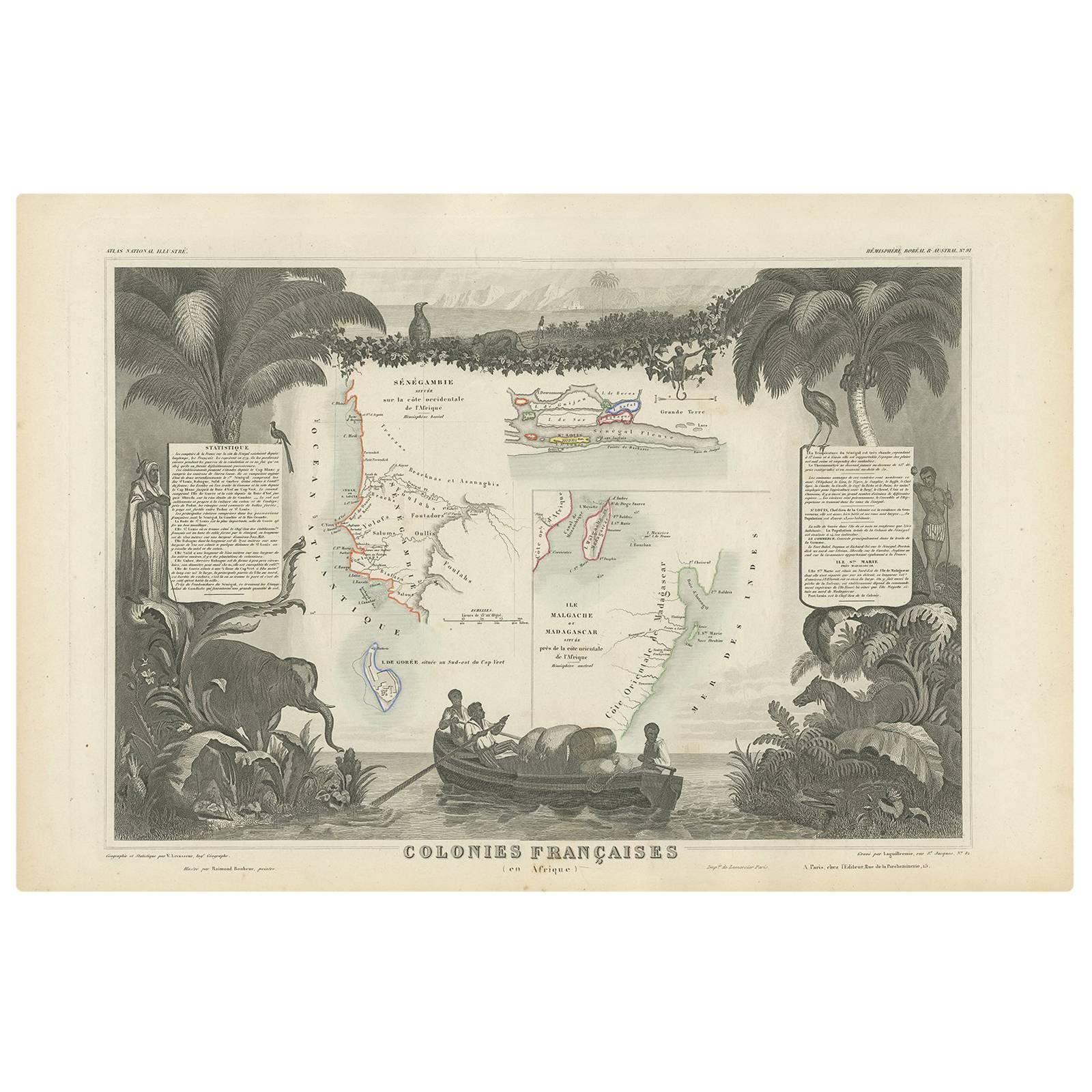
- Antique Map of the French Colonies in Senegal and Madagascar by V. LevasseurBy Victor LevasseurLocated in Langweer, NLThe antique map titled 'Colonies Françaises (en Afrique)' presents a decorative depiction of the French colonies located in Senegal and Madagascar within Africa. Surrounding the map ...Category
Antique Mid-19th Century Maps
MaterialsPaper
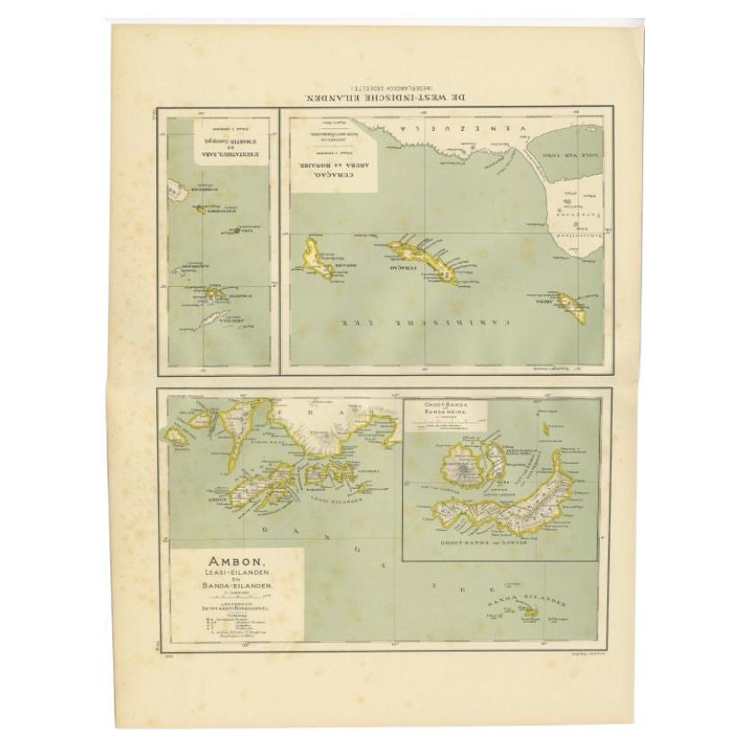
- Antique Map of the West Indies and Ambon in Indonesia, 1900Located in Langweer, NLTwo maps on one sheet titled 'De West-Indische Eilanden (Nederlandsch Gedeelte)' and 'Ambon, Leasi-Eilanden en Banda-Eilanden'. Old map of the Dutch West Indies and Ambon Island, Ind...Category
20th Century Maps
MaterialsPaper


You May Also Like
- Large Original Antique Map of The West Indies by Sidney Hall, 1847Located in St Annes, LancashireGreat map of The West Indies Drawn and engraved by Sidney Hall Steel engraving Original colour outline Published by A & C Black. 1847 Unframed Free shipping.Category
Antique 1840s Scottish Maps
MaterialsPaper
- Map Colonies Francaises Martinique, 1845Located in BUNGAY, SUFFOLKColonies Francaises, Martinique, Amerique DU SUD Geographie et Statistique par V.Levasseur. Ing'r Geographe. Illustre par Raymond Bonheur, peintre. Grave par Laguihermie, Rue St...Category
Antique 19th Century French Maps
MaterialsPaper
- Seminal guide to the East and West Indies, with 42 coloured maps and platesBy Jan Huygen van LinschotenLocated in ZWIJNDRECHT, NLSeminal guide to the East and West Indies, with 42 double-page and folding plates, including 6 maps, all engravings beautifully coloured by a contemporary hand LINSCHOTEN, Jan Huygh...Category
Antique Early 17th Century Dutch Dutch Colonial Books
MaterialsPaper
- Cricket Print, England v. West Indies at the Oval, by Arthur WeaverBy Arthur WeaverLocated in Oxfordshire, GB1990's Arthur Weaver Oval Cricket Ground Print, England v West Indies. A colourful cricket lithograph signed by the artist, Arthur Weaver, of the 'Final Test' at The Oval Cricket Gr...Category
1990s English Sporting Art Sports Equipment and Memorabilia
MaterialsPaper
- 17th Century Hand-Colored Map of a Region in West Germany by JanssoniusBy Johannes JanssoniusLocated in Alamo, CAThis attractive highly detailed 17th century original hand-colored map is entitled "Archiepiscopatus Maghdeburgensis et Anhaltinus Ducatus cum terris adjacentibus". It was published ...Category
Antique Mid-17th Century Dutch Maps
MaterialsPaper
- Germany West of the Rhine: A Hand-colored 18th Century Map by de WitBy Frederick de WitLocated in Alamo, CAThis original 18th century hand-colored map of the county of Moers, Germany entitled "Illustrissimo Celsissmo Principi GUILIELMO HENRICO D.G. Arausionum Principi Domino suo Clementis...Category
Antique Early 18th Century Dutch Maps
MaterialsPaper


Recently Viewed
View AllMore Ways To Browse
Antique Compass France
John Speed Isle Of Wight Maps
Compass France
Isle Of Wight Maps
Old French Map
Ancient Map Of Israel
John Tallis Map
Austria Hungary Map
Kiribati Islands Map
Map Of Kiribati Islands
Montana Maps
Oman Map
Palliser Furniture
Barbados Map
Map Of Barbados
Britton And Rey Lithograph
Christoph Weigel On Sale
Clivia Ducatus Et Ravestein Dominium