Items Similar to Antique Map of the West Indies and Ambon in Indonesia, 1900


Want more images or videos?
Request additional images or videos from the seller
1 of 6
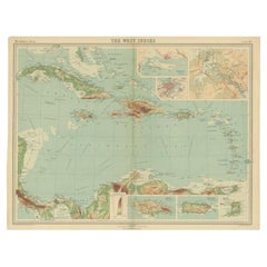
Antique Map of the West Indies and Ambon in Indonesia, 1900
About the Item
Two maps on one sheet titled 'De West-Indische Eilanden (Nederlandsch Gedeelte)' and 'Ambon, Leasi-Eilanden en Banda-Eilanden'. Old map of the Dutch West Indies and Ambon Island, Indonesia. This map originates from 'Atlas van Nederlandsch Oost- en West-Indië' by I. Dornseiffen.
Artists and Engravers: Published by Seyffardt's Boekhandel, Amsterdam.
Condition: Very good, general age-related toning. Please study image carefully.
Date: 1900
Overall size: 38.7 x 51.9 cm.
Image size: 33.6 x 42 cm.
We sell original antique maps to collectors, historians, educators and interior decorators all over the world. Our collection includes a wide range of authentic antique maps from the 16th to the 20th centuries. Buying and collecting antique maps is a tradition that goes back hundreds of years. Antique maps have proved a richly rewarding investment over the past decade, thanks to a growing appreciation of their unique historical appeal. Today the decorative qualities of antique maps are widely recognized by interior designers who appreciate their beauty and design flexibility. Depending on the individual map, presentation, and context, a rare or antique map can be modern, traditional, abstract, figurative, serious or whimsical. We offer a wide range of authentic antique maps for any budget.
- Dimensions:Height: 20.44 in (51.9 cm)Width: 15.24 in (38.7 cm)Depth: 0 in (0.01 mm)
- Materials and Techniques:
- Period:
- Date of Manufacture:1900
- Condition:Condition: Very good, general age-related toning. Please study image carefully.
- Seller Location:Langweer, NL
- Reference Number:
About the Seller
5.0
Platinum Seller
These expertly vetted sellers are 1stDibs' most experienced sellers and are rated highest by our customers.
Established in 2009
1stDibs seller since 2017
1,919 sales on 1stDibs
Typical response time: <1 hour
- ShippingRetrieving quote...Ships From: Langweer, Netherlands
- Return PolicyA return for this item may be initiated within 14 days of delivery.
More From This SellerView All
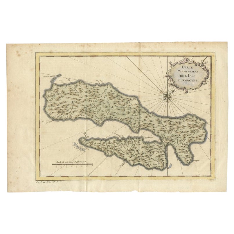
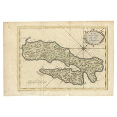
- Antique Map of Ambon Island in the Moluccas, Indonesia, c.1760Located in Langweer, NLAntique map Ambon titled 'Carte Particuliere de l 'Isle Amboine'. Old map showing Ambon, in the Moluccas Islands, better known as the Spice Islands. Ambon was the headquarters of the...Category
Antique 18th Century Maps
MaterialsPaper
- Antique Map of West Sumatra, Indonesia, 1900Located in Langweer, NLAntique map titled 'Sumatra, Bangka, Blitoeng en de Riouw-Archipel'. Old map of West Sumatra depicting the various islands and the Strait of Malacca. This map originates from 'Atlas ...Category
20th Century Maps
MaterialsPaper
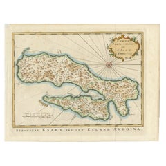
- Antique Map of Ambon Island, Indonesia, 1756Located in Langweer, NLAntique map titled ‘Carte particuliere de l'Isle d'Amboine - Byzondere kaart van het eyland Amboina’. Antique map of the island of Ambon, Indonesia. This map originates from 'Histori...Category
Antique 18th Century Maps
MaterialsPaper
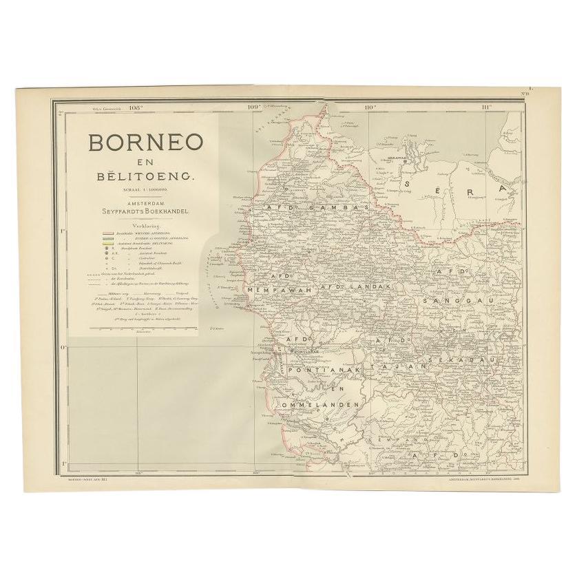
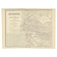
- Antique Map of West Kalimantan, Borneo, Indonesia, 1900Located in Langweer, NLAntique map titled 'Borneo en Belitoeng'. Old map of West Kalimantan, Borneo. This map originates from 'Atlas van Nederlandsch Oost- en West-Indië' by I. Dornseiffen. Artists and...Category
20th Century Maps
MaterialsPaper
- Antique Map of the West Indies in Full Color, 1922Located in Langweer, NLAntique map titled 'The West Indies.' A map of the West Indies, the Carribean region. This includes the Greater Antilles (Jamaica, Haiti, Puerto Rico and Cuba) and the Lesser Antille...Category
20th Century Maps
MaterialsPaper
- Antique Map of Central America and the West Indies, 1882Located in Langweer, NLAntique map titled 'West India Islands and Central America'. Old map of Central America and the West Indies. This map originates from 'The Royal Atlas of Modern Geography, Exhibiting...Category
Antique 19th Century Maps
MaterialsPaper


You May Also Like
- Large Original Antique Map of The West Indies by Sidney Hall, 1847Located in St Annes, LancashireGreat map of The West Indies Drawn and engraved by Sidney Hall Steel engraving Original colour outline Published by A & C Black. 1847 Unframed Free shipping.Category
Antique 1840s Scottish Maps
MaterialsPaper
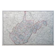
- Large Original Antique Map of West Virginia, USA, C.1900Located in St Annes, LancashireFabulous map of West Virginia Original color Engraved and printed by the George F. Cram Company, Indianapolis. Published, C.1900 Unframed Free shipping.Category
Antique 1890s American Maps
MaterialsPaper
- Seminal guide to the East and West Indies, with 42 coloured maps and platesBy Jan Huygen van LinschotenLocated in ZWIJNDRECHT, NLSeminal guide to the East and West Indies, with 42 double-page and folding plates, including 6 maps, all engravings beautifully coloured by a contemporary hand LINSCHOTEN, Jan Huygh...Category
Antique Early 17th Century Dutch Dutch Colonial Books
MaterialsPaper
- Original Antique Map of Indonesia, 1861Located in St Annes, LancashireGreat map of Indonesia Drawn and engraved by Edward Weller Original color Published in The Weekly Dispatch Atlas, 1861 Repairs to minor e...Category
Antique 1860s English Victorian Maps
MaterialsPaper

- Gold Leaf Foil Pictorial Plan Map of the West Country of England Antique StyleLocated in GBWe are delighted to offer for sale this lovely Antique style pictorial plan map of the West Country of England etched in gold leaf foil This is a very interesting and decorative p...Category
20th Century English Adam Style Maps
MaterialsGold Leaf
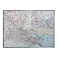
- Large Original Antique Map of Louisiana, USA, C.1900Located in St Annes, LancashireFabulous map of Louisiana. Original color. Engraved and printed by the George F. Cram Company, Indianapolis. Published, c.1900. Unframed. Repair ...Category
Antique 1890s American Maps
MaterialsPaper


Recently Viewed
View AllMore Ways To Browse
Vintage West Indies Map
Antique Map Livonia
Antique Maps Denver
Menorca Map
Sumba Map
Antique Cabbage Cutter
Wyld Globes
Antique Life Buoy
Antique Life Buoys
Atlantis Antique
Map Of Armenia
Gambia Antique Map
Victor Levasseur On Sale
Nova Totius
Antique Barbie Furniture
Antique Map Dordogne
Antique Yemen
Antique Map Montreal