Items Similar to Early Map of Puerto Rico Printed in Venice by G. F. Camocio in 1571

Want more images or videos?
Request additional images or videos from the seller
1 of 9
Early Map of Puerto Rico Printed in Venice by G. F. Camocio in 1571
About the Item
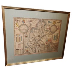
Title: S.Giovanni
Publication Info: Venice
Date: 1572
Place created: Venice
Marvelous example of Porcacchi's map of the Island of Puerto Rico. One of the earliest obtainable maps of the Island and one of the few published in the 16th Century. Excellent topographical detail, if a bit conjectural, and naming many locations. Includes decorative cartouche, 4 sea monsters and a compass rose. Also shows the Virgin Islands, with a large St. Croix (Croce) shown. An important early map for collectors of this Island.
Map shows America, Caribbean.
"Descrittione Del L'Isola Di S. Giouanni, detta Borichen". Copper etching from "L'Isole piu Famose del Mondo" (The most famous islands of the world by Thomas Porcacchi (1530 - 1585) and engraved by Girolamo Porro. The first edition of this work was published in Venice in 1572.
This is one of the oldes maps of Puerto Rico. Here it is named San Giouanni with the mention that the Indians called it Borichen. To the left is part of the Dominican Republic and in the lower right corner is part of St. Croix. The map is on a text page as shown with text on backside and a second page of text. The Italian text describes the early history and geography of Puerto Rico.
This captivating map of Puerto Rico, dating back to 1713, is rooted in the cartography of Giacomo Gastaldi. It provides a detailed depiction of the island, showcasing neighboring regions such as S. Croce (St. Croix), Le Vergini (Virgin Islands) to the east, and part of Hispaniola to the west.
Graphically engraved by Girolamo Porro, the map is adorned with intricate details, featuring a stipple-engraved sea embellished with an array of sea monsters, a compass rose, and an ornate title cartouche. San Giovanni (San Juan), originally christened by Christopher Columbus in honor of John the Baptist, is notably labeled on the map.
Originally appearing in Tomaso Porcacchi's renowned "L'Isole piu Famose del Mondo" (The Most Famous Islands of the World), this map made its debut in the 16th century and remained a significant inclusion in several editions between 1572 and 1686.
Later on, the plates from Porcacchi's work were utilized by Alphonsus Lasor a Varea for his publication "Universus Terrarum Orbis" in 1713. Lasor a Varea, also known as Raffaello Savonarola, compiled a comprehensive two-volume scriptural and historical dictionary, incorporating nearly 500 maps. These maps, sourced from plates by Valegio, Porcacchi, Rosaccio-Franco, and Magini, some over a century old, were frequently reworked and included in Lasor a Varea's work, providing a historical reference and geographical insight into regions such as Puerto Rico during that era.
- Dimensions:Height: 4.34 in (11 cm)Width: 5.91 in (15 cm)Depth: 0.01 in (0.2 mm)
- Materials and Techniques:Paper,Engraved
- Period:
- Date of Manufacture:1571
- Condition:good, given age. General age-related toning and/or occasional minor defects from handling. Comes with matting board. Please study scan carefully.
- Seller Location:Langweer, NL
- Reference Number:
About the Seller
5.0
Platinum Seller
These expertly vetted sellers are 1stDibs' most experienced sellers and are rated highest by our customers.
Established in 2009
1stDibs seller since 2017
1,922 sales on 1stDibs
Typical response time: <1 hour
- ShippingRetrieving quote...Ships From: Langweer, Netherlands
- Return PolicyA return for this item may be initiated within 14 days of delivery.
More From This SellerView All
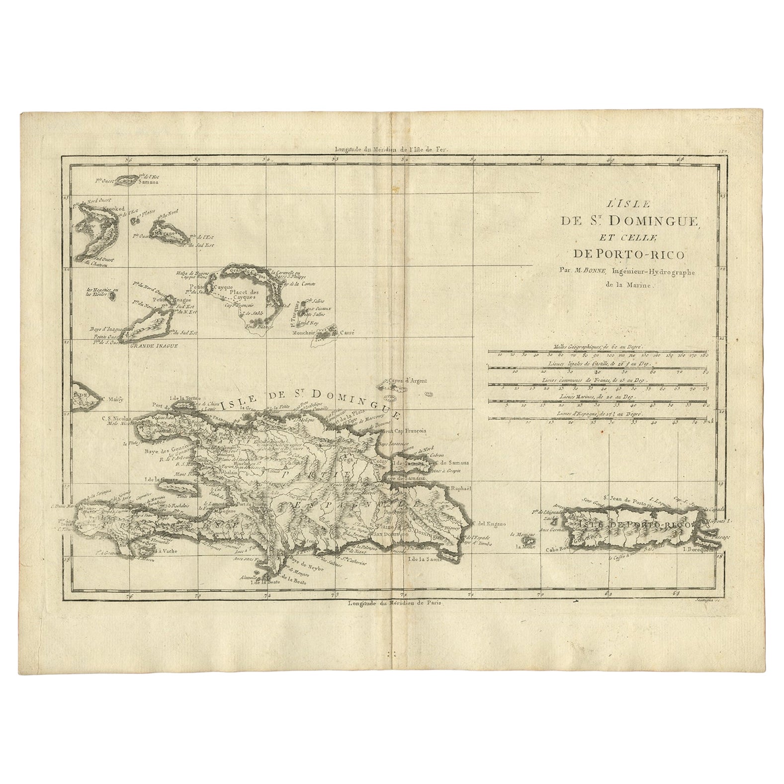
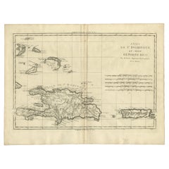
- Detailed Antique Map of Santa Domingo, Puerto Rico, Eastern Bahamas, ca. 1780Located in Langweer, NLDescription: Antique map titled 'L'Isle De St. Domingue, et celle De Porto-Rico.' Detailed map of Santa Domingo, Puerto Rico, etc. Includes substanti...Category
Antique 1780s Maps
MaterialsPaper
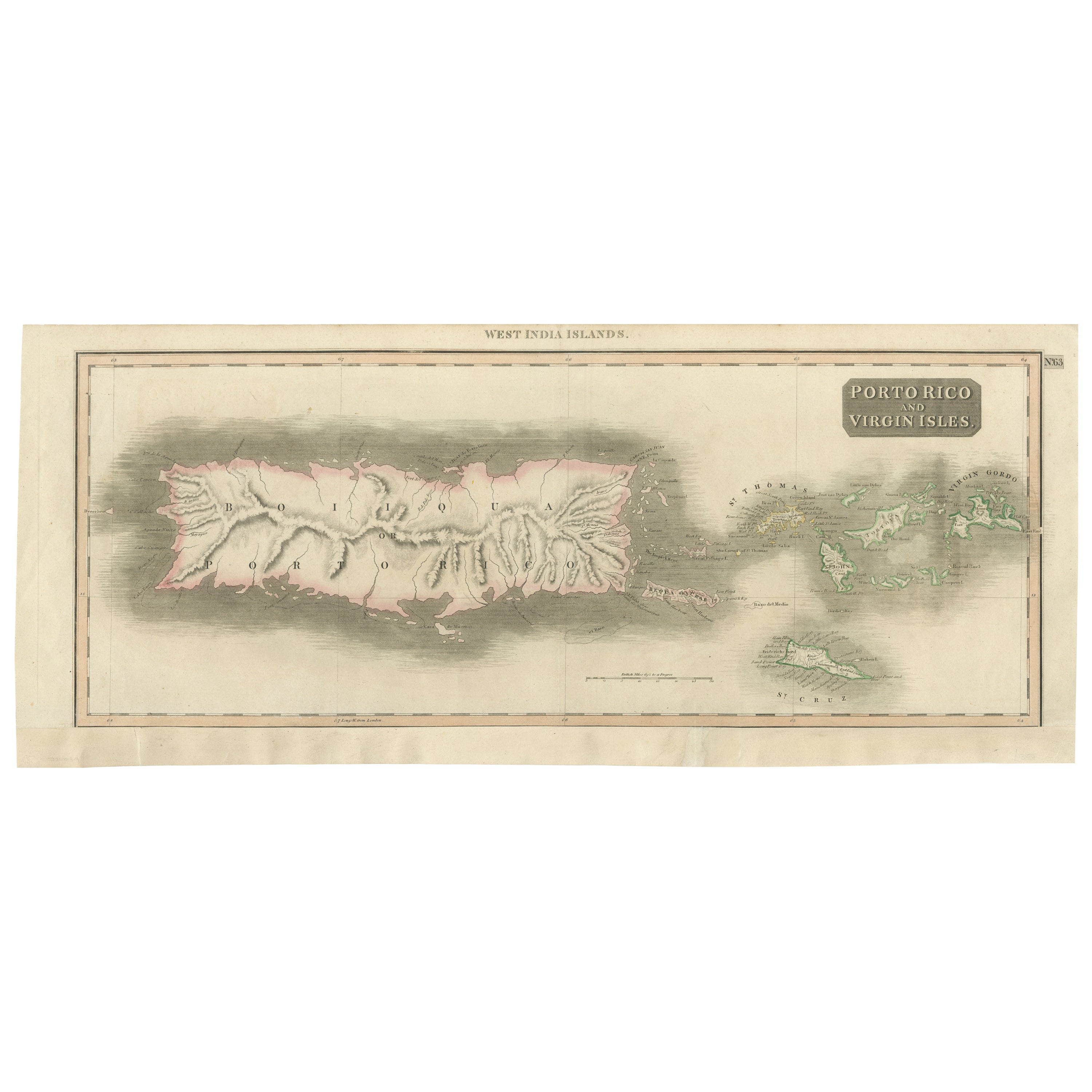
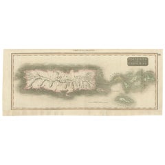
- 1817 Map of Puerto Rico and the Virgin Islands with Original Hand ColoringLocated in Langweer, NLThe title provided for this map is "Porto Rico and Virgin Isles," and it is an antique map from an early 19th century atlas, dated 1817, featuring original hand coloring. This histor...Category
Antique Early 19th Century Maps
MaterialsPaper
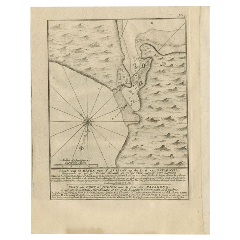
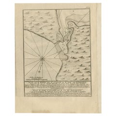
- Antique Map of Puerto San Julian in Patagonia, 1749Located in Langweer, NLAntique map titled 'Plan van de Haven van St. Juliaan op de Kust van Patagonia (..) - Plan du Port St. Julien, sur la Côte des Patagons (..)'. Original antique map of St. Julian on t...Category
Antique 18th Century Maps
MaterialsPaper
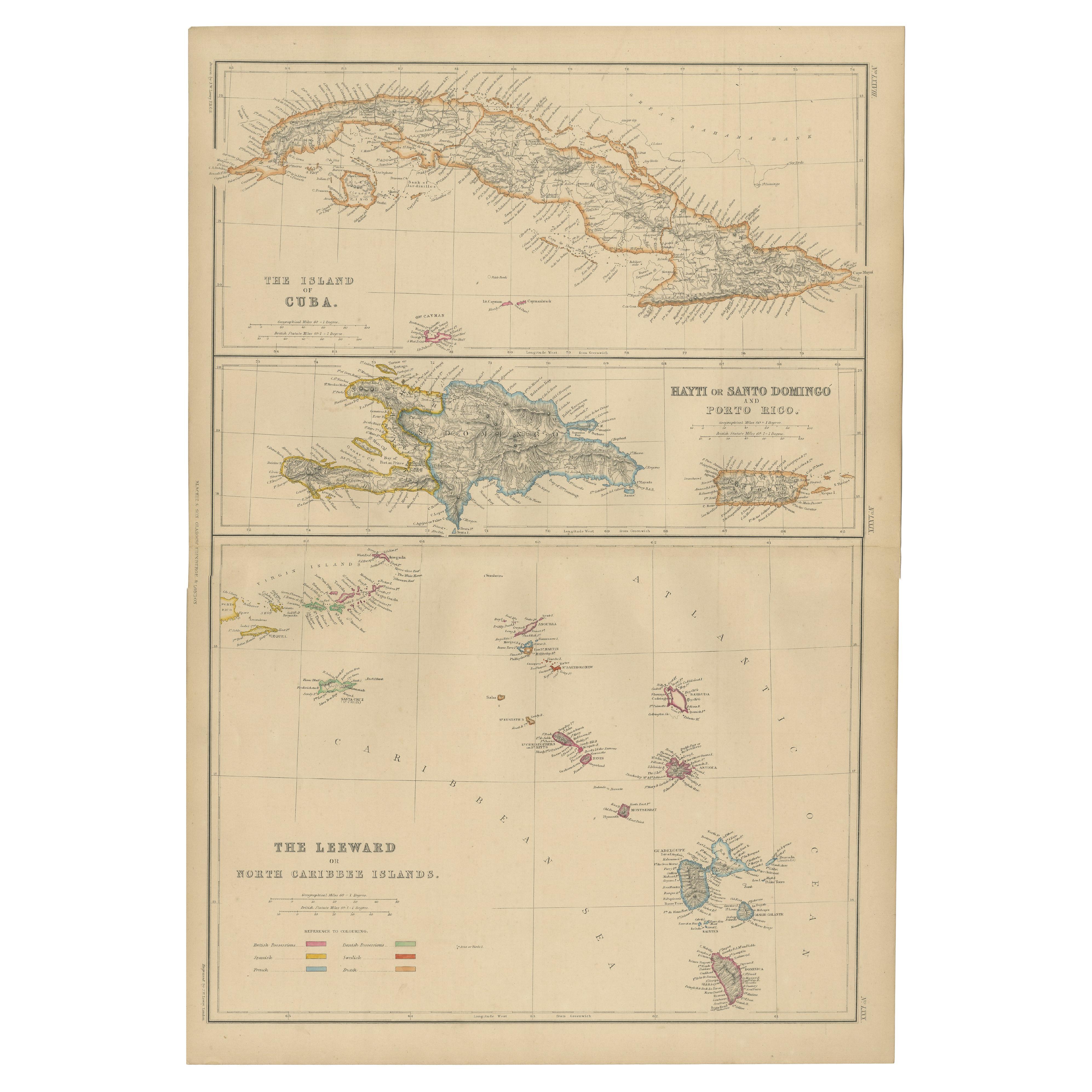
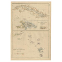
- Antique Map of Cuba, Haiti and Porto Rico by W. G. Blackie, 1859Located in Langweer, NLAntique map titled 'The Leeward or North Caribbean Islands'. Original antique map of Cuba, Haiti and Porto Rico. This map originates from ‘The Imperial Atla...Category
Antique Mid-19th Century Maps
MaterialsPaper
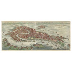
- Stunning Decorative Antique Map of Venice in Italy, ca.1787Located in Langweer, NLTitle: Piano elevato dell'inclita città di Venezia Bird's-eye view (etching) of Venice. Print made by: Marco Sebastiano Giampiccoli After: Matthäus Merian I Two copper engraved sh...Category
Antique Late 18th Century Maps
MaterialsPaper
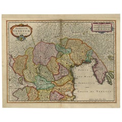
- Antique Map of the Area Around Venice in Italy by H. Hondius, circa 1606By Gerard Mercator, Jodocus HondiusLocated in Langweer, NLAttractive and early map of the area around Venice, Italy. With South-Tirol in the North, areas of Krain (Slovenia), Croatia, Ferrara, Modena and Piacenza. In the east with areas aro...Category
Antique Early 17th Century Maps
MaterialsPaper
You May Also Like
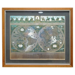
- World Map Silver Leaf Print Based on Original Willem Blaeu Wall Map 1571-1638Located in GBWe are delighted to offer for sale this lovely Antique style pictorial plan map of the globe based on the original Willem Blaeu 1571-1638 engraved in silver leaf foil This is a v...Category
20th Century English Campaign Maps
MaterialsSilver Leaf
- 1571-1638 Willem Blaeu map entitled, "Ilcadorino, " Hand Colored Ric0009Located in Norton, MAWillem Blaeu map entitled, "Ilcadorino,". Hand colored. Description: large, unusual, and nice antique copper engraved map of Ilcadorino, by Willem BL...Category
Antique 16th Century Dutch Maps
MaterialsPaper
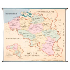
- XL Old School Map of Belgium 'Printed by Procure', 1950sLocated in Oostende, BEXL Old school map of Belgium (Printed by Procure). Presumably from around 1950-1960.Category
Vintage 1950s Belgian Mid-Century Modern Maps
MaterialsMetal
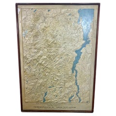
- Rare and Early Plaster Relief Map of Adirondack Mountains by F J H MerrillBy P.F. Howells, E. W. MerrillLocated in Buffalo, NYRare and Early Monumental Plaster Relief Map of Adirondack Mountains by The University of the State of New York, New York State Museum..F J H Merrill director,,,modeled by Howell's ...Category
Vintage 1910s American Industrial Maps
MaterialsPlaster, Wood
- 17th Century Map of Cumberland County in Northwest England Printed by John SpeedBy John SpeedLocated in Middleburg, VARare extremely early map of the county of Cumberland in the Northwest of England. Printed by John Speed, hand colored. Excellent condition. English. Dated...Category
Antique Early 17th Century English Maps
MaterialsPaper
- 1907 Map of Colorado, Antique Topographical Map, by Louis NellLocated in Colorado Springs, COThis highly detailed pocket map is a topographical map of the state of Colorado by Louis Nell from 1907. The map "has been complied from all availabl...Category
Antique Early 1900s American Maps
MaterialsPaper