Items Similar to Stunning Decorative Antique Map of Venice in Italy, ca.1787


Want more images or videos?
Request additional images or videos from the seller
1 of 7
Stunning Decorative Antique Map of Venice in Italy, ca.1787
About the Item
Title: Piano elevato dell'inclita città di Venezia
Bird's-eye view (etching) of Venice.
Print made by: Marco Sebastiano Giampiccoli
After: Matthäus Merian I
Two copper engraved sheets joined, later coloring, blank verso. First issued as a separate map circa 1630, according to Wüthrich, and in 1635 according to Moretto, Merian’s Venice had a long life; Giampiccoli’s version takes account of various revisions to the plate and no longer shows the Doge’s coat of arms: the Venetian Republic was conquered by Napoleon, and after a brief French occupation was ceded to Austria.
Engraving on copper, an interesting and uncommon bird's-eye view published by Giampiccoli, reusing the seventeenth-century plate by Merian, acquired by him; the print represents an important document of the city's development during the Napoleonic period. There are, of course, numerous modifications compared to the original German edition, and it was published in various states starting from around 1797 when Venice was still the "Capital of the Venetian Austrian provinces" (as stated in the title of the first state). Among the various states, there are numerous changes in place names, additions, and variations to the engraved part. Ours is a later one with the addition of the San Marco gardens, the two small towers in front of the island of San Giorgio, completed in 1813, and the public gardens in Castello.
A good example with some small stains and trace of the vertical fold. Some visible restorations on the back.
- Dimensions:Height: 12.6 in (32 cm)Width: 28.75 in (73 cm)Depth: 0 in (0.02 mm)
- Materials and Techniques:Paper,Engraved
- Period:
- Date of Manufacture:ca.1787
- Condition:Repaired: Some areas have been professionally restored. Good and decorative original antique print of Venice. Some small tears on the edges. One brown spot in the title. A crease near the small island top left and small loss in the sea top right. Nevertheless a very impressive print, ideal for framing.
- Seller Location:Langweer, NL
- Reference Number:
About the Seller
5.0
Platinum Seller
These expertly vetted sellers are 1stDibs' most experienced sellers and are rated highest by our customers.
Established in 2009
1stDibs seller since 2017
1,922 sales on 1stDibs
Typical response time: <1 hour
- ShippingRetrieving quote...Ships From: Langweer, Netherlands
- Return PolicyA return for this item may be initiated within 14 days of delivery.
More From This SellerView All
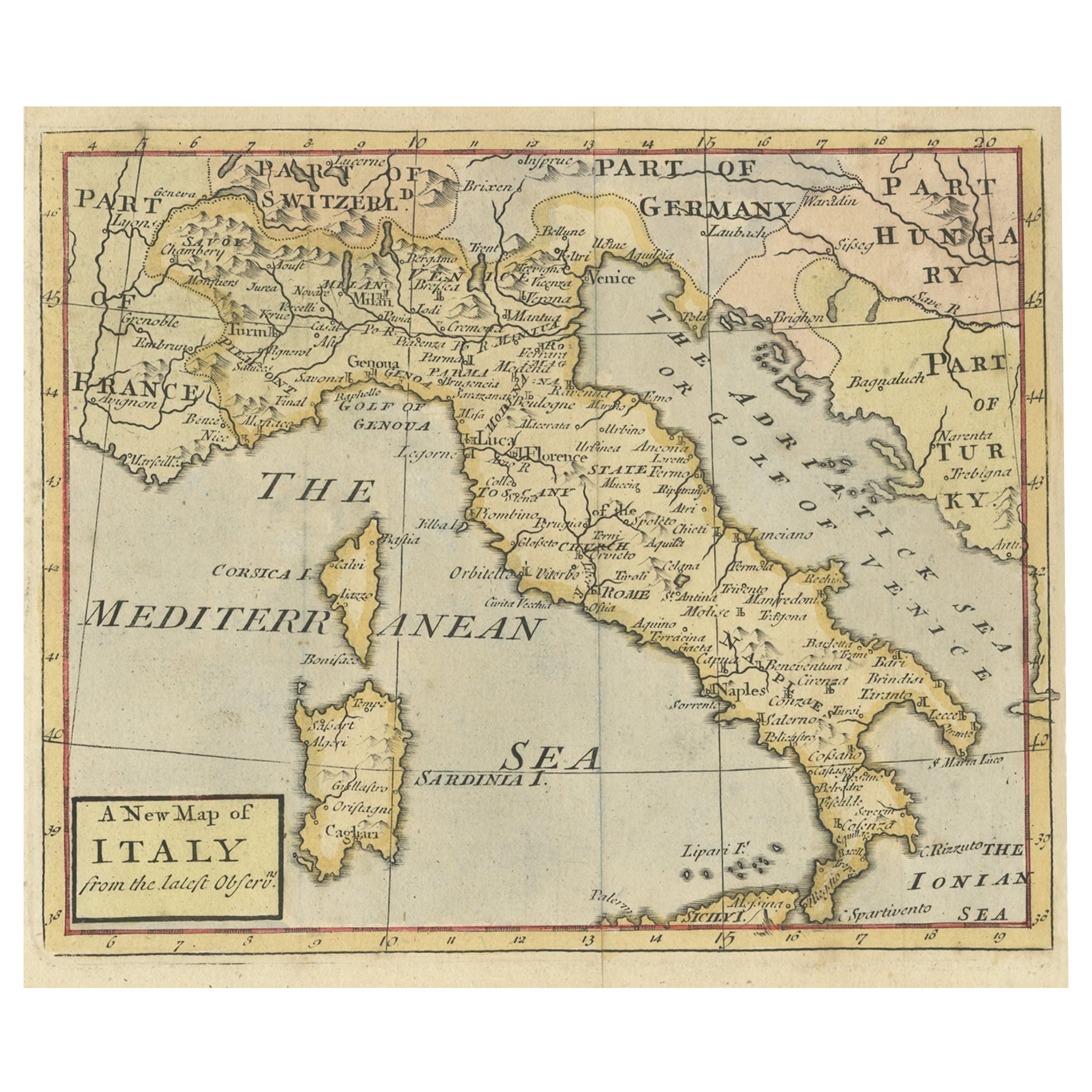
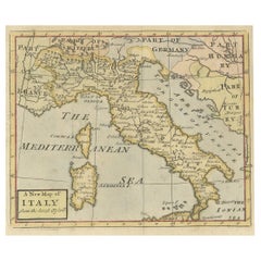
- Nice Decorative Hand-Colored Antique Map of Italy, ca.1745Located in Langweer, NLAntique map Italy titled 'A New Map of Italy from the lastest observations'. Antique map of Italy originating from 'Geography Anatomiz'd: or, The G...Category
Antique 1740s Maps
MaterialsPaper
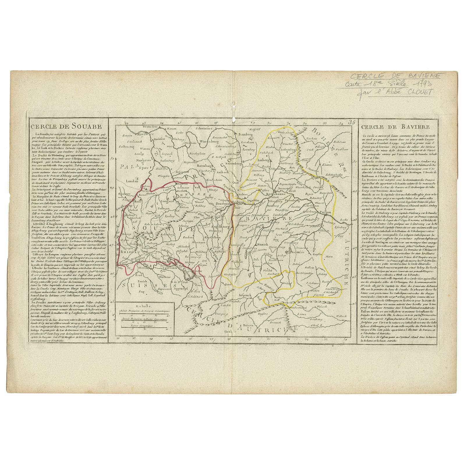
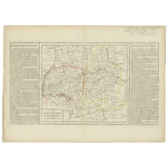
- Antique Map of Swabia by Clouet, '1787'Located in Langweer, NLAntique map titled 'Cercle de Souabe'. Antique map of Swabia, Germany. Originates from 'Geographie moderne avec une introduction' by J.B.L. Clouet.Category
Antique Late 18th Century Maps
MaterialsPaper
- Antique Map of Germany by Clouet, 1787Located in Langweer, NLAntique map titled 'L'Allemagne'. Antique map of Germany. Originates from 'Geographie moderne avec une introduction' by J.B.L. Clouet.Category
Antique Late 18th Century Maps
MaterialsPaper
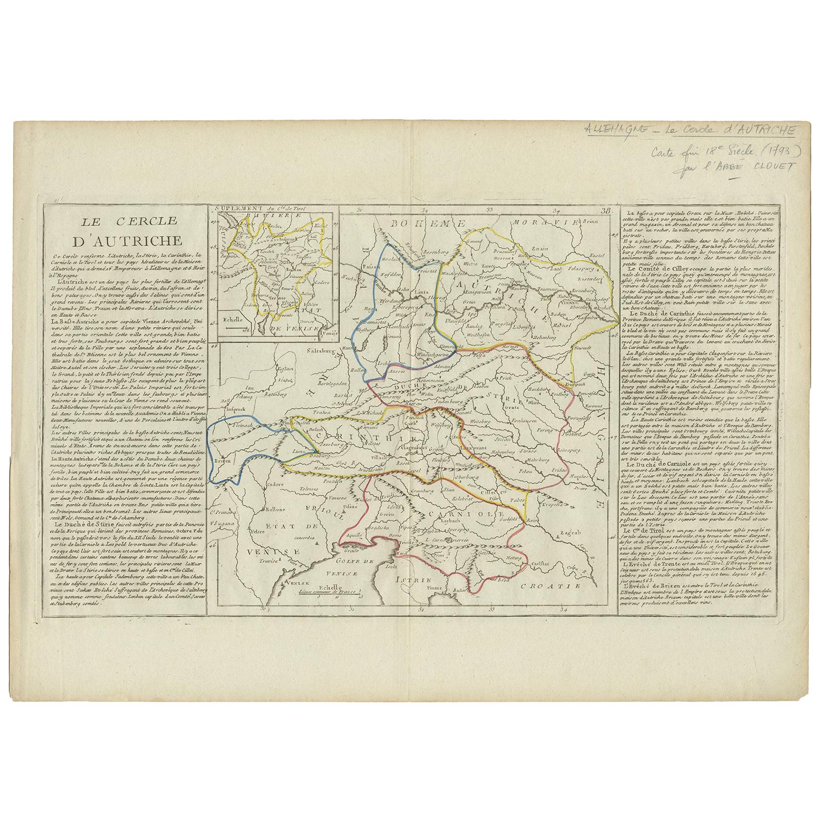
- Antique Map of Austria by Clouet '1787'Located in Langweer, NLAntique map titled 'Le Cercle d'Autriche'. Antique map of Austria. Originates from 'Geographie moderne avec une introduction' by J.B.L. Clouet.Category
Antique Late 18th Century Maps
MaterialsPaper
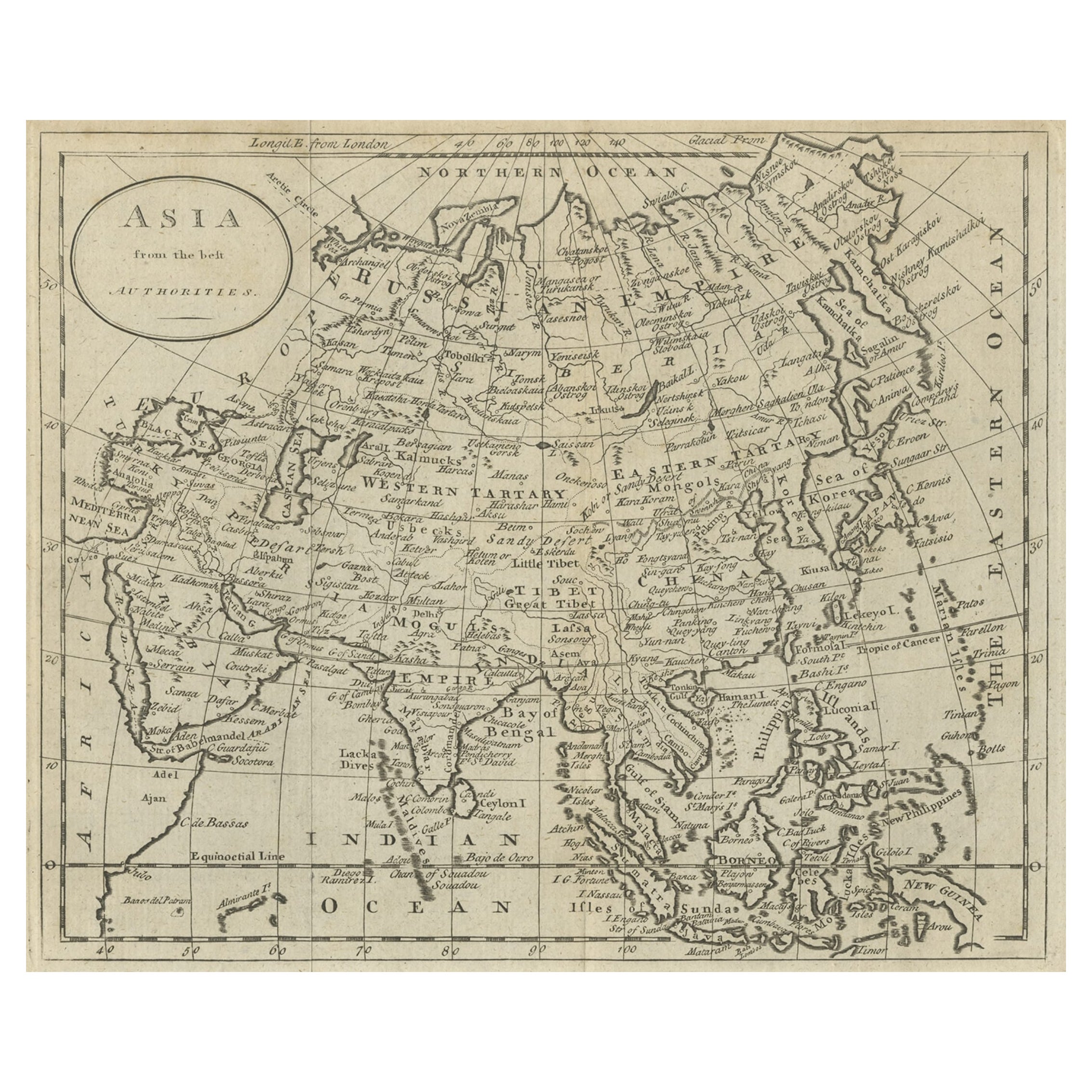
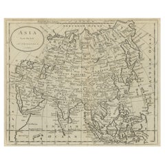
- Antique Map of Asia by Guthrie, 1787Located in Langweer, NLAntique map titled 'Asia from the best Authorities'. Old map of the Asian continent. This map originates from 'A New Geographical, Historical and Commercial Grammar; and Present State of the several Kingdoms of the World' 10th ed. by W. Guthrie. Artists and Engravers: Published by Ch.Dilly; GGJ...Category
Antique 18th Century Maps
MaterialsPaper
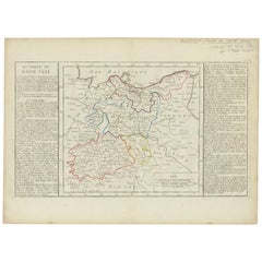
- Antique Map of Upper Saxony in Germany by Clouet, 1787Located in Langweer, NLAntique map titled 'Du Cercle de Haute Saxe'. Antique map of Upper Saxony, Germany. Originates from 'Geographie moderne avec une introduction' by J.B.L. Clouet.Category
Antique Late 18th Century Maps
MaterialsPaper


You May Also Like
- Original Antique Map of Ancient Greece- Boeotia, Thebes, 1787Located in St Annes, LancashireGreat map of Ancient Greece. Showing the region of Boeotia, including Thebes Drawn by J.D. Barbie Du Bocage Copper plate engraving by P.F T...Category
Antique 1780s French Other Maps
MaterialsPaper
- Original Antique Map of Ancient Greece, Phocis, Gulf of Corinth, 1787Located in St Annes, LancashireGreat map of Ancient Greece. Showing the region of Phocis, including the Gulf of Corinth Drawn by J.D. Barbie Du Bocage Copper plate engraving by P.F Tardieu Original hand c...Category
Antique 1780s French Other Maps
MaterialsPaper
- Antique Hand-Coloured Map of Venice with Vintage Frame, Italy, Late 18th CenturyLocated in Copenhagen K, DKItaly, late 18th Century Antique hand-coloured map of Venice. Measures: H 52 x W 59 cm.Category
Antique Late 18th Century Italian Decorative Art
MaterialsOther
- Original Antique Map of Italy. C.1780Located in St Annes, LancashireGreat map of Italy Copper-plate engraving Published C.1780 Unframed.Category
Antique Early 1800s English Georgian Maps
MaterialsPaper

- Original Antique Decorative Map of Iceland & Faroe, Fullarton, C.1870Located in St Annes, LancashireGreat map of Iceland and The Faroe Islands Wonderful figural border From the celebrated Royal Illustrated Atlas Lithograph. Original color. Published by Fullarton, Edinb...Category
Antique 1870s Scottish Maps
MaterialsPaper
- Original Antique Map of Italy. Arrowsmith. 1820Located in St Annes, LancashireGreat map of Italy Drawn under the direction of Arrowsmith Copper-plate engraving Published by Longman, Hurst, Rees, Orme and Brown, 1820 Unframed.Category
Antique 1820s English Maps
MaterialsPaper


Recently Viewed
View AllMore Ways To Browse
Map Of Ceylon
Old French Map
John Tallis Map
Australia Captain Cook
Map Zanzibar
Topographical Globe
Dan Rizzi
Formosa Vintage Map
Vincenzo Coronelli On Sale
Willem Blaeu On Sale
Antique Map Of Republic Of Texas
Antique Maps Denver
Cartier 1730
Collectible Barbies
Devonia Antique
J Karte
Map Cleveland
Union Pacific Map