Items Similar to Roseaux, St. Lucia Island Map by BELLIN, Handcolored Engraving, 1763


Want more images or videos?
Request additional images or videos from the seller
1 of 6
Roseaux, St. Lucia Island Map by BELLIN, Handcolored Engraving, 1763
About the Item
Dating back to around 1763, this antique hand-colored print, a creation by Jacques Nicolas Bellin, unveils a meticulously detailed "Plan du Cul de Sac des Roseaux dans l'Isle de Ste. Lucie." Crafted as part of Bellin's renowned "Petit atlas maritime," this map showcases an exquisite depiction of the natural harbor at Roseaux, situated within the captivating landscape of St. Lucia in the West Indies.
This piece is a testament to Bellin's cartographic expertise and meticulous attention to detail. The hand-colored touch brings vibrancy to the map, highlighting key geographical features and coastal intricacies. Its inclusion in the "Maps West Indies St. Lucia" category underscores its significance in understanding the cartographic landscape of the region during that era.
Considered in very good condition with minor imperfections, this print stands as a valuable collectible, offering a glimpse into the historical mapping endeavors of Bellin. With its precise cartographic representation and meticulous coloring, this artifact preserves a moment in time, inviting viewers to explore and appreciate the maritime cartography of the West Indies, specifically the enchanting allure of St. Lucia's Cul de Sac des Roseaux.
- Dimensions:Height: 12.6 in (32 cm)Width: 9.26 in (23.5 cm)Depth: 0 in (0.02 mm)
- Materials and Techniques:Paper,Engraved
- Period:1760-1769
- Date of Manufacture:1763
- Condition:Very good condition with minor brown spots mostly outside the image. Study the image carefully.
- Seller Location:Langweer, NL
- Reference Number:
About the Seller
5.0
Platinum Seller
These expertly vetted sellers are 1stDibs' most experienced sellers and are rated highest by our customers.
Established in 2009
1stDibs seller since 2017
1,919 sales on 1stDibs
Typical response time: <1 hour
- ShippingRetrieving quote...Ships From: Langweer, Netherlands
- Return PolicyA return for this item may be initiated within 14 days of delivery.
More From This SellerView All
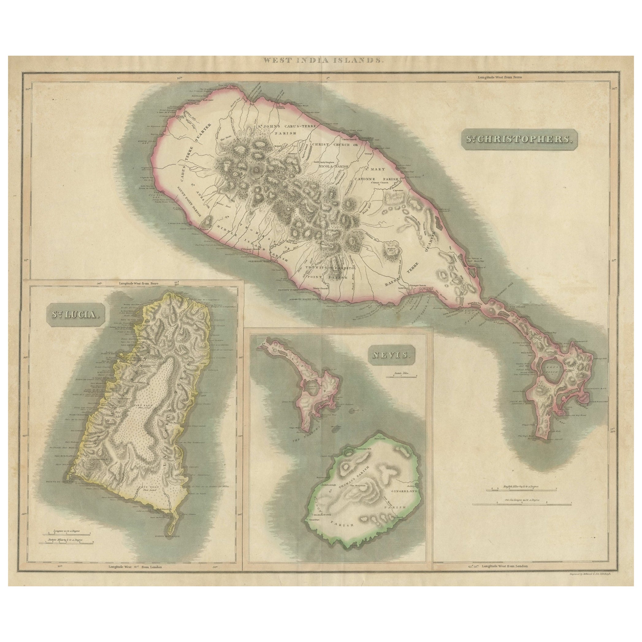
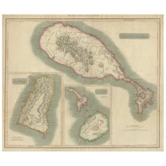
- 1817 John Thomson's Handcolored Antique Map of St. Kitts, Nevis, and St. LuciaLocated in Langweer, NLThis is an antique map depicting the islands of St. Kitts (St. Christopher's) and Nevis in the West Indies, along with a smaller inset map of St. Lucia. The main map focuses on St. Kitts, with detailed topographical features such as mountain ranges, volcanic peaks, and plantation areas indicated by cross-hatching and stippling. The coastline is meticulously outlined, with bays and capes labeled. The island of Nevis appears in a smaller inset on the right, detailed in a similar fashion with its own unique landscape features. The inset of St. Lucia at the bottom left shows the rugged terrain of the island, including its mountains and natural harbors. Each island's map is framed within its own neat line border, with a title block for identification. The map appears to be hand-colored, a common practice of the time for high-quality maps, which emphasizes the land against the sea. Pink shading outlines the islands, while green tones likely represent lower elevations and yellow tones for higher elevations. The condition of the map suggests it has been well-preserved, with the paper maintaining its integrity and the colors remaining vivid. There are signs of aging, such as slight discoloration and possible foxing, but these are typical for documents of this era and do not significantly detract from the visual appeal or the information presented. This map would have been an important navigational aid for sailors and a source of geographic knowledge for those interested in the West Indies during the period it was made. The craftsmanship and detail also make it a fine example of cartographic art...Category
Antique Early 19th Century Maps
MaterialsPaper
- Antique Map of the Maluku Islands by Bellin, c.1750By Jacques-Nicolas BellinLocated in Langweer, NLAntique map titled 'Carte Particuliere des Isles Moluques'. This map depicts the islands of Herij, Ternate, Tidor, Pottebackers, Timor, Machian and Bachian. The Moluccan islands were...Category
Antique 18th Century Maps
MaterialsPaper
- Antique Map of Gorée Island ‘Senegal’ by J.N. Bellin, 1764Located in Langweer, NLNautical antique chart of Gorée Senegal including a letter key to the island's fortifications. Gorée is known as the location of the House of Slaves built by an Afro-French Métis fam...Category
Antique Mid-18th Century Maps
MaterialsPaper
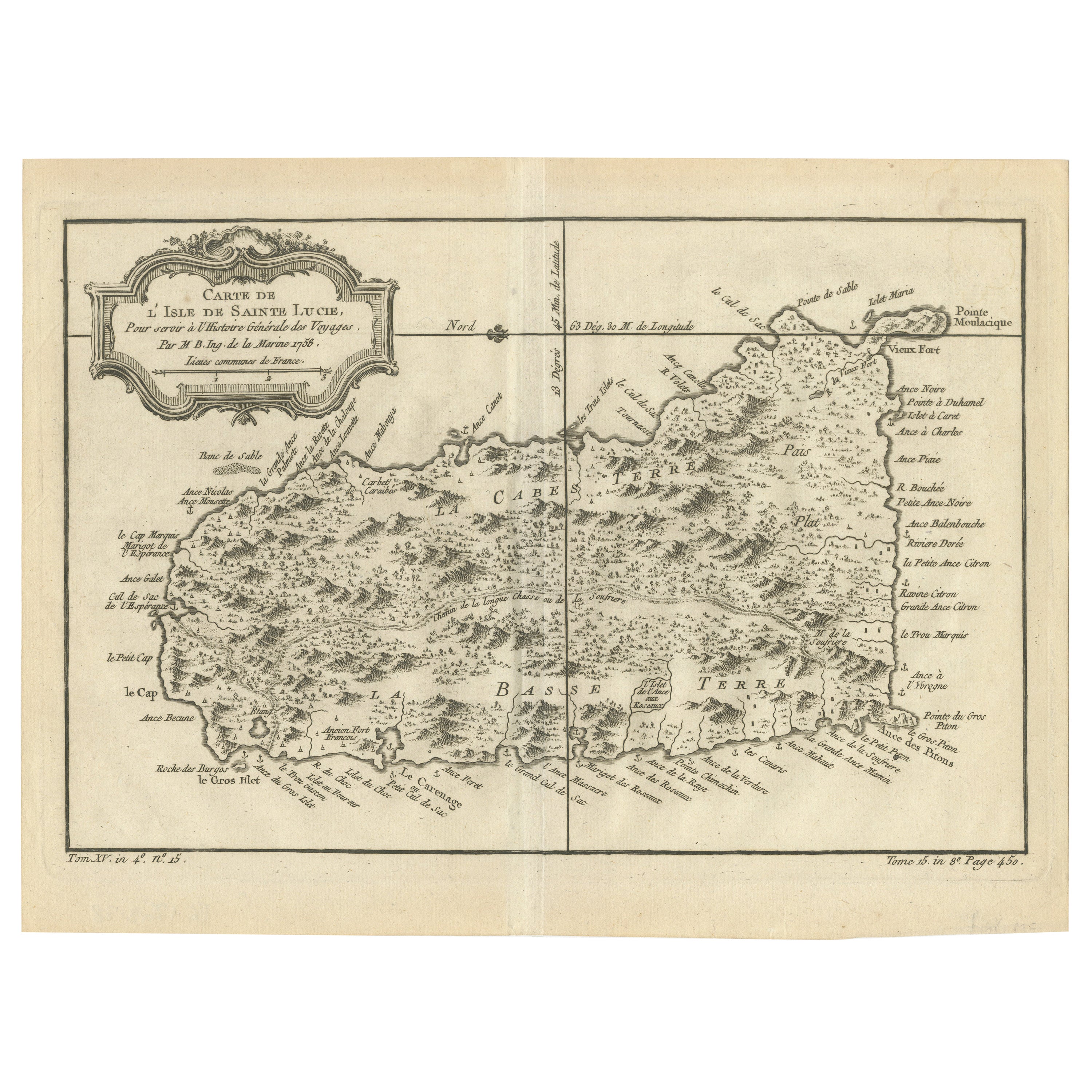
- Original Engraved Map of Saint Lucia in the West Indies by Bellin, 1758Located in Langweer, NLThe "Carte de L’Isle de Sainte Lucie" by Jacques Nicolas Bellin, a prominent figure as the Royal Hydrographer and engineer of the French Navy, is a remarkable antique map showcasing ...Category
Antique 1750s Maps
MaterialsPaper
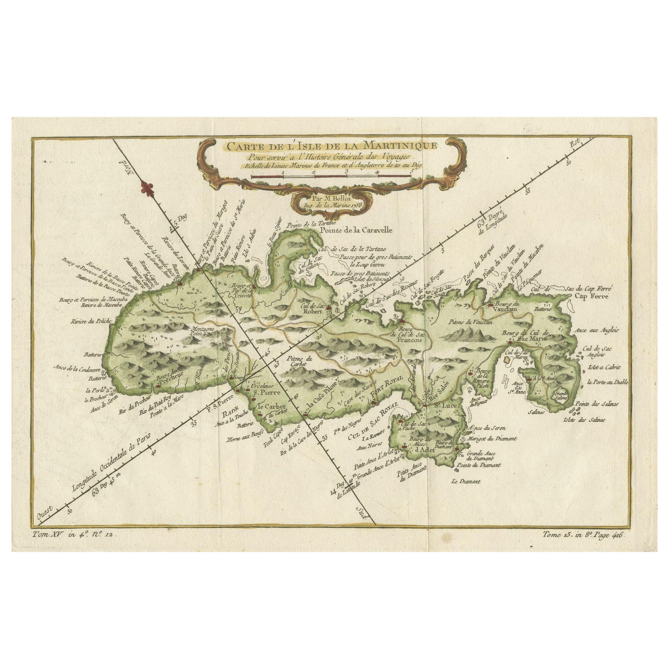
- Martinique Island in the Caribbean by Bellin Original Original Antique Map, 1780Located in Langweer, NLThis mid-18th century map, "Carte de l'Isle de la Martinique pour servir a l'historie generale des voyages," was issued in 1780 by M. Bellin in Paris. It presents a detailed and visually captivating depiction of the Island of Martinique within the context of the Caribbean and the Lesser Antilles. **Title:** Carte de l'Isle de la Martinique pour servir a l'historie generale des voyages **Issuer:** M. Bellin **Date:** 1780 **Location Coverage:** North America, Caribbean, Martinique, Lesser Antilles This engraved map is notable for its pleasing aesthetics, featuring lovely hand coloring that enhances its visual appeal. The inclusion of a scroll cartouche, an ornamental frame, and measurement lines adds a distinctive and visually appealing quality to the map. Martinique, situated within the Lesser Antilles in the Caribbean, is presented with meticulous detail, showcasing geographical features, coastlines, settlements, and other notable landmarks. Bellin, known for his accuracy in cartography, crafted this map to serve as a geographical reference within the broader context of historical voyages and exploration. The combination of detailed cartographic information and artistic embellishments, such as hand coloring and decorative elements, makes this map not only a valuable geographical document but also a visually pleasing piece of cartographic art...Category
Antique Late 18th Century Maps
MaterialsPaper
- Engraved Map by Bellin of Saint Lucia or Sainte Lucie in the West Indies, 1764Located in Langweer, NLThe "Carte de L’Isle de Sainte Lucie" by Jacques Nicolas Bellin, a prominent figure as the Royal Hydrographer and engineer of the French Navy, is a remarkable antique map showcasing ...Category
Antique Late 19th Century Maps
MaterialsPaper


You May Also Like
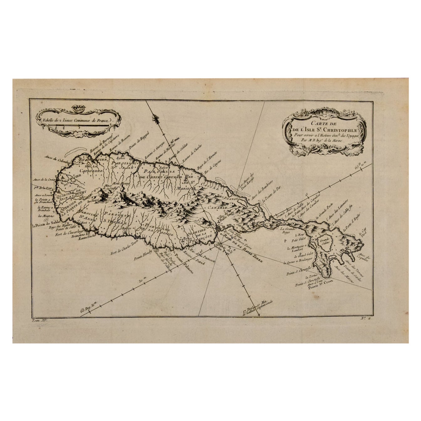
- St. Christophe 'St. Kitts' Island: An 18th Century Hand-colored Map by BellinBy Jacques-Nicolas BellinLocated in Alamo, CAJacques Bellin's copper-plate map of the Caribbean island of Saint Kitts entitled "Carte De De l'Isle St. Christophe Pour servir á l'Histoire Genle. des V...Category
Antique Mid-18th Century French Maps
MaterialsPaper
- Captain Cook's Exploration of Tahiti 18th C. Hand-Colored Map by BellinBy Jacques-Nicolas BellinLocated in Alamo, CAThis beautiful 18th century hand-colored copper plate engraved map is entitled "Carte de l'Isle de Taiti, par le Lieutenant J. Cook" was created by Jacques Nicolas Bellin and publish...Category
Antique Mid-18th Century French Maps
MaterialsPaper
- New Map of North America from the Latest Discoveries, 1763Located in Philadelphia, PAA fine antique 18th century map of the North American seaboard. Entitled "A New Map of North America from the Latest Discoveries 1763". By the Cartographer/Engraver - John Spil...Category
Antique Mid-18th Century English Georgian Maps
MaterialsPaper
- West Coast of Africa, Guinea & Sierra Leone: An 18th Century Map by BellinBy Jacques-Nicolas BellinLocated in Alamo, CAJacques Bellin's copper-plate map entitled "Partie de la Coste de Guinee Dupuis la Riviere de Sierra Leona Jusquau Cap das Palmas", depicting the coast of Guinea and Sierra Leone in ...Category
Antique Mid-18th Century French Maps
MaterialsPaper
- Map Jersey Guernsey Scilly Islands AlderneyLocated in BUNGAY, SUFFOLKRare map of The Islands of Guernsey and Jersey, including Alderney & the Scilly Islands just purchased more information to follow In the original cream mount and gilded frame.Category
Antique 18th Century English Georgian Maps
MaterialsPaper
- 1854 Map of Massachusetts, Connecticut and Rhode Island, Antique Wall MapLocated in Colorado Springs, COThis striking wall map was published in 1854 by Ensign, Bridgman & Fanning and has both full original hand-coloring and original hardware. This impression is both informative and highly decorative. The states are divided into counties, outlined in red, green, and black, and subdivided into towns. Roads, canals, and railroad lines are prominently depicted, although they are not all labeled. The mapmakers also marked lighthouses, banks, churches, and prominent buildings, with a key at right. The map is an informative and comprehensive overview of the infrastructural development of New England prior to the Civil War. Physical geographies depicted include elevation, conveyed with hachure marks, rivers and lakes. The impression features an inset map of Boston...Category
Antique 19th Century American Maps
MaterialsPaper


Recently Viewed
View AllMore Ways To Browse
Ree Brown
Winkler Prins
Very Large Map
Antique American Victorian Furniture
A Plan City And Castle Of Batavia
Cheshire Map
John Speed Isle Of Wight Maps
Malacca Strait Map
Antique Map Of South Korea
Map Of Maine Et Loire
Mapp Plate
Marthas Vineyard Map
Nantucket Chart
Native American Mountie
Nicolaes Visscher II On Sale
Vintage Marthas Vineyard Map
W. & A.K. Johnston On Sale
Yemen 1789