Items Similar to Map Jersey Guernsey Scilly Islands Alderney


Want more images or videos?
Request additional images or videos from the seller
1 of 6
Map Jersey Guernsey Scilly Islands Alderney
About the Item
Rare map of The Islands of Guernsey and Jersey, including Alderney & the Scilly Islands
just purchased more information to follow
In the original cream mount and gilded frame.
- Dimensions:Height: 12.21 in (31 cm)Width: 14.18 in (36 cm)Depth: 0.79 in (2 cm)
- Style:Georgian (Of the Period)
- Materials and Techniques:
- Place of Origin:
- Period:
- Date of Manufacture:circa 1720
- Condition:Wear consistent with age and use.
- Seller Location:BUNGAY, GB
- Reference Number:1stDibs: LU3867332633832
About the Seller
5.0
Vetted Seller
These experienced sellers undergo a comprehensive evaluation by our team of in-house experts.
Established in 1985
1stDibs seller since 2018
84 sales on 1stDibs
Typical response time: 9 hours
- ShippingRetrieving quote...Ships From: BUNGAY, United Kingdom
- Return PolicyA return for this item may be initiated within 7 days of delivery.
More From This SellerView All
- Map Bedfordshire General FramedLocated in BUNGAY, SUFFOLKA general map of Bedfordshire with its hundreds A scale of 5 miles in the original green mount and traditional black and gold frame. Measures: 36cm 14" high.Category
Antique 18th Century English Georgian Maps
MaterialsPaper
- Map Bedfordshire No 3 General FramedLocated in BUNGAY, SUFFOLKA general map of Bedfordshire with its hundreds. Measure: 37cm 14 1/2" high A scale of 5 miles. in the original green mount and traditional black and gold frame. charming map with...Category
Antique 18th Century English Georgian Maps
MaterialsPaper
- Map North Wales Robert Marsden AngleseyLocated in BUNGAY, SUFFOLKMap of North Wales by Robert Marsden Including Anglesey Charming topography and detail and colouring just purchased more information to follow.Category
Antique 18th Century English Georgian Maps
MaterialsPaper
- Map SussexLocated in BUNGAY, SUFFOLKMap of Sussex with explanation Maker unknown.Category
Antique 19th Century English Victorian Maps
MaterialsPaper
- Map Kyle Carrick Aireshire Thomas Kitchen 1749By Thomas KitchinLocated in BUNGAY, SUFFOLKA Map of Kyle & Carrick Aireshire Thomas Kitchen 1749 In original black and gold frame Just purchased more information to follow MAKER Thomas Kitchin (1718-1784) English engrave...Category
Antique 18th Century English Georgian Maps
MaterialsPaper
- Map Berkshire C&J Greenwood Windsor Castle JDower Polling HundredsLocated in BUNGAY, SUFFOLKMap of the County of Berkshire from an Actual Survey made in the Years 1822 & 1823 by C&J Greenwood Published by the Proprietors Greenwood & Co 13 Regent Street Pall Mall London Ju...Category
Antique 19th Century English Georgian Maps
MaterialsPaper


You May Also Like
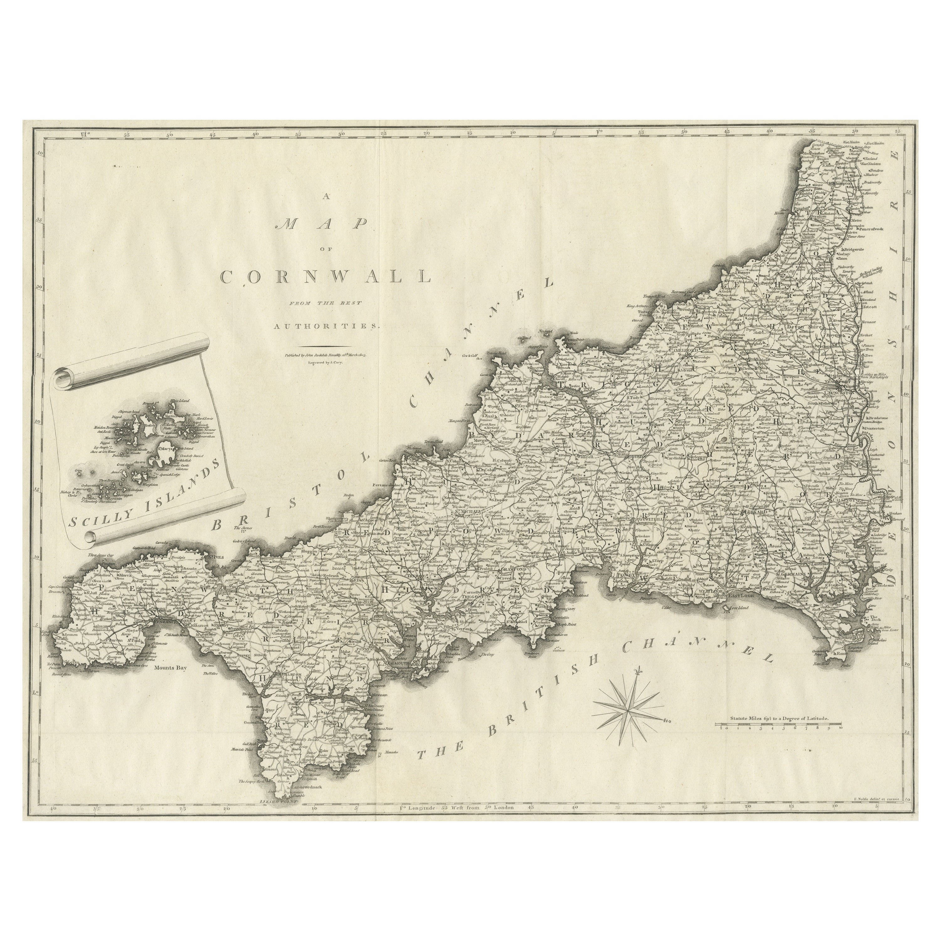
- Large Antique County Map of Cornwall and the Isles of Scilly, EnglandLocated in Langweer, NLAntique map titled 'A Map of Cornwall from the best Authorities'. Original old county map of Cornwall, England. With inset map of the Scilly Islands. Engraved by John Cary. Originate...Category
Antique Early 19th Century Maps
MaterialsPaper
- Antique Map of New JerseyLocated in Langweer, NLAntique map titled 'Colton's New Jersey'. This rare hand colored map of New Jersey is a copper plate engraving dating to 1855. Produced by the import...Category
Antique Mid-19th Century Maps
MaterialsPaper
- Antique Map of the Islands Within the Queen Charlotte's IslandsLocated in Langweer, NLAntique map titled 'Cote Septentrional de la plus grande des Isles de la Reine Charlotte (..)'. Map and coastal view of the islands within the Queen Charlotte's Islands (Santa Cruz I...Category
Antique Late 18th Century Maps
MaterialsPaper
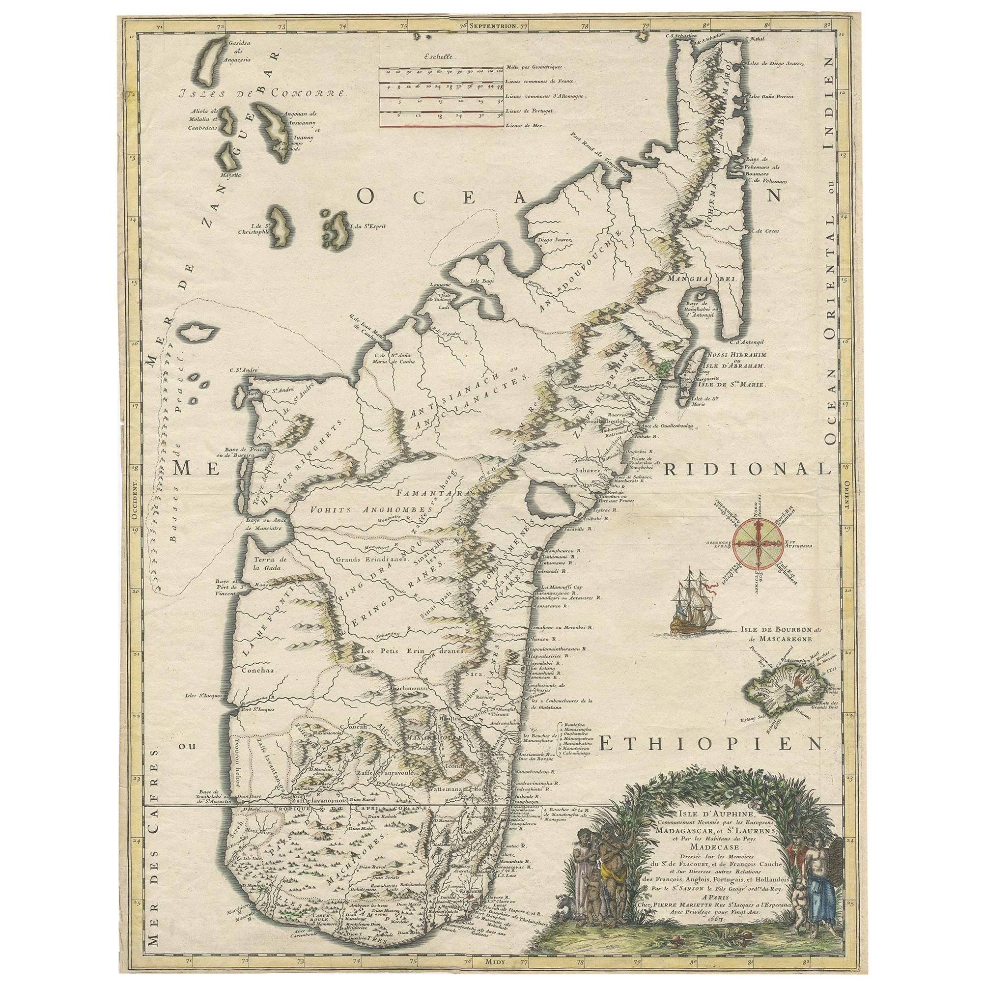
- Beautiful Antique Map of Madagascar, The Comoros Islands & Reunion Island, 1667Located in Langweer, NLAntique map titled 'Isle d'Auphine, communement Nommée par les Europeens Madagascar, et St. Laurens, et par les Habitans du pays Madecase'. Beautiful map of Madagascar...Category
Antique 1660s Maps
MaterialsPaper
- Antique Map of the Atlantic Islands, 1817Located in Langweer, NLAntique map titled 'Atlantic Islands'. Large map of the Atlantic Islands include the Cape Verde islands, Canary islands, Azore islands and Madeira islands. Also included a view of th...Category
Antique Early 19th Century Maps
MaterialsPaper
- Antique Map of Buru Island, Indonesia, c.1725Located in Langweer, NLAntique map titled 'Boero'. Original antique map of Buru island. With an inset of the lake on top of the inland mountain. This map originates from Valentyn's 'Oud en Nieuw Oost Indie...Category
Antique 18th Century Maps
MaterialsPaper


Recently Viewed
View AllMore Ways To Browse
Georgia Map
Antique Georgia Maps
Antique Georgia Map
Maps Of Georgia
Antique Map Of Georgia
Guernsey England
Map Of Boston
Boston Map
Caribbean Antique Furniture
James Johnston
Johnston James
Large Map Of London
Hebrew Antique
18th Century Antique Mexican
Caribbean Antiques
Victorian Compass
Antique Collectors Australia
Framed Atlas Map