Items Similar to Martinique Island in the Caribbean by Bellin Original Original Antique Map, 1780


Want more images or videos?
Request additional images or videos from the seller
1 of 6
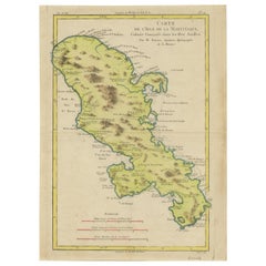
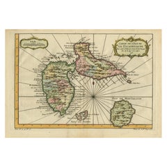
Martinique Island in the Caribbean by Bellin Original Original Antique Map, 1780
About the Item
This mid-18th century map, "Carte de l'Isle de la Martinique pour servir a l'historie generale des voyages," was issued in 1780 by M. Bellin in Paris. It presents a detailed and visually captivating depiction of the Island of Martinique within the context of the Caribbean and the Lesser Antilles.
**Title:** Carte de l'Isle de la Martinique pour servir a l'historie generale des voyages
**Issuer:** M. Bellin
**Date:** 1780
**Location Coverage:** North America, Caribbean, Martinique, Lesser Antilles
This engraved map is notable for its pleasing aesthetics, featuring lovely hand coloring that enhances its visual appeal. The inclusion of a scroll cartouche, an ornamental frame, and measurement lines adds a distinctive and visually appealing quality to the map.
Martinique, situated within the Lesser Antilles in the Caribbean, is presented with meticulous detail, showcasing geographical features, coastlines, settlements, and other notable landmarks. Bellin, known for his accuracy in cartography, crafted this map to serve as a geographical reference within the broader context of historical voyages and exploration.
The combination of detailed cartographic information and artistic embellishments, such as hand coloring and decorative elements, makes this map not only a valuable geographical document but also a visually pleasing piece of cartographic art from the mid-18th century.
Notice that the direction "north" is shown by the arrow on the diagonal line in the upper left part of the image. Map is very detailed showing inland roads.
- Dimensions:Height: 9.85 in (25 cm)Width: 13.39 in (34 cm)Depth: 0 in (0.02 mm)
- Materials and Techniques:Paper,Engraved
- Period:
- Date of Manufacture:1780
- Condition:Good condition, consisdering its age. Original fold lines as issued. One small light brown spot in lower margin. Attractive colors.
- Seller Location:Langweer, NL
- Reference Number:
About the Seller
5.0
Platinum Seller
These expertly vetted sellers are 1stDibs' most experienced sellers and are rated highest by our customers.
Established in 2009
1stDibs seller since 2017
1,922 sales on 1stDibs
Typical response time: <1 hour
- ShippingRetrieving quote...Ships From: Langweer, Netherlands
- Return PolicyA return for this item may be initiated within 14 days of delivery.
More From This SellerView All
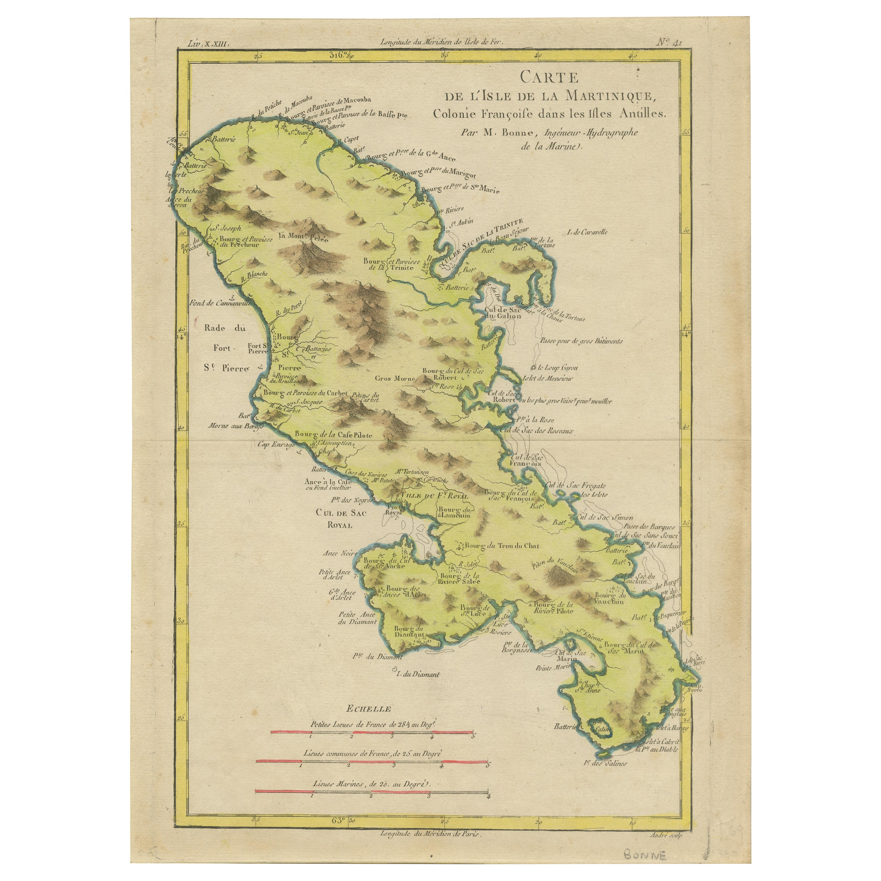
- Original Antique Map of Martinique Island In The West Indies by Bonne, circa1780Located in Langweer, NLAntique map titled 'Carte de l'Isle de la Martinique Colonie Francoise dans les Isles Antilles'. Detailed map of the French Island of Martinique. Many towns and harbours, anchor pl...Category
Antique 18th Century Maps
MaterialsPaper
- Antique Map of the Maluku Islands by Bellin, c.1750By Jacques-Nicolas BellinLocated in Langweer, NLAntique map titled 'Carte Particuliere des Isles Moluques'. This map depicts the islands of Herij, Ternate, Tidor, Pottebackers, Timor, Machian and Bachian. The Moluccan islands were...Category
Antique 18th Century Maps
MaterialsPaper
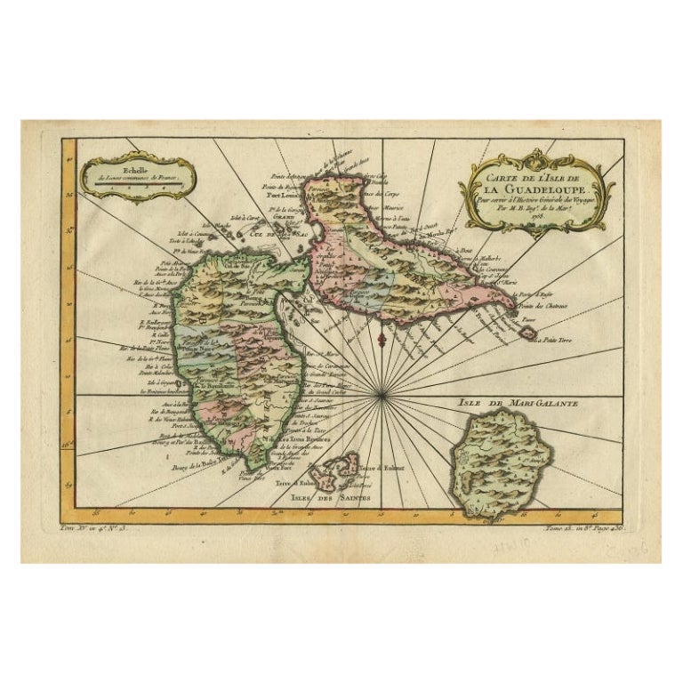
- Antique Map of Guadeloupe, Island in the Caribbean, c.1757Located in Langweer, NLAntique map titled 'Carte de L'Isle de la Guadeloupe'. A very decorative map of Guadeloupe in the Caribbean, adorned with rhumb lines, fleur-de-lys, and two decorative rococo-style...Category
Antique 18th Century Maps
MaterialsPaper
- Detailed Antique Map of the Windward Islands in the CaribbeanBy Covens & MortierLocated in Langweer, NLAntique map titled 'Carte des Antilles Francoises et des Isles Voisines'. Original antique map of the French Antilles, covering an area stretching from Guadeloupe in the north to Gre...Category
Antique Early 18th Century Maps
MaterialsPaper
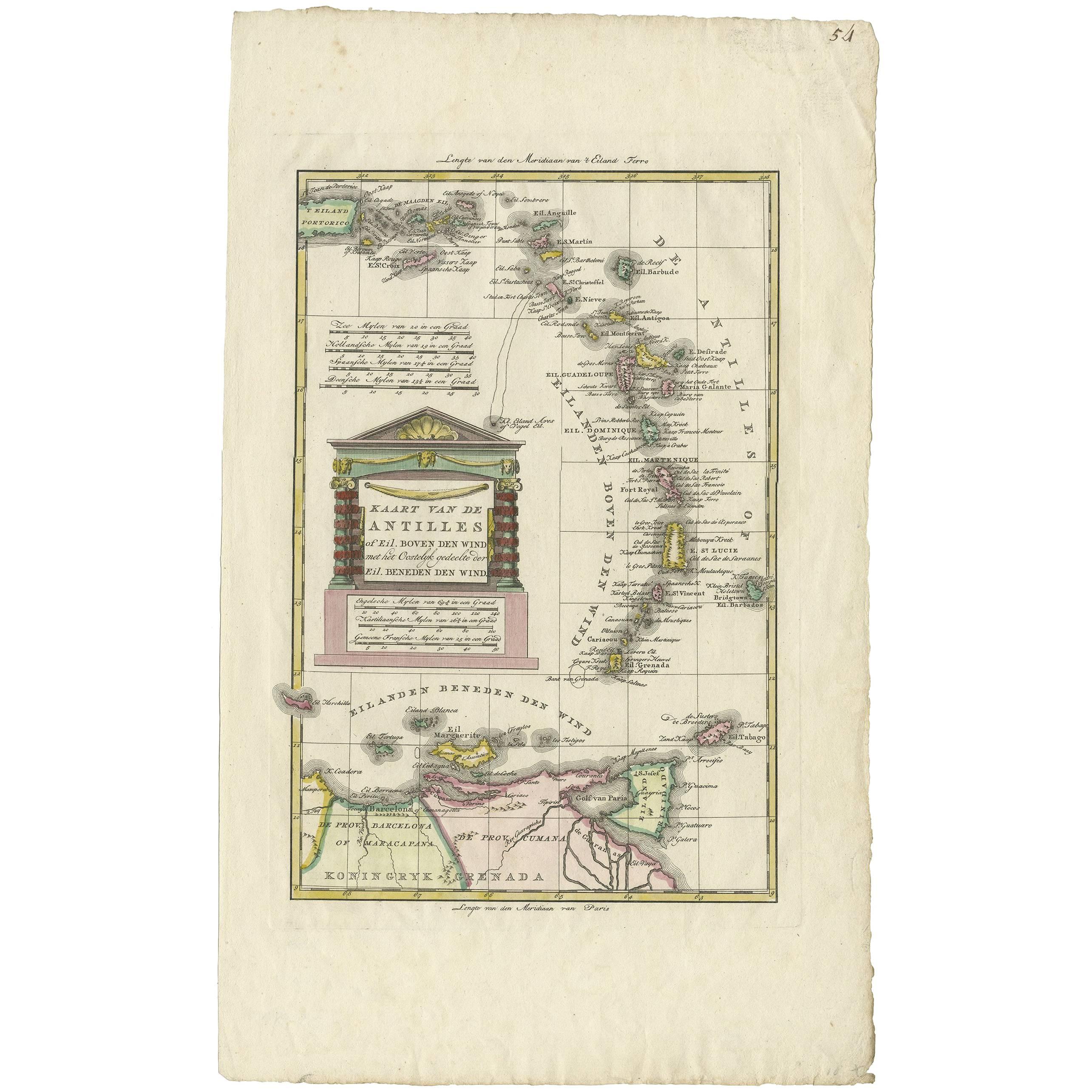
- Antique Map of the Dutch Antilles 'Caribbean' by R. Bonne, circa 1780Located in Langweer, NLAntique map titled 'Kaart van de Antilles (..)'. Rare edition of this map illustrating the Dutch Antilles (Caribbean). Published by R. Bonne, circa 1780. T...Category
Antique Late 18th Century Maps
MaterialsPaper
- Antique Map of Gorée Island ‘Senegal’ by J.N. Bellin, 1764Located in Langweer, NLNautical antique chart of Gorée Senegal including a letter key to the island's fortifications. Gorée is known as the location of the House of Slaves built by an Afro-French Métis fam...Category
Antique Mid-18th Century Maps
MaterialsPaper


You May Also Like
- Original Antique Map of Italy. C.1780Located in St Annes, LancashireGreat map of Italy Copper-plate engraving Published C.1780 Unframed.Category
Antique Early 1800s English Georgian Maps
MaterialsPaper

- Original Antique Map of Asia. C.1780Located in St Annes, LancashireGreat map of Asia Copper-plate engraving Published C.1780 Two small worm holes to right side of map Unframed.Category
Antique Early 1800s English Georgian Maps
MaterialsPaper

- Original Antique Map of India. C.1780Located in St Annes, LancashireGreat map of India Copper-plate engraving Published C.1780 Three small worm holes to right side of map and one bottom left corner Unframed.Category
Antique Early 1800s English Georgian Maps
MaterialsPaper

- Original Antique Map of South America. C.1780Located in St Annes, LancashireGreat map of South America Copper-plate engraving Published C.1780 Two small worm holes to left side of map Unframed.Category
Antique Early 1800s English Georgian Maps
MaterialsPaper
- Map Colonies Francaises Martinique, 1845Located in BUNGAY, SUFFOLKColonies Francaises, Martinique, Amerique DU SUD Geographie et Statistique par V.Levasseur. Ing'r Geographe. Illustre par Raymond Bonheur, peintre. Grave par Laguihermie, Rue St...Category
Antique 19th Century French Maps
MaterialsPaper
- St. Christophe 'St. Kitts' Island: An 18th Century Hand-colored Map by BellinBy Jacques-Nicolas BellinLocated in Alamo, CAJacques Bellin's copper-plate map of the Caribbean island of Saint Kitts entitled "Carte De De l'Isle St. Christophe Pour servir á l'Histoire Genle. des V...Category
Antique Mid-18th Century French Maps
MaterialsPaper


Recently Viewed
View AllMore Ways To Browse
Antique Compass France
John Speed Isle Of Wight Maps
Compass France
Isle Of Wight Maps
Old French Map
Ancient Map Of Israel
John Tallis Map
Austria Hungary Map
Kiribati Islands Map
Map Of Kiribati Islands
Montana Maps
Oman Map
Palliser Furniture
Barbados Map
Map Of Barbados
Britton And Rey Lithograph
Christoph Weigel On Sale
Clivia Ducatus Et Ravestein Dominium