Items Similar to Original Antique Map of Martinique Island In The West Indies by Bonne, circa1780


Want more images or videos?
Request additional images or videos from the seller
1 of 6
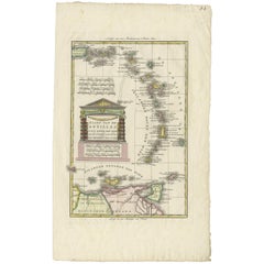
Original Antique Map of Martinique Island In The West Indies by Bonne, circa1780
About the Item
Antique map titled 'Carte de l'Isle de la Martinique Colonie Francoise dans les Isles Antilles'. Detailed map of the French Island of Martinique.
Many towns and harbours, anchor places, lakes, rivers and mountains are shown. Source unknown, to be determined. Artists and Engravers: Rigobert Bonne (1727-1795 ) was one of the most important cartographers of the late 18th century. In 1773 he succeeded Jacques Bellin as Royal Cartographer to France in the office of the Hydrographer at the Depôt de la Marine. Working in his official capacity Bonne compiled some of the most detailed and accurate maps of the period. Bonne's work represents an important step in the evolution of the cartographic ideology away from the decorative work of the 17th and early 18th century towards a more detail oriented and practical aesthetic. With regard to the rendering of terrain Bonne maps bear many stylistic similarities to those of his predecessor, Bellin. However, Bonne maps generally abandon such common 18th century decorative features such as hand coloring, elaborate decorative cartouches, and compass roses. While mostly focusing on coastal regions, the work of Bonne is highly regarded for its detail, historical importance, and overall aesthetic appeal.
Artist: Rigobert Bonne (1727-1795 ) was one of the most important cartographers of the late 18th century. In 1773 he succeeded Jacques Bellin as Royal Cartographer to France in the office of the Hydrographer at the Depôt de la Marine. Working in his official capacity Bonne compiled some of the most detailed and accurate maps of the period. Bonne's work represents an important step in the evolution of the cartographic ideology away from the decorative work of the 17th and early 18th century towards a more detail oriented and practical aesthetic. With regard to the rendering of terrain Bonne maps bear many stylistic similarities to those of his predecessor, Bellin. However, Bonne maps generally abandon such common 18th century decorative features such as hand coloring, elaborate decorative cartouches, and compass roses. While mostly focusing on coastal regions, the work of Bonne is highly regarded for its detail, historical importance, and overall aesthetic appeal.
- Dimensions:Height: 13.59 in (34.5 cm)Width: 10.04 in (25.5 cm)Depth: 0 in (0.01 mm)
- Materials and Techniques:Paper,Engraved
- Period:
- Date of Manufacture:circa 1780
- Condition:Condition: Good, given age. Slight browned near around the edges, outside the image. Original middle fold as issued. General age-related toning and/or occasional minor defects from handling. Please study image carefully.
- Seller Location:Langweer, NL
- Reference Number:
About the Seller
5.0
Platinum Seller
These expertly vetted sellers are 1stDibs' most experienced sellers and are rated highest by our customers.
Established in 2009
1stDibs seller since 2017
1,919 sales on 1stDibs
Typical response time: <1 hour
- ShippingRetrieving quote...Ships From: Langweer, Netherlands
- Return PolicyA return for this item may be initiated within 14 days of delivery.
More From This SellerView All
- Antique Map of West Africa by R. Bonne, 1780Located in Langweer, NLAntique map titled 'Partie Occidentale De L'Ancien Continent Depuis Lisbonne Jusqua La Riviere De Sierra Leona Avec L'Isle de Madere, les Isles Canaries et celles Du Cap Verd'. Parts...Category
Antique Late 18th Century Maps
MaterialsPaper
- Antique Map of Italy by R. Bonne, circa 1780Located in Langweer, NLBeautiful map of Italy, Corsica, Sardinia and Sicily. Highly detailed, showing towns, rivers, some topographical features and political boundaries. Published by R. Bonne, circa 1780.Category
Antique Late 18th Century Maps
MaterialsPaper
- Antique Map of the East Indies by Bonne '1776'Located in Langweer, NLAntique map titled 'Indes IVe Feuille'. Very decorative original antique map of the East Indies. Covbers from the Gulf of Siam (Gulf of Thailand) and Malacca (Malaysia) eastward to i...Category
Antique Late 18th Century Maps
MaterialsPaper
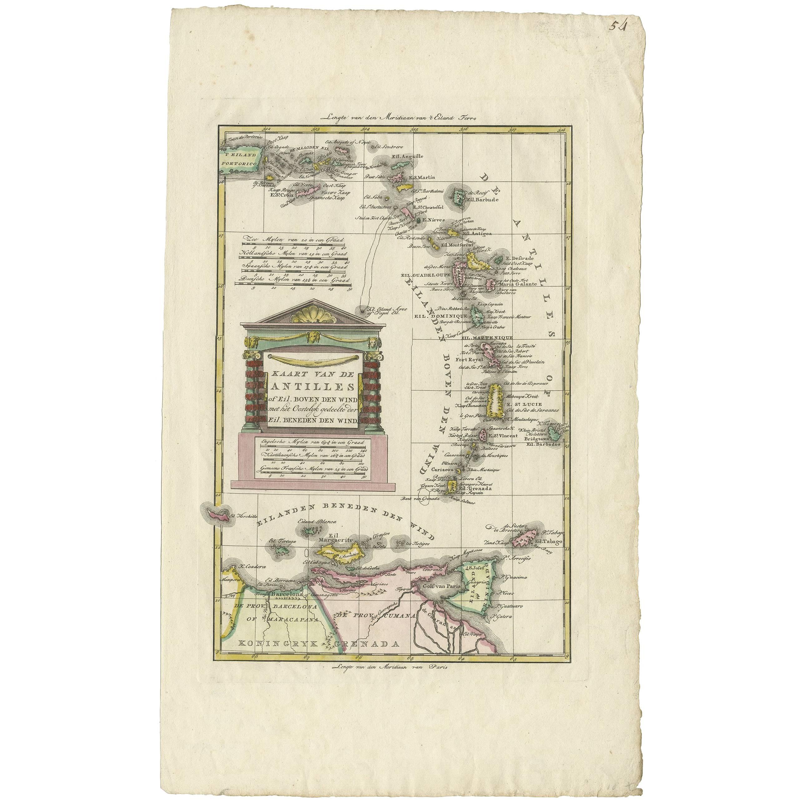
- Antique Map of the Dutch Antilles 'Caribbean' by R. Bonne, circa 1780Located in Langweer, NLAntique map titled 'Kaart van de Antilles (..)'. Rare edition of this map illustrating the Dutch Antilles (Caribbean). Published by R. Bonne, circa 1780. T...Category
Antique Late 18th Century Maps
MaterialsPaper
- Antique Map of Europe by R. Bonne, 1780Located in Langweer, NLA fine example of Rigobert Bonne and Guilleme Raynal’s 1780 map of Europe. Drawn by R. Bonne for G. Raynal’s Atlas de Toutes les Parties Connues du Globe Terrestre, Dressé pour l'His...Category
Antique Late 18th Century Maps
MaterialsPaper
- Antique Map of the Arabian Peninsula by Bonne 'c.1780'Located in Langweer, NLAntique map titled 'Carte de l'Arabie, du Golfe Persique, et de la Mer Rouge (..)'. Original antique map of the Arabian Peninsula, including the horn...Category
Antique Late 18th Century Maps
MaterialsPaper


You May Also Like
- Original Antique Map of Italy. C.1780Located in St Annes, LancashireGreat map of Italy Copper-plate engraving Published C.1780 Unframed.Category
Antique Early 1800s English Georgian Maps
MaterialsPaper

- Original Antique Map of Asia. C.1780Located in St Annes, LancashireGreat map of Asia Copper-plate engraving Published C.1780 Two small worm holes to right side of map Unframed.Category
Antique Early 1800s English Georgian Maps
MaterialsPaper

- Original Antique Map of India. C.1780Located in St Annes, LancashireGreat map of India Copper-plate engraving Published C.1780 Three small worm holes to right side of map and one bottom left corner Unframed.Category
Antique Early 1800s English Georgian Maps
MaterialsPaper

- Original Antique Map of South America. C.1780Located in St Annes, LancashireGreat map of South America Copper-plate engraving Published C.1780 Two small worm holes to left side of map Unframed.Category
Antique Early 1800s English Georgian Maps
MaterialsPaper
- Original Antique Map of Belgium by Tallis, Circa 1850Located in St Annes, LancashireGreat map of Belgium Steel engraving Many lovely vignettes Published by London Printing & Publishing Co. ( Formerly Tallis ), C.1850 Origin...Category
Antique 1850s English Maps
MaterialsPaper
- Large Original Antique Map of The West Indies by Sidney Hall, 1847Located in St Annes, LancashireGreat map of The West Indies Drawn and engraved by Sidney Hall Steel engraving Original colour outline Published by A & C Black. 1847 Unframed Free shipping.Category
Antique 1840s Scottish Maps
MaterialsPaper


Recently Viewed
View AllMore Ways To Browse
Ree Brown
Winkler Prins
Very Large Map
Antique American Victorian Furniture
A Plan City And Castle Of Batavia
Cheshire Map
John Speed Isle Of Wight Maps
Malacca Strait Map
Antique Map Of South Korea
Map Of Maine Et Loire
Mapp Plate
Marthas Vineyard Map
Nantucket Chart
Native American Mountie
Nicolaes Visscher II On Sale
Vintage Marthas Vineyard Map
W. & A.K. Johnston On Sale
Yemen 1789