Items Similar to Antique Map of West Africa by R. Bonne, 1780


Want more images or videos?
Request additional images or videos from the seller
1 of 5
Antique Map of West Africa by R. Bonne, 1780
About the Item
Antique map titled 'Partie Occidentale De L'Ancien Continent Depuis Lisbonne Jusqua La Riviere De Sierra Leona Avec L'Isle de Madere, les Isles Canaries et celles Du Cap Verd'. Parts of the Sahara Desert, Sierra Leona, Canary Islands and Africa. Drawn by R. Bonne for G. Raynal’s Atlas de Toutes les Parties Connues du Globe Terrestre, Dressé pour l'Histoire Philosophique et Politique des Établissemens et du Commerce des Européens dans les Deux Indes.
- Dimensions:Height: 15.04 in (38.2 cm)Width: 10.24 in (26 cm)Depth: 0.02 in (0.5 mm)
- Materials and Techniques:
- Period:
- Date of Manufacture:1780
- Condition:Minor fading. Please study image carefully.
- Seller Location:Langweer, NL
- Reference Number:
About the Seller
5.0
Platinum Seller
These expertly vetted sellers are 1stDibs' most experienced sellers and are rated highest by our customers.
Established in 2009
1stDibs seller since 2017
1,916 sales on 1stDibs
Typical response time: <1 hour
- ShippingRetrieving quote...Ships From: Langweer, Netherlands
- Return PolicyA return for this item may be initiated within 14 days of delivery.
More From This SellerView All
- Antique Map of Europe by R. Bonne, 1780Located in Langweer, NLA fine example of Rigobert Bonne and Guilleme Raynal’s 1780 map of Europe. Drawn by R. Bonne for G. Raynal’s Atlas de Toutes les Parties Connues du Globe Terrestre, Dressé pour l'His...Category
Antique Late 18th Century Maps
MaterialsPaper
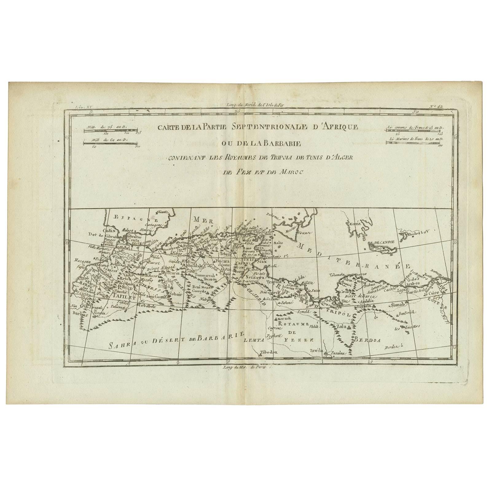
- Antique Map of Northern Africa "Barbary Coast" by R. Bonne, circa 1780Located in Langweer, NLA fine example of Rigobert Bonne and Guilleme Raynal’s 1780 map of northwestern Africa or the Barbary Coast. Includes the modern day countries of Morocco, Algeria, Tunisia, Libya, and parts of adjacent Spain, Italy and Greece. This map was made in response to European interest in the region due to coastal attacks and incursions by the Barbary Pirates...Category
Antique Late 18th Century Maps
MaterialsPaper
- Antique Map of Italy by R. Bonne, circa 1780Located in Langweer, NLBeautiful map of Italy, Corsica, Sardinia and Sicily. Highly detailed, showing towns, rivers, some topographical features and political boundaries. Published by R. Bonne, circa 1780.Category
Antique Late 18th Century Maps
MaterialsPaper
- Antique Map of the Arabian Peninsula by Bonne 'c.1780'Located in Langweer, NLAntique map titled 'Carte de l'Arabie, du Golfe Persique, et de la Mer Rouge (..)'. Original antique map of the Arabian Peninsula, including the horn...Category
Antique Late 18th Century Maps
MaterialsPaper
- Antique Map of the Arabian Peninsula by Bonne 'c.1780'Located in Langweer, NLAntique map titled 'Carte de l'Arabie, du Golfe Persique, et de la Mer Rouge (..)'. Original antique map of the Arabian Peninsula, including the horn...Category
Antique Late 18th Century Maps
MaterialsPaper
- Antique Map of the Russian Empire by R. Bonne, 1780Located in Langweer, NLAntique map titled 'Carte de l'Empire de Russie.' Drawn by R. Bonne for G. Raynal’s Atlas de Toutes les Parties Connues du Globe Terrestre, Dressé pour l'Histoire Philosophique et Po...Category
Antique Late 18th Century Maps
MaterialsPaper


You May Also Like
- Original Antique Map of Italy. C.1780Located in St Annes, LancashireGreat map of Italy Copper-plate engraving Published C.1780 Unframed.Category
Antique Early 1800s English Georgian Maps
MaterialsPaper

- Original Antique Map of Asia. C.1780Located in St Annes, LancashireGreat map of Asia Copper-plate engraving Published C.1780 Two small worm holes to right side of map Unframed.Category
Antique Early 1800s English Georgian Maps
MaterialsPaper

- Original Antique Map of India. C.1780Located in St Annes, LancashireGreat map of India Copper-plate engraving Published C.1780 Three small worm holes to right side of map and one bottom left corner Unframed.Category
Antique Early 1800s English Georgian Maps
MaterialsPaper

- Original Antique Map of South America. C.1780Located in St Annes, LancashireGreat map of South America Copper-plate engraving Published C.1780 Two small worm holes to left side of map Unframed.Category
Antique Early 1800s English Georgian Maps
MaterialsPaper
- 17th Century Hand-Colored Map of West Africa by Mercator/HondiusLocated in Alamo, CAA 17th century hand-colored map entitled "Guineae Nova Descriptio" by Gerard Mercator and Jodocus Hondius, published in their 'Atlas Minor' in Amsterdam in 1635. It is focused on the...Category
Antique Mid-17th Century Dutch Maps
MaterialsPaper
- West Coast of Africa, Guinea & Sierra Leone: An 18th Century Map by BellinBy Jacques-Nicolas BellinLocated in Alamo, CAJacques Bellin's copper-plate map entitled "Partie de la Coste de Guinee Dupuis la Riviere de Sierra Leona Jusquau Cap das Palmas", depicting the coast of Guinea and Sierra Leone in ...Category
Antique Mid-18th Century French Maps
MaterialsPaper


