
West Africa Map

3
to
16
94
85
72
53
44
42
37
27
21
20
19
11
9
9
8
7
7
7
6
6
6
5
5
5
3
2
2
2
2
2
2
2
2
2
1
1
1
1
1
1
1
1
1
1
1
1
1
1
1
40
8
3
3
3
Sort By
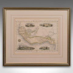
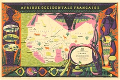
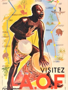
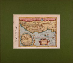
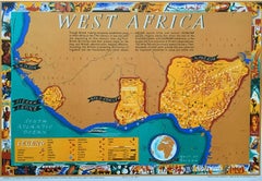
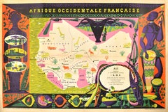
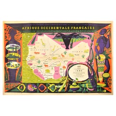
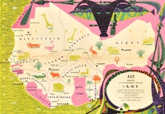
Original Vintage Poster French West Africa Map Afrique Occidentale Francaise Art
By alain cornic
Located in London, GB
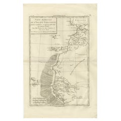
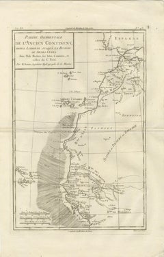
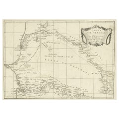
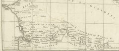
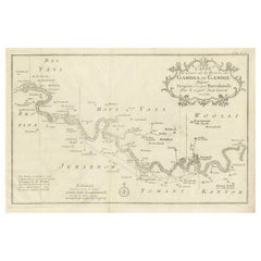
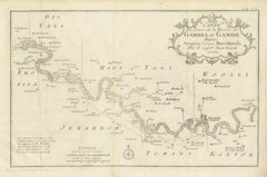
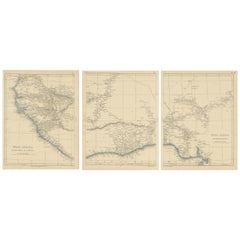
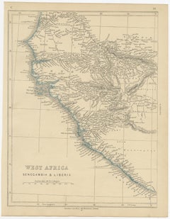
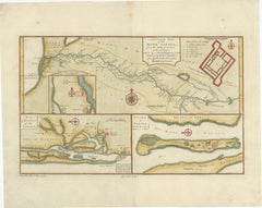
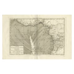
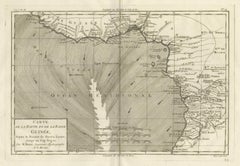
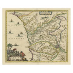
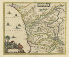
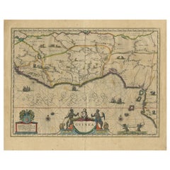
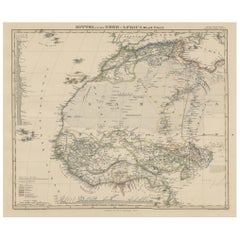
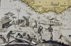
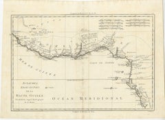
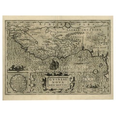
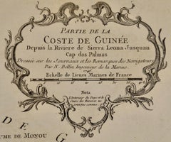
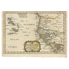
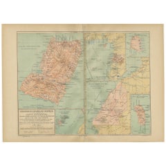
Original vintage poster featuring an illustrated map of French West Africa / Afrique Occidentale
Category

Vintage 1950s French Posters

Materials

Paper

Antique Map of Senegal, West Africa
Located in Langweer, NL
Original antique map titled 'Carta del Senegal'. Antique map of Senegal, West Africa. This map
Category

Antique Mid-18th Century Maps

Materials

Paper

Antique Map of Senegal, West Africa
H 10.04 in W 14.49 in D 0.02 in
Antique Map of Gambia, West Africa
Located in Langweer, NL
, West Africa, surrounded by Senegal with decorative title based on information supplied by Captain John
Category

Antique Mid-18th Century Maps

Materials

Paper

Antique Map of Gambia, West Africa
H 9.97 in W 14.97 in D 0.02 in
Antique Map of West Africa by Lowry, 1852
Located in Langweer, NL
Antique map titled 'West Africa'. Three individual sheets of West Africa. This map originates from
Category

Antique Mid-19th Century Maps

Materials

Paper

Antique Map of West Africa by Lowry, 1852
H 12.21 in W 9.65 in D 0.02 in
Antique Lithography Map, West Africa, English, Framed, Cartography, Victorian
Located in Hele, Devon, GB
This is an antique lithography map of Western Africa. An English, framed atlas engraving of
Category

Antique Mid-19th Century British Early Victorian Maps

Materials

Wood

Antique Map of the West Coast of Africa, 1771
By Rigobert Bonne
Located in Langweer, NL
qu'ils sont connus'. Map of the West Coast of Africa. Covers from the Cape Verde Islands eastward to the
Category

Antique 18th Century Maps

Materials

Paper

Antique Map of West Africa by R. Bonne, 1780
Located in Langweer, NL
Antique map titled 'Partie Occidentale De L'Ancien Continent Depuis Lisbonne Jusqua La Riviere De
Category

Antique Late 18th Century Maps

Materials

Paper

Antique Map of West Africa by R. Bonne, 1780
H 15.04 in W 10.24 in D 0.02 in
Antique Map of West Africa, focused on the Congo and Angola
Located in Langweer, NL
portion of West Africa, focused on the Congo and Angola. The map is centered on the Zaire River (Congo
Category

Antique Late 17th Century Maps

Materials

Paper

Antique Map of Guinea in West Africa by Blaeu, c.1638
Located in Langweer, NL
Antique map titled 'Guinea'. Decorative map of West Africa, including numerous animals in the
Category

Antique 17th Century Maps

Materials

Paper

17th Century Hand-Colored Map of West Africa by Mercator/Hondius
Located in Alamo, CA
A 17th century hand-colored map entitled "Guineae Nova Descriptio" by Gerard Mercator and Jodocus
Category

Antique Mid-17th Century Dutch Maps

Materials

Paper

Antique Map of North and West Africa by J.B. Elwe, 1792
Located in Langweer, NL
Beautiful richly engraved map of North and West Africa, based upon the earlier maps of De L'Isle
Category

Antique Late 19th Century Maps

Materials

Paper

West Africa Entitled "Guinea Propria": An 18th Century Hand Colored Homann Map
By Johann Baptist Homann
Located in Alamo, CA
This is a scarce richly hand colored copper plate engraved map of Africa entitled "Guinea Propria
Category

Antique Mid-18th Century German Maps

Materials

Paper

Old Decorative Map of the West African Coast & St. Thomae Island, c.1600
Located in Langweer, NL
Antique map titled 'Guineae Nova Descriptio.' This very decorative map shows the West African
Category

Antique Early 1600s Maps

Materials

Paper

West Coast of Africa, Guinea & Sierra Leone: An 18th Century Map by Bellin
By Jacques-Nicolas Bellin
Located in Alamo, CA
Sierra Leona Jusquau Cap das Palmas", depicting the coast of Guinea and Sierra Leone in West Africa
Category

Antique Mid-18th Century French Maps

Materials

Paper

Antique Map of South American, The West Indies & Most of Africa, Ca.1775
Located in Langweer, NL
, but includes most of Africa, the southern part of North America and the West Indies. Arrows in the
Category

Antique 1770s Maps

Materials

Paper

Map & Views of the Cape Verde Islands, in the Atlantic Ocean, West-Africa, 1775
Located in Langweer, NL
view of Praya Bay (..)'. Map and views of the Cape Verde islands, in the Atlantic Ocean west of
Category

Antique 1770s Maps

Materials

Paper

Map of the West African coast from the North of Mauretania to Guinee, 1788
Located in Langweer, NL
Antique map titled 'Particular Map of the Western Coast of Africa, from Cape Blanco to Cape de
Category

Antique 1780s Maps

Materials

Paper

Antique Map of the West African Coast and the Cape Verde Islands, c.1680
Located in Langweer, NL
Antique map Africa titled 'Isles du Cap Verd Coste et Pays des Negres'. Antique map of the coast of
Category

Antique 17th Century Maps

Materials

Paper

Rare Antique Map of Southwestern Europe and West Africa by V.M. Coronelli, 1692
By Vincenzo Coronelli
Located in Langweer, NL
Beautiful hand-colored example of the Southwestern Europe and West Africa globe gore from
Category

Antique Late 17th Century Maps

Materials

Paper

Antique Map of the Cape Verde Islands and Part of Senegal, West Africa, 1690
Located in Langweer, NL
Antique map titled 'Bocche del Fivme Negro et Isole di Capo Verde'. Beautiful double-page map of
Category

Antique 17th Century Maps

Materials

Paper

Dutch Antique Map of the West Coast of Africa, to the Cape of Good Hope, 1747
Located in Langweer, NL
Antique map of the Coast of Africa titled 'Kaart van de West Kust van Afrika (..)'. Map of the
Category

Antique 1740s Maps

Materials

Paper

Antique Map of Northwest Africa by Bartholomew, 1922
Located in Langweer, NL
Antique map of Africa titled 'North-West Africa'. Old map of north-west Africa depicting Morocco
Category

20th Century Maps

Materials

Paper

Echoes of Empire: Spanish Territories in West Africa, 1903
Located in Langweer, NL
This is a historical map showing Spanish possessions in West Africa from the year 1903. The map
Category

Antique Early 1900s Maps

Materials

Paper

Echoes of Empire: Spanish Territories in West Africa, 1903
Free Shipping
H 14.77 in W 20.08 in D 0 in
Bay of Arguin, West Coast of Africa from Cape Blanco to Tanit, Africa, 1747
Located in Langweer, NL
Arguin on the West Coast of Africa from Cape Blanco in the north to Tanit in the south. This map
Category

Antique 1740s Maps

Materials

Paper

Antique Map of Mauritania 'Africa' by G. Ruscelli, 1574
Located in Langweer, NL
A very rare mid-16th century black and white map of North and West Africa called Mauritania by the
Category

Antique 16th Century Maps

Materials

Paper

Original Hand-Coloured Nautical Chart of West-Africa, c.1680
Located in Langweer, NL
impressive and decorative map of this part of Africa.
Category

Antique 17th Century Maps

Materials

Paper

Original Antique Coloured Map of Western Africa, Published in 1882
Located in Langweer, NL
This is a map of Western Africa from the 1882 Blackie & Son atlas. The map details the West African
Category

Antique 1880s Maps

Materials

Paper

Set of Three Antique Maps of Africa by Colton (circa 1855)
Located in Langweer, NL
Set of three individual maps of Africa including 'North West Africa', 'North Eastern Africa' and
Category

Antique Mid-19th Century Maps

Materials

Paper

Antique Map of the Coast of Northwest Africa by Dien, 1820
Located in Langweer, NL
Riviere de Sierra Leona'. Detailed map of Coastal North and West Africa, from Biafra and Sierra Leone
Category

Antique 19th Century Maps

Materials

Paper

Antique Map of Africa with a Decorative Dedication to the Dauphin, 1717
Located in Langweer, NL
Decouvertes (..).' This map is a reduced derivative of De Fer's wall map of Africa (1696-98) with its
Category

Antique 18th Century Maps

Materials

Paper

Antique Map of the City of Algiers and Surroundings in Northern Africa, 1773
Located in Langweer, NL
Antique print titled 'Plan van de Stad Algiers'. Old map of Algiers, also depicting surrounding
Category

Antique 18th Century Maps

Materials

Paper

Very Attractive Map of North and South America and Western Part of Africa, 1744
Located in Langweer, NL
western part of Africa and south west Europe. With full contemporary hand colouring. This map originates
Category

Antique 18th Century Maps

Materials

Paper

Attractive Antique Map of Western Africa with Lots of Details on the Coast, 1655
Located in Langweer, NL
veües jusques a present". Handsome map of Western Africa filled with information, much of it
Category

Antique 1650s Maps

Materials

Paper

Antique Map of the Dutch Gold Coast in Africa by Van den Bosch '1818'
Located in Langweer, NL
important Dutch colony in West Africa after Fort Elmina was captured from the Portuguese in 1637, but fell
Category

Antique Early 19th Century Maps

Materials

Paper

Rare Engraving of Dutch and Danish Forts on the West African Gold Coast, 1744
Located in Langweer, NL
the West African Gold Coast, Ghana; a) The Dutch Fort Croevecoeur at Accra, b) The Danish Fort
Category

Antique 1740s Maps

Materials

Paper

Antique Map of the Coast of Angola Up to Port Elizabeth in South Africa, 1675
Located in Langweer, NL
map depicts the coast of Angola, South-West Africa and South Africa up to Port Elizabeth. The
Category

Antique 1670s Maps

Materials

Paper

Original Afrique Occidentale - Africa horizontal vintage poster
Located in Spokane, WA
left and right, harps, clay pots, drums with the maps of West Africa map in the center. The region
Category

1950s Land Landscape Prints

Materials

Lithograph

Large Decorative Map of the Iberian Peninsula
Located in Langweer, NL
Islands and part of the north coast of Africa. The map is based on the cartography of Rodrigo Mendez Sylva
Category

Antique Mid-18th Century Maps

Materials

Paper

 Large Decorative Map of the Iberian Peninsula
 Large Decorative Map of the Iberian Peninsula
Free Shipping
H 19.61 in W 26.3 in D 0.02 in
Copper Engraved Grenada Map by John Thompson Published in 1810
Located in Langweer, NL
coloring, embodies a significant contribution to the category of Maps West Indies Whole. Crafted with
Category

Antique Early 19th Century Maps

Materials

Paper

Original Steel Engraved Map of French Colonies in America, 1854
Located in Langweer, NL
Antique map titled 'Colonies Francaises (en Amerique)'. Detailed map bordered by vignettes showing
Category

Antique Mid-19th Century Maps

Materials

Paper

Original Steel Engraved Map of French Colonies in America, 1854
Free Shipping
H 13.12 in W 18.71 in D 0.02 in
Antique Map of Edom, an Ancient Kingdom in Transjordan, 1773
Located in Langweer, NL
Antique print titled 'Idumea, of thet Land der Philistynen'. Old map of Edom, an ancient kingdom in
Category

Antique 18th Century Maps

Materials

Paper

Mediterranean Tapestry: A 19th Century Map of the Mediterranean Shores, 1882
Located in Langweer, NL
Europe down to the northern coastlines of Africa. The map is a vivid document of the time, with each
Category

Antique 1880s Maps

Materials

Paper

Antique Hand-Coloured Map of North and South America, ca.1765
Located in Langweer, NL
America, the western part of Africa and south west Europe. Source unknown, to be determined. Artists
Category

Antique 1760s Maps

Materials

Paper

Antique Map of Anjouan or Ndzuani Island, Part of The Comoros, 1749
Located in Langweer, NL
Antique map titled ‘Carte de L’Isle D’Anjouan - Kaart van 't Eiland Anjouan’. Original antique map
Category

Antique 18th Century Maps

Materials

Paper

St. Christophe 'St. Kitts' Island: An 18th Century Hand-colored Map by Bellin
By Jacques-Nicolas Bellin
Located in Alamo, CA
Jacques Bellin's copper-plate map of the Caribbean island of Saint Kitts entitled "Carte De De
Category

Antique Mid-18th Century French Maps

Materials

Paper

Antique Map of the Harbour of Praia, Santiago Island, Cape Verde, c.1750
Located in Langweer, NL
Antique map titled 'A Draught of ye Harbour of Praya in the Island St. Jago (..)'. Uncommon map
Category

Antique 18th Century Maps

Materials

Paper

Antique Map of Southern Asia with India, the Maldives, Ceylon and Arabia, c.1700
Located in Langweer, NL
, extending from Saudi Arabia and the Horn of Africa in the west to the Straits of Malacca, with the focus
Category

Antique Early 18th Century Maps

Materials

Paper

Rare Map of Six Coast Views and Anchorages of Sierra Leone and Indonesia, 1660
Located in Langweer, NL
This rare antique map includes six coastal elevation views of anchorages and bays favored by Dutch
Category

Antique 17th Century Maps

Materials

Paper

Islands of Diversity: Portugal's Atlantic Archipelagos in 1903
Located in Langweer, NL
Verde is an archipelago located off the west coast of Africa known for its Creole Portuguese-African
Category

Antique Early 1900s Maps

Materials

Paper

Very Large Hand-Drawn View of St Iago Cape Verde, by Frederici, 1783
Located in Amsterdam, NL
The largest recorded early modern panoramic view of Cape Verde, by “the best VOC map maker in South
Category

Antique Late 18th Century Cape Verdean Dutch Colonial Maps

Materials

Paper

Antique Engraving of the Island Nzwani or Anzuany of the Comoros Islands, 1726
Located in Langweer, NL
Historical titles: Ansjouan, Ansuany, Anjouan, Anzuani, Anzuany Country: Comoros The map is taken
Category

Antique 1720s Maps

Materials

Paper

Africa. North-West Part. Century Atlas antique vintage map
Located in Melbourne, Victoria
'The Century Atlas. Africa. Southern Part' Original antique map, 1903. Central fold as issued
Category

Early 20th Century Victorian More Prints

Materials

Lithograph

West Africa: 18th Century Hand-colored Homann Map Entitled "Guinea Propria"
By Johann Baptist Homann
Located in Alamo, CA
This is a scarce richly hand colored copper plate engraved map of Africa entitled "Guinea Propria
Category

1740s Other Art Style Prints and Multiples

Materials

Engraving

West Coast of Africa; Guinea & Sierra Leone: Bellin 18th Century Map
Located in Alamo, CA
This is a Jacques Bellin copper-plate map entitled "Partie de la Coste de Guinee Dupuis la Riviere
Category

1740s Old Masters Landscape Prints

Materials

Engraving

West Africa: A 17th Century Hand-Colored Map by Mercator/Hondius
By Gerard Mercator
Located in Alamo, CA
A 17th century hand-colored map entitled "Guineae Nova Descriptio" by Gerard Mercator and Jodocus
Category

1630s Landscape Prints

Materials

Engraving

Leo Vernon West Africa poster map 1948 Nigeria, Gold Coast, Sierra Leone, Gambia
By Leo Vernon
Located in London, GB
. Leo Vernon West Africa (British Empire 1948) Printed by J.Howitt & Son Ltd Lithographic poster map 20
Category

1940s Realist More Prints

Materials

Lithograph

Original Vintage Poster Sabena Belgian Airlines To Europe Asia Africa Travel Map
Located in London, GB
Original vintage pictorial travel map poster advertising Sabena Belgian Airlines flights to Europe
Category

Vintage 1950s Belgian Posters

Materials

Paper

Seminal guide to the East and West Indies, with 42 coloured maps and plates
By Jan Huygen van Linschoten
Located in ZWIJNDRECHT, NL
Seminal guide to the East and West Indies, with 42 double-page and folding plates, including 6 maps
Category

Antique Early 17th Century Dutch Dutch Colonial Books

Materials

Paper

"Choke II: Cape of Good Hope (South Africa) II" - ceramic - map - black & white
By Gregor Turk
Located in Atlanta, GA
served as a Peace Corps Volunteer in Liberia, West Africa. His work has been featured in numerous solo
Category

2010s Abstract Sculptures

Materials

Ceramic

Map of the Russian Empire: An Original 18th Century Hand-colored Map by E. Bowen
Located in Alamo, CA
Isles, Europe, North America, Africa, and Asia. He also created maps for several important atlases
Category

Mid-18th Century Old Masters Landscape Prints

Materials

Engraving

  • 1
Get Updated with New Arrivals
Save "West Africa Map", and we’ll notify you when there are new listings in this category.

West Africa Map For Sale on 1stDibs

Choose from an assortment of styles, material and more with respect to the west africa map you’re looking for at 1stDibs. Each west africa map for sale was constructed with extraordinary care, often using paper. Your living room may not be complete without a west africa map — find older editions for sale from the 18th Century and newer versions made as recently as the 19th Century. You’ll likely find more than one west africa map that is appealing in its simplicity, but Jacques-Nicolas Bellin and Vincenzo Coronelli produced versions that are worth a look.

How Much is a West Africa Map?

Prices for a west africa map start at $169 and top out at $2,959 with the average selling for $575.