Items Similar to Maritime and Terrestrial Survey of Spanish Santander in 1901, An Original Map

Want more images or videos?
Request additional images or videos from the seller
1 of 7
Maritime and Terrestrial Survey of Spanish Santander in 1901, An Original Map
About the Item
This antique map is a historical map of the province of Santander (currently known as Cantabria) from the year 1901. Santander is located along the northern coast of Spain, bordering the Cantabrian Sea.
This province is characterized by its rich history, stunning coastal landscapes, and the mountain ranges of the Cantabrian Cordillera. The city of Santander, which is the capital of the province, is situated on the coast and is known for its port and its importance as a commercial and cultural hub.
The map details the geographical features such as the river systems, including the Ebro and its tributaries, mountain ranges, and the infrastructure present at the time, like railroads and roads. The coastal areas, particularly the bays and beaches, would have been important for trade and fishing, contributing to the local economy.
The coat of arms depicted on the map represents the provincial identity, with the ship symbolizing maritime heritage and the royal crown reflecting historical ties to the Spanish monarchy.
- Dimensions:Height: 14.77 in (37.5 cm)Width: 20.08 in (51 cm)Depth: 0 in (0.02 mm)
- Materials and Techniques:
- Period:1900-1909
- Date of Manufacture:1901
- Condition:Good condition. Central vertical folding lines as issued. Aged paper with typically warm, yellowish-brown hue, especially around the edges. A light brown discoloring along the top of the fold. Check the images carefully.
- Seller Location:Langweer, NL
- Reference Number:
About the Seller
5.0
Platinum Seller
These expertly vetted sellers are 1stDibs' most experienced sellers and are rated highest by our customers.
Established in 2009
1stDibs seller since 2017
1,919 sales on 1stDibs
Typical response time: <1 hour
- ShippingRetrieving quote...Ships From: Langweer, Netherlands
- Return PolicyA return for this item may be initiated within 14 days of delivery.
More From This SellerView All
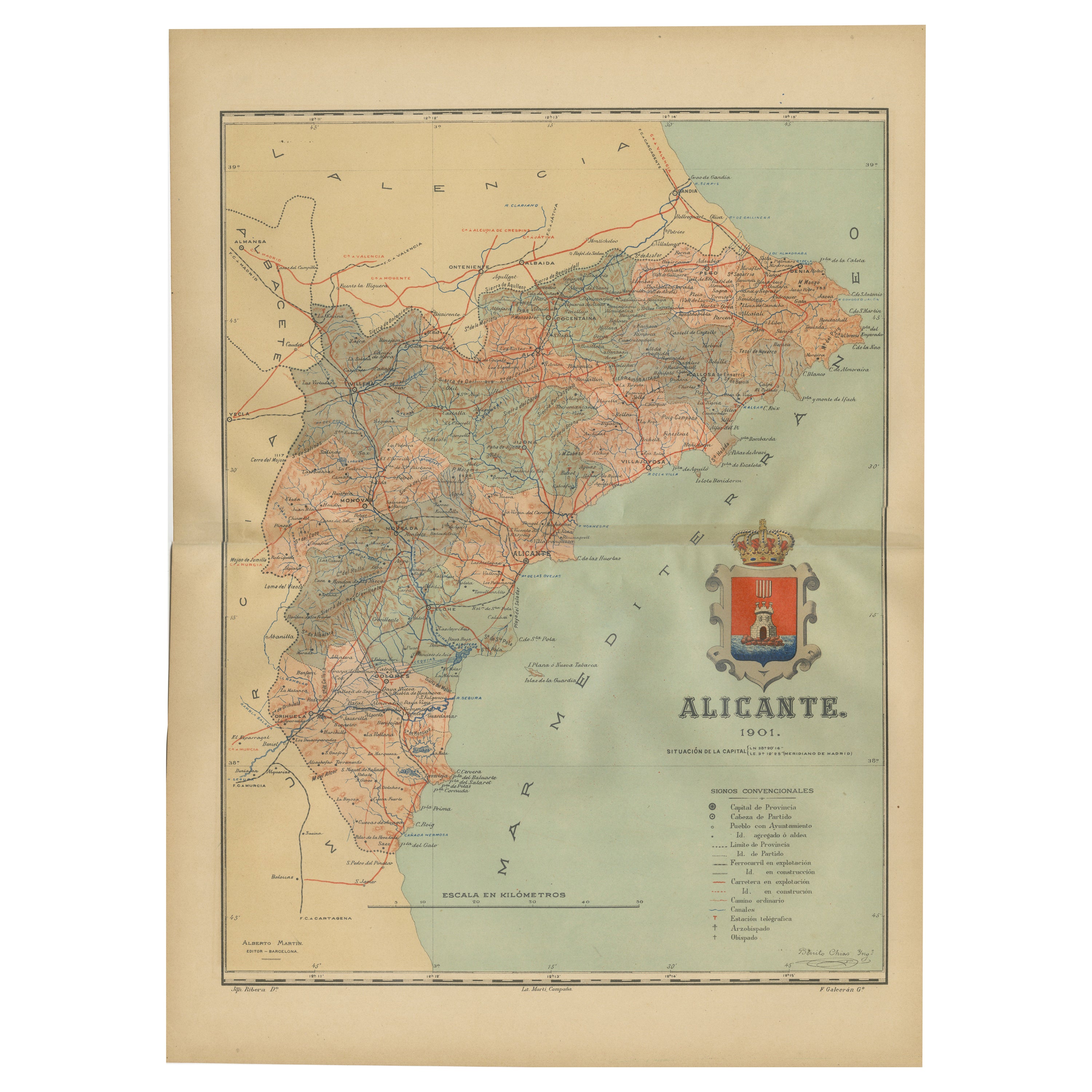
- Alicante in a 1901 Antique Map: Maritime Gateway of Spain's Costa BlancaLocated in Langweer, NLAn original antique map of the province of Alicante, dated 1901. It is part of the atlas series by D. Benito Chias y Carbo, featuring cartographic elements. Here are some characteri...Category
Antique Early 1900s Maps
MaterialsPaper
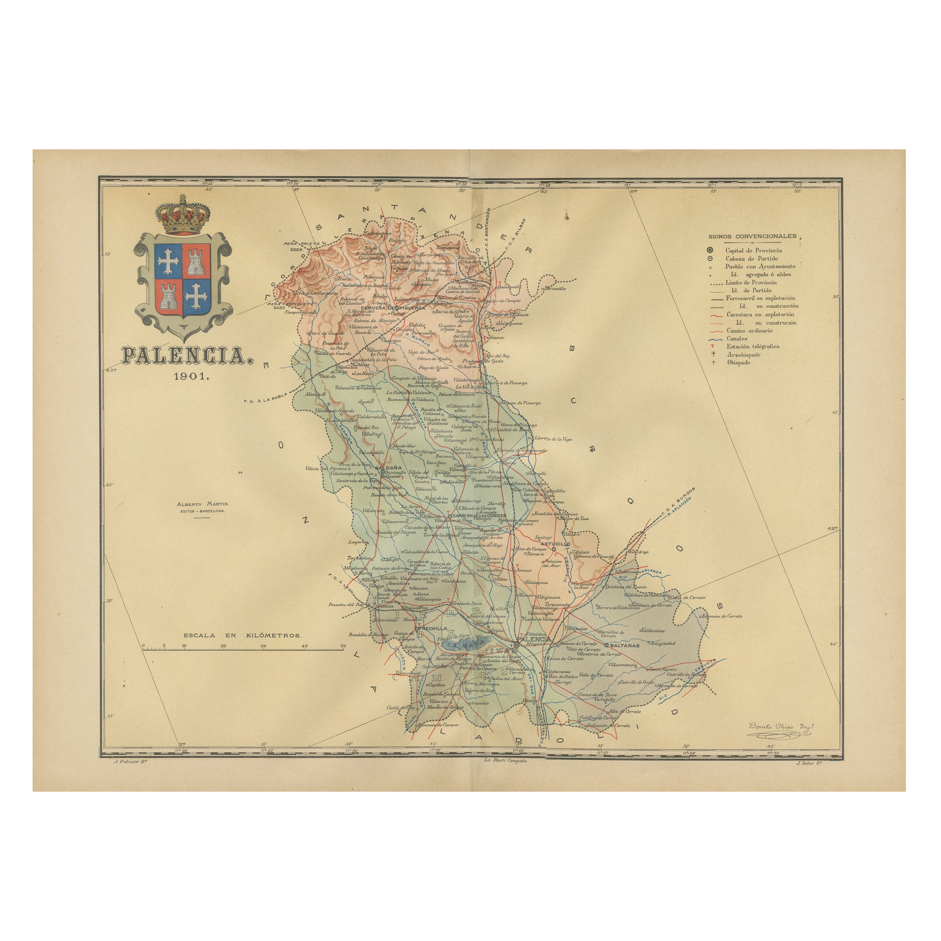
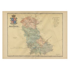
- Original Antique Map of Palencia Province, in Northern Spain, 1901Located in Langweer, NLThis historical map is of Palencia, a province in the northern part of Spain. Palencia is situated within the autonomous community of Castilla y León. It is bordered by the provinc...Category
Antique Early 1900s Maps
MaterialsPaper
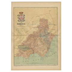
- Almería 1901: Coastal Contours and Landscapes in a Map of Southeastern SpainLocated in Langweer, NLAn original antique map of the province of Almería, Spain, from the year 1901. The Mediterranean Sea, labeled as "Mar Mediterraneo," forms the southeastern boundary of the province...Category
Antique Early 1900s Maps
MaterialsPaper
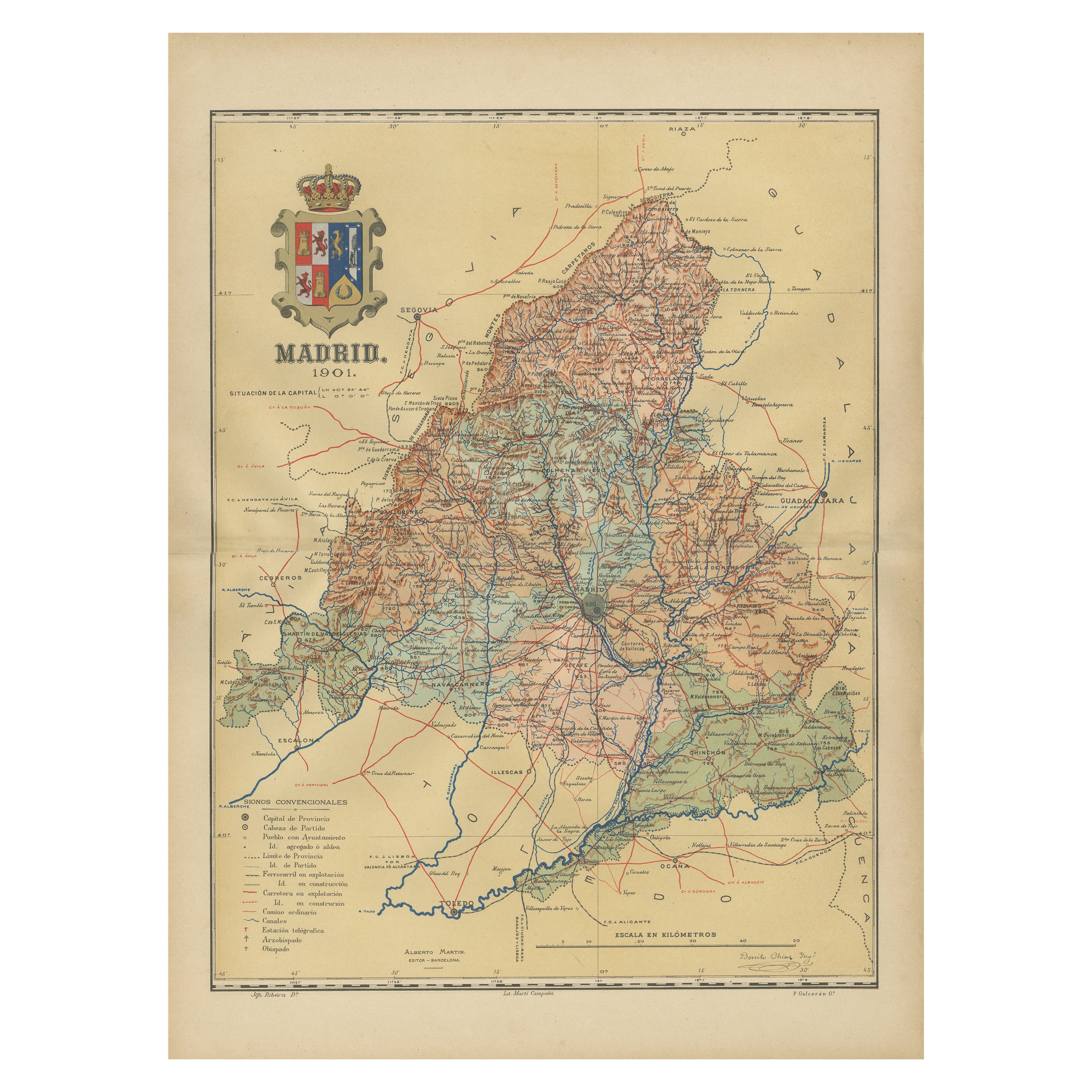
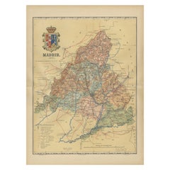
- Madrid 1901: A Historical Map of Spain's Capital ProvinceLocated in Langweer, NLThe map is of the province of Madrid, the capital region of Spain, as it appeared in 1901. Here are the key features it displays: The map shows the central part of Spain, with the Guadarrama mountain range prominently visible, marking the natural border to the north of Madrid. Blue lines likely indicate rivers, including the Manzanares River, which flows through Madrid, and the Jarama River, a tributary to the Tagus. Red lines depict the roads and railways, outlining the infrastructure that connects Madrid's various towns and cities within the province and beyond. Symbols and labels mark the locations of cities, towns, and villages, with Madrid itself likely being the focal point. Dotted lines may represent the administrative divisions within the province. The map includes a legend (Signos Convencionales) that explains the symbols used for provincial capitals, roads, railways, and other geographic features. The coat of arms of Madrid, featuring a bear and a strawberry tree (madroño), is prominently featured, symbolizing the city's and the province's historical coat of arms. About the province of Madrid: Madrid is not only the capital of Spain but also the heart of the Iberian Peninsula, both geographically and politically. The city is renowned for its rich repositories of European art, including the Prado Museum's works by Goya, Velázquez, and other Spanish masters. The province of Madrid is characterized by a blend of historical and modern elements, with a rich cultural life that includes theater, opera, and flamenco, as well as gastronomy that features a mix of traditional Spanish dishes and international cuisine...Category
Antique Early 1900s Maps
MaterialsPaper
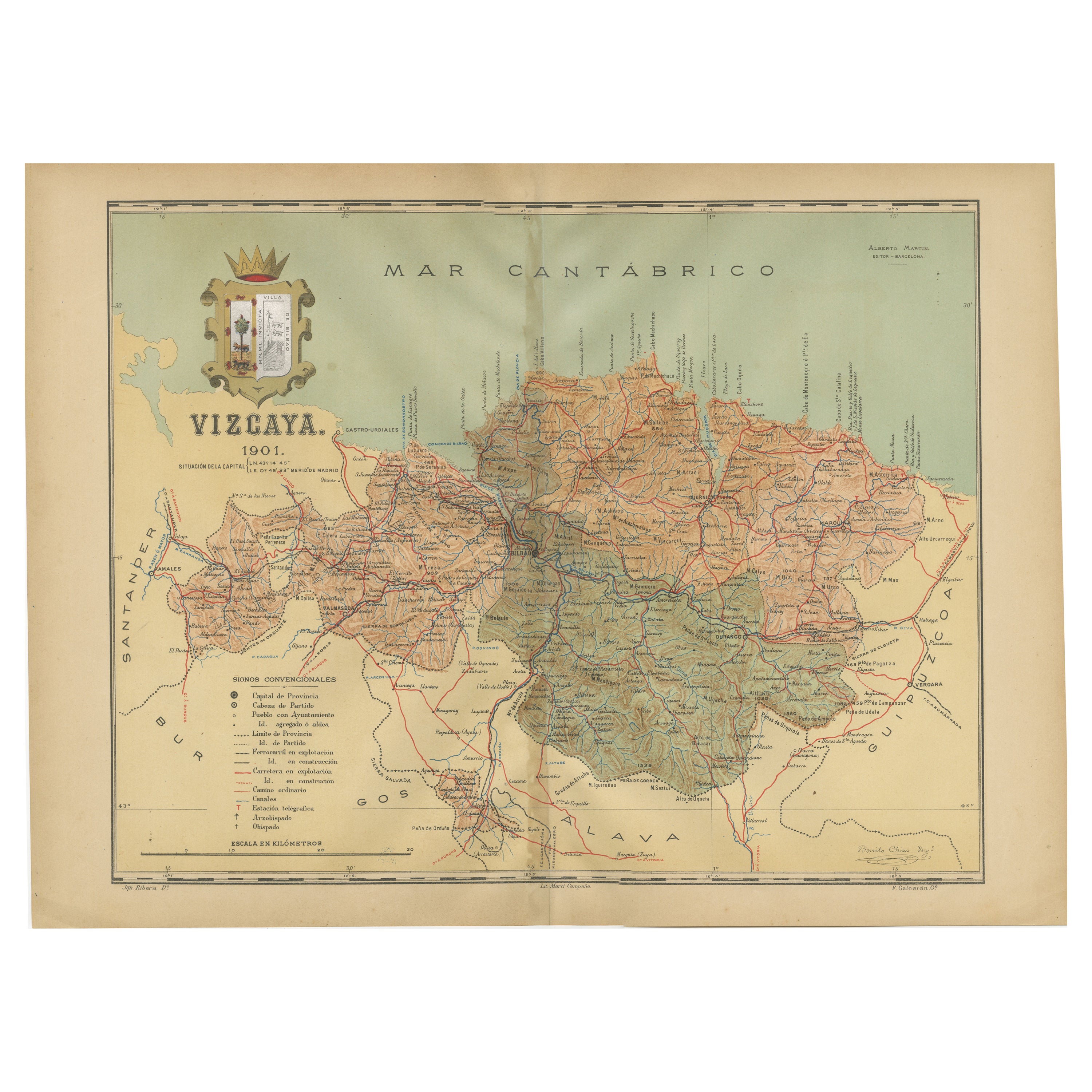
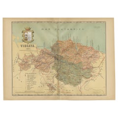
- Cartographic Heritage: The 1901 Map of the Vizcaya Province in SpainLocated in Langweer, NLThis is a historical map of the province of Vizcaya (Biscay) in Spain, dated 1901. The title on the map is "VIZCAYA. 1901." It shows the topographical details of the region with cont...Category
Antique Early 1900s Maps
MaterialsPaper
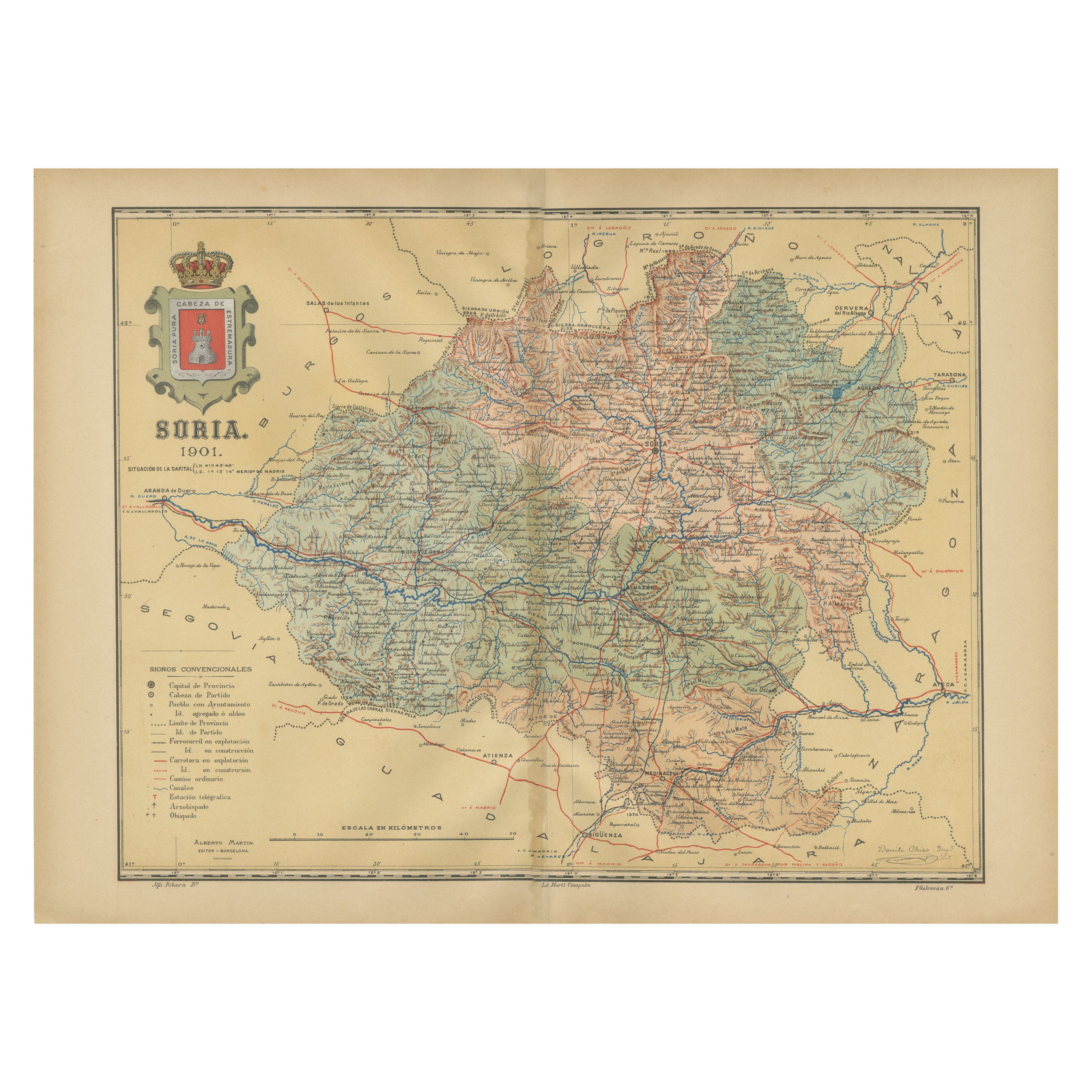
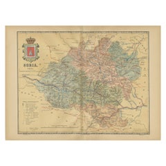
- Map of Soria Province, 1901: Detailed Cartography of Northeastern SpainLocated in Langweer, NLThe map is a historical map of the province of Soria from 1901. A decorative coat of arms enhances the aesthetic of the map, signifying the historical and cultural significance of ...Category
Antique Early 1900s Maps
MaterialsPaper

You May Also Like
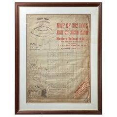
- Framed Original Land Map Survey of Tyler Park, Jersey City RailroadLocated in Lambertville, NJA framed and matted historical map of Tyler park jersey city New Jersey Railroad. The paper on canvas in later appropriate frame. Good condition with some creasing and age discolorat...Category
Antique 1870s American Posters
MaterialsCanvas, Glass, Wood
- Original Antique Map of Spain and Portugal, circa 1790Located in St Annes, LancashireSuper map of Spain and Portugal Copper plate engraving by A. Bell Published, circa 1790. Unframed.Category
Antique 1790s English Other Maps
MaterialsPaper
- 1856 U.S. Coast Survey Map of Chesapeake Bay and Delaware BayLocated in Colorado Springs, COPresented is U.S. Coast Survey nautical chart or maritime map of Chesapeake Bay and Delaware Bay from 1856. The map depicts the region from Susquehanna, Maryland to the northern Oute...Category
Antique 1850s American Maps
MaterialsPaper
- Large Original Vintage Map of Spain, circa 1920Located in St Annes, LancashireGreat map of Spain Original color. Good condition Published by Alexander Gross Unframed.Category
Vintage 1920s English Maps
MaterialsPaper
- Original Antique Map of Spain and Portugal by Thomas Clerk, 1817Located in St Annes, LancashireGreat map of Spain and Portugal Copper-plate engraving Drawn and engraved by Thomas Clerk, Edinburgh. Published by Mackenzie And Dent, 1817 Unframed.Category
Antique 1810s English Maps
MaterialsPaper
- Original Antique Map of Spain and Portugal, Engraved By Barlow, 1806Located in St Annes, LancashireGreat map of Spain And Portugal Copper-plate engraving by Barlow Published by Brightly & Kinnersly, Bungay, Suffolk. 1806 Unframed.Category
Antique Early 1800s English Maps
MaterialsPaper


Recently Viewed
View AllMore Ways To Browse
Map Of Old Armenia
Teak Wood Sphere
Nova Guinea Maps
Antique Map Of Illinois
Petite Point Hand Bag
Antique Map Of Southeastern Us
Antique Map Alabama
Antique Map Of Sydney
Malay Archipelago Map
Gambia Antique Map
Uruguay Antique Map
Guyana Antique Map
Ruscelli Map
Masque Theatre No
Nova Scotia Map
Antique Map Tuscany
Berkshire Antique Map
Cornwall Map