Items Similar to Almería 1901: Coastal Contours and Landscapes in a Map of Southeastern Spain

Want more images or videos?
Request additional images or videos from the seller
1 of 8
Almería 1901: Coastal Contours and Landscapes in a Map of Southeastern Spain
About the Item
An original antique map of the province of Almería, Spain, from the year 1901.
The Mediterranean Sea, labeled as "Mar Mediterraneo," forms the southeastern boundary of the province, with coastlines and port locations indicated.
The coat of arms of Almería is prominently displayed, incorporating the castle and the cross, which are historic symbols often associated with the Reconquista period in Spain.
Almería is a province located in the southeastern part of Spain, within the autonomous community of Andalusia. It shares its borders with the provinces of Granada and Murcia and has a significant coastline along the Mediterranean Sea. Here are some notable aspects of Almería:
The capital, also called Almería, is a historic city with a rich history dating back to the times when it was an important harbor in the Caliphate of Córdoba, and later, a stronghold during the Reconquista.
The province enjoys a semi-arid to arid climate, making it one of the driest regions in Europe. This climate is conducive to the large-scale production of fruits and vegetables, often under vast plastic greenhouses, a practice that has given the region the nickname "The Sea of Plastic."
Aside from agriculture, the economy of Almería also benefits from marble quarrying and export, as well as from tourism, especially along its coastal areas known as the Costa de Almería.
Cabo de Gata-Níjar Natural Park: This park is a UNESCO Biosphere Reserve and is known for its volcanic rock formations, diverse marine life, and some of the most untouched beaches in Spain.
Almería has a long history with the film industry, serving as the location for many famous films, especially Westerns, in the 1960s and 1970s. The desert-like landscapes of the Tabernas Desert have been a favored backdrop for many filmmakers.
The province has a rich Moorish heritage, which is visible in its architecture and cultural festivals. The Alcazaba of Almería, a medieval fortress, is a prominent historical monument in the capital city.
The province is a leader in intensive agriculture, particularly for the European market, with advanced techniques in water management and crop production.
Almería is also home to the largest concentration of greenhouses in the world and has made significant strides in solar energy research and development, hosting the largest solar research center in Europe.
Almería's blend of ancient history, unique landscapes, and modern agricultural techniques make it a diverse and interesting region of Spain.
- Dimensions:Height: 14.77 in (37.5 cm)Width: 20.08 in (51 cm)Depth: 0 in (0.02 mm)
- Materials and Techniques:
- Period:1900-1909
- Date of Manufacture:1901
- Condition:Good condition. Central vertical folding lines as issued. Aged paper with typically warm, yellowish-brown hue, especially around the edges. Part of the folding line is brown, adding to its patina -check the images carefully.
- Seller Location:Langweer, NL
- Reference Number:
About the Seller
5.0
Platinum Seller
These expertly vetted sellers are 1stDibs' most experienced sellers and are rated highest by our customers.
Established in 2009
1stDibs seller since 2017
1,916 sales on 1stDibs
Typical response time: <1 hour
- ShippingRetrieving quote...Ships From: Langweer, Netherlands
- Return PolicyA return for this item may be initiated within 14 days of delivery.
More From This SellerView All
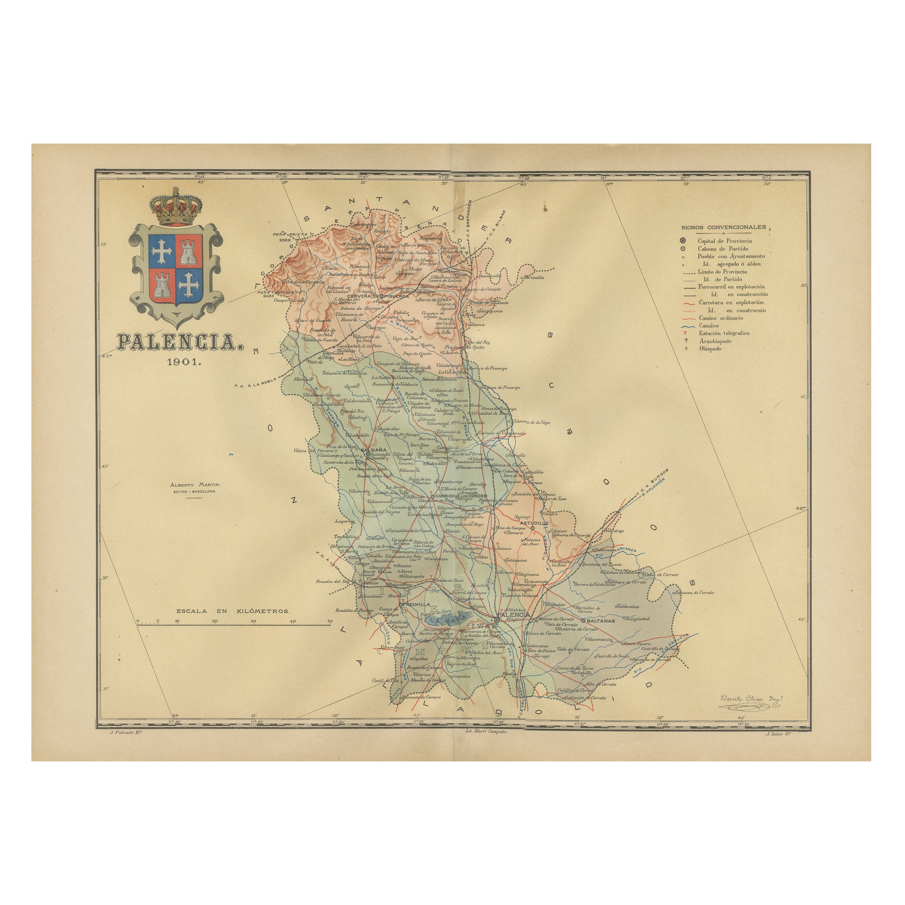
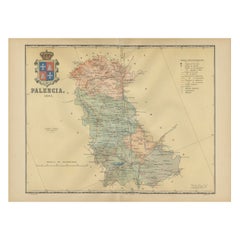
- Original Antique Map of Palencia Province, in Northern Spain, 1901Located in Langweer, NLThis historical map is of Palencia, a province in the northern part of Spain. Palencia is situated within the autonomous community of Castilla y León. It is bordered by the provinc...Category
Antique Early 1900s Maps
MaterialsPaper
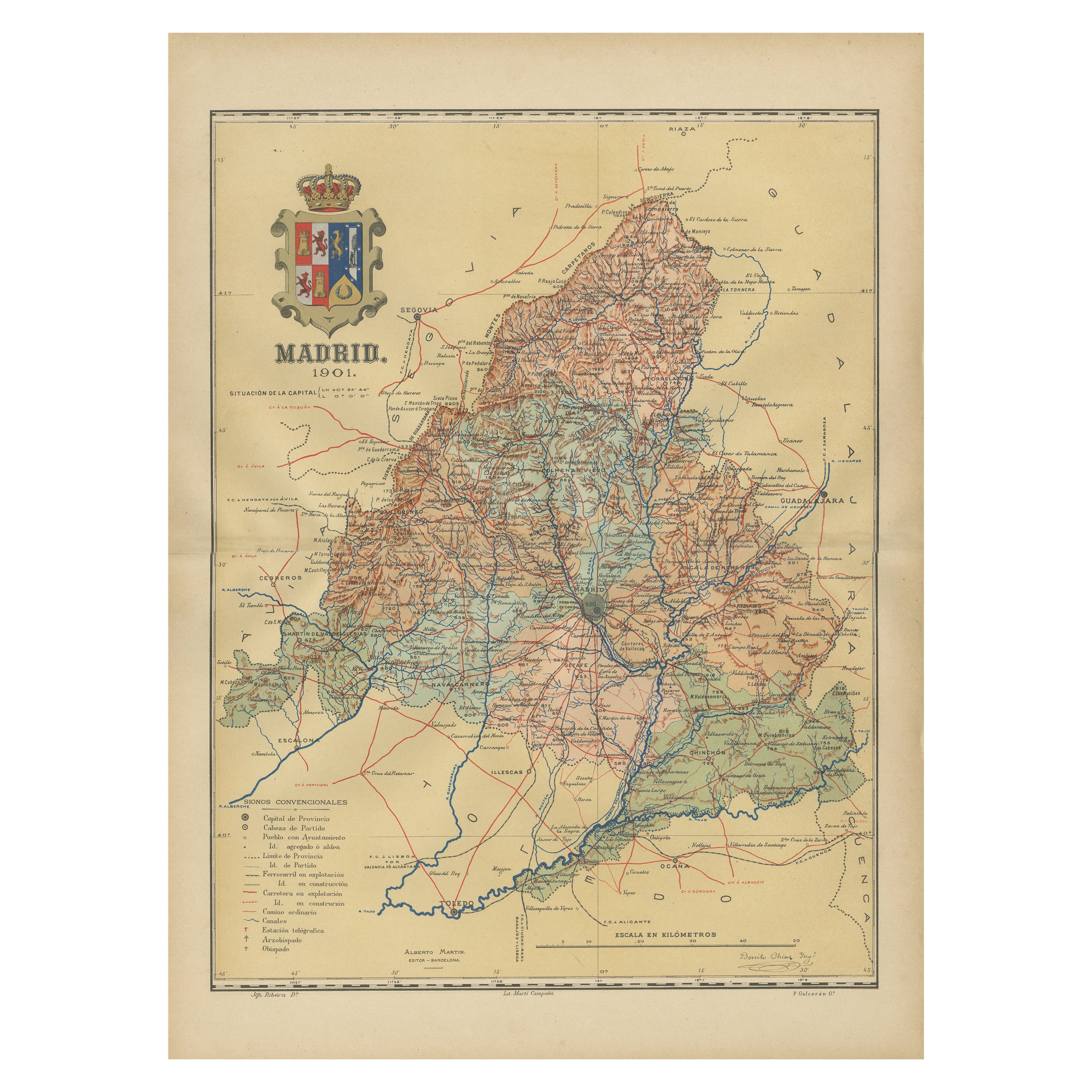
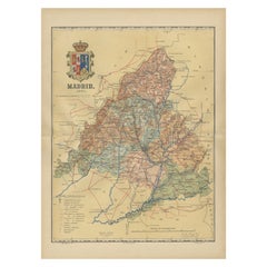
- Madrid 1901: A Historical Map of Spain's Capital ProvinceLocated in Langweer, NLThe map is of the province of Madrid, the capital region of Spain, as it appeared in 1901. Here are the key features it displays: The map shows the central part of Spain, with the Guadarrama mountain range prominently visible, marking the natural border to the north of Madrid. Blue lines likely indicate rivers, including the Manzanares River, which flows through Madrid, and the Jarama River, a tributary to the Tagus. Red lines depict the roads and railways, outlining the infrastructure that connects Madrid's various towns and cities within the province and beyond. Symbols and labels mark the locations of cities, towns, and villages, with Madrid itself likely being the focal point. Dotted lines may represent the administrative divisions within the province. The map includes a legend (Signos Convencionales) that explains the symbols used for provincial capitals, roads, railways, and other geographic features. The coat of arms of Madrid, featuring a bear and a strawberry tree (madroño), is prominently featured, symbolizing the city's and the province's historical coat of arms. About the province of Madrid: Madrid is not only the capital of Spain but also the heart of the Iberian Peninsula, both geographically and politically. The city is renowned for its rich repositories of European art, including the Prado Museum's works by Goya, Velázquez, and other Spanish masters. The province of Madrid is characterized by a blend of historical and modern elements, with a rich cultural life that includes theater, opera, and flamenco, as well as gastronomy that features a mix of traditional Spanish dishes and international cuisine...Category
Antique Early 1900s Maps
MaterialsPaper
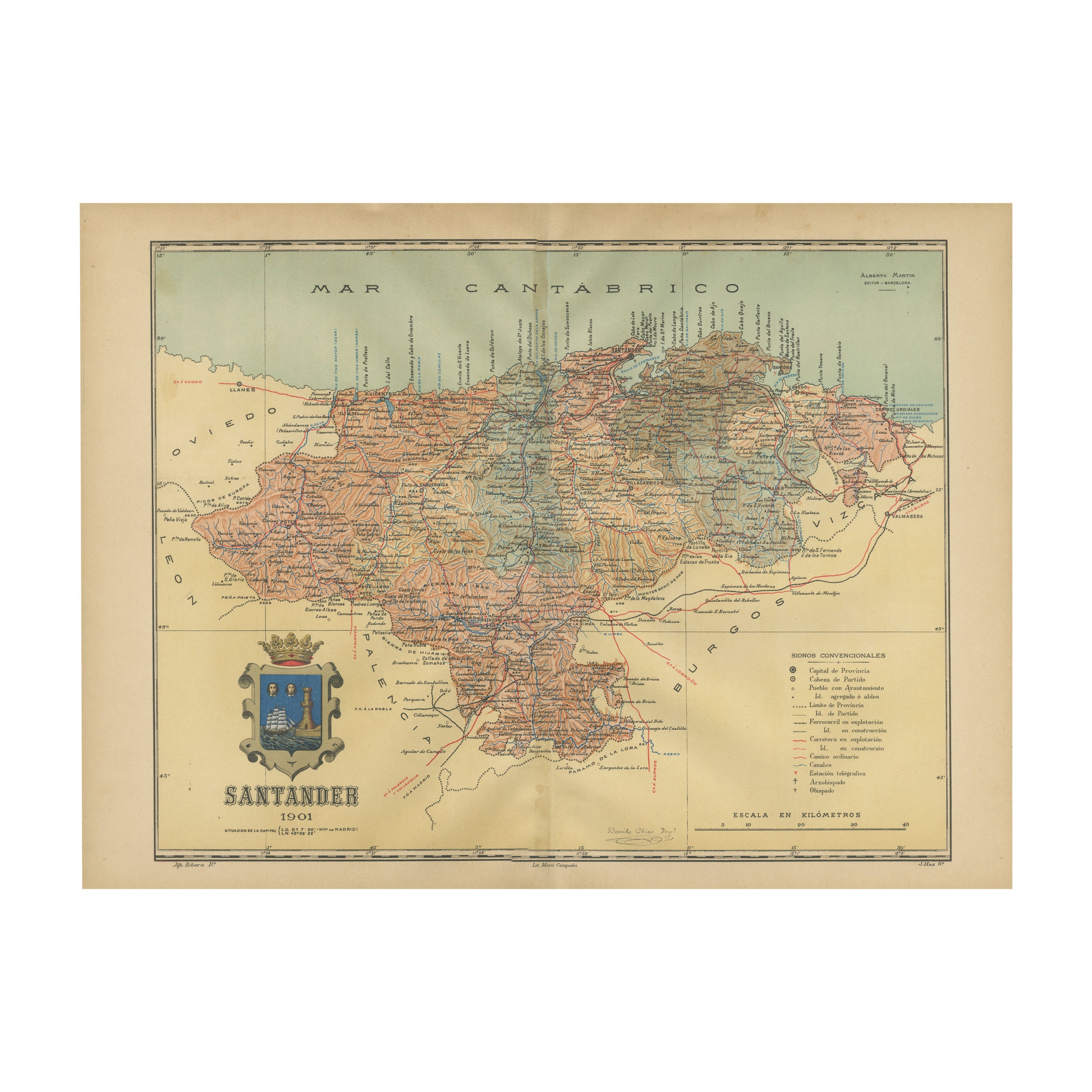
- Maritime and Terrestrial Survey of Spanish Santander in 1901, An Original MapLocated in Langweer, NLThis antique map is a historical map of the province of Santander (currently known as Cantabria) from the year 1901. Santander is located along the northern coast of Spain, bordering...Category
Antique Early 1900s Maps
MaterialsPaper
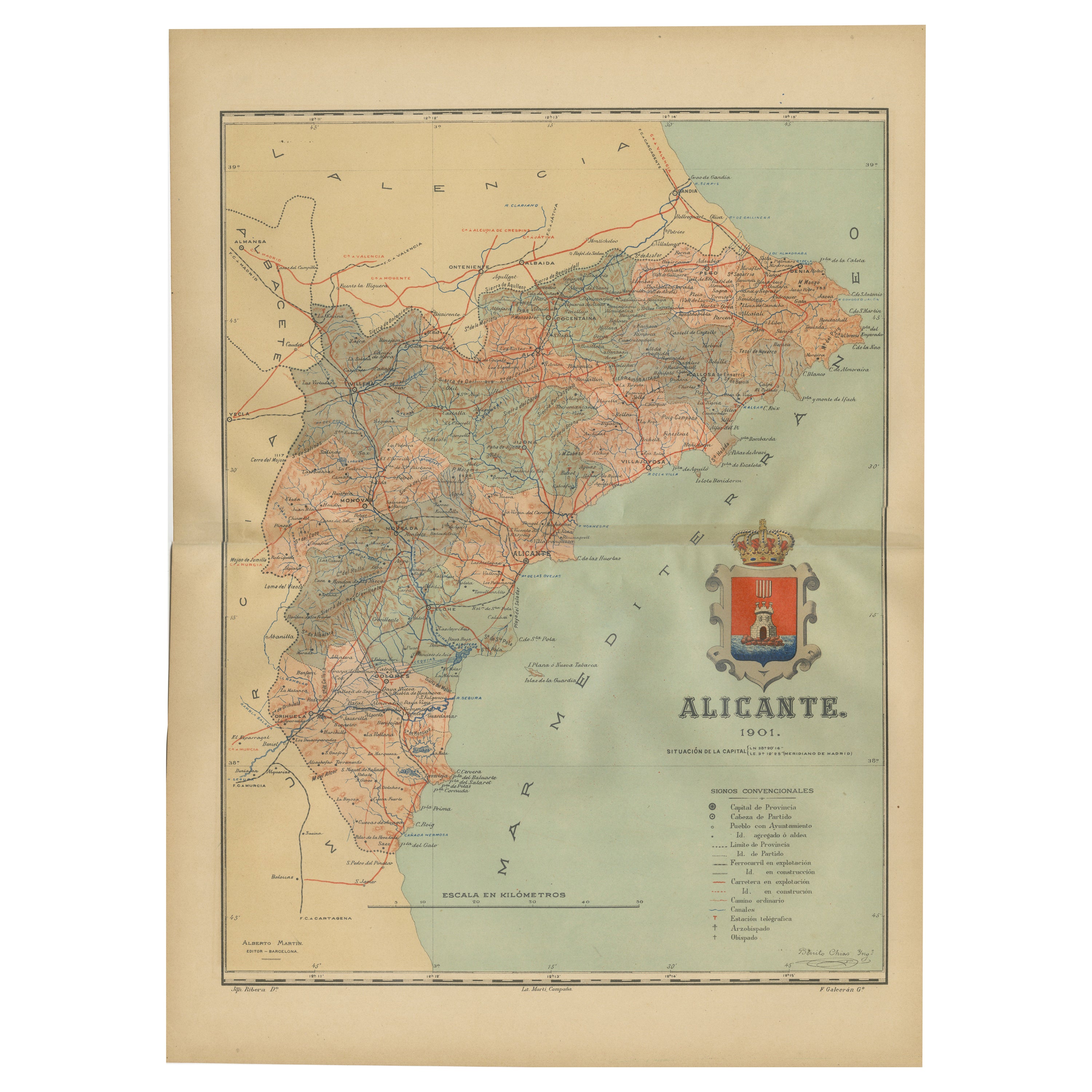
- Alicante in a 1901 Antique Map: Maritime Gateway of Spain's Costa BlancaLocated in Langweer, NLAn original antique map of the province of Alicante, dated 1901. It is part of the atlas series by D. Benito Chias y Carbo, featuring cartographic elements. Here are some characteri...Category
Antique Early 1900s Maps
MaterialsPaper
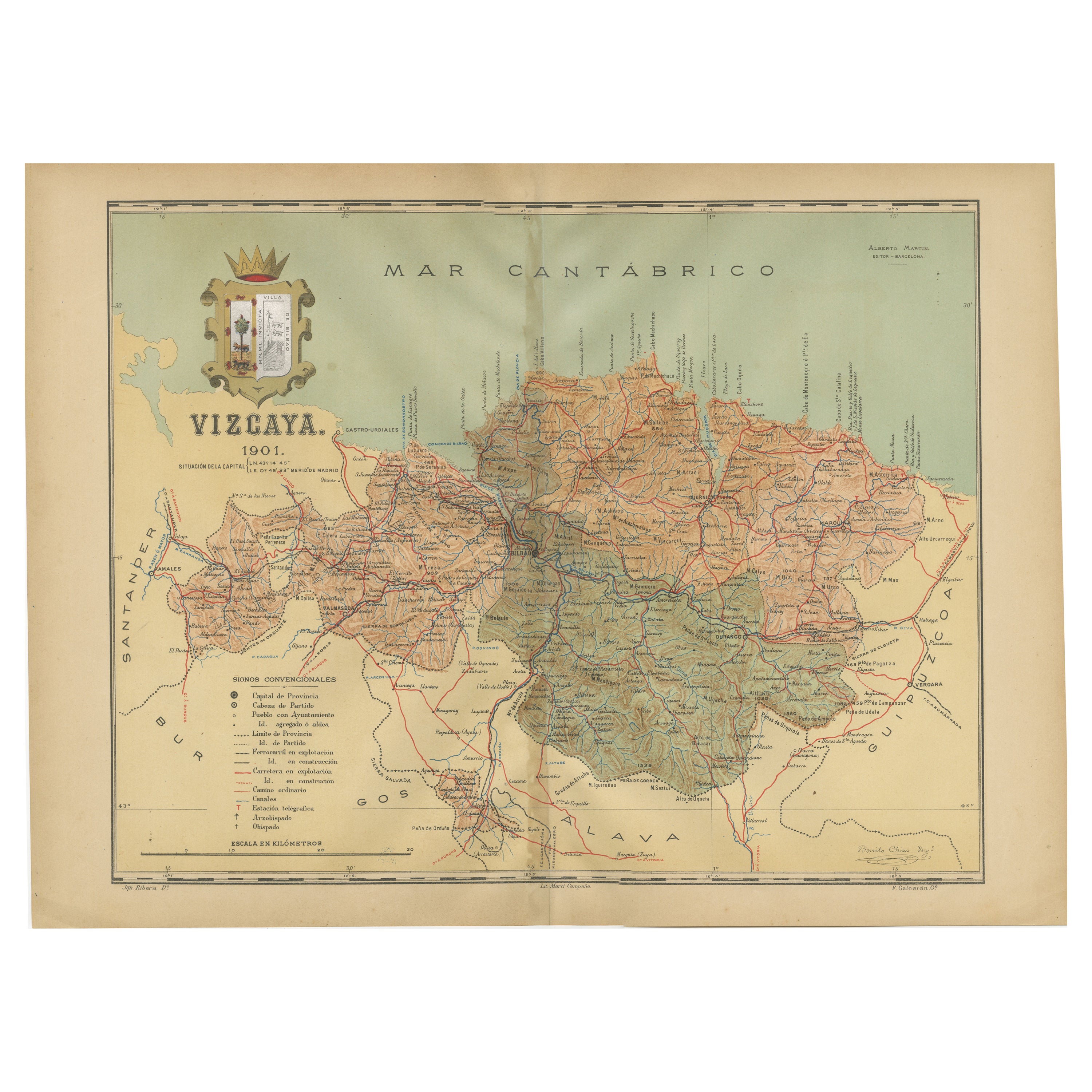
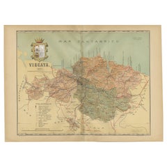
- Cartographic Heritage: The 1901 Map of the Vizcaya Province in SpainLocated in Langweer, NLThis is a historical map of the province of Vizcaya (Biscay) in Spain, dated 1901. The title on the map is "VIZCAYA. 1901." It shows the topographical details of the region with cont...Category
Antique Early 1900s Maps
MaterialsPaper
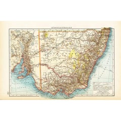
- German Antique Map of Southeastern Australia, 1904Located in Langweer, NLThis large antique map is taken from; 'Andrees Allgemeiner Handatlas in 126 Haupt-Und 139 Nebenkarten', Bielefeld; Leipzig: Velhagen & Klasing 1899. Andrees Allgemeiner Handatlas was...Category
20th Century Maps
MaterialsPaper


You May Also Like
- 17th Century Nicolas Visscher Map of Southeastern EuropeLocated in Hamilton, OntarioA beautiful, highly detailed map of southeastern Europe by Nicolas Visscher. Includes regions of Northern Italy (showing the cities Bologna, Padua, and Venice), Bohemia, Austria (sho...Category
Antique 17th Century Dutch Maps
MaterialsPaper
- 17th Century Hand-Colored Map of Southeastern England by Mercator and HondiusBy Gerard MercatorLocated in Alamo, CAA 17th century copperplate hand-colored map entitled "The Sixt Table of England" by Gerard Mercator and Jodocus Hondius, published in Amsterdam in 1635 in 'Cosmographicall Descriptio...Category
Antique Mid-17th Century Dutch Maps
MaterialsPaper
- Southeastern Ireland: A 17th Century Hand Colored Map by Mercator and HondiusBy Gerard MercatorLocated in Alamo, CAA 17th century copperplate hand-colored map entitled "The Second Table of Ireland, Udrone" by Gerard Mercator and Jodocus Hondius, published in Amsterdam in 1635 in 'Cosmographicall ...Category
Antique Mid-17th Century Dutch Maps
MaterialsPaper
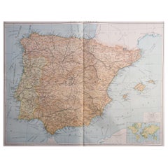
- Original Antique Map of Spain and Portugal, circa 1790Located in St Annes, LancashireSuper map of Spain and Portugal Copper plate engraving by A. Bell Published, circa 1790. Unframed.Category
Antique 1790s English Other Maps
MaterialsPaper
- Antique 1901 National Publishing Company's Road Map of New Jersey GeologicalLocated in Dayton, OHThe National Publishing Company's road map of New Jersey, showing all county and township divisions, cities villages and post-offices, railroads, ste...Category
Antique Early 1900s Victorian Prints
MaterialsPaper
- Large Original Vintage Map of Spain, circa 1920Located in St Annes, LancashireGreat map of Spain Original color. Good condition Published by Alexander Gross Unframed.Category
Vintage 1920s English Maps
MaterialsPaper


Recently Viewed
View AllMore Ways To Browse
Map Of Old Armenia
Teak Wood Sphere
Nova Guinea Maps
Antique Map Of Illinois
Petite Point Hand Bag
Antique Map Of Southeastern Us
Antique Map Alabama
Antique Map Of Sydney
Malay Archipelago Map
Fiji Map
Map Prussia Germany
Small Map
The Malay Archipelago
Bad Bentheim
Johannes Janssonius On Sale
Albania Map
Antique Map Argentina
Antique Map Of Argentina