Items Similar to Original Antique Map of Palencia Province, in Northern Spain, 1901


Want more images or videos?
Request additional images or videos from the seller
1 of 6
Original Antique Map of Palencia Province, in Northern Spain, 1901
About the Item
This historical map is of Palencia, a province in the northern part of Spain.
Palencia is situated within the autonomous community of Castilla y León. It is bordered by the provinces of León, Cantabria, Burgos, and Valladolid. The capital city is also called Palencia. It is known for its historical heritage, including the Gothic Cathedral (Palencia Cathedral), which is one of the largest in Europe. The province features a varied landscape with the fertile Tierra de Campos on the plains used primarily for agriculture, and to the north, the Cantabrian Mountains with the protected natural spaces.
Agriculture has traditionally been the mainstay of the province's economy, with crops such as wheat, barley, and sugar beets being prominent.
The Romanesque architecture is significant in Palencia, with the area along the Camino de Santiago pilgrimage route, especially the town of Carrión de los Condes, featuring notable churches and monasteries.
Palencia has natural reserves such as Fuentes Carrionas y Fuente Cobre-Montaña Palentina Natural Park, which provides a habitat for a variety of wildlife and is a destination for outdoor activities.
Palencia has several historical sites dating back to the Roman era and played a significant role during the Reconquista and in the later Middle Ages.
This province, like many others in Spain, is steeped in history and rich in cultural and natural attractions.
The province of Palencia is located in the northern part of Spain, within the autonomous community of Castile and León. It is characterized by a diverse landscape that includes part of the Cantabrian Mountains to the north and the expansive Castilian Plateau (Meseta Castellana) to the south. The province is home to a rich historical heritage, with numerous Romanesque churches, particularly in the city of Palencia, which is the capital and a significant urban center. The province is also known for its natural beauty, including the Natural Park of Fuentes Carrionas and Fuente Cobre-Montaña Palentina to the north.
- Dimensions:Height: 14.77 in (37.5 cm)Width: 20.08 in (51 cm)Depth: 0 in (0.02 mm)
- Materials and Techniques:
- Period:1900-1909
- Date of Manufacture:1901
- Condition:Good condition. Central vertical folding lines as issued. Aged paper with typically warm, yellowish-brown hue, especially around the edges. A light brown discoloring along the top of the fold. Check the images carefully.
- Seller Location:Langweer, NL
- Reference Number:
About the Seller
5.0
Platinum Seller
These expertly vetted sellers are 1stDibs' most experienced sellers and are rated highest by our customers.
Established in 2009
1stDibs seller since 2017
1,916 sales on 1stDibs
Typical response time: <1 hour
- ShippingRetrieving quote...Ships From: Langweer, Netherlands
- Return PolicyA return for this item may be initiated within 14 days of delivery.
More From This SellerView All
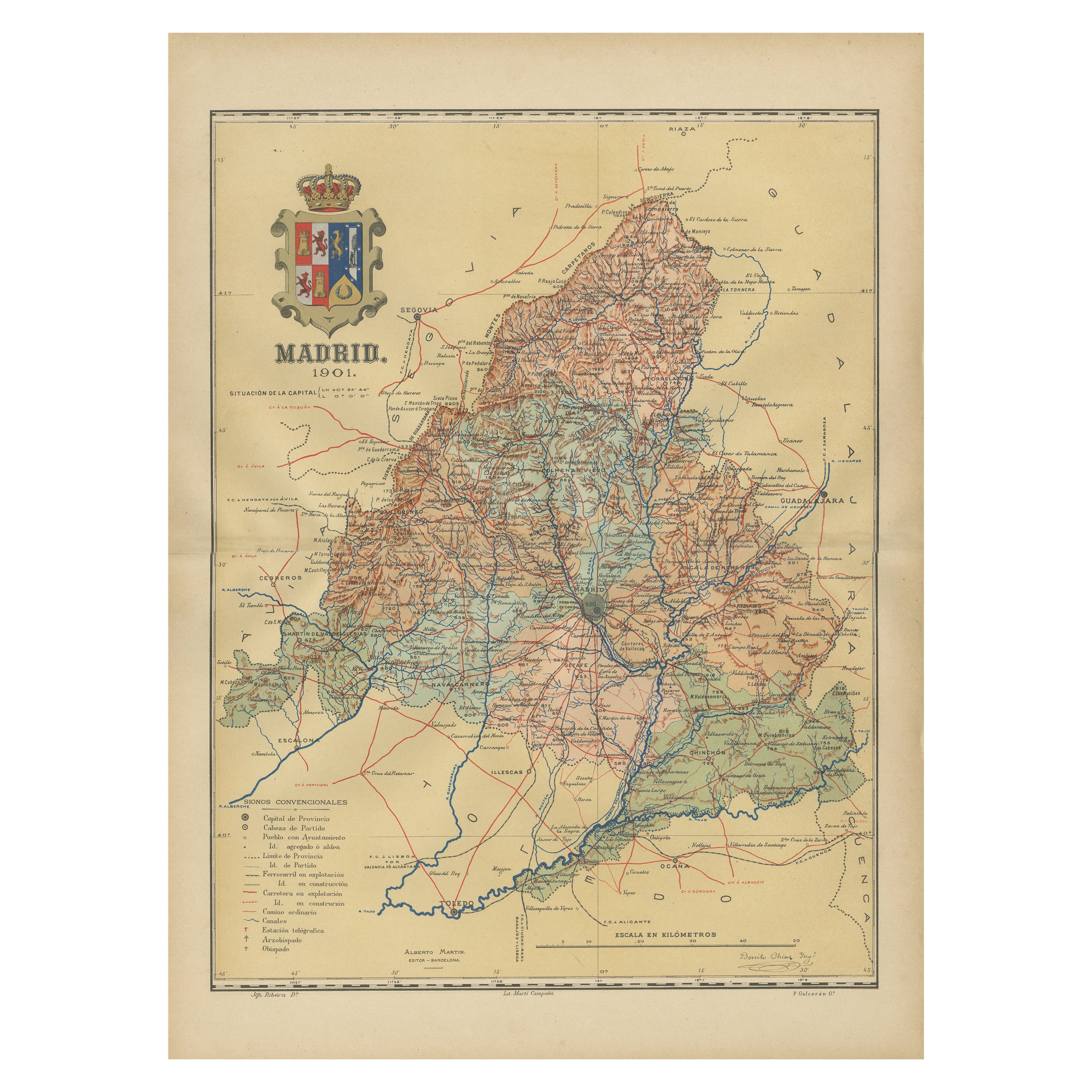
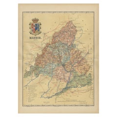
- Madrid 1901: A Historical Map of Spain's Capital ProvinceLocated in Langweer, NLThe map is of the province of Madrid, the capital region of Spain, as it appeared in 1901. Here are the key features it displays: The map shows the central part of Spain, with the Guadarrama mountain range prominently visible, marking the natural border to the north of Madrid. Blue lines likely indicate rivers, including the Manzanares River, which flows through Madrid, and the Jarama River, a tributary to the Tagus. Red lines depict the roads and railways, outlining the infrastructure that connects Madrid's various towns and cities within the province and beyond. Symbols and labels mark the locations of cities, towns, and villages, with Madrid itself likely being the focal point. Dotted lines may represent the administrative divisions within the province. The map includes a legend (Signos Convencionales) that explains the symbols used for provincial capitals, roads, railways, and other geographic features. The coat of arms of Madrid, featuring a bear and a strawberry tree (madroño), is prominently featured, symbolizing the city's and the province's historical coat of arms. About the province of Madrid: Madrid is not only the capital of Spain but also the heart of the Iberian Peninsula, both geographically and politically. The city is renowned for its rich repositories of European art, including the Prado Museum's works by Goya, Velázquez, and other Spanish masters. The province of Madrid is characterized by a blend of historical and modern elements, with a rich cultural life that includes theater, opera, and flamenco, as well as gastronomy that features a mix of traditional Spanish dishes and international cuisine...Category
Antique Early 1900s Maps
MaterialsPaper
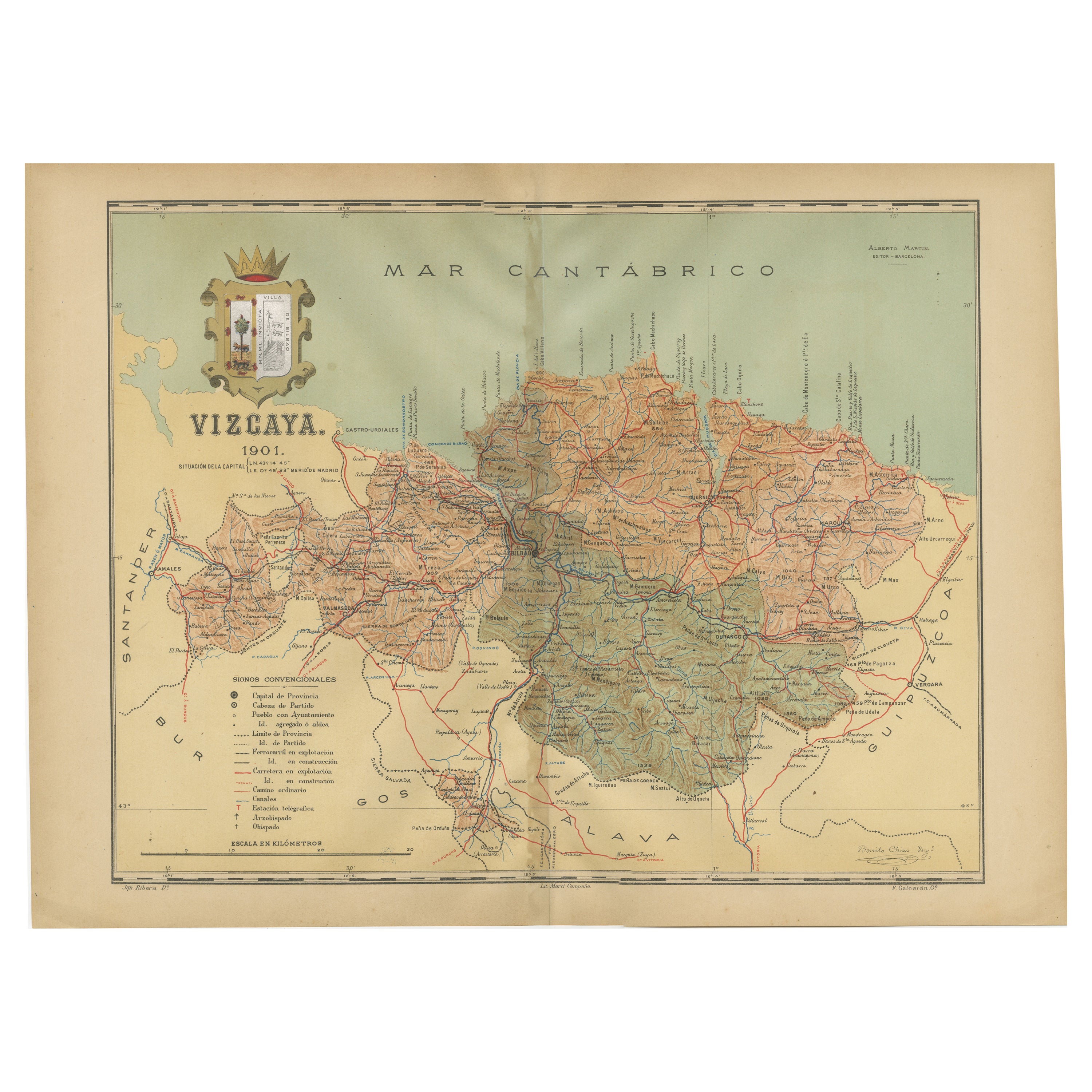
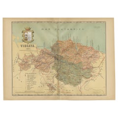
- Cartographic Heritage: The 1901 Map of the Vizcaya Province in SpainLocated in Langweer, NLThis is a historical map of the province of Vizcaya (Biscay) in Spain, dated 1901. The title on the map is "VIZCAYA. 1901." It shows the topographical details of the region with cont...Category
Antique Early 1900s Maps
MaterialsPaper
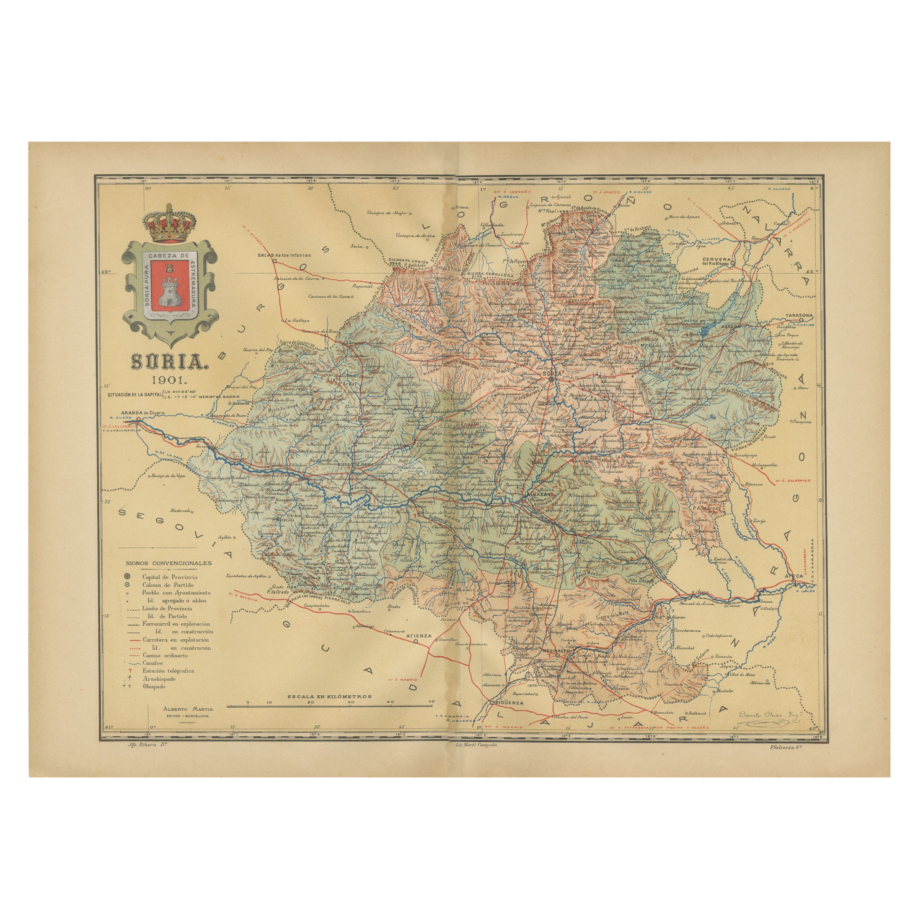
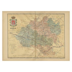
- Map of Soria Province, 1901: Detailed Cartography of Northeastern SpainLocated in Langweer, NLThe map is a historical map of the province of Soria from 1901. A decorative coat of arms enhances the aesthetic of the map, signifying the historical and cultural significance of ...Category
Antique Early 1900s Maps
MaterialsPaper
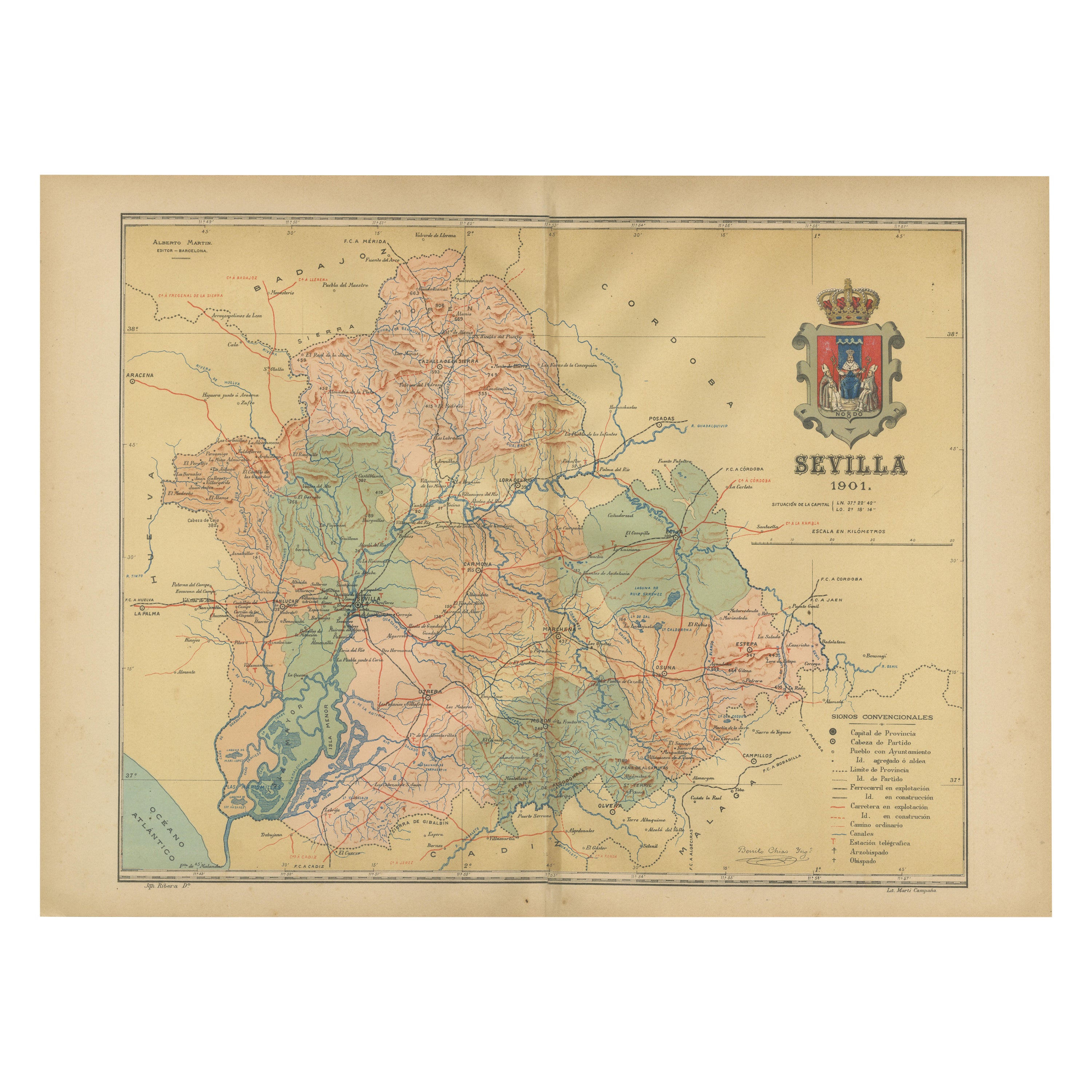
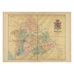
- Map of Sevilla Province, 1901: A Depiction of The Spanish Cultural HeartlandLocated in Langweer, NLThe print for sale here depicts a historical map of the province of Sevilla (Seville) from the year 1901. Sevilla is located in the southern part of Spain and is part of the autonomo...Category
Antique Early 1900s Maps
MaterialsPaper
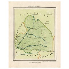
- Antique Map of The Province of Drenthe in the Northern Netherlands, 1865Located in Langweer, NLAntique map titled 'Provincie Drenthe'. Original antique map of Drenthe, the Netherlands. These scarse detailed maps of Dutch Towns originate from the 'Gemeente-atlas' of Jacob Kuype...Category
Antique 19th Century Maps
MaterialsPaper
- Original Antique Map of Northern IndiaBy Jakob van der SchleyLocated in Langweer, NLAntique map titled 'Carte de l'Indoustan (..) - Kaart van Hindoestan (..)'. Original antique map of northern India. This map originates from 'His...Category
Antique Mid-18th Century Maps
MaterialsPaper

You May Also Like
- Original Antique Map of Spain and Portugal, circa 1790Located in St Annes, LancashireSuper map of Spain and Portugal Copper plate engraving by A. Bell Published, circa 1790. Unframed.Category
Antique 1790s English Other Maps
MaterialsPaper
- Original Antique Map of Spain and Portugal by Thomas Clerk, 1817Located in St Annes, LancashireGreat map of Spain and Portugal Copper-plate engraving Drawn and engraved by Thomas Clerk, Edinburgh. Published by Mackenzie And Dent, 1817 Unframed.Category
Antique 1810s English Maps
MaterialsPaper
- Original Antique Map of Spain and Portugal, Engraved By Barlow, 1806Located in St Annes, LancashireGreat map of Spain And Portugal Copper-plate engraving by Barlow Published by Brightly & Kinnersly, Bungay, Suffolk. 1806 Unframed.Category
Antique Early 1800s English Maps
MaterialsPaper
- Antique 18th Century Map of the Province of Pensilvania 'Pennsylvania State'Located in Philadelphia, PAA fine antique of the colony of Pennsylvania. Noted at the top of the sheet as a 'Map of the province of Pensilvania'. This undated and anonymous map is thought to be from the Gentleman's Magazine, London, circa 1775, although the general appearance could date it to the 1760's. The southern boundary reflects the Mason-Dixon survey (1768), the western boundary is placed just west of Pittsburgh, and the northern boundary is not marked. The map has a number of reference points that likely refer to companion text and appear to be connected to boundaries. The western and southern boundaries are marked Q, R, S, for example. A diagonal line runs from the Susquehanna R to the Lake Erie P. A broken line marked by many letters A, B, N, O, etc., appears in the east. There are no latitude or longitude markings, blank verso. Framed in a shaped contemporary gilt wooden frame and matted under a cream colored matte. Bearing an old Graham Arader Gallery...Category
Antique 18th Century British American Colonial Maps
MaterialsPaper
- Large Original Vintage Map of Spain, circa 1920Located in St Annes, LancashireGreat map of Spain Original color. Good condition Published by Alexander Gross Unframed.Category
Vintage 1920s English Maps
MaterialsPaper
- Antique 1901 National Publishing Company's Road Map of New Jersey GeologicalLocated in Dayton, OHThe National Publishing Company's road map of New Jersey, showing all county and township divisions, cities villages and post-offices, railroads, ste...Category
Antique Early 1900s Victorian Prints
MaterialsPaper


Recently Viewed
View AllMore Ways To Browse
Map Of Old Armenia
Teak Wood Sphere
Nova Guinea Maps
Antique Map Of Illinois
Petite Point Hand Bag
Antique Map Of Southeastern Us
Antique Map Alabama
Antique Map Of Sydney
Malay Archipelago Map
Gambia Antique Map
Uruguay Antique Map
Guyana Antique Map
Ruscelli Map
Masque Theatre No
Nova Scotia Map
Antique Map Tuscany
Berkshire Antique Map
Cornwall Map