Items Similar to 1856 U.S. Coast Survey Map of Chesapeake Bay and Delaware Bay
Want more images or videos?
Request additional images or videos from the seller
1 of 9
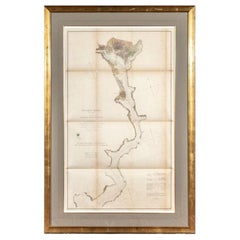
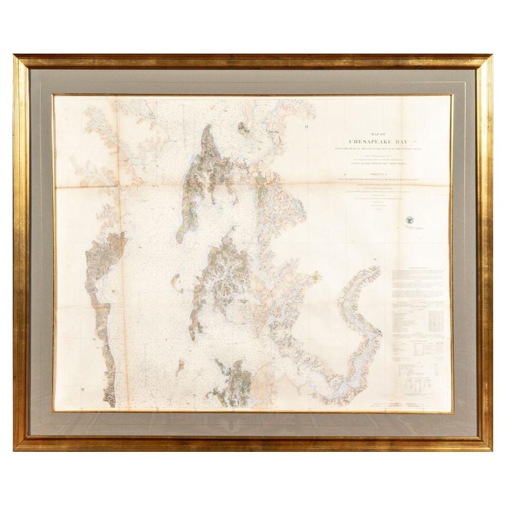
1856 U.S. Coast Survey Map of Chesapeake Bay and Delaware Bay
About the Item
Presented is U.S. Coast Survey nautical chart or maritime map of Chesapeake Bay and Delaware Bay from 1856. The map depicts the region from Susquehanna, Maryland to the northern Outer Banks in North Carolina. It also shows from Richmond and Petersburg, Virginia to the Atlantic Ocean. The map is highly detailed with many cities and towns labeled throughout. Rivers, inlets, and bays are also labeled. Various charts illustrating more specific parts of the region are marked on the map using dotted lines. The lines form boxes, and the corresponding chart number and publication date are given. Extensive triangulation surveys were conducted the length of Chesapeake Bay and are illustrated here. Hampton Roads, Virginia is labeled, along with the James, York, and Rappahannock Rivers, which were all extensively surveyed.
The chart was published under the supervision of A. D. Bache, one of the most influential and prolific figures in the early history of the U.S. Coast Survey, for the 1856 Report of the Superintendent of the U.S. Coast Survey. Alexander Dallas Bache (1806-1867) was an American physicist, scientist, and surveyor. Bache served as the Superintendent of the U.S. Coast Survey from 1843 to 1865. Born in Philadelphia, Bache toured Europe and composed an important treatise on European Education. He also served as president of Philadelphia's Central High School and was a professor of natural history and chemistry at the University of Pennsylvania. Upon the death of Ferdinand Rudolph Hassler, Bache was appointed Superintendent of the United States Coast Survey.
The Office of the Coast Survey, founded in 1807 by President Thomas Jefferson and Secretary of Commerce Albert Gallatin, is the oldest scientific organization in the U.S. Federal Government. Jefferson created the "Survey of the Coast," as it was then called, in response to a need for accurate navigational charts of the new nation's coasts and harbors. Today, the Coast Survey is part of the National Oceanic and Atmospheric Administration or NOAA as the National Geodetic Survey.
CONDITION:
Very good. Backed on archival tissue for stability. Light wear along original fold lines. Blank on verso. Framed according to the highest conservation standards in an antiqued silver frame with UV glass. Framed Dimensions: 39 3/4" H x 28" W x 1" D.
- Creator:United States Coastal Survey (Author)
- Dimensions:Height: 39.75 in (100.97 cm)Width: 28 in (71.12 cm)Depth: 1 in (2.54 cm)
- Materials and Techniques:
- Place of Origin:
- Period:
- Date of Manufacture:1856
- Condition:Additions or alterations made to the original: Framed by Artifacts Archival Framing in Alexandria, Virginia, in 2018. Repaired: Backed on archival tissue for stability. Wear consistent with age and use.
- Seller Location:Colorado Springs, CO
- Reference Number:
About the Seller
4.9
Platinum Seller
These expertly vetted sellers are 1stDibs' most experienced sellers and are rated highest by our customers.
Established in 2010
1stDibs seller since 2011
400 sales on 1stDibs
Typical response time: <1 hour
- ShippingRetrieving quote...Ships From: Colorado Springs, CO
- Return PolicyA return for this item may be initiated within 10 days of delivery.
More From This SellerView All
- 1812 United States Map, by Pierre Tardieu, Antique French Map Depicting the U.S.By Pierre François TardieuLocated in Colorado Springs, CO1812 "United States of Nth America -- Carte des Etats-Unis De L'Amerique Septentrionale" Two-Sheet Map by Tardieu This attractive map, published in Paris in 1812, is one of the most rare large format maps from the period. It features a view of the East Coast of the U.S. from Maryland to just below South Carolina. Additionally, Ellicott’s plan for the City of Washington D.C. is included at the top right and an illustration of Niagara Falls is shown at the bottom right with a description in both French and English. This extremely detailed map not only depicts the mountainous regions of the southeastern U.S., but also includes names of regions, rivers, and towns. Based on the first state of Arrowsmith’s 4-sheet map of the United States, this map is completely engraved by Tardieu in Paris and showcases high quality engravings. This detailed map of the recently independent United States includes one of the largest and earliest examples of the Ellicott plan of Washington DC. The artist, Pierre François Tardieu (PF Tardieu) was a very well-known map engraver, geographer, and illustrator. Awarded a bronze medal by King Louis-Phillipe for the accuracy and beauty of his map-making, Tardieu produced many fine works including maps of Louisiana...Category
Antique 1810s French Maps
MaterialsPaper
- 1854 Map of Massachusetts, Connecticut and Rhode Island, Antique Wall MapLocated in Colorado Springs, COThis striking wall map was published in 1854 by Ensign, Bridgman & Fanning and has both full original hand-coloring and original hardware. This impression is both informative and highly decorative. The states are divided into counties, outlined in red, green, and black, and subdivided into towns. Roads, canals, and railroad lines are prominently depicted, although they are not all labeled. The mapmakers also marked lighthouses, banks, churches, and prominent buildings, with a key at right. The map is an informative and comprehensive overview of the infrastructural development of New England prior to the Civil War. Physical geographies depicted include elevation, conveyed with hachure marks, rivers and lakes. The impression features an inset map of Boston...Category
Antique 19th Century American Maps
MaterialsPaper
- 1861 Topographical Map of the District of Columbia, by Boschke, Antique MapLocated in Colorado Springs, COPresented is an original map of Albert Boschke's extremely sought-after "Topographical Map of the District of Columbia Surveyed in the Years 1856 ...Category
Antique 1860s American Historical Memorabilia
MaterialsPaper
- 1907 Map of Colorado, Antique Topographical Map, by Louis NellLocated in Colorado Springs, COThis highly detailed pocket map is a topographical map of the state of Colorado by Louis Nell from 1907. The map "has been complied from all availabl...Category
Antique Early 1900s American Maps
MaterialsPaper
- "Clason's Guide Map of Montana" by The Clason Map Company, Circa 1920sLocated in Colorado Springs, COPresented is “Clason's Guide Map of Montana,” published in the early 1920s by the Clason Map Company. Issued as a folding map, this map identifies county boundaries, county seats, Na...Category
Vintage 1920s American Art Deco Maps
MaterialsPaper
- Pictorial Map of Chicago, circa 1926Located in Colorado Springs, COThis is a colorful folding pocket map of the city of Chicago, published by The Clason Map Co., circa 1926. This highly decorative, double sided map features "Pictorial Map of Chicago...Category
Vintage 1920s American Maps
MaterialsPaper


You May Also Like
- Large Custom Framed 1857 U.S. Coast Survey of the Chesapeake BayLocated in Bridgeport, CTAn antique 1850's nautical map with hand-painted color accents entitled “Chesapeake Bay; Sheet no. 2: Head of the Bay to the Mouth of the Potomac River”....Category
Antique 1850s American American Classical Maps
MaterialsPaper
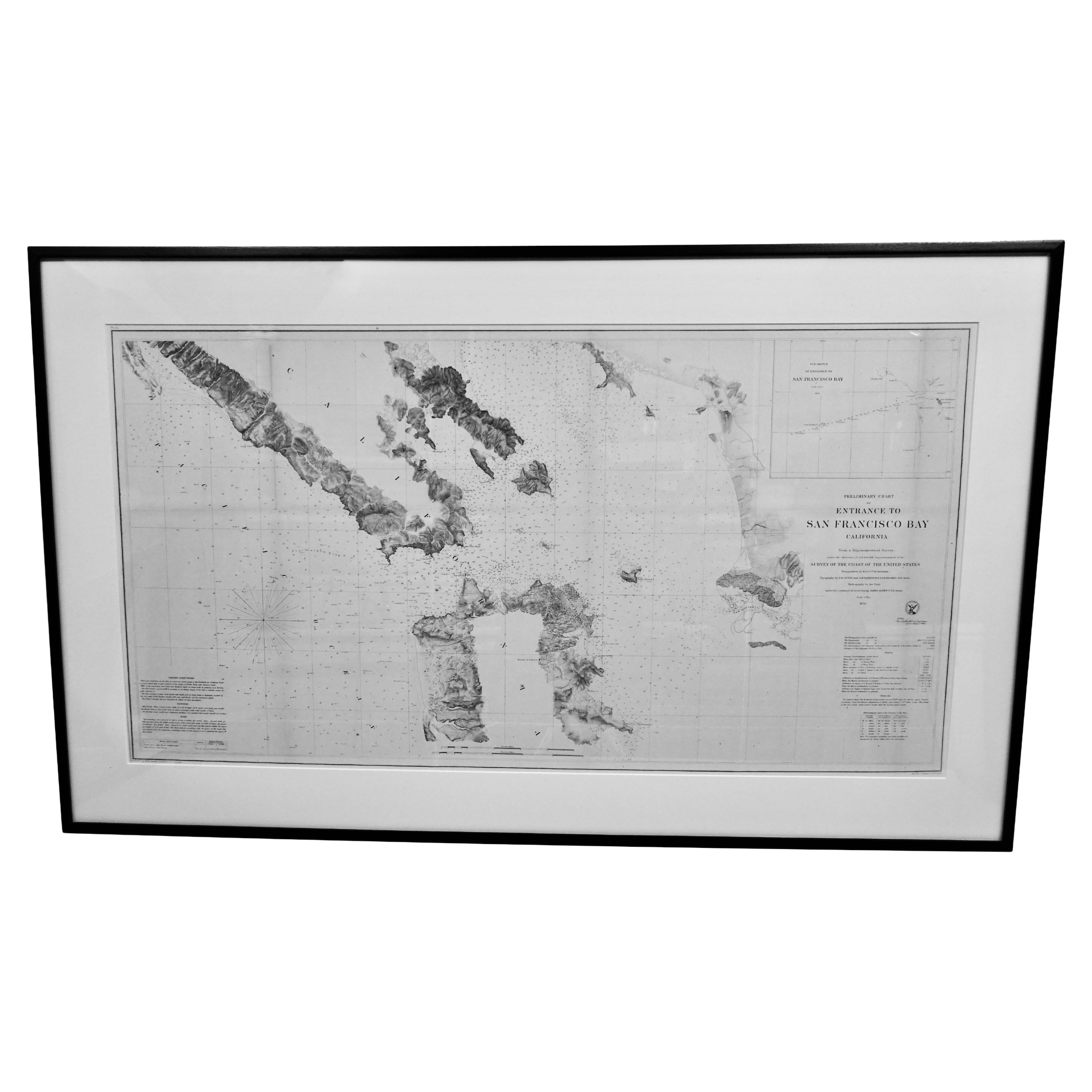
- Scarce U.S. Coast Survey Map Depicting Entrance to San Francisco Bay Dated 1856Located in San Francisco, CAA fine example of the 1856 U.S. Coast lithographic survey nautical chart of the entrance to San Francisco bay and the city. Published in 1856 by the Office of the Coast Survey the of...Category
Antique Mid-19th Century American Maps
MaterialsPaper
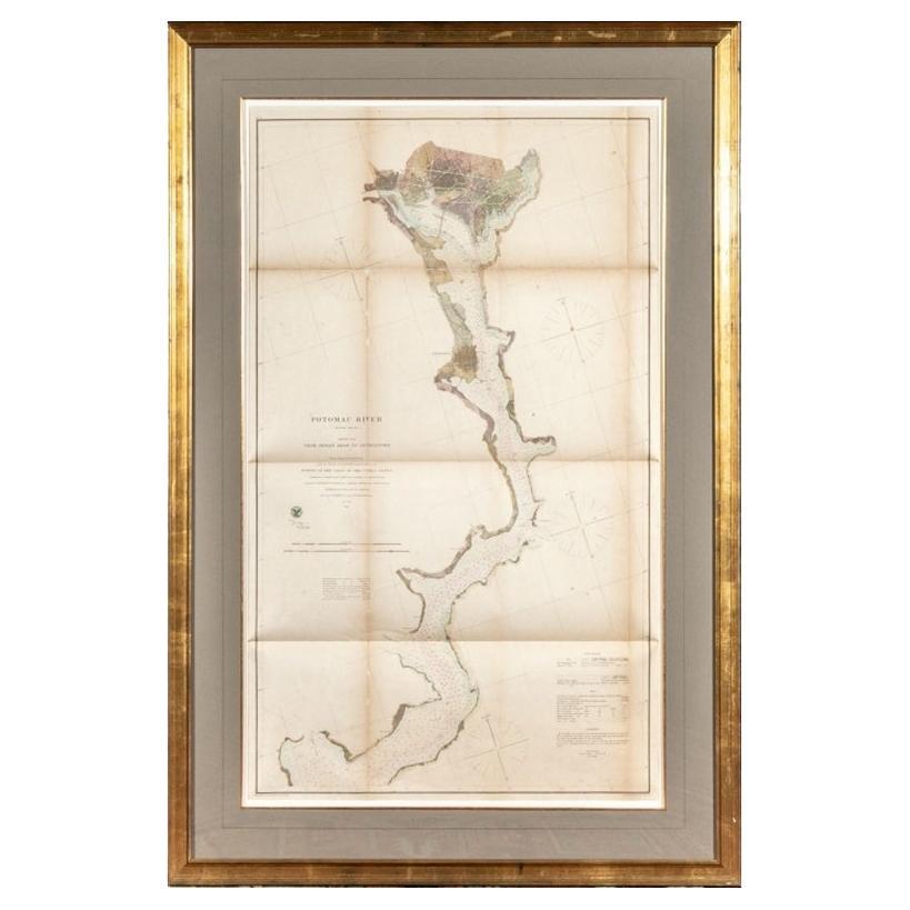
- 1864 U.S. Coast Survey of the Potomac River, from Indian Head to GeorgetownLocated in Bridgeport, CTAn antique nautical map with hand-painted color accents entitled "Potomac River (in four sheets): Sheet no. 4, from Indian Head to Georgetown". Created b...Category
Antique 19th Century American Classical Maps
MaterialsPaper
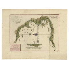
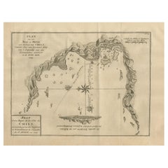
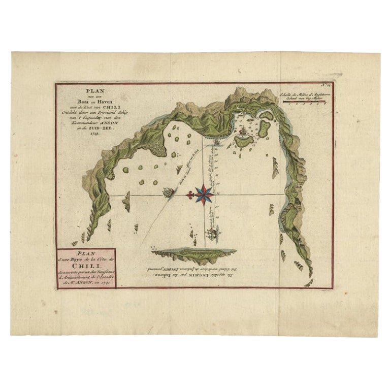
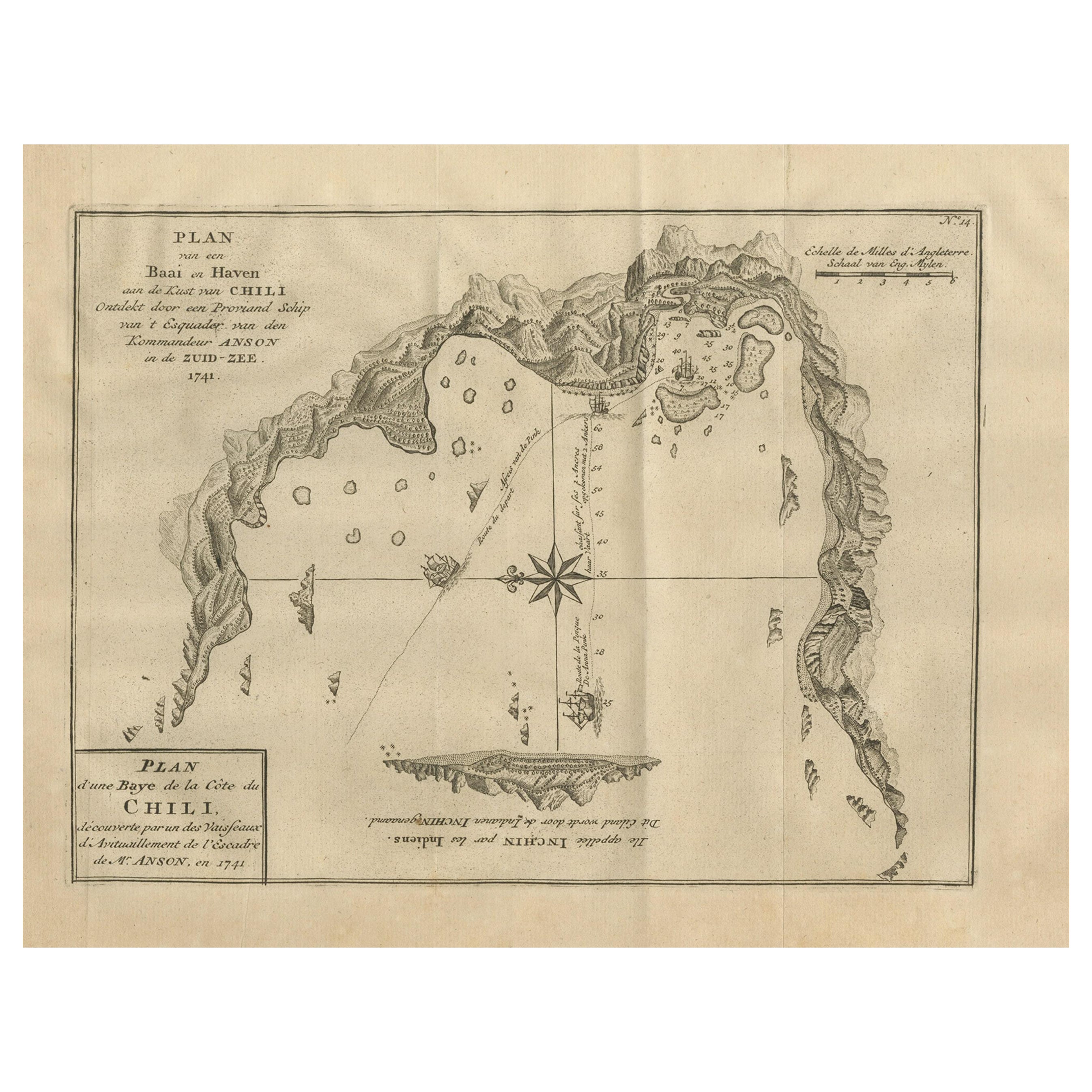
- Antique Map of a Bay on the Coast of Chile by Anson, 1749Located in Langweer, NLAntique map titled 'Plan van een Baai en Haven aan de Kust van Chili (..) - Plan d'une Baye de la Côte du Chili (..)'. Original antique map of a bay on the coast of Chile discovered ...Category
Antique 18th Century Maps
MaterialsPaper
- Antique Map of a Bay on the Coast of Chile, South America, c.1749Located in Langweer, NLAntique map titled 'Plan van een Baai en Haven aan de Kust van Chili (..) - Plan d'une Baye de la Côte du Chili (..)'. Original antique map of a bay on the coast of Chile discovered ...Category
Antique 18th Century Maps
MaterialsPaper
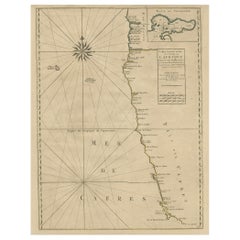
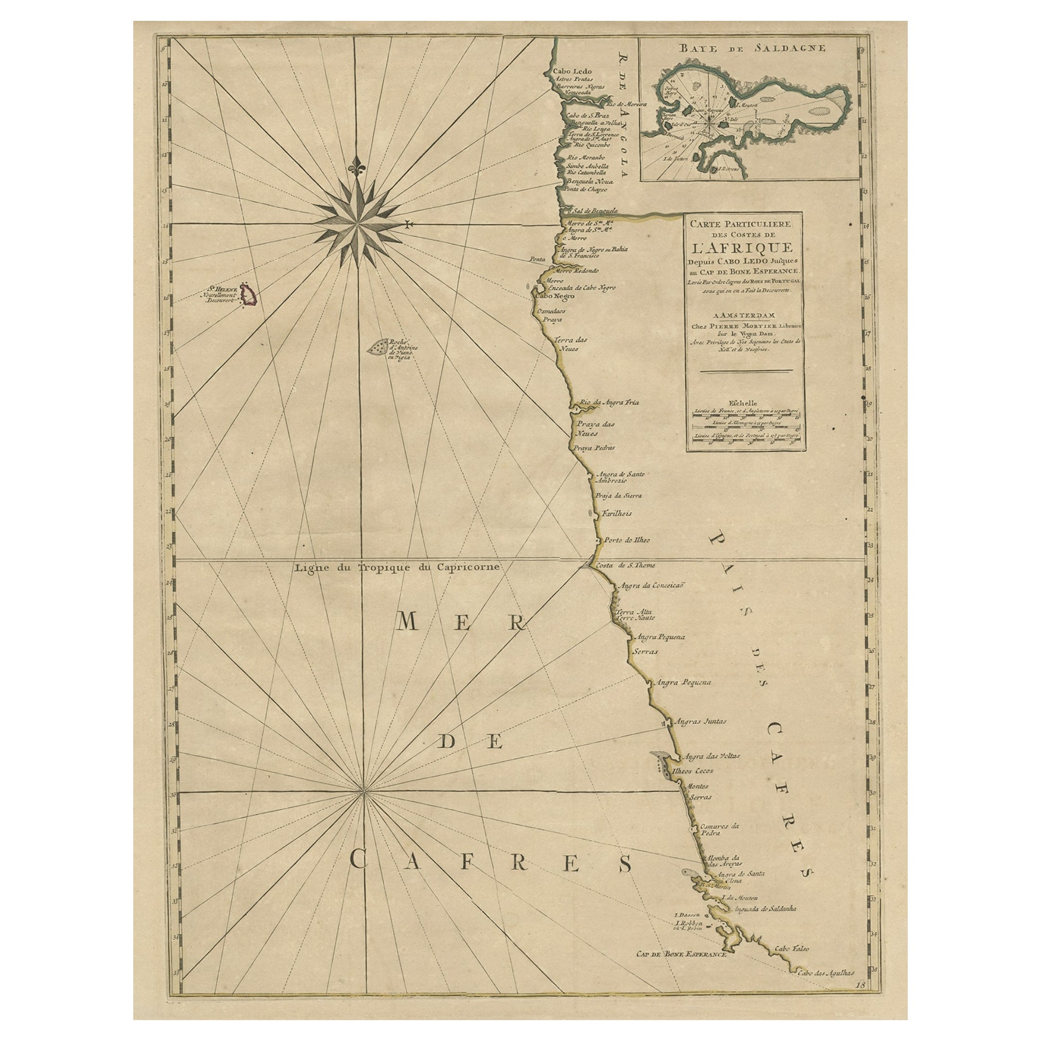
- Old Map of the Namibia and South Africa Coasts & Inset of Saldanha Bay, ca.1700Located in Langweer, NLAntique map titled 'Carte particuliere des Costes de l'Afrique'. Map of the coasts of Namibia and South Africa. With an inset map of Saldanha Bay. Artists and Engravers: Publ...Category
Antique Early 1700s Maps
MaterialsPaper