Items Similar to Antique Map of the Malay Archipelago with Images of Indigenous People, 1851

Want more images or videos?
Request additional images or videos from the seller
1 of 7
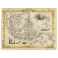
Antique Map of the Malay Archipelago with Images of Indigenous People, 1851
About the Item
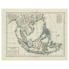
John Tallis & Company, often simply known as Tallis, was renowned for the production of maps and illustrated geographical publications in the mid-19th century. Tallis maps, such as the one of Indonesia, are characterized by their meticulous detail, elaborate borders, and unique vignettes that offer a glimpse into the cultural and geographical context of the region depicted.
The map of Indonesia would have been part of Tallis's "The British Colonies" series, which was accompanied by the descriptive text of Robert Montgomery Martin. This series is a reflection of the Victorian era's fascination with the expanding British Empire and its dominions overseas.
The map itself would feature the archipelago known as Indonesia today, but at the time of the map's creation, the region was known as the Dutch East Indies, a collection of Dutch colonial territories. The map likely delineates various islands, straits, and important cities, emphasizing the strategic and economic significance of the archipelago.
The vignettes on a Tallis map serve as an illustrative guide to the local customs, notable landscapes, wildlife, and historical buildings, enriching the cartographic information with visual narratives that catered to the interests and imaginations of the British public.
Tallis's maps are more than just navigational aids; they are visual historical records that reflect the period's colonial mindset and artistic preferences. They represent the cultural and political ethos of an era when Britain was actively expanding and consolidating its global colonial reach. Today, these maps are valued for both their artistic merit and their historical significance, offering insights into the perception and representation of British colonies in the 19th century.
More in detail:
The images or insets on the map appear to be detailed illustrations typical of the Tallis style, providing cultural and geographical context to the regions depicted. Here's a description of each one:
1. **Natives of New Guinea**: This inset likely depicts indigenous people of New Guinea, showing their traditional attire and weapons. Such images were meant to convey the appearance and culture of the inhabitants to a 19th-century audience unfamiliar with the region.
2. **The second image is "The Bee Bear." This would refer to a Binturong, also known as a bearcat, which is a viverrid native to South and Southeast Asia. It is not a bear but gets its name from its bear-like appearance and its fondness for eating honey (bee). This animal is known for its thick fur and prehensile tail, and it is one of the few mammals that has a fully prehensile tail. It's a nocturnal creature, and the illustration likely aims to depict one of the unique species found in the Indonesian archipelago.
3. **Scene Near Sarawak, Borneo**: A peaceful coastal scene, perhaps illustrating a settlement or village in the vicinity of Sarawak, which is now part of Malaysia on the island of Borneo. This would highlight the local geography and settlement patterns.
4. **Victoria Mount, New Guinea**: Featuring a mountainous landscape with a traditional sailing vessel in the foreground, this inset captures the rugged terrain of New Guinea and provides a sense of the maritime culture of the region.
These insets serve as a visual encyclopedia of sorts, offering snapshots of life and nature in the region. They would have provided 19th-century audiences with an exotic glimpse of far-off lands, serving both educational and decorative purposes.
- Dimensions:Height: 10.71 in (27.2 cm)Width: 14.26 in (36.2 cm)Depth: 0 in (0.02 mm)
- Materials and Techniques:
- Period:
- Date of Manufacture:1851
- Condition:Good given age. Original fold in middle as published. General age-related toning, please study scan carefully.
- Seller Location:Langweer, NL
- Reference Number:
About the Seller
5.0
Platinum Seller
These expertly vetted sellers are 1stDibs' most experienced sellers and are rated highest by our customers.
Established in 2009
1stDibs seller since 2017
1,928 sales on 1stDibs
Typical response time: <1 hour
- ShippingRetrieving quote...Ships From: Langweer, Netherlands
- Return PolicyA return for this item may be initiated within 14 days of delivery.
More From This SellerView All
- Decorative Antique Map of the Malay Archipelago or East Indies Island, 1851Located in Langweer, NLAntique map Indonesia titled 'Malay Archipelago, or East India Islands'. With vignettes of Victoria Mount, New Guinea, Nativaes of New Guinea an...Category
Antique 1850s Maps
MaterialsPaper
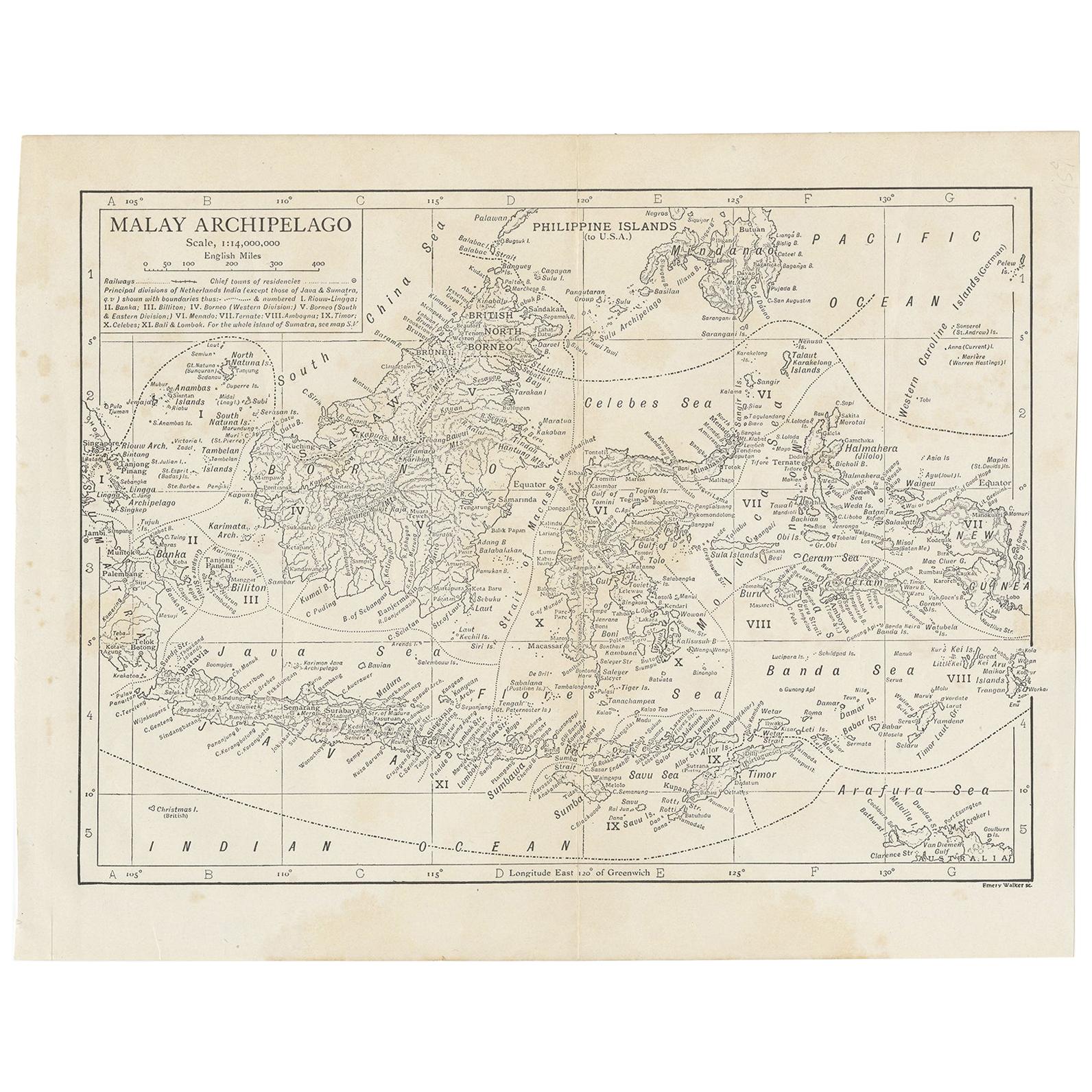
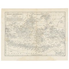
- Antique Map of the Malay Archipelago by Walker, 1911Located in Langweer, NLAntique map titled 'Malay Archipelago'. Old map of the Malay Archipelago including Borneo, Celebes, New Guinea, Java, Timor and others. This map ...Category
Early 20th Century Maps
MaterialsPaper
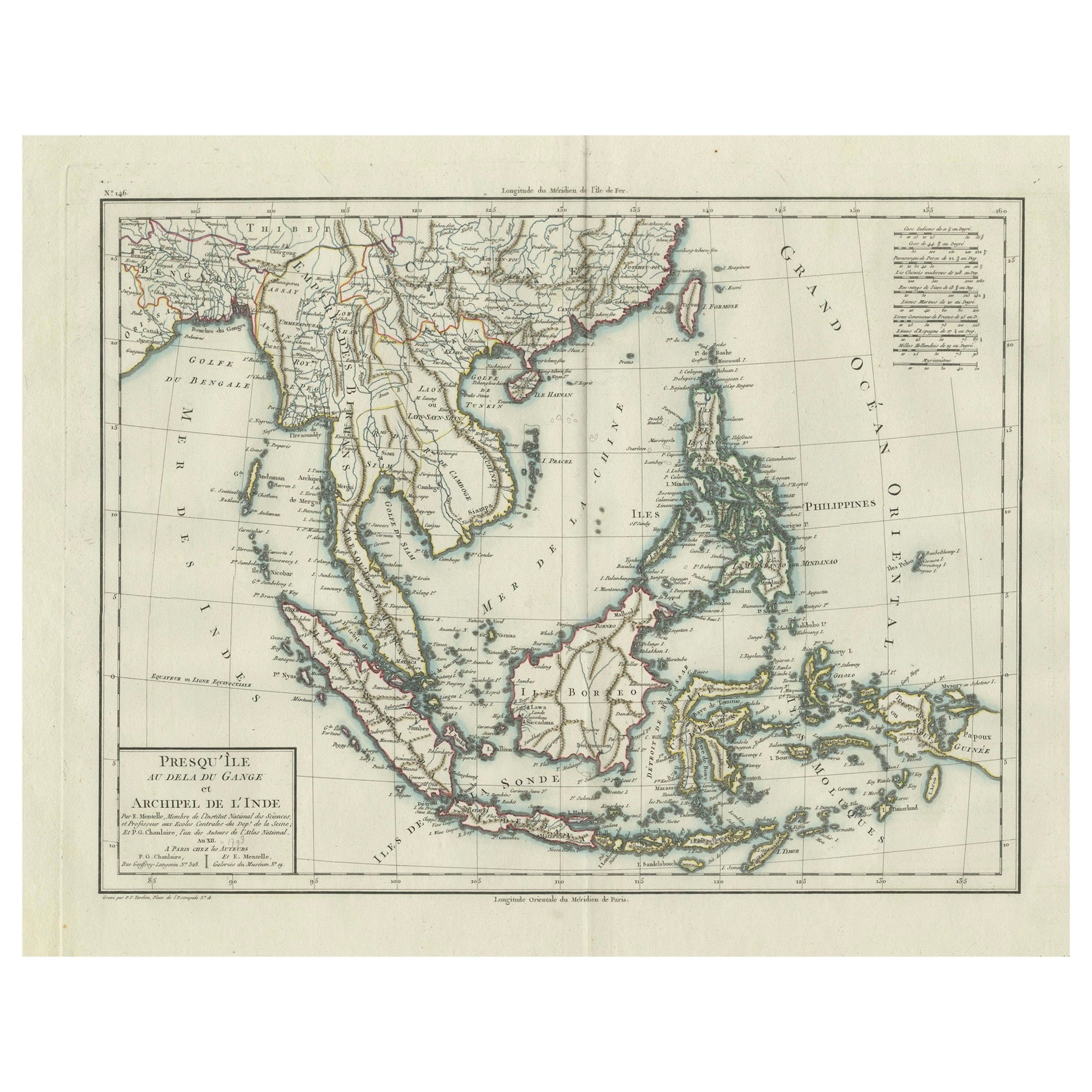
- 1797 Tardieu Map of Southeast Asia: The Malay Archipelago and BeyondLocated in Langweer, NLAn original historical map titled 'Presqu' Île Au Dela Du Gange et Archipel De L'Inde', created by Pierre Francois Tardieu and published in the "Atlas Universel" by Pierre Grégoire C...Category
Antique 1790s Maps
MaterialsPaper
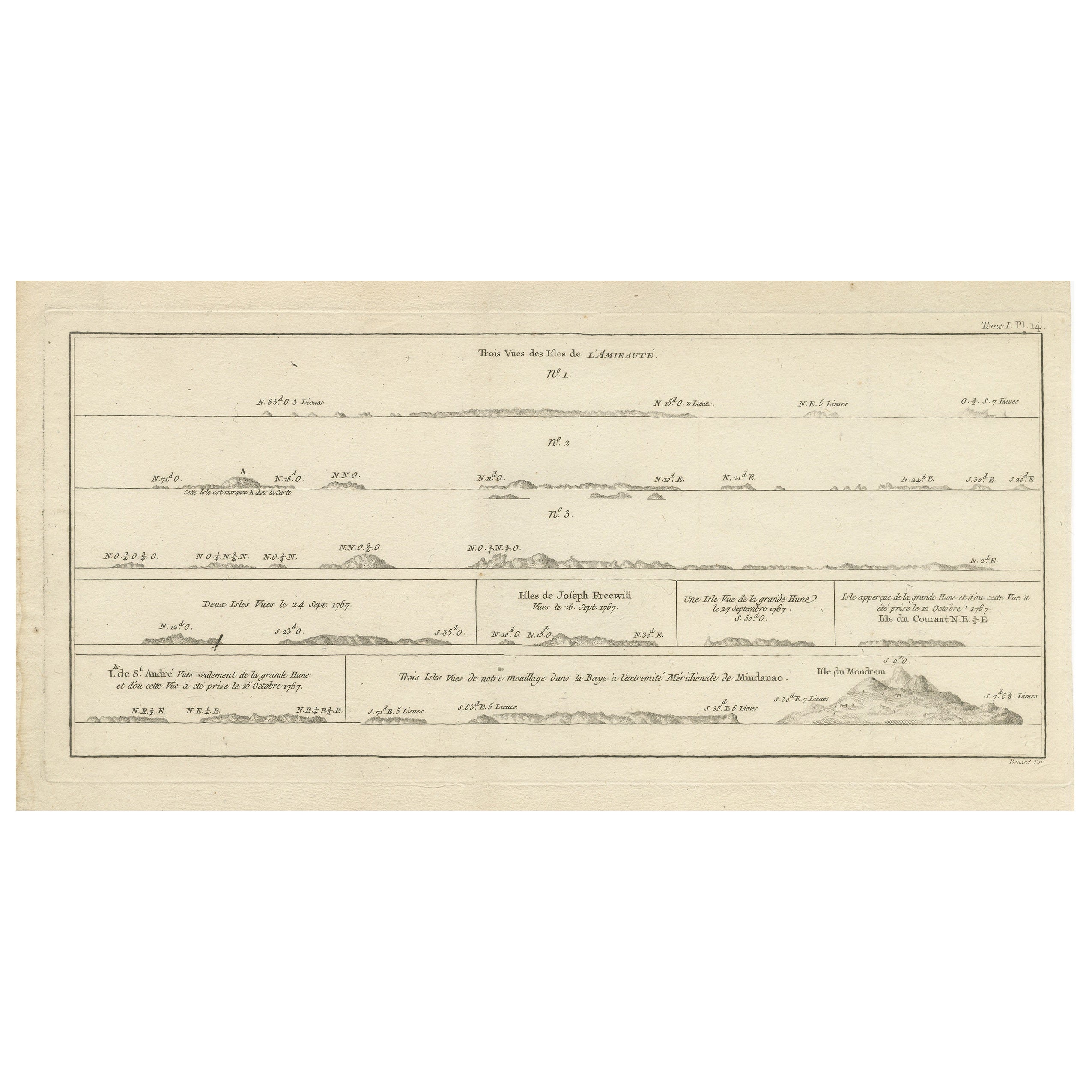
- Antique Map of the Admiralty Islands, Bismarck ArchipelagoLocated in Langweer, NLAntique map titled 'Trois Vues des Isles de l'Amirauté'. Several coastal views of the Admiralty Islands, Bismarck Archipelago, to the north of New Guinea in the South Pacific Ocean. ...Category
Antique Late 18th Century Maps
MaterialsPaper
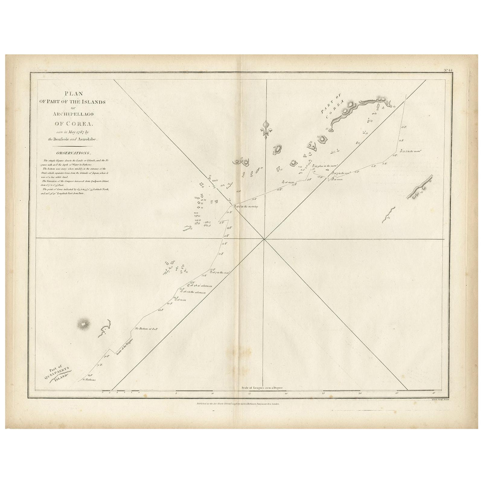
- Antique Map of Part of the Korean Archipelago, 1798Located in Langweer, NLAntique map titled 'Plan of Part of the Islands or Archipellago of Corea'. This map depicts part of the Korean Archipelago and originates from Charts and Plates to La Pérouse...Category
Antique Late 18th Century Maps
MaterialsPaper
- Antique Map of the Nias Archipelago, Sumatra, Indonsia, 1900Located in Langweer, NLAntique map of Nias Island and surrounding islands including the Banyak islands, Pini island and Simeulue Island. This map originates from 'Atlas van Nederlandsch Oost- en West-Indië...Category
20th Century Maps
MaterialsPaper


You May Also Like
- "San Francisco, Upper California” 1851 Antique Map of San FranciscoLocated in Colorado Springs, COThis is a pictorial lettersheet view of the city and harbor of San Francisco. This lithograph was printed on grey wove paper, across a double sheet, by famed lithographers Britton & ...Category
Antique 1850s American Prints
MaterialsPaper
- Original Antique English County Map, Herefordshire, J & C Walker, 1851Located in St Annes, LancashireGreat map of Herefordshire Original colour By J & C Walker Published by Longman, Rees, Orme, Brown & Co. 1851 Unframed.Category
Antique 1850s English Other Maps
MaterialsPaper
- Original Antique English County Map, Rutland, J & C Walker, 1851Located in St Annes, LancashireGreat map of Rutland Original colour By J & C Walker Published by Longman, Rees, Orme, Brown & Co. 1851 Unframed.Category
Antique 1850s English Other Maps
MaterialsPaper
- Original Antique English County Map, Durham, J & C Walker, 1851Located in St Annes, LancashireGreat map of Durham Original colour By J & C Walker Published by Longman, Rees, Orme, Brown & Co. 1851 Unframed.Category
Antique 1850s English Other Maps
MaterialsPaper
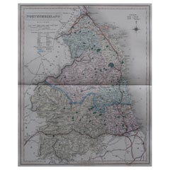
- Original Antique English County Map, Northumberland, J & C Walker, 1851Located in St Annes, LancashireGreat map of Northumberland Original colour By J & C Walker Published by Longman, Rees, Orme, Brown & Co. 1851 Unframed.Category
Antique 1850s English Other Maps
MaterialsPaper
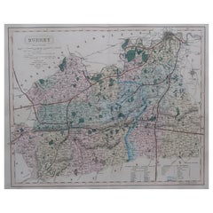
- Original Antique English County Map - Surrey. J & C Walker. 1851Located in St Annes, LancashireGreat map of Surrey Original colour By J & C Walker Published by Longman, Rees, Orme, Brown & Co. 1851 Unframed.Category
Antique 1850s English Other Maps
MaterialsPaper