Items Similar to 1797 Tardieu Map of Southeast Asia: The Malay Archipelago and Beyond

Want more images or videos?
Request additional images or videos from the seller
1 of 8
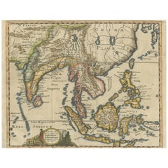
1797 Tardieu Map of Southeast Asia: The Malay Archipelago and Beyond
About the Item
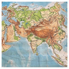
An original historical map titled 'Presqu' Île Au Dela Du Gange et Archipel De L'Inde', created by Pierre Francois Tardieu and published in the "Atlas Universel" by Pierre Grégoire Chanlaire & Edmonde Mentelle in Paris, 1797. It depicts the region from Bangladesh to Papua New Guinea, with a central focus on Borneo and the Philippines. Printed on strong hand-pressed paper.
Step back into the age of exploration with this meticulously hand-colored 1797 engraving by the esteemed cartographer Pierre Francois Tardieu. This rare collector's piece, from the Atlas Universel, offers a detailed glimpse into the maritime heart of Southeast Asia, highlighting the 'Presqu' Île Au Dela Du Gange et Archipel De L'Inde'. It is a treasure trove for map enthusiasts and historians alike, featuring the Malay Archipelago with remarkable precision. Borneo and the Philippines are centrally placed, flanked by the intricate web of islands stretching from Bangladesh to the exotic east of Papua New Guinea. Singapore is mentioned already. This decorative and educational map is a must-have for connoisseurs of geographic art and a unique testament to the cartographic achievements of the 18th century."
Such a description would cater to collectors interested in maritime history, cartographic art, and regional maps of Asia, enhancing the allure and perceived value of the map.
Keywords:
- Antique map
- Hand-colored engraving
- Pierre Francois Tardieu
- 18th-century cartography
- Atlas Universel
- Southeast Asia historical map
- Maritime Southeast Asia
- Collectible map
- Decorative map
- Educational piece
- Geographic art
- Borneo and Philippines
- Exploration era
- Nautical chart
- Dimensions:Height: 25.2 in (64 cm)Width: 19.1 in (48.5 cm)Depth: 0 in (0.02 mm)
- Materials and Techniques:Paper,Engraved
- Period:1790-1799
- Date of Manufacture:1797
- Condition:Condition: Good, given age. General age-related soiling but mainly outside the image in the margins. Beautiful hand-coloured, with some creasing along the centrefold. Latin text on the reverse. Restored tear in outer lower margin; otherwise fine.
- Seller Location:Langweer, NL
- Reference Number:
About the Seller
5.0
Platinum Seller
These expertly vetted sellers are 1stDibs' most experienced sellers and are rated highest by our customers.
Established in 2009
1stDibs seller since 2017
1,922 sales on 1stDibs
Typical response time: <1 hour
- ShippingRetrieving quote...Ships From: Langweer, Netherlands
- Return PolicyA return for this item may be initiated within 14 days of delivery.
More From This SellerView All
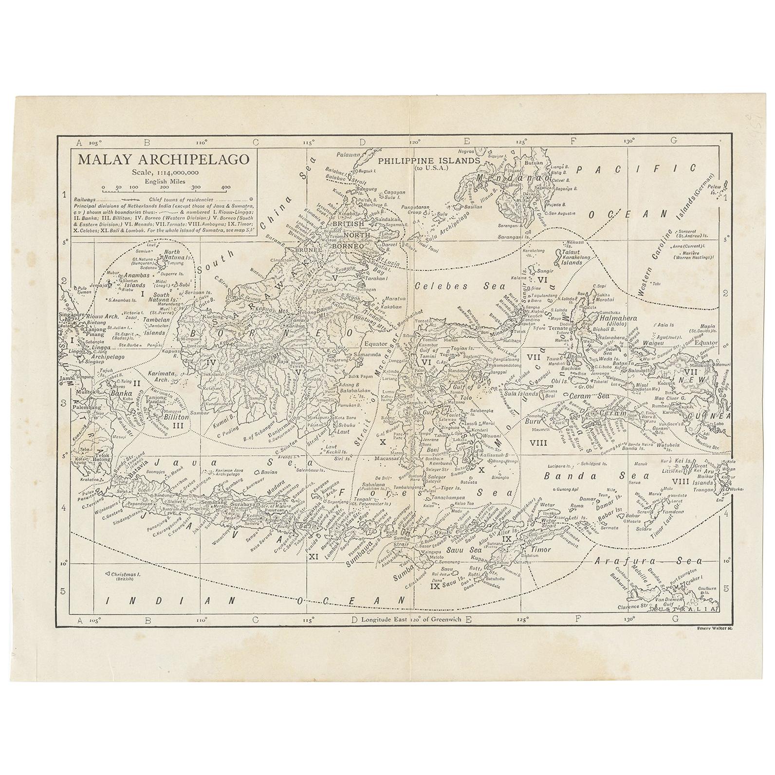
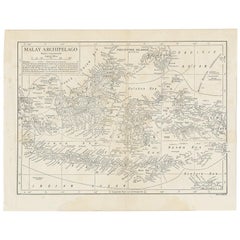
- Antique Map of the Malay Archipelago by Walker, 1911Located in Langweer, NLAntique map titled 'Malay Archipelago'. Old map of the Malay Archipelago including Borneo, Celebes, New Guinea, Java, Timor and others. This map ...Category
Early 20th Century Maps
MaterialsPaper
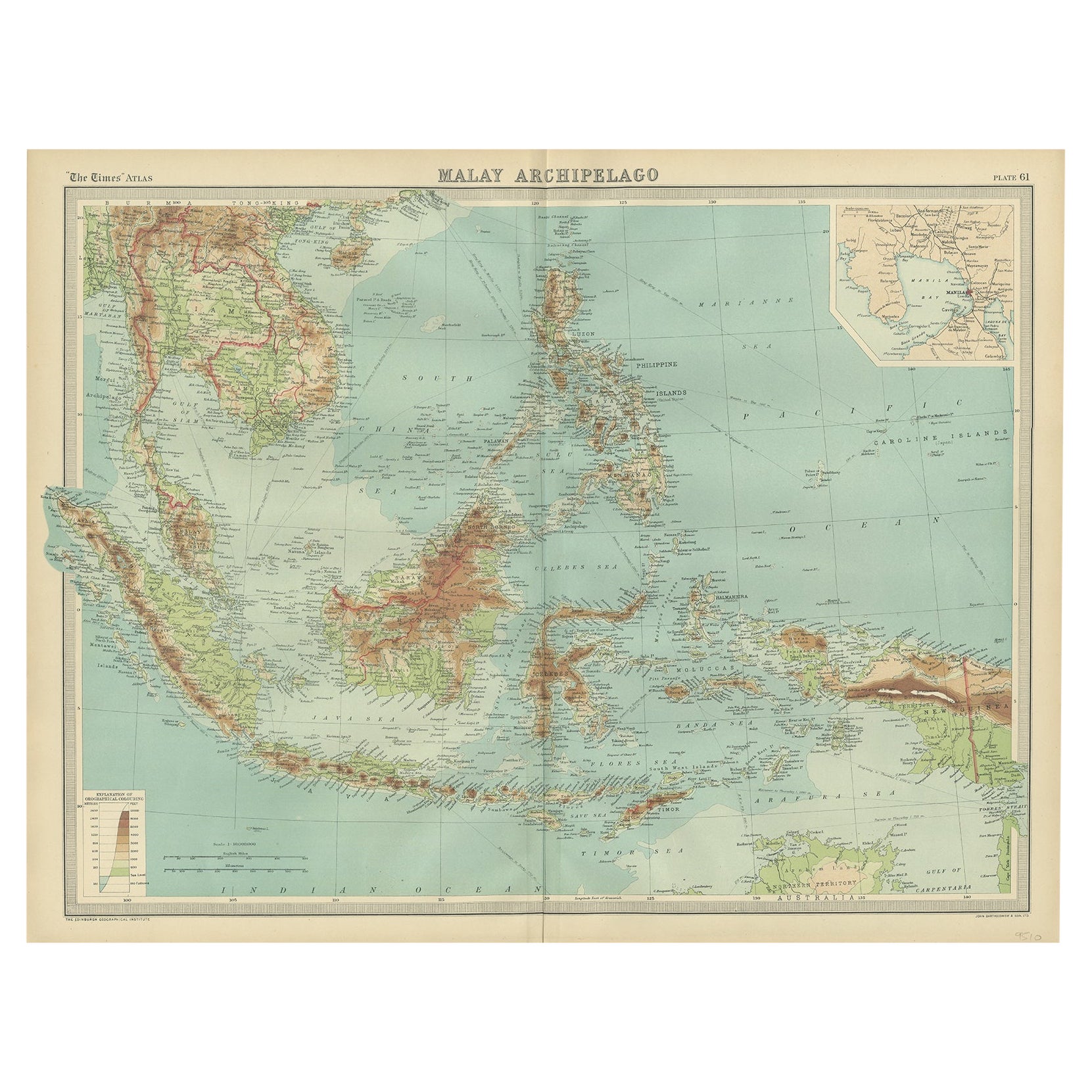
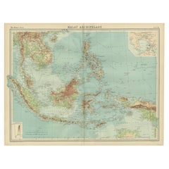
- Old Map of South East Asia Showing the Malay Archipelago, incl Borneo etc, 1922Located in Langweer, NLAntique map of South East Asia titled 'Malay Archipelago'. Old map of South East Asia depicting the Malay Archipelago including Sumatra, Java...Category
Vintage 1920s Maps
MaterialsPaper
- Antique Map of India to Southeast AsiaLocated in Langweer, NLAntique map titled 'Indes en-decà et au-delà du Gange'. Original old map of India to Southeast Asia, showing India, Nepal, Bhutan, Sri Lanka (Ceylon), Myanmar (Birma), part of Indone...Category
Antique Mid-19th Century Maps
MaterialsPaper
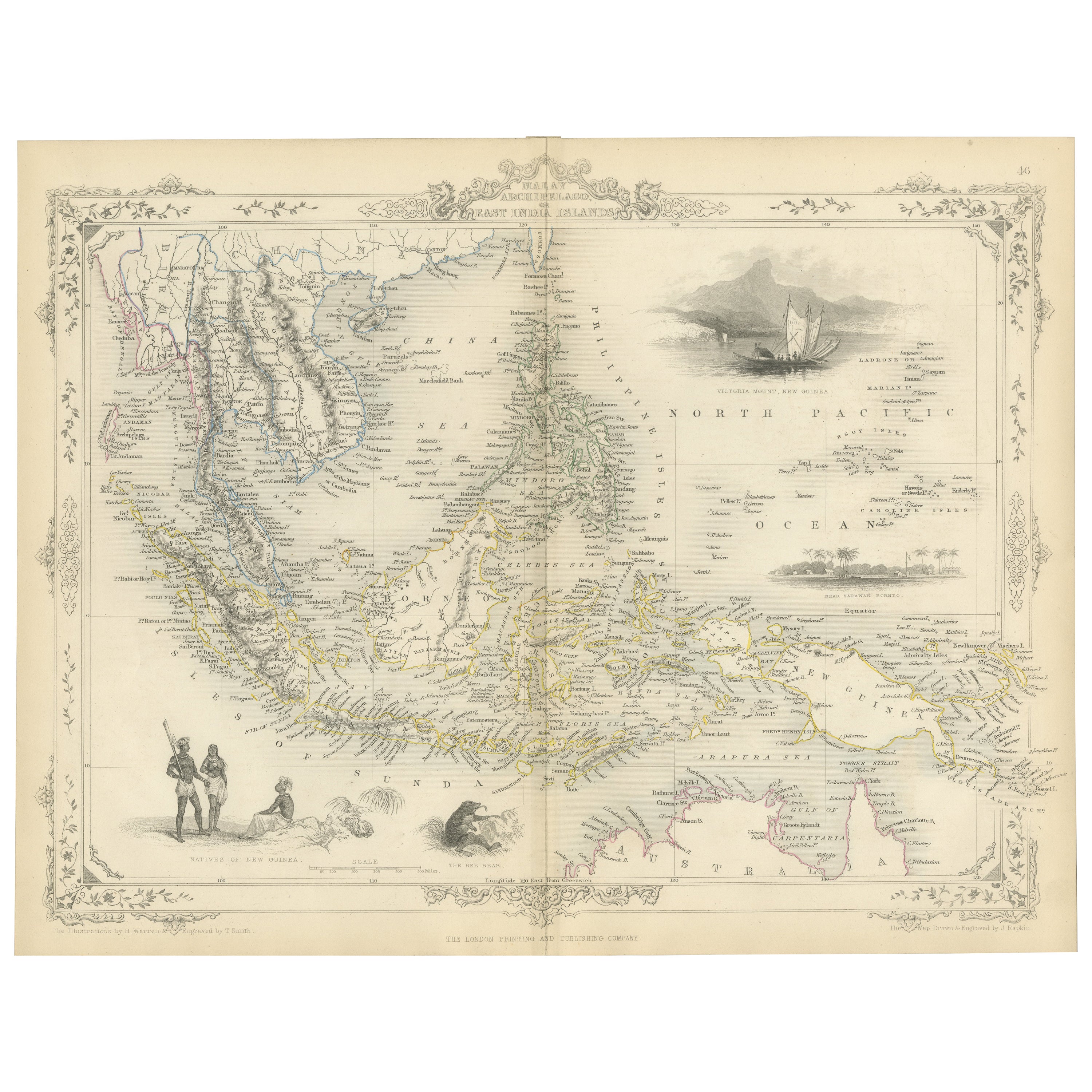
- Antique Map of the Malay Archipelago with Images of Indigenous People, 1851Located in Langweer, NLJohn Tallis & Company, often simply known as Tallis, was renowned for the production of maps and illustrated geographical publications in the mid-19th century. Tallis maps, such as t...Category
Antique 1850s Maps
MaterialsPaper
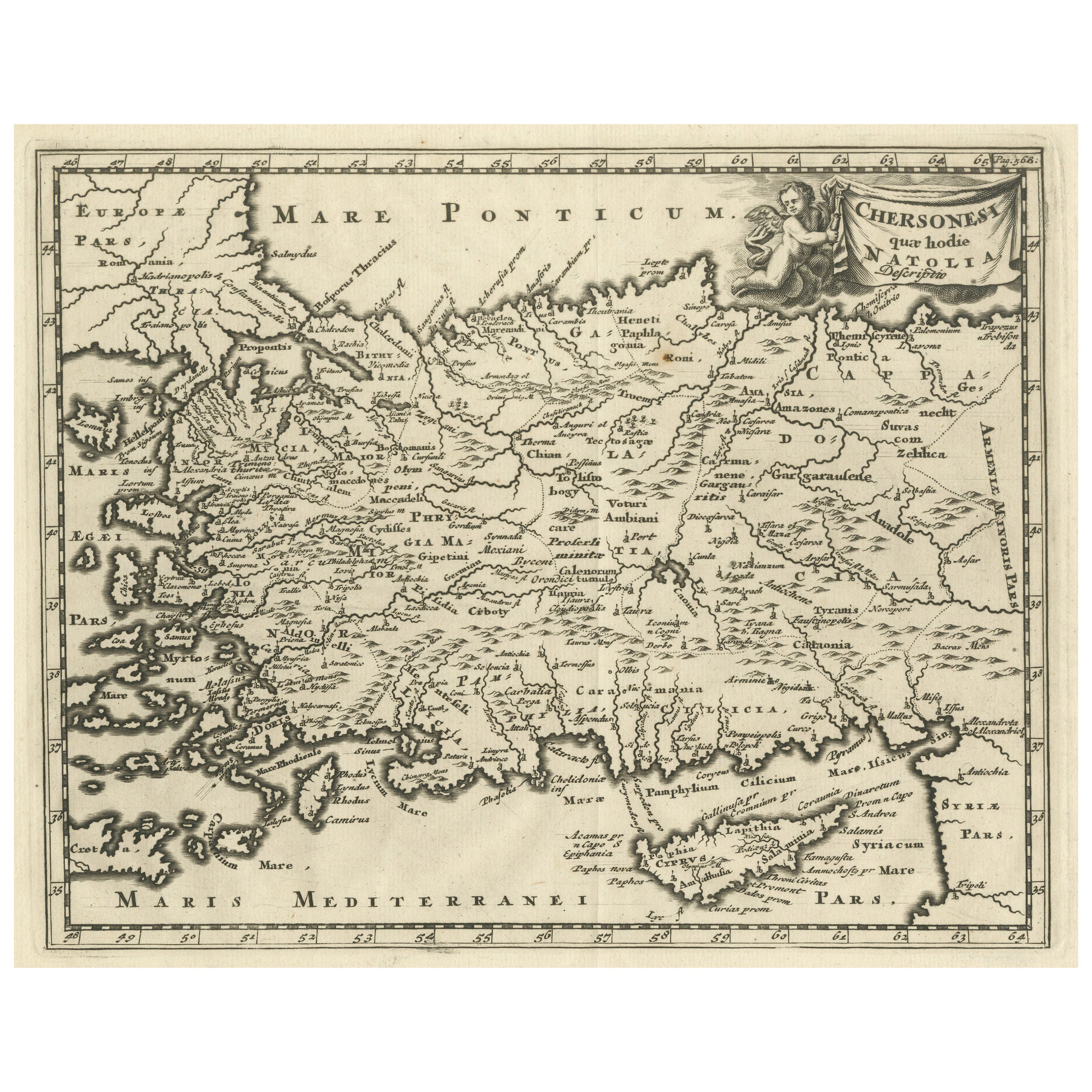
- Antique Map of Asia Minor including part of the Greek Archipelago and CyprusLocated in Langweer, NLAntique map titled 'Chersonesi quae hodie Natolia Descriptio'. Decorative, smaller map of Asia Minor including part of the Greek Archipelago and Cyprus. The drape-style title cartouc...Category
Antique Mid-18th Century Maps
MaterialsPaper
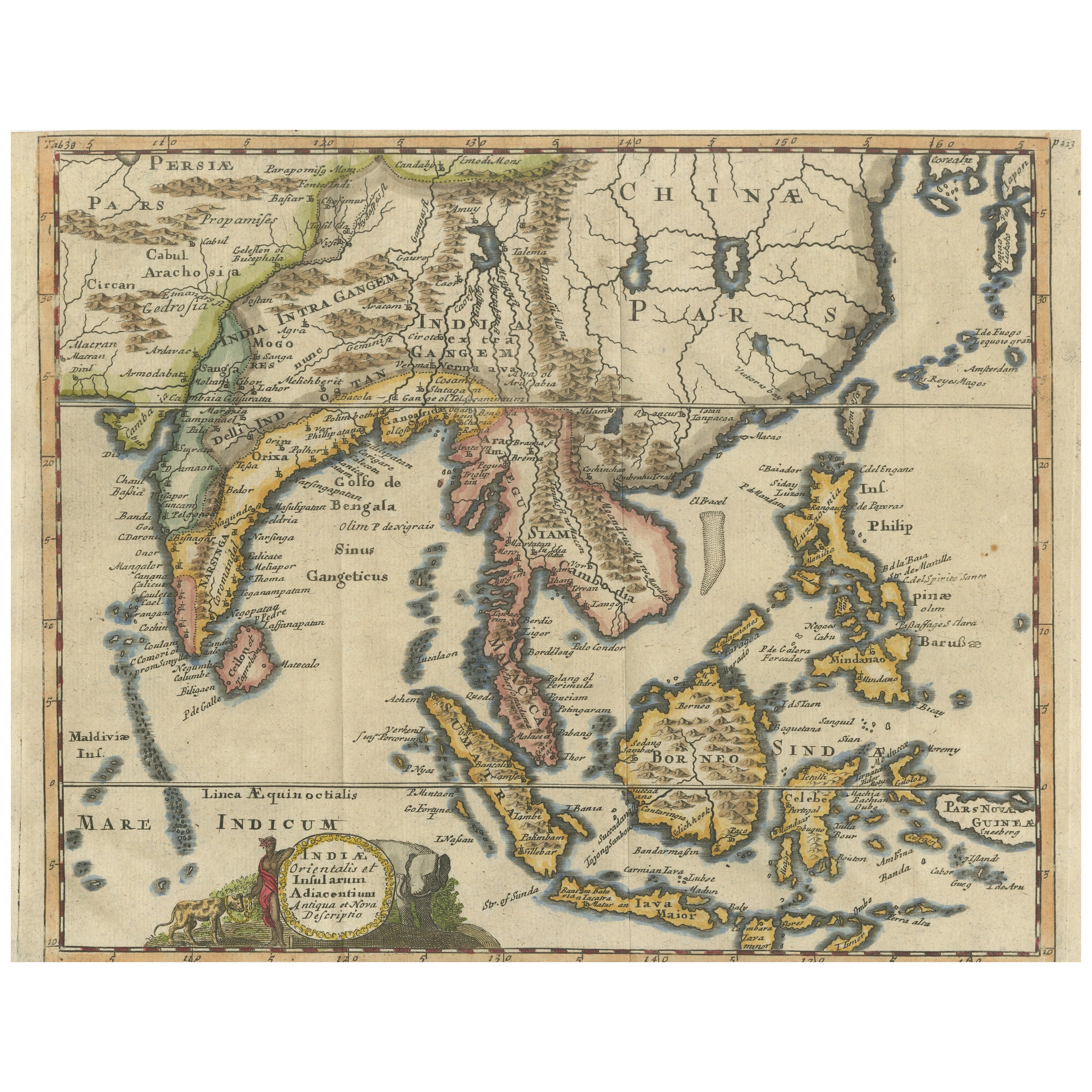
- Antique Map of Southeast Asia, China, Philippines and IndiaLocated in Langweer, NLAntique map titled 'Indiae Orientalis et Insularum Adiacentium'. Decorative map of Southeast Asia, China, Philippines, and India. A native holds a wild dog or hyena on a chain, while...Category
Antique Early 18th Century Maps
MaterialsPaper

You May Also Like
- 1812 United States Map, by Pierre Tardieu, Antique French Map Depicting the U.S.By Pierre François TardieuLocated in Colorado Springs, CO1812 "United States of Nth America -- Carte des Etats-Unis De L'Amerique Septentrionale" Two-Sheet Map by Tardieu This attractive map, published in Paris in 1812, is one of the most rare large format maps from the period. It features a view of the East Coast of the U.S. from Maryland to just below South Carolina. Additionally, Ellicott’s plan for the City of Washington D.C. is included at the top right and an illustration of Niagara Falls is shown at the bottom right with a description in both French and English. This extremely detailed map not only depicts the mountainous regions of the southeastern U.S., but also includes names of regions, rivers, and towns. Based on the first state of Arrowsmith’s 4-sheet map of the United States, this map is completely engraved by Tardieu in Paris and showcases high quality engravings. This detailed map of the recently independent United States includes one of the largest and earliest examples of the Ellicott plan of Washington DC. The artist, Pierre François Tardieu (PF Tardieu) was a very well-known map engraver, geographer, and illustrator. Awarded a bronze medal by King Louis-Phillipe for the accuracy and beauty of his map-making, Tardieu produced many fine works including maps of Louisiana...Category
Antique 1810s French Maps
MaterialsPaper
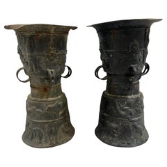
- Pair of Southeast Asian Ceremonial Rain DrumsLocated in Houston, TXPair of Southeast Asian ceremonial rain drums. Estimated that the bronze drums dates to the early 19th century. The top surface is adorned with a ceremonial star and tops are not tha...Category
Antique Early 1800s Indonesian Chinese Export Musical Instruments
MaterialsBronze
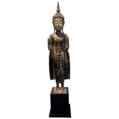
- Antique Giltwood Buddha Statue Southeast AsiaLocated in Atlanta, GAA delicately carved wood Buddha in an upright standing posture with a double Abhaya mudra. The statue displays a gilt surface with beautiful patina and some minor wear. The face was ...Category
Antique 19th Century Thai Other Sculptures and Carvings
MaterialsGold Leaf
- Original Antique Map of Asia. C.1780Located in St Annes, LancashireGreat map of Asia Copper-plate engraving Published C.1780 Two small worm holes to right side of map Unframed.Category
Antique Early 1800s English Georgian Maps
MaterialsPaper

- Huge Europe and Asia Vintage Wall MapLocated in San Diego, CAA huge Europe and Asia vintage wall map, circa 1950s. The map is in fair vintage condition and measures 78"W x 73"H". #2863Category
Mid-20th Century American Maps
MaterialsPaper
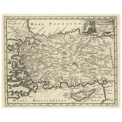
- Hand-Colored 18th Century Homann Map of the Black Sea, Turkey and Asia MinorBy Johann Baptist HomannLocated in Alamo, CAAn attractive original early 18th century hand-colored map of the Black Sea and Turkey entitled "Carte de L'Asie Minevre ou de la Natolie et du Pont Evxin Tiree des Voyages et des Ob...Category
Antique Early 18th Century German Maps
MaterialsPaper


Recently Viewed
View AllMore Ways To Browse
1859 Asia Map
Antique Map Antilles
Formosa Vintage Map
Map Zanzibar
Minature Map
Vincenzo Coronelli On Sale
Anguilla Map
Antique Cabbage Cutter
Antique Maps Denver
Antique Maps Washington Dc
Brinkman Co
Britton And Rey Lithograph
Cartier 1730
Christoph Weigel On Sale
Clivia Ducatus Et Ravestein Dominium
Collectible Barbies
Cyclades Map
Devonia Antique