Items Similar to Antique Map of Southeast Asia, China, Philippines and India


Want more images or videos?
Request additional images or videos from the seller
1 of 6
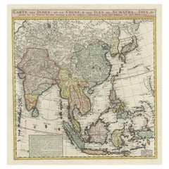
Antique Map of Southeast Asia, China, Philippines and India
About the Item
Antique map titled 'Indiae Orientalis et Insularum Adiacentium'. Decorative map of Southeast Asia, China, Philippines, and India. A native holds a wild dog or hyena on a chain, while an elephant glares immediately adjacent. The map was published in London by John Nicholson in 1711 as part of Philip Cluver’s 'Introductio in Universam Geographiam'. First published in 1624, the massive six-volume geography work proved so popular that it was replicated in numerous versions and languages over more than a century.
- Dimensions:Height: 8.86 in (22.5 cm)Width: 12.41 in (31.5 cm)Depth: 0.02 in (0.5 mm)
- Materials and Techniques:
- Period:
- Date of Manufacture:1711
- Condition:General age-related toning. Original folding lines. Minor wear and soiling. Narrow top and bottom margin. Blank verso. Please study image carefully.
- Seller Location:Langweer, NL
- Reference Number:
About the Seller
5.0
Platinum Seller
These expertly vetted sellers are 1stDibs' most experienced sellers and are rated highest by our customers.
Established in 2009
1stDibs seller since 2017
1,916 sales on 1stDibs
Typical response time: <1 hour
- ShippingRetrieving quote...Ships From: Langweer, Netherlands
- Return PolicyA return for this item may be initiated within 14 days of delivery.
More From This SellerView All
- Antique Map of India to Southeast AsiaLocated in Langweer, NLAntique map titled 'Indes en-decà et au-delà du Gange'. Original old map of India to Southeast Asia, showing India, Nepal, Bhutan, Sri Lanka (Ceylon), Myanmar (Birma), part of Indone...Category
Antique Mid-19th Century Maps
MaterialsPaper
- Antique Map of India and Southeast Asia by Sanson '1654'Located in Langweer, NLAntique map titled 'Partie Meridionale de l'Inde'. Early map of India and Southeast Asia. The map shows most of modern India, Bangladesh and Burma, the whole of Sri Lanka, Thailand, ...Category
Antique Mid-17th Century Maps
MaterialsPaper
- Antique Map of India and Southeast Asia by Balbi '1847'Located in Langweer, NLAntique map titled 'India en deçà et au delà du Gange'. Original antique map of India and Souteast Asia. This map originates from 'Abrégé de Géographie (..)' by Adrien Balbi. Publish...Category
Antique Mid-19th Century Maps
MaterialsPaper
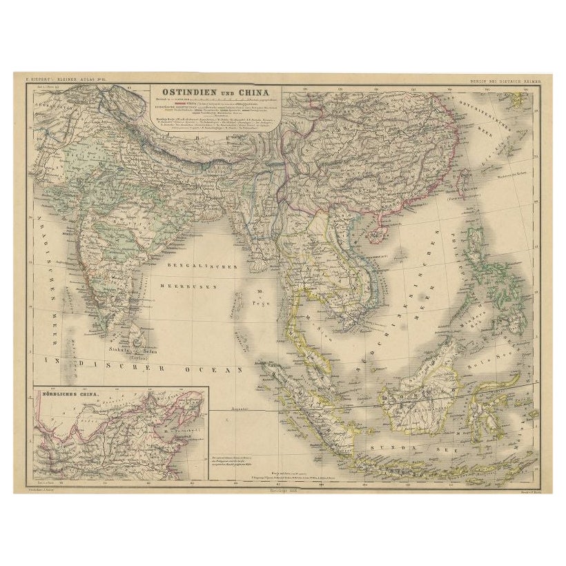
- Antique Map of Southeast Asia and China by Kiepert, c.1870By Thomas KitchinLocated in Langweer, NLAntique map titled 'Ostindien und China'. Old map of Southeast Asia and China. This map originates from 'H. Kiepert's Kleiner Atlas der Neueren Geographie für Schule und Haus'. Artis...Category
Antique 19th Century Maps
MaterialsPaper
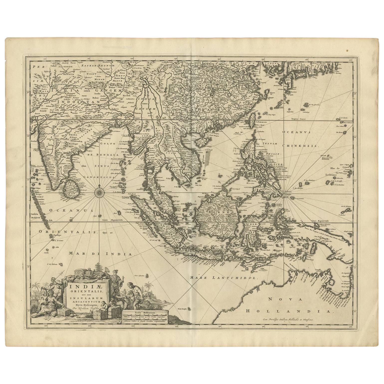
- Antique Map of Southeast Asia 'India, Indonesia' by N. Visscher, circa 1670Located in Langweer, NLAntique map titled 'Indiae Orientalis, nec non Insularum Adiacentium Nova Descriptio.' The map centers on the Strait of Malacca and Malay Peninsula. It extends from India and the Mal...Category
Antique Mid-17th Century Maps
MaterialsPaper
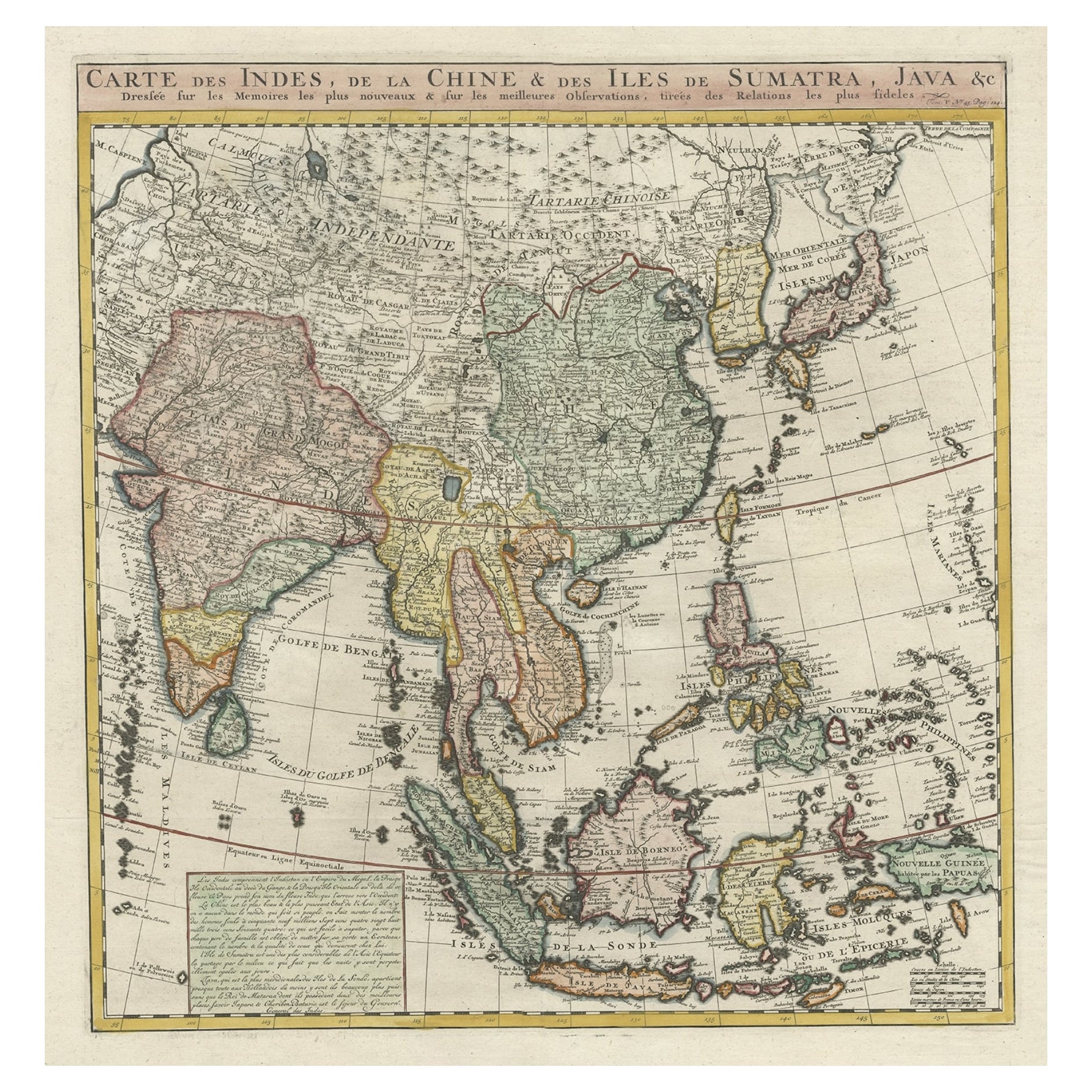
- Detailed Original Antique Map of India, Southeast Asia and the Far East, 1719Located in Langweer, NLAntique map titled 'Carte des Indes, de la Chine & des Iles de Sumatra, Java & c'. Detailed map of India, Southeast Asia and the Far East, extending from Gujerat to the supposed "T...Category
Antique 1710s Maps
MaterialsPaper


You May Also Like
- Antique French Map of Asia Including China Indoneseia India, 1783Located in Amsterdam, Noord HollandVery nice map of Asia. 1783 Dedie au Roy. Additional information: Country of Manufacturing: Europe Period: 18th century Qing (1661 - 1912) Condition: Overall Condition B (Good Used)...Category
Antique 18th Century European Maps
MaterialsPaper
- Antique 1803 Italian Map of Asia Including China Indoneseia IndiaLocated in Amsterdam, Noord HollandAntique 1803 Italian Map of Asia Including China Indoneseia India Very nice map of Asia. 1803. Additional information: Type: Map Country of Manufacturing: Europe Period: 19th centu...Category
Antique 19th Century European Maps
MaterialsPaper
- Antique Giltwood Buddha Statue Southeast AsiaLocated in Atlanta, GAA delicately carved wood Buddha in an upright standing posture with a double Abhaya mudra. The statue displays a gilt surface with beautiful patina and some minor wear. The face was ...Category
Antique 19th Century Thai Other Sculptures and Carvings
MaterialsGold Leaf
- Original Antique Map of India. C.1780Located in St Annes, LancashireGreat map of India Copper-plate engraving Published C.1780 Three small worm holes to right side of map and one bottom left corner Unframed.Category
Antique Early 1800s English Georgian Maps
MaterialsPaper

- Original Antique Map of Asia. C.1780Located in St Annes, LancashireGreat map of Asia Copper-plate engraving Published C.1780 Two small worm holes to right side of map Unframed.Category
Antique Early 1800s English Georgian Maps
MaterialsPaper

- Pair of Southeast Asian Ceremonial Rain DrumsLocated in Houston, TXPair of Southeast Asian ceremonial rain drums. Estimated that the bronze drums dates to the early 19th century. The top surface is adorned with a ceremonial star and tops are not tha...Category
Antique Early 1800s Indonesian Chinese Export Musical Instruments
MaterialsBronze


Recently Viewed
View AllMore Ways To Browse
Collectibles India
Nicholsons Antiques
Philippines Antique Furniture
Holy Land Map
Oversized Map
Antique Maps Of Ancient World
Victorian Floor Vase
Dutch Provinces
Map Of Charlevoix
Arkansas Map
Antique Chinese Rob
Tanzania Antique Map
Vintage Schoolroom
1847 Rio
Abraham Ortelius On Sale
Aigue Marine
Atlas Indu
Dan Rizzi