Items Similar to Cortesi's Masterpiece: A Comprehensive and Authoritative Map of Uruguay, 1903
Want more images or videos?
Request additional images or videos from the seller
1 of 9
Cortesi's Masterpiece: A Comprehensive and Authoritative Map of Uruguay, 1903
About the Item
Antique map titled 'Mapa de la Republica Oriental del Uruguay'. Large and detailed folding map of Uruguay. This monumental map depicts all of Uruguay with unprecedented accuracy and detail. Impressively, it serves the multiple roles of being an advanced topographic, economic and political map, as well as being a meticulous sea chart of the Rio de la Plata and the adjacent waters of the Atlantic. The republic's 20 departments are defined in various colors, while a legend, 'Referencias' identifies symbols representing the locations of departmental capitals, town, roads, railways, public schools and lighthouses, amongst other details. Every single river and stream is delineated and named and the ridges of hills are delicately expressed. The map features four insets, including a large map of the capital, Montevideo, as well as maps of Colonia, Maldonado and Punta del Este and the Island of Flores. The hydrographical information provided is truly profound, and renders the map fit for use in maritime commerce.
In 1901, the Uruguayan House of Representatives commissioned the geographer Saturnino Cortesi to employ the most progressive geographical sources, both military and civilian, to devise an authoritative national map of the republic. Cortesi clearly had access to a vast archive of topographical surveys, as well as sea charts issued by Britain's Royal Navy. As stated on the map, Cortesi's manuscript was reviewed and approved by the National Department of Engineers and authorized for its publication by decree of the Ministry of Development of Uruguay ('El presente mapa construido por Saturnino Cortesi y Anibal C. Mendez ha sido examinado y aprobado Departamento N. de Ingenieros y autorizada su publicacion por decreto del Ministerio de Fomento').
Cortesi was assisted in preparing the map for publication by Anibal C. Mendez, and it was chromolithographed by La Minerva Tipografia y Lithografia in Montevideo. Issued in 1903, it was by far the grandest map ever printed in Uruguay to date.
Cortesi's Mapa de la Republica Oriental del Uruguay was the authoritative and official national map of Uruguay, and appeared at an especially critical time in the republic's history. The second half of the 19th-century had been a time of tremendous instability in the wake of the great civil war, La Guerra Grande (1839-51). In 1903, the year the map was issued, José Batlle y Ordoñez was elected president, ushering in a generation of economic prosperity and relative political stability. The present map would have served as a vital tool in planning Uruguay's development during this period of rapid growth and change.
Reference: Proceedings of the Second Pan American Scientific Congress (Washington, D.C., 1917), p.656.
- Dimensions:Height: 72.84 in (185 cm)Width: 50.79 in (129 cm)Depth: 0.02 in (0.5 mm)
- Materials and Techniques:
- Period:
- Date of Manufacture:1903
- Condition:Repaired: Rebacking with linen. Minor structural damages. Few traces of worm holes (nearly invisible because of rebacking). Please study images carefully.
- Seller Location:Langweer, NL
- Reference Number:
About the Seller
5.0
Platinum Seller
These expertly vetted sellers are 1stDibs' most experienced sellers and are rated highest by our customers.
Established in 2009
1stDibs seller since 2017
1,933 sales on 1stDibs
Typical response time: <1 hour
- ShippingRetrieving quote...Ships From: Langweer, Netherlands
- Return PolicyA return for this item may be initiated within 14 days of delivery.
More From This SellerView All
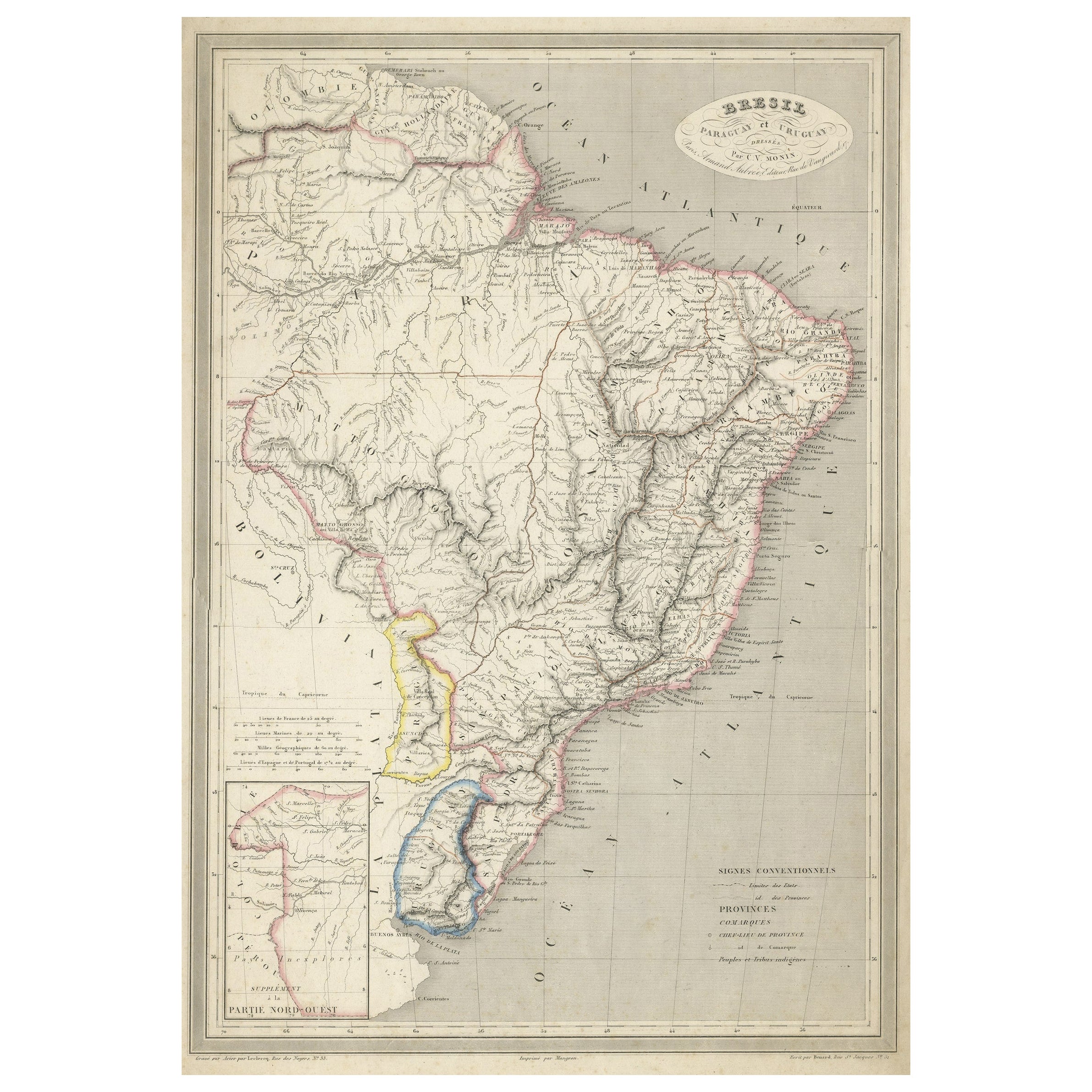
- Antique Map of of Brazil, Paraguay and UruguayLocated in Langweer, NLAntique map titled 'Bresil Paraguay et Uruguay'. Fine steel engraved map of Brazil, Paraguay and Uruguay. Engraved by Leclercq and published by Armand Aubree in "Atlas Classique et U...Category
Antique Mid-19th Century Maps
MaterialsPaper
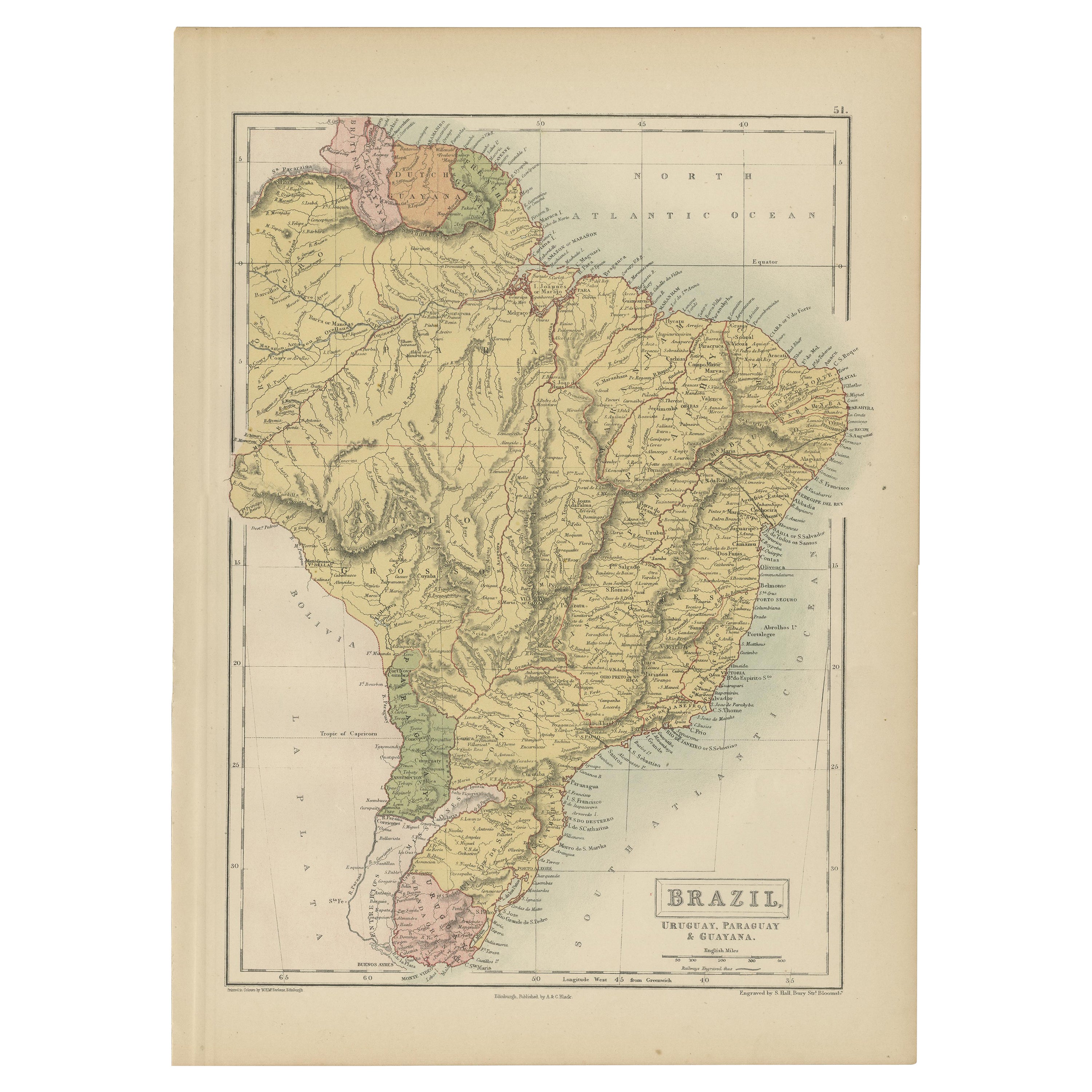
- Antique Map of Brazil, Uruguay, Paraguay and Guyana by A & C. Black, 1870Located in Langweer, NLAntique map titled 'Brazil'. Original antique map of Brazil, Uruguay, Paraguay and Guyana. This map originates from ‘Black's General Atlas of The...Category
Antique Late 19th Century Maps
MaterialsPaper
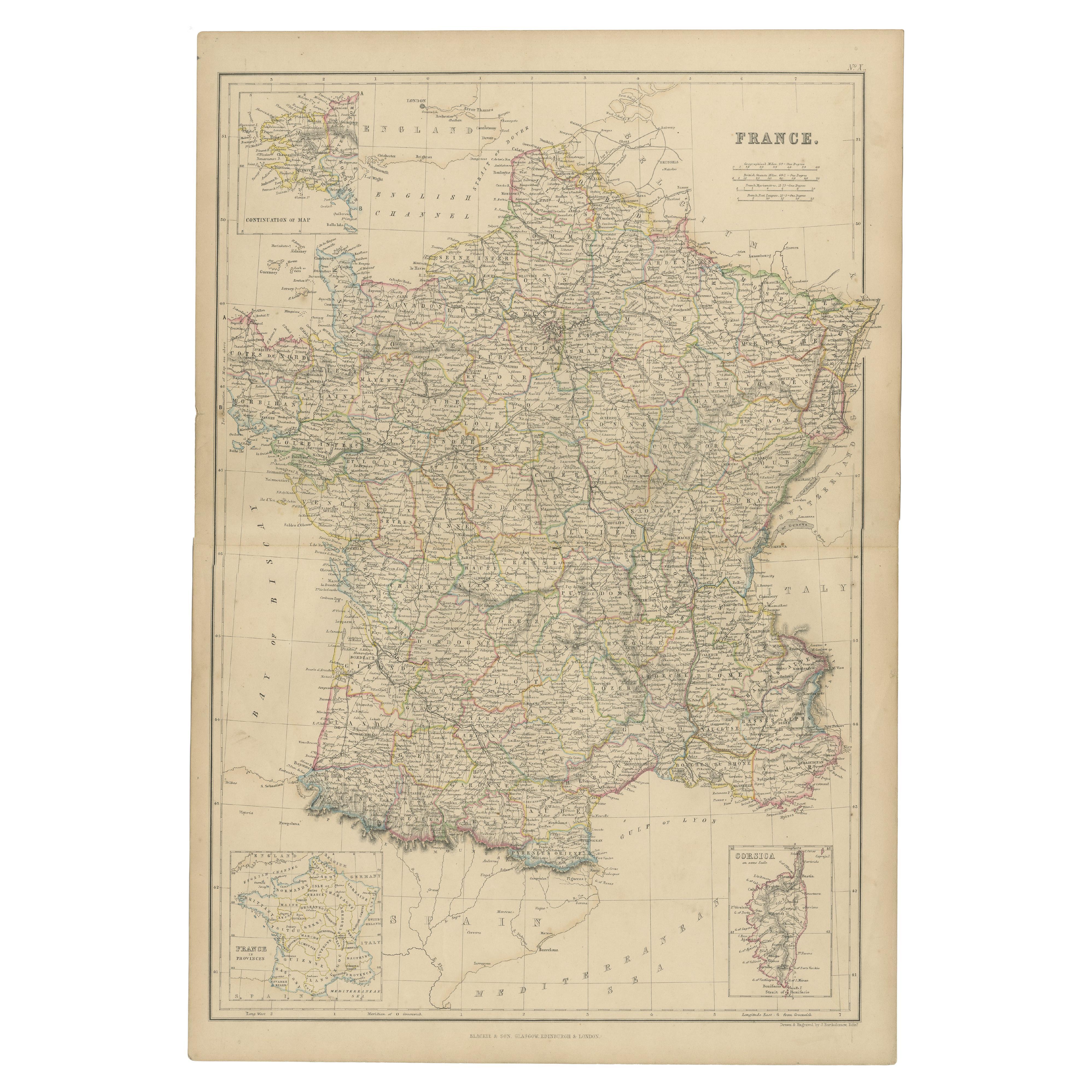
- 1859 Classic Map of France: Blackie's Imperial Geographic MasterpieceLocated in Langweer, NLThe "Antique Map of France" from 'The Imperial Atlas of Modern Geography', published in 1859 by W. G. Blackie, is a historically valuable cartographic work that offers a comprehensiv...Category
Antique Mid-19th Century Maps
MaterialsPaper
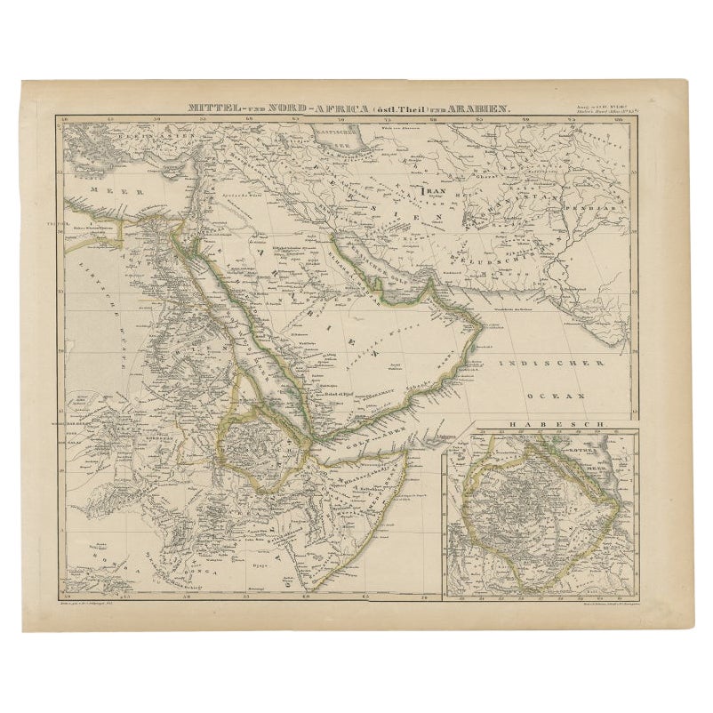
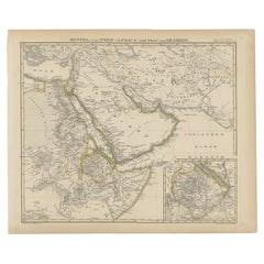
- Antique Map of Africa and Arabia with Inset Map of Ethiopia and Eritrea, 1845Located in Langweer, NLAntique map titled 'Mittel- und Nord-Africa (östl. Theil) und Arabien'. This map depicts North and Central Africa and Arabia with an inset map of Habesch (Ethiopia and Eritrea). Ar...Category
Antique 19th Century Maps
MaterialsPaper
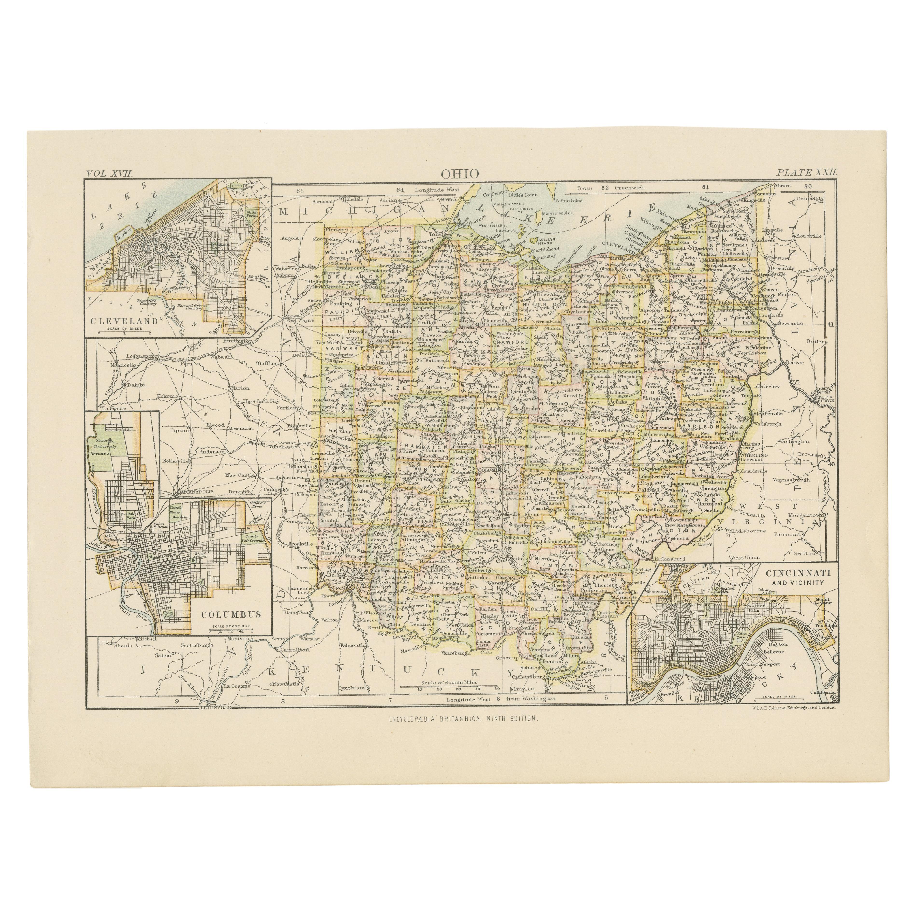
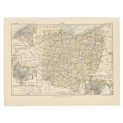
- Antique Map of Ohio, with Inset Maps of Cleveland, Columbus and CincinnatiLocated in Langweer, NLAntique map titled 'Ohio'. Original antique map of Ohio, United States. With inset maps of Cleveland, Columbus and Cincinnati. This print originates from 'Encyclopaedia Britannica', ...Category
Antique Late 19th Century Maps
MaterialsPaper
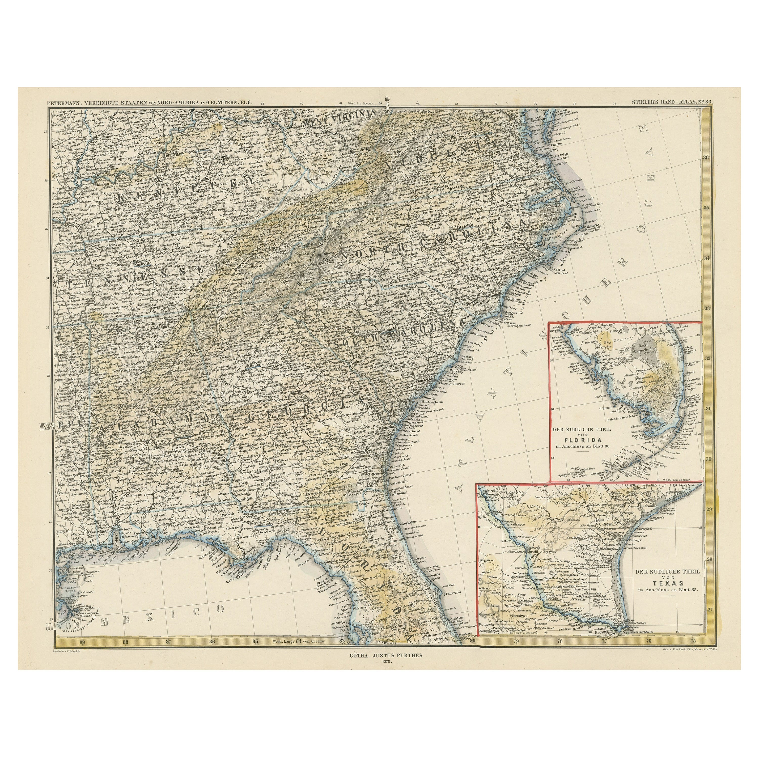
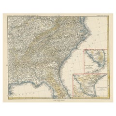
- Antique Map of the Region of Georgia with Inset Maps of Florida and TexasLocated in Langweer, NLAntique map of part of the United States showing Alabama, Georgia, North Carolina, South Carolina, Tennessee, Kentucky, Virginia and part of Florida. With inset maps of the southern ...Category
Antique Late 19th Century Maps
MaterialsPaper

You May Also Like
- Original Antique Map of Spain and Portugal, circa 1790Located in St Annes, LancashireSuper map of Spain and Portugal Copper plate engraving by A. Bell Published, circa 1790. Unframed.Category
Antique 1790s English Other Maps
MaterialsPaper
- Antique Map of Principality of MonacoBy Antonio Vallardi EditoreLocated in Alessandria, PiemonteST/619 - "Old Geographical Atlas of Italy - Topographic map of ex-Principality of Monaco" - ediz Vallardi - Milano - A somewhat special edition ---Category
Antique Late 19th Century Italian Other Prints
MaterialsPaper
- Map of the Republic of GenoaLocated in New York, NYFramed antique hand-coloured map of the Republic of Genoa including the duchies of Mantua, Modena, and Parma. Europe, late 18th century. Dimension: 25...Category
Antique Late 18th Century European Maps
- Original Antique Map of Ireland- Tipperary and Waterford. C.1840Located in St Annes, LancashireGreat map of Tipperary and Waterford Steel engraving Drawn under the direction of A.Adlard Published by How and Parsons, C.1840 Unframed.Category
Antique 1840s English Maps
MaterialsPaper
- Old Nautical Map of CorsicaLocated in Alessandria, PiemonteST/556/1 - Old map of Corsica isle, surveyed by Captain Hell, of the French Royal Navy in 1824, engraved and published on 1874, with additions and corre...Category
Antique Early 19th Century English Other Prints
MaterialsPaper
- Old Horizontal Map of EnglandBy TassoLocated in Alessandria, PiemonteST/520 - Old rare Italian map of England, dated 1826-1827 - by Girolamo Tasso, editor in Venise, for the atlas of M.r Le-Sage.Category
Antique Early 19th Century Italian Other Prints
MaterialsPaper


