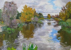
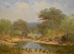
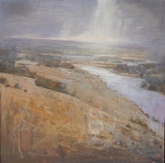
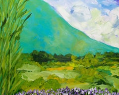
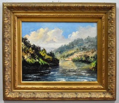
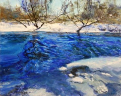
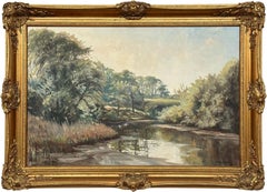
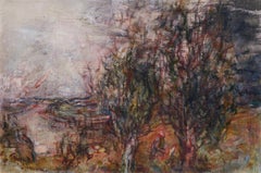
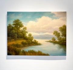
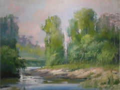
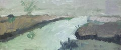
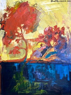
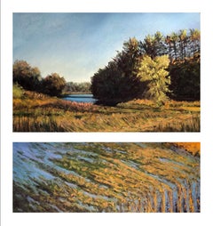
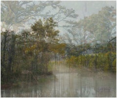
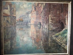
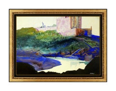
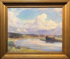
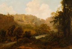
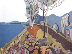
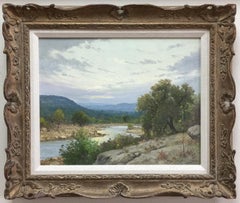
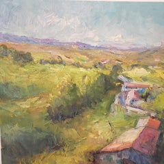
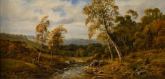
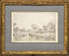
"Autumn. Irpin River"
By Nataliia Loza
Located in Edinburgh, GB
The painting depicts a bend in the river framed by autumn trees in shades of yellow.
Category
21st Century and Contemporary Landscape Paintings
Materials
Canvas, Oil
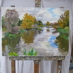
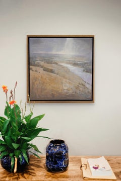
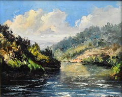
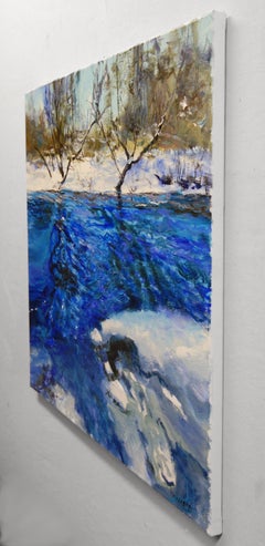
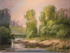
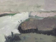
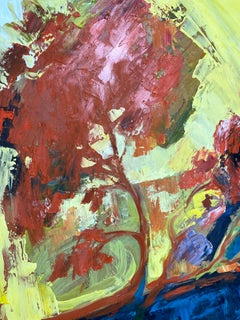
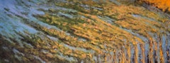
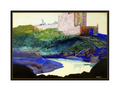
"Autumn. Irpin River"
By Nataliia Loza
Located in Edinburgh, GB
The painting depicts a bend in the river framed by autumn trees in shades of yellow.
Canvas, Oil
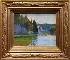
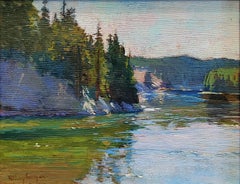
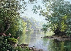
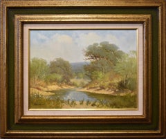
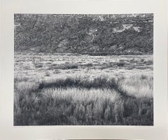
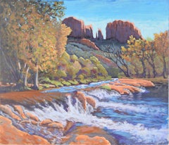
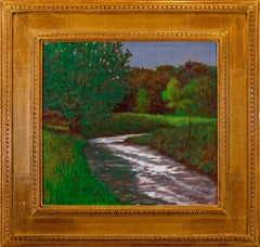
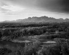
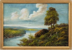
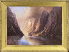
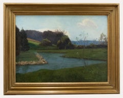
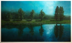
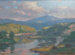
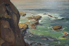
Bend in the River, Yellowstone
By Richard Humphrey
Located in Pasadena, CA
Provenance Acquired by the gallery directly from the artist Signed "R. Humphrey" on lower left Artist Statement "The glassy surface of the river almost seems calm. Below the gentle...
Canvas, Oil
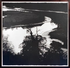

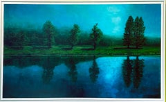
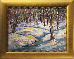
Bend in the RIver, Black and White
Located in New York, NY
It is under plexiStriking for anSarah Gillespie lives in Devon, England and works full-time as a painter, typically making tiny oil sketches outside in the summer months, and then ve...
Charcoal, Ink, Archival Paper

$9,300
H 20 in W 25 in
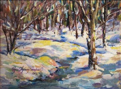
"A Gentle Bend in the River" — Circa 1920 Oil on Canvas French River Landscape
By René Charles Edmond His
Located in Naples, Florida
"A Gentle Bend in the River" by René Charles Edmond His (French, 1877–1960) is a circa 1920 oil on canvas landscape measuring 13 x 18 inches, depicting a serene river bordered by mat...
Oil, Canvas
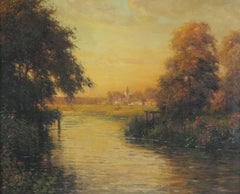
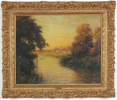
Twilight along the River Bend
By Louis Aston Knight
Located in Sheffield, MA
Louis Aston Knight New York/California/France, 1873-1948 Twilight along the River Bend Oil on canvas signed lower left"Aston Knight/Paris" 26 by 32 in.
Oil
$16,500
H 12 in W 16 in D 3 in
"BEND IN THE CREEK" G. HARVEY TEXAS LANDSCAPE RIVER CREEK
By G. Harvey
Located in San Antonio, TX
Harvey (Gerald Harvey Jones) (1933-2017) San Antonio, Austin, and Fredericksburg Artist Image Size: 12 x 16 Frame Size: 21 x 25 Medium: Oil on Canvas Signed Lower Left "Bend In The ...
Oil
$5,750
H 38 in W 57 in D 0.1 in
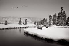
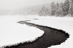
Two bison standing at a river’s bend in winter in this ethereal, beautiful black
By Drew Doggett
Located in US
"Season of Stillness" Two bison standing at a river’s bend in winter in this ethereal, beautiful black and white image Calming, surreal black and white image of two bison standing ...
Archival Pigment
River's Bend, Mixed Media on Other
By Tiffani Buteau
Located in Yardley, PA
"River's Bend" is a captivating addition to Tiffani's evocative series, "Flowing Forms: The Erosive Dance of Water."
Mixed Media
$1,800
H 12 in W 12 in
"Bend of the River" (2025), Original Midwestern Landscape, Oil Painting
By Andrzej Skorut
Located in Denver, CO
Andrzej Skorut's "Bend of the River" is an impressive landscape oil painting piece which rests at 12 x 12 inches on stretched canvas, and is framed at 13.5 x 13.5 inches ready to han...
Oil
River's Bend, Painting, Acrylic on Canvas
By Allan P Friedlander
Located in Yardley, PA
I am inspired by the area I live in California. The hills are alive with beauty in the spring. I hope the viewer can feel that excitement from this painting from the way it has been...
Acrylic

$1,495
H 12 in W 17 in
Pocahontas, Just Around the River Bend: Limited Edition Hand-Painted Cel
By Walt Disney Studio Artists
Located in Los Angeles, CA
The limited edition cel titled "Just Around the River Bend" was taken from Sequence 5, Scene 25.
Paint, Paper, Pencil

$536
H 20.28 in W 26.78 in
Howard Gull Stormont (1844-1923) - Framed Watercolour, View from the River Bend
Located in Corsham, GB
A fine watercolour painting by the artist Howard Gull Stormont (1844-1923). The scene depicts an atmospheric view across a still river with sheep grazing under an autumnal oak. The w...
Watercolor
$8,289
H 74.81 in W 66.93 in D 1.58 in
River Bend - Large Format Contemporary Nature Painting, Landscape
By Aleksandra Batura
Located in Salzburg, AT
Aleksandra Batura (b. 1982 in Augustów) a Warsaw based artist. She earned a Doctor of Fine Arts degree from the Academy of Fine Arts in Cracow. She studied at the Faculty of Painting...
Crayon, Cotton Canvas, Ink, Oil
"RIVER BEND" OIL ON CANVAS APPLIED BY PALETTE KNIFE
By Jose Vives-Atsara
Located in San Antonio, TX
Jose Vives-Atsara (1919-2004) San Antonio Artist Image Size: 16 x 20 Frame Size: 25 x 28.75 Medium: Oil on Canvas Applied by Palette Knife "River Bend" Biography Jose Vives-Atsara (1...
Oil


Follow the Bend, Original Painting
By Brit J Oie
Located in San Francisco, CA
Outside the studio, she enjoys hiking, gardening, relaxing in outdoor hot springs, and taking in the river view.Words that describe this painting: river, road, mountain, texture, val...
Mixed Media
$1,950
H 8 in W 10 in
Janine Robertson "Blue Bend", 8x10 Luminous Rocky River Green Marsh Landscape
By Janine Robertson
Located in Saratoga Springs, NY
The use of aluminum as a substrate often allows for a unique luminosity, as the metal can reflect light back through the layers of oil paint, enhancing the "glow" of the water and sk...
Metal
Ripples at the Bend, Oil Painting
By Onelio Marrero
Located in San Francisco, CA
Words that describe this painting: river, ripples, snow, stream, forest, trees, landscape, woods, ice, winter, water, cold, New Jersey, impressionism, nature, representational, oil p...
Oil
$9,250
H 36 in W 48 in
Craig Mooney, "River Bend", 36x48 Marsh Landscape Oil Painting on Canvas
By Craig Mooney
Located in Saratoga Springs, NY
This dreamlike piece, "River Bend", is a 36x48 oil painting on canvas by artist Craig Mooney depicting a shimmering river in the late afternoon hours, snaking through the bends of l...
Canvas, Oil

$2,396
H 25 in W 35 in D 3 in
Vintage Oil Painting of a Tree-Lined River Landscape in the Irish Countryside
By Allan Ardies
Located in Preston, GB
A gentle play of light bathes the landscape in golden tones, filtering through trees that bend softly toward their reflections in the river.
Canvas, Oil
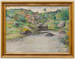
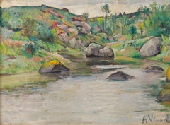
Andre-Leon Vivrel (1886-1976) - Mid 20th Century Oil, River Bend
Located in Corsham, GB
Signed to the lower right. Presented in a gilt frame. On board.
Oil
$1,700
H 20 in W 24 in D 0.1 in
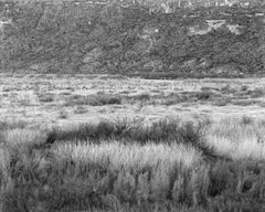
River Bottom Near Santa Elena, Big Bend by Jack Ridley, 2012, Photography
By Jack Ridley
Located in Denton, TX
River Bottom Near Santa Elena, Big Bend by Jack Ridley is a black and white archival pigment print.
Archival Pigment
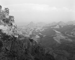
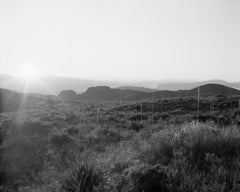
View from the South Rim, Big Bend
By Jack Ridley
Located in Denton, TX
"At least twice a year, Ridley ventures to Big Bend with his 8 x 10 view camera capturing stunning, expansive black and white images of the Rio Grande River, including the Chisos Mou...
Archival Pigment
$164,349
H 20.01 in W 37.25 in
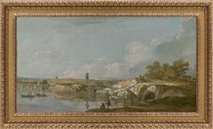
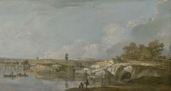
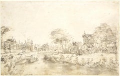
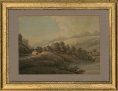
The Valley of the River Severn with a distant view of Shrewsbury
By Richard Wilson
Located in London, GB
The flat, sun-drenched landscape captures the bend in a large river, crossed by a five arch stone bridge in the middle distance, with a town shown on the horizon.
Canvas, Oil
$5,200
H 60 in W 24 in
Creek Bend, Sister Bay - Blue Cloudy Skies Over River, Original Oil Painting
By Ahzad Bogosian
Located in Chicago, IL
Ahzad Bogosian Creek Bend, Sister Bay acrylic on canvas 60h x 24w in 152.40h x 60.96w cm Framed Dimensions 61h x 25w x 2d in 154.94h x 63.50w x 5.08d cm AZB154 Ahzad Bogosian SOLO ...
Acrylic
$2,800Sale Price|20% Off
H 25 in W 36.75 in D 1.5 in
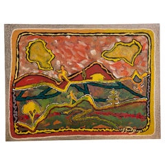
At the Bend - Abstracted Russian Landscape by Yuri Gusev
By Yuri Gusev
Located in Soquel, CA
At the Bend - Abstracted Russian Landscape Yuri Gusev Impressionist landscape of a river at the edge of the woods by Yuri Gusev (Russian, b. 1928).
Linen, Oil
$2,350
H 24 in W 36 in D 0.1 in
Landscape of a river winding through a winter tundra in dramatic black and white
By Drew Doggett
Located in US
"Continuum" Landscape of a river winding through a winter tundra in dramatic black and white Black and white, ethereal portrait of a perfect bend in the river in winter in Yellowst...
Archival Pigment
$1,720Sale Price|20% Off
H 36 in W 42 in D 0.25 in
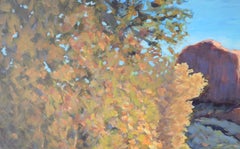
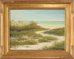
River in the Desert - Western Plein Aire Landscape in Acrylic on Board
By Nick White
Located in Soquel, CA
The viewer stands at the edge of a bright blue river with a small waterfall. Just past the bend in the river, there are lush trees and shrubs, some with yellowing leaves, indicating ...
Acrylic, Board
$1,700
H 8 in W 10 in D 2 in
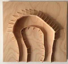
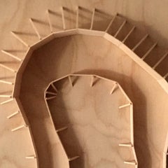
Fritz Horstman, Formwork for a Deep Bend, 2016, Wood, Plywood
By Fritz Horstman
Located in Darien, CT
While working on a large building project several years ago the artist, Fritz Horstman was struck by the poetry in the unfinished state of the construction site. He was drawn specifi...
Wood, Plywood


Take Me to the River 12
By Ruth Adler
Located in New York, NY
ABOUT THIS PIECE: Color is the foundation of my work. My circles start as a mood or idea that eventually evolves into a colored circle. I am curious how different colours interact wh...
Photographic Paper


Take Me to the River 11
By Ruth Adler
Located in New York, NY
ABOUT THIS PIECE: Color is the foundation of my work. My circles start as a mood or idea that eventually evolves into a colored circle. I am curious how different colours interact wh...
Photographic Paper


Take Me to the River 13
By Ruth Adler
Located in New York, NY
ABOUT THIS PIECE: Color is the foundation of my work. My circles start as a mood or idea that eventually evolves into a colored circle. I am curious how different colours interact wh...
Photographic Paper


Take Me to the River 10
By Ruth Adler
Located in New York, NY
ABOUT THIS PIECE: Color is the foundation of my work. My circles start as a mood or idea that eventually evolves into a colored circle. I am curious how different colours interact wh...
Photographic Paper


Take Me to the River 9
By Ruth Adler
Located in New York, NY
ABOUT THIS PIECE: Color is the foundation of my work. My circles start as a mood or idea that eventually evolves into a colored circle. I am curious how different colours interact wh...
Photographic Paper
George Ames Aldrich Cottage On A River
By George Ames Aldrich
Located in Dallas, TX
In Indiana, he added Juday Creek and the St. Joseph River near South Bend to his narrowing repertoire of landscape subjects, still dominated by the romantic French village images he ...
Paint

$8,700
H 36 in W 48 in D 1.5 in
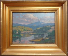
Creek Meets River: Hudson River School Landscape Painting of Water and Mountains
By Jane Bloodgood-Abrams
Located in Hudson, NY
Modern Luminist, Hudson River School landscape painting on canvas of a creek and river meeting around a forest bend with mountains in the distance "Where Creek Meets River" by Jane B...
Oil, Panel
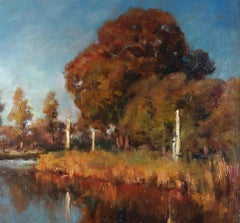
"Morning on Buck Run Bend"
By Peter Sculthorpe
Located in Lambertville, NJ
Jim’s of Lambertville is proud to offer this artwork. Signed lower right. Complemented by a hand carved and gilt frame. Peter Sculthorpe (b. 1948) Peter Sculthorpe was born in O...
Canvas, Oil
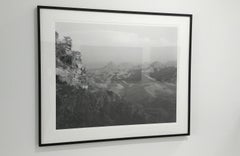
Sunrise from Pine Canyon, Big Bend
By Jack Ridley
Located in Denton, TX
"At least twice a year, Ridley ventures to Big Bend with his 8 x 10 view camera capturing stunning, expansive black and white images of the Rio Grande River, including the Chisos Mou...
Archival Pigment
$4,200
H 27.63 in W 17.75 in
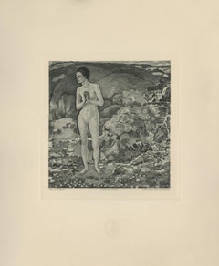
"Woman at the River's Edge" Copper Plate Heliogravure
By Ferdinand Hodler & R. Piper & Co.
Located in Palm Beach, FL
2018 marks the centenary anniversary of Ferdinand Hodler’s death. In that 100 years time, the art world’s esteem of this important artist has proved fickle. It has shifted from extol...
Paper
Swift River
By Jennifer Nehrbass
Located in Bozeman, MT
Jennifer Nehrbass is a painter living and working in Albuquerque, New Mexico. She was born in West Bend, Wisconsin in 1970. She received her B.S. in Art and Textile Design from the U...
Oil, Wood

$392
H 19.89 in W 26.38 in
H. Montgomerie - Early 20th Century Watercolour, Autumnal Haze On The River
Located in Corsham, GB
An atmospheric Autumnal landscape showing a bend in a river with stark trees and bull rushes at the bank, shrouded in haze.
Watercolor
$1,850
H 12 in W 17.25 in
'New York, View of the East River', Paris, Metropolitan Museum, Smithsonian
By Max Pollak
Located in Santa Cruz, CA
Signed lower right, 'Max Pollak' (American, 1886-1970) with number and limitation, lower center, '21/150' and titled, lower left, 'New York: East River'. Published by Rudolph Lesch a...
Paper, Etching

$4,500
H 36 in W 36 in
Zum Schwarzen Ferkel - (The Black Piglet) Vibrant Scene of a Group in a Bar
By Benjamin Duke
Located in Chicago, IL
., University of Utah, Salt Lake City, UT 2001 Summer School of Music and Art, Yale University, New Haven, CT Selected Exhibitions 2023 Ben Duke & Suk Ja Kang: New Work, Gallery Vi...
Canvas, Oil
$2,500
H 18 in W 18 in D 1.5 in
Dusk at Bayou Bend MFAH Texas Landscape Oil Impressionism Buffalo Bayou
By Steve Parker
Located in Houston, TX
FREE SHIPPING Dusk at Bayou Bend is contemporary oil landscape painting on canvas that is 18" x 18".Dusk at Bayou Bend was painted in 2026 by Texan artist Steve Parker The locat...
Canvas, Oil
$480
H 11.13 in W 18.25 in
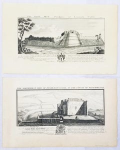
"Pendragon Castle" and "Lincoln Castle" from "Buck's Antiquities" /// British UK
By Samuel & Nathaniel Buck
Located in Saint Augustine, FL
Pendragon Castle is a ruin located in Mallerstang Dale, Cumbria, south of Kirkby Stephen, and close to the hamlet of Outhgill (at grid reference NY781025). It stands above a bend in ...
Laid Paper, Engraving, Intaglio
Trees in the Field
Located in Fairlawn, OH
A Resource Guide to the Visual Arts of Afro- Americans, South Bend, Ind., 1971. NEW YORK (NY). Acts of Art, Inc.
Mixed Media
$6,000
H 30 in W 40 in D 1.5 in
Sunset at Bayou Bend #2 MFAH Texas Landscape Oil Impressionism Buffalo Bayou
By Steve Parker
Located in Houston, TX
Bayou Bend was painted in 2022 by Texan artist Steve Parker .
Canvas, Oil
$1,700
H 20 in W 24 in D 0.1 in
Punta de la Sierra and Rio Grande, Loop Camp, Big Bend
By Jack Ridley
Located in Denton, TX
"At least twice a year, Ridley ventures to Big Bend with his 8 x 10 view camera capturing stunning, expansive black and white images of the Rio Grande River, including the Chiso...
Archival Pigment

$4,500
H 16.54 in W 25.2 in D 1.97 in
Late Summer River Landscape / - Realistic Impression -
By Jan Hillebrand Wijsmüller
Located in Berlin, DE
Where the river begins to bend, the water is churned by a rapids.
Canvas
$712Sale Price|20% Off
H 6 in W 13.5 in
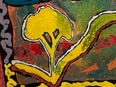
French Expressionist Abstract Oil Painting - River Landscape
By Yvette Dubois Habasque
Located in Cirencester, Gloucestershire
Abstract, by Yvette Dubois-Habasque (1929-2016) oil painting on artists paper, unframed painting measures: 6 x 13.5 inches Stunning original abstract painting by the French artist,...
Oil
$1,776Sale Price|50% Off
H 22.64 in W 32.49 in
Sidney Richard Percy (British master) - Romantic 19th century river scene
By Sidney Richard Percy
Located in Varmo, IT
The painting depicts a bend in a river surrounded by summer greenery. In the foreground, on the right bank, a rock emerges from grass and flowering shrubs beside a tall tree with den...
Canvas, Oil
$4,000
H 36 in W 36 in
The Miracle #3 (Hands), A Personal Delusional Solution - Ben Duke
By Benjamin Duke
Located in Chicago, IL
., University of Utah, Salt Lake City, UT 2001 Summer School of Music and Art, Yale University, New Haven, CT Selected Exhibitions 2023 Ben Duke & Suk Ja Kang: New Work, Gallery Vi...
Canvas, Oil
$4,500
H 31 in W 41 in
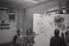
Unruly Muse - Allegorical Drawing of the Artist in The Studio with Models
By David Becker
Located in Chicago, IL
Alberta College of Art, Alberta, Canada Albion College, Albion, MI Alma College, Alma, MI Art Center, South Bend, IN AT&T Corporate HQ, Plainfield, NJ Boston Printmakers, Boston, MA ...
Charcoal, Archival Paper

$575Sale Price|20% Off
H 12.75 in W 16.75 in D 1 in
Mid-20th Century Post-Impressionist Watercolor of River Scene with Boat
By Anne Marie Migette Perard
Located in Cirencester, Gloucestershire
The scene’s tranquility is underscored by the mirror-like reflections on the river’s surface and the gentle bend of the trees lining the riverbank.
Watercolor


$5,409
H 26.5 in W 46.5 in D 2 in
Pair - Ornately framed Oval English River Flower Scenes with Swans, Cows, Sheep
Located in Preston, GB
In the left composition, the eye follows the gentle bend of the river toward a distant cottage and a scatter of grazing animals, the sky filled with soft summer clouds.
Canvas, Oil, Cotton, Wood, Paint
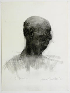
Scorn, charcoal on paper, portrait of a male in profile
By David Becker
Located in Chicago, IL
Alberta College of Art, Alberta, Canada Albion College, Albion, MI Alma College, Alma, MI Art Center, South Bend, IN AT&T Corporate HQ, Plainfield, NJ Boston Printmakers, Boston, MA ...
Charcoal, Archival Paper
"Dance of the wind"
Located in Edinburgh, GB
“Dance of the Wind” is an expressive painting that portrays trees bending gracefully over a river, their reflections rippling across the water like shifting memories.
Canvas, Oil

$1,400
H 11 in W 14 in
We Will Build Our Dreams and Then Live in Them #2, Two Figures & a Sailboat
By Benjamin Duke
Located in Chicago, IL
., University of Utah, Salt Lake City, UT 2001 Summer School of Music and Art, Yale University, New Haven, CT Selected Exhibitions 2017 Distortion, Gallery Victor Armendariz, Chica...
Oil, Panel
Unavailable
H 3.59 in W 2.56 in
Set of 2 prints: A ship's wharf & A bend in the river with a ship.
By Cornelis Ploos van Amstel
Located in Zeeland, Noord-Brabant
2 Printdrawings on laid paper. A printdrawing is a work of art made to simulate a drawing, using a combination of graphical techniques including roulette, mezzotint, crayon / stipple...
Engraving, Mezzotint, Etching, Aquatint
Bend in the River, Allagash
By Henry Isaacs
Located in Boothbay Harbor, ME
Henry Isaacs Cranberry Island artist Henry Isaacs paints with energy, passion, and self-assurance. His style—broken brushwork and a palette of delicate blues, greens, pinks, and yell...
Canvas, Oil
Along the Muddy River
By Kim Goldfarb
Located in Asheville, NC
This mixed media/collage painting portrays the figure of a woman standing in front of a abstracted backdrop of mud and earth. The woman is self assured and yet serene despite the tor...
Board, Mixed Media, Oil
River Park I, Diptych
Located in Portland, ME
Pastels with a "glitter" to them make this sky-water-grasses scene as special in a frame as it was in life. The imagined bottom "half" brings attention to the sounds of the rushing w...
Paper, Pastel

Unavailable
H 20 in W 24 in
Three Years out of a Death Row Sentence (River) 20 x 24 Inch, 2009-2016
By Amy Elkins
Located in Orange, CA
She works primarily in photography and installation and has been exhibited and published both nationally and internationally, including at The High Museum of Art in Atlanta, GA; Sout...
Archival Pigment

Unavailable
H 30 in W 45 in
Three Years out of a Death Row Sentence (River) 30 x 45 Inch, 2009-2016
By Amy Elkins
Located in Orange, CA
She works primarily in photography and installation and has been exhibited and published both nationally and internationally, including at The High Museum of Art in Atlanta, GA; Sout...
Archival Pigment

Unavailable
H 20 in W 30 in
Eleven Years out of a Death Row Sentence (River) 20 x 30 Inch, 2009-2016
By Amy Elkins
Located in Orange, CA
She works primarily in photography and installation and has been exhibited and published both nationally and internationally, including at The High Museum of Art in Atlanta, GA; Sout...
Archival Pigment

Unavailable
H 40 in W 60 in
Eleven Years out of a Death Row Sentence (River) 40 x 60 Inch, 2009-2016
By Amy Elkins
Located in Orange, CA
She works primarily in photography and installation and has been exhibited and published both nationally and internationally, including at The High Museum of Art in Atlanta, GA; Sout...
Archival Pigment

Unavailable
H 30 in W 45 in
Thirteen Years out of a Death Row Sentence (River) 30 x 45 Inch, 2009-2016
By Amy Elkins
Located in Orange, CA
She works primarily in photography and installation and has been exhibited and published both nationally and internationally, including at The High Museum of Art in Atlanta, GA; Sout...
Archival Pigment

Unavailable
H 40 in W 60 in
Thirteen Years out of a Death Row Sentence (River) 40 x 60 Inch, 2009-2016
By Amy Elkins
Located in Orange, CA
She works primarily in photography and installation and has been exhibited and published both nationally and internationally, including at The High Museum of Art in Atlanta, GA; Sout...
Archival Pigment
Unavailable
H 20 in W 30 in
Thirteen Years out of a Death Row Sentence (River) 20 x 30 Inch, 2009-2016
By Amy Elkins
Located in Orange, CA
She works primarily in photography and installation and has been exhibited and published both nationally and internationally, including at The High Museum of Art in Atlanta, GA; Sout...
Archival Pigment
Unavailable
H 30 in W 45 in
Eleven Years out of a Death Row Sentence (River) 30 x 45 Inch, 2009-2016
By Amy Elkins
Located in Orange, CA
She works primarily in photography and installation and has been exhibited and published both nationally and internationally, including at The High Museum of Art in Atlanta, GA; Sout...
Archival Pigment
Unavailable
H 40 in W 60 in
Three Years out of a Death Row Sentence (River) 40 x 60 Inch, 2009-2016
By Amy Elkins
Located in Orange, CA
She works primarily in photography and installation and has been exhibited and published both nationally and internationally, including at The High Museum of Art in Atlanta, GA; Sout...
Archival Pigment

Unavailable
H 66.01 in W 68.01 in
Sunrise at Gila Bend, Acrylic, spray-paint, photo transfer, and oil and enamel
Located in London, GB
Rosson Crow creates densely layered panoramas on a massive scale. Incorporating everything from shop aisles and neon signage to discarded beer cans and bumper stickers, her work is d...
Acrylic

Ancient Passage
Located in Cincinnati, OH
One of the premier experiences for river runners is the anticipation of discovery that lies around the next bend.
Linen, Oil

The Spin of Life
Located in East Patchogue, NY
Oil painting on canvas stretched on a wooden frame, Signed by the artist. Horseshoe Bend, Antelope canyon, AZ Delphine Rocher is a graduate of the Duperré School of Applied Arts, Pa...
Oil
Unavailable
H 33.08 in W 41.74 in
"OUDE VAART TE GENT / THE OLD CITY OF GHENT, BELGIUM"
Located in Ghent, BE
The spectator gets lured in, really feels immerged in the setting, but when it comes to finding out what is around the bend … well, I suggest taking a boat ride on the river.
Oil
Unavailable
H 30 in W 40 in D 0.75 in
Landscape Oil Painting #2 by Clifford Kluge
Located in Pasadena, CA
The eye crosses hills, paths, and rivers, pausing on humans in motion. One figure climbs a ridge, another walks a trail; their outlines echo the curves of the hills, the fork of a tr...
Oil, Mixed Media
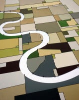
Curvature
By William Steiger
Located in New York, NY
In Curvature, Steiger offers an abstracted aerial view of a river bend, including subtle shadows for the trees lining the river in a gray blue tone.
Linen, Oil


Unavailable
H 24 in W 42 in D 4 in
Photorealist painting, "Brown Perspective with Freckles" enamel on aluminum
By Jerry Ott
Located in Binghamton, NY
From the height of Jerry Ott's career, "Brown Perspective with Freckles" is a mind bending optical illusion. From one vantage point the image appears to be a man peering through bino...
Metal, Enamel
Unavailable
H 22 in W 30.5 in
John Whorf Large Watercolor Painting Original Landscape Signed Framed Artwork
By John Whorf
Located in Bloomington, MN
This watercolor painting, titled "Original River Bend" looks absolutely spectacular in person with the custom and high-quality moulding enhancing the exquisite imagery.
Watercolor

Sold
H 16.93 in W 21.26 in
Donald Henry Floyd (1892-1965) - Early 20th Century Oil, Rocky River
Located in Corsham, GB
A dramatic river scene in oil showing the sparkling water of a river rushing and swirling over rocks at a bend in the river.
Oil

1871 Watercolour - Fly Fishing
Located in Corsham, GB
A pretty rural watercolour scene showing a church on a bend in the river with swans swimming and cattle grazing.
Watercolor

A Bend in the Seine
By William Jurian Kaula
Located in Milford, NH
A beautiful French landscape painting of a bend on the Seine River attributed to American artist William Jurian Kaula (1871-1953).
Canvas, Oil

River Bend Study
By John MacDonald
Located in Westport, CT
Traditional landscape, traditional art, tranquil, river, reflection, trees, forest, nature, season, water, blue, green, purple, lavender, Jean-Baptiste-Camille Corot, John Francis Mu...
Linen, Oil, Wood Panel
H. Seargant - Late 19th Century Oil, Bend In The River
Located in Corsham, GB
A fine Victorian landscape showing a bend in a sparkling river with a woodland path curving with the water at the right bank.
Oil
Sold
H 24 in W 36 in D 3 in
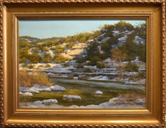
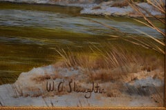
"BEND IN THE CREEK" TEXAS HILL COUNTRY LIMESTONE BLUFFS RIVER 33 X 45 FRAMED
Located in San Antonio, TX
W. A. Slaughter (1923 - 2003) Dallas / San Antonio Artist Image Size: 24 x 36 Frame Size: 33 x 45 Medium: Oil on Canvas "Bend in the Creek" Texas Hill Country Biography W. A. Slaught...
Oil


Sold
H 38 in W 38 in
Craig Mooney "River Bend" Atmospheric River Sunset Landscape Oil Painting, 2020
By Craig Mooney
Located in Saratoga Springs, NY
Craig Mooney's "River Bend" is a 38x38 oil painting on canvas of a river winding through a dark green forest landscape with golden sunset clouds that are reflected by the water.
Canvas, Oil

Sold
H 18.98 in W 30.24 in
Paul Mann (1907-1994) - 20th Century Watercolour, A Bend in the Thames
By Paul Mann
Located in Corsham, GB
An atmospheric watercolour painting by the British artist Paul Mann, depicting a river scene. Signed to the lower right-hand corner. The title is inscribed to the opposite corner. Th...
Watercolor
Sold
H 24.81 in W 32.68 in
James Baker Pyne (1800-1870) - Mid 19th Century Oil, Cottage on the River Bend
By James Baker Pyne
Located in Corsham, GB
A fine country landscape by Bristol artist James Baker Pyne. The painting captures a serene rural scene with rolling hills, lush foliage, and a winding river in the foreground. The a...
Oil

The River
Located in Boston, MA
Artist Commentary: Original Painting on Silk Keywords: river, water, nature, trees, blue, color Artist Biography: Irina Dorofeeva is a silk artist living in South Bend, IN.
Silk, Dye

Sold
H 19 in W 23 in D 3 in
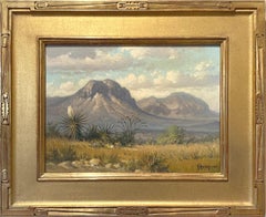
"Springtime In the Chisos" West Texas Mountains Big Bend
By G. Harvey
Located in San Antonio, TX
G. Harvey (Gerald Harvey Jones) (1933-2017) San Antonio, Austin, and Fredericksburg Artist Image Size: 12 x 16 Frame Size: 18 x 22 Medium: Oil Dated 1970 "Springtime In the Chisos" W...
Oil
Sold
H 19.69 in W 23.63 in
Warta river bend - Waterscape Landscape Oil Painting, Realistic, Polish artist
By Janusz Szpyt
Located in Warsaw, PL
Janusz Szpyt was born in 1960, he is a Polish painter. He graduated from the Graphic design faculty and painting from the Academy of Fine Arts in Krakow. 1983 onward, he became the m...
Canvas, Oil
Landscape with a River
Located in Boston, MA
Keywords: landscape, Volga River, Russia, silk painting Artist Biography: Irina Dorofeeva is a silk artist living in South Bend, IN.
Silk, Dye
Ocotillo After the Rain, Big Bend Area
By Jim Stoker
Located in Dallas, TX
Texas artist Jim Stoker has developed his Confetti/Splatter technique of painting over the past 15 years to convey nature in a non-photographic way. Stoker creates a rich tapestry o...
Linen, Oil

English School c.1900 Oil - The River in Spring
Located in Corsham, GB
A charming landscape study depicting the bend of a river on a calm spring day. The artist shows the body of water situated between peaceful meadows and woodland.
Oil
"Dusty Bend, South Carolina"
By Jean H. Halter
Located in Lambertville, NJ
Jim’s of Lambertville is proud to offer this artwork by: Jean Halter (1915 - 1981) Jean Halter was a self-taught primitive artist who lived in New Hope. She was born in Pittsburgh ...
Oil

" Guadalupe Bend " Texas Hill Country Scene
By Porfirio Salinas
Located in San Antonio, TX
Porfirio Salinas "Guadalupe Bend" Guadalupe River (1910-1973) San Antonio Artist Image Size: 16 x 20 Frame Size: 22.5 x 26.5 Medium: Oil "Guadalupe Bend" Porfirio Salinas was ...
Oil
Whiskey River
By Jennifer Nehrbass
Located in Bozeman, MT
This is a unframed oil painting. Jennifer Nehrbass is a painter living and working in Albuquerque, New Mexico. She was born in West Bend, Wisconsin in 1970. She received her B.S. in ...
Canvas, Oil

"Sierra Del Carmen" Big Bend Texas West Texas
By G. Harvey
Located in San Antonio, TX
Harvey (Gerald Harvey Jones) (1933-2017) San Antonio, Austin, and Fredericksburg Artist Image Size: 20 x 24 Frame Size: 28 x 32 Medium: Oil Dated 1966 "Sierra del Carmen" (Mountain...
Oil
Rare Heavy Rain Causes Ocotillo Bloom, Big Bend, Texas
By Jim Stoker
Located in Dallas, TX
Texas artist Jim Stoker began developing his confetti-splatter technique of painting in 2000 to depict his interpretations of the unique flora along the Guadalupe River, as well as t...
Linen, Oil

Sold
H 24 in W 36 in D 3 in
"BIG BEND NATIONAL PARK" TEXAS OIL APPLIED BY PALETTE KNIFE FRAMED 33 X 45
By Jose Vives-Atsara
Located in San Antonio, TX
Jose Vives-Atsara (1919-2004) San Antonio Artist Image Size: 24 x 36 Frame Size: 33 x 44.5 Medium: Oil on Canvas Applied by Palette Knife Dated 1995 "Big Bend National Park" Texas Bi...
Oil


Sold
H 23.5 in W 21.5 in
19th-Century Danish School, River Landscape With Cottage, Antique Oil Painting
Located in Cheltenham, GB
An ancient tree towers above it, leaning across a bend in the mossy river. The inhabitants live off the land and use a small boat to navigate the waterway.
Oil, Canvas


Sold
H 47 in W 92 in
Very Large Hand Woven Wool Tapestry "Boulders II" River Stones
By Julia Mitchell
Located in Surfside, FL
Julia Mitchell Wool on Linen Tapestry, Boulders II Signed and dated JM 82 Julia Mitchell’s Biography Julia grew up in a family of artists, adopting tapestry as a means of expression...
Wool, Linen
Sold
H 24 in W 30 in D 1.5 in
Un Pueblo en España, A Village in Spain, Tonalist , oil , Spain Landscape
By Marty Ricks
Located in Houston, TX
Life to me feels very much like a river, wherein strong currents and lazy meanderings carry us along.
Oil


The Gossips
By L. Clarence Ball
Located in Missouri, MO
His specialty was landscapes with cattle and sheep, primarily around South Bend and the Kankakee River as well as Diamond Lake in Michigan where he spent his summers.
Canvas, Oil
Sold
H 30 in W 24 in
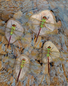
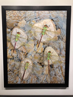
Rocks in the Current - Original Photorealist Painting of Dragonflies Atop Stones
By Rick Pas
Located in Chicago, IL
Four brightly colored green dragonflies sit atop river stones as water gently moves beneath their transparent wings.
Acrylic, Panel
Sold
H 14.77 in W 26.78 in
Henry Turner - Framed Late 19th Century Oil, Waiting for the Bite
By Henry Turner Munns
Located in Corsham, GB
An atmospheric landscape painting depicting two figures fishing on the bend of a gentle river. The artist has signed the composition in the lower left, and the oil has been well pres...
Oil


Sold
H 72 in W 48 in D 1.5 in
Year of the Eclipse - Original Oil Painting of Fictional Oversized Book Cover
By Don Pollack
Located in Chicago, IL
Rundquist, “remembering beauty: the seductive & nostalgic nature of ameri - can landscape”, (Catalogue), South Bend Regional Art Museum, South Bend, Indiana, August 8-October 4, 1998...
Canvas, Oil
Sold
H 63.5 in W 88 in
The Gospel - Large Scale Vivid Color Surreal Urban Scene, Original Oil on Canvas
By Benjamin Duke
Located in Chicago, IL
., University of Utah, Salt Lake City, UT 2001 Summer School of Music and Art, Yale University, New Haven, CT Selected Exhibitions 2023 Ben Duke & Suk Ja Kang: New Work, Gallery Vi...
Canvas, Oil


Sold
H 30 in W 20 in D 1.5 in
Calculus, Original Trompe L'oeil Painting of Classic Text Book With a Red Tulip
By Don Pollack
Located in Chicago, IL
Rundquist, “remembering beauty: the seductive & nostalgic nature of ameri - can landscape”, (Catalogue), South Bend Regional Art Museum, South Bend, Indiana, August 8-October 4, 1998...
Canvas, Oil

Sold
H 7 in W 4 in D 4 in
"ATOMIC AVOVADO VASE" 1949 One of Texas & the World's Master Glazers MID CENTURY
By Harding Black
Located in San Antonio, TX
In 1931 Black joined an archaeological expedition to the Big Bend area sponsored by the Witte Memorial Museum.
Ceramic
Sold
H 7.69 in W 12.19 in
Villas on the Brenta, an ink wash on paper by Francesco Guardi, Venice 1712-1793
By Francesco Guardi
Located in PARIS, FR
In the middle of the canal the Burchiello advances. It was a river boat with a large wooden cabin, finely painted and decorated and lit by windows on each side.
Paper, Ink


Sold
H 11 in W 14 in
We Will Build Our Dreams and Then Live in Them - Figurative and Landscape
By Benjamin Duke
Located in Chicago, IL
., University of Utah, Salt Lake City, UT 2001 Summer School of Music and Art, Yale University, New Haven, CT Selected Exhibitions 2017 Distortion, Gallery Victor Armendariz, Chica...
Oil, Panel
Sold
H 36 in W 60 in
Coeur d'Alenes Trail - Serene Landscape in Rich Greens and Blues, Oil on Canvas
By Don Pollack
Located in Chicago, IL
Rundquist, “remembering beauty: the seductive & nostalgic nature of ameri - can landscape”, (Catalogue), South Bend Regional Art Museum, South Bend, Indiana, August 8-October 4, 1998...
Canvas, Oil

Late 18th Century Watercolour - Rural Village
Located in Corsham, GB
A late-18th to early-19th century view of a rural village situated at a bend in a river. A horse can be seen towing a boat from the riverbank at the left of the composition.
Watercolor
$1,150
H 12.25 in W 15.25 in D 1 in
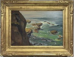
"Southern Beach" Coastal Landscape in Oil on Canvas
By Max Flandorfer
Located in Soquel, CA
"Southern Beach" Coastal Landscape in Oil on Canvas Oil painting of the a beach landscape by Max Flandorfer (American, b. 1962). A sandy path winds towards the beach through some gr...
Oil, Canvas
$3,200Sale Price|20% Off
H 13.5 in W 16.5 in D 2.5 in
Landscape Farm Oil painting John C Traynor Salmagundi Club Auction Mt Ascutny
Located in Chesterfield, NJ
John C Traynor Mt Ascutny oil/linen 9 x 12 image unframed, 13.5 x 16.5 framed signed LR Purchased at the Salmagundi Club in 2003. This is one of two of Johns earlier paintings I was...
Oil
Winter Landscape
Located in San Francisco, CA
This artwork titled "Winter Landscape" 2002 is an oil painting on hardboard by American artist Royce Thyberg Gordon, 1938-2021. It is signed and dated at the lower left corner by the...
Oil
$12,000Sale Price|20% Off
H 19.5 in W 25.5 in D 3 in
California Impressionist Oil Painting Franz A. Bischoff Laguna Seascape
Located in Chesterfield, NJ
Franz Arthur Bischoff seascape Laguna Tide Pools oil/board signed LR in a gilt over red clay bole and gesso carved Arts & Crafts style frame. 13 x 19 unframed, 19.5 x 25.5 framed s...
Oil
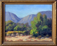
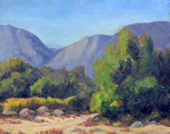
1930's California Mountain Trail Landscape
By Sidney L. Brock
Located in Soquel, CA
A beautiful 1930's landscape titled "Trail into California Mountains" by Oklahoman artist Sidney Lorenzo Brock (American, 1869-1943). Presented in a rustic giltwood frame. Signed "Si...
Linen, Oil
$2,500
H 22.75 in W 26.75 in D 1.5 in
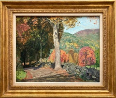
"Autumn" Colorful Mid-20th Century American Oil Painting Landscape with Tress
Located in New York, NY
A wonderful depiction of an Autumn landscape in Kent, Connecticut from the Mid-20th Century with puffed trees by the country side. For this beautiful depiction, we find distinct elem...
Oil, Board, Canvas

$775
H 18 in W 22 in D 2 in
Vintage American Impressionist Framed New England Farm Landscape Oil Painting
Located in Buffalo, NY
Oil on canvas, 18 x 22 inches overall, 16 x 20 inches image size. Vintage American impressionist landscape painting. Oil on canvas. Framed.
Canvas, Oil

$695
H 16 in W 22 in D 2 in
Vintage American Impressionist Signed Landscape Original Framed Oil Painting
Located in Buffalo, NY
Vintage American impressionist landscape oil painting. Oil on board. Signed. Framed. Provenance from a Sag Harbor, NY collection. Measuring: 16 by 22 inches overall. Handsomely fram...
Oil, Board
$1,995
H 29.5 in W 35.5 in D 0.75 in
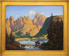
1950s Western Mountain Landscape Oil Painting "Little Bear" Framed Art
By Harold Vincent Skene
Located in Denver, CO
"Little Bear" is a captivating mid-century oil painting by American artist Harold Vincent Skene (1883–1978). This traditional Western landscape, painted in the 1950s, features a stri...
Oil
$4,720Sale Price|20% Off
H 16.75 in W 19.75 in D 1.25 in
Roy Henry Brown NA American Impressionist Landscape Oil Painting 1879-1956
By Roy Henry Brown
Located in Chesterfield, NJ
Roy Henry Brown Trees and Rocks Mountain side image sight size 10 x 13 and 16.75 x 19.75 framed as is pictured in original frame as purchased. signed LR. A landscape mountain hill...
Oil

$8,500
H 29 in W 33 in D 2 in
Antique American Pennsylvania Impressionist Framed Landscape Rare Oil Painting
Located in Buffalo, NY
Rare antique oil painting by Charles W. Patterson (1870 - 1938) . Oil on canvas, signed lower right. Measuring 29 x 33 inches overall, 22 x 27 inches image size. Nicely framed.
Canvas, Oil
$21,600Sale Price|20% Off
H 33 in W 38 in
Landscape Painting by Arvid Nyholm, Impressionist, Swedish American, Chicago
Located in Grand Rapids, MI
Arvid Frederick Nyholm (Swedish-American, 1866-1937) Signed: A Nyholm (Lower, Right and Lower, Left) " Mother and Child in a Landscape ", circa 1910-1920 Oil on Canvas 25" x 30"...
Canvas, Oil

Signed Antique American Impressionist Framed Landscape Oil Painting
Located in Buffalo, NY
Charles Sutton, “April Afternoon,” Oil on Board, Framed Landscape Painting Warmly toned impressionist oil painting by Charles Sutton, titled April Afternoon. The work captures a tra...
Canvas, Oil
$14,000Sale Price|20% Off
H 19 in W 23.5 in D 2.75 in
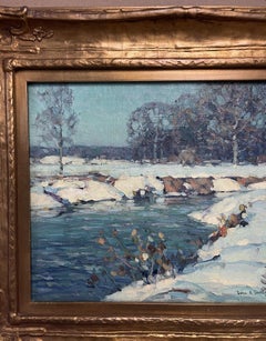
American Impressionist Woodstock Artist John F Carlson Oil Painting Snow
By John F Carlson
Located in Chesterfield, NJ
Wintry Pool oil on canvas 12 x 16 image size Signed LR when viewing the painting and again verso, on back. Image measures 12 x 16 The painting is in good condition in a period gilded...
Oil
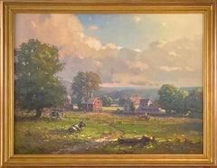
"New England Farm, " Landscape Oil Painting
By John C. Traynor
Located in Westport, CT
This large landscape oil painting by John Traynor captures a scene in New England. Cows are visible in front of a long picket fence, with a red barn and house behind the fence and lu...
Oil, Canvas

$1,400Sale Price|20% Off
H 28 in W 32 in D 2 in
Antique American Impressionist Upstate New York Landscape Framed Oil Painting
By George Renouard
Located in Buffalo, NY
Antique American impressionist oil painting of a fall landscape by George A. Renouard (American, 1884-1954). Oil on board. Signed. Framed.
Canvas, Oil