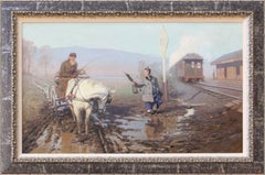
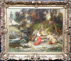
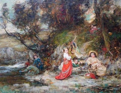
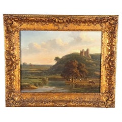
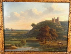
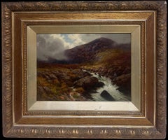
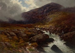
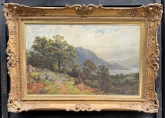
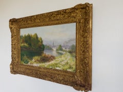
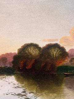
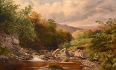
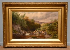
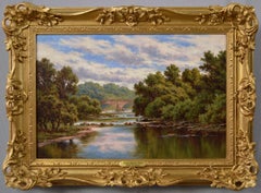
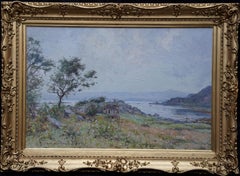
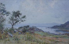
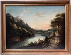
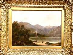
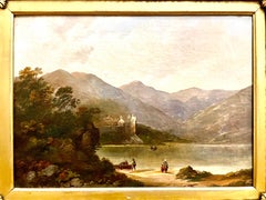
Train Map

2
155
6
to
19
109
47
161
157
157
11
4
3
1
1
1
1
1
1
1
62
26
67
6
12
48
5
5
3
4
21
7
9
7
1
2
129
19
10
7
6
80
28
22
20
20
12
2
2
2
2
Sort By
Original Vintage Poster Chemins De Fer Railway Express Train Map Art Deco Design
Located in London, GB
) depicting a steam train speeding over a silhouette map of France in the background with flying wings as
Category

Vintage 1930s French Art Deco Posters

Materials

Paper

Antique Map of Persia with Dedication Cartouche
Located in Langweer, NL
Antique map titled 'Persia sive Sophorum Regnum'. Original old map of Persia. The map extends from
Category

Antique Mid-17th Century Maps

Materials

Paper

Antique Map of Persia with Dedication Cartouche
Free Shipping
H 20.01 in W 24.02 in D 0.02 in
Curaçao map - C. van Baarsel en zoon
Located in UTRECHT, UT
his father opened a grocery store. There, the young Cornelis was also trained as a grocer, but he felt
Category

Antique 1810s Dutch Other Maps

Materials

Paper

Curaçao map - C. van Baarsel en zoon
H 21.86 in W 27.56 in D 0.79 in
1908 "Map of Texas" by The Kenyon Company
Located in Colorado Springs, CO
station agent at once for rates. Join our Train at Kansas City. FREE BERTHS." The map is artfully
Category

Antique Early 1900s American Maps

Materials

Paper

Colorful Detailed Antique Map of England and Wales, 1882
Located in Langweer, NL
Explore the Historic Splendor of 'England and Wales' with this Antique Map! Part of a distinguished
Category

Antique 1880s Maps

Materials

Paper

Antique Map of present-day North-Rhine Westphalia, Germany
Located in Langweer, NL
Antique map titled 'Nova et Accurata Ducatus Cliviae et Comitatus Marchiae (..)'. Detailed regional
Category

Antique Mid-18th Century Maps

Materials

Paper

Antique Map of Drenthe, the Netherlands, with Original Hand Coloring
Located in Langweer, NL
Original antique map titled 'Illustribus ac Potentibus Comitatus Drentiae (..)'. Old map of the
Category

Antique Mid-17th Century Maps

Materials

Paper

Original Antique Map of Peru with Regions Outlined in Color
Located in Langweer, NL
Antique map titled 'Carte du Pérou'. This map of Peru and the surrounding region shows excellent
Category

Antique Early 19th Century Maps

Materials

Paper

Plan of Paris, France, by A. Vuillemin, Antique Map, 1845
Located in Colorado Springs, CO
This large and detailed plan of Paris was published by Alexandre Vuillemin in 1845. The map conveys
Category

Antique 1840s American Maps

Materials

Paper

Antique Map of Western and Eastern Barbary in Africa, c.1744
Located in Langweer, NL
Antique map titled 'A New & Accurate Map of the Western Parts of Barbary' and 'A New & Accurate Map
Category

Antique 18th Century Maps

Materials

Paper

Antique Map of Guinea in West Africa by Blaeu, c.1638
Located in Langweer, NL
Antique map titled 'Guinea'. Decorative map of West Africa, including numerous animals in the
Category

Antique 17th Century Maps

Materials

Paper

1643 Willem&Joan Blaeu Map NW Flanders "Flandriae Teutonicae Pars Prientalior
Located in Norton, MA
1643 Willem and Joan Blaeu map of northwest Flanders, entitled "Flandriae Teutonicae Pars
Category

Antique 17th Century Dutch Maps

Materials

Paper

Antique Map of Macedonia by the Famous Mapmaker Blaeu, c.1650
Located in Langweer, NL
Antique map titled 'Macedonia, Epirus et Achaia'. Ornated with a nice allegoric cartouche, one
Category

Antique 17th Century Maps

Materials

Paper

Antique Map of the Circle of Bavaria by Homann, c.1703
Located in Langweer, NL
Antique map titled 'Bavariae circulus et electorat (..)'. Map of the Circle of Bavaria, Germany
Category

Antique 18th Century Maps

Materials

Paper

Scandinavia & Portions of Eastern Europe: 18th Century Hand-Colored Homann Map
By Johann Baptist Homann
Located in Alamo, CA
An early 18th century hand-colored copper-plate map entitled "Regni Sueciae in omnes suas
Category

Antique Early 18th Century German Maps

Materials

Paper

Antique Map of the Circle of Franconia by Homann, c.1703
Located in Langweer, NL
Antique map titled 'Circuli Franconiae pars Occidentalis, exhibes simul integrum fere Electoratum
Category

Antique 18th Century Maps

Materials

Paper

Antique Map of the Circle of Franconia by Homann, c.1703
Located in Langweer, NL
Antique map titled 'Circuli Franconiae pars Occidentalis, exhibes simul integrum fere Electoratum
Category

Antique 18th Century Maps

Materials

Paper

Original Antique Map of Utrecht in the Netherlands by Blaeu, C.1645
Located in Langweer, NL
Antique map titled 'Ultraiectum Dominium'. Old map of the province of Utrecht, the Netherlands
Category

Antique 17th Century Maps

Materials

Paper

Antique Map of Macedonia, Northern Greece and part of Turkey in Europe
Located in Langweer, NL
Antique map titled 'Macedonia Epirus et Achaia'. Original old map of Macedonia, northern Greece
Category

Antique Mid-17th Century Maps

Materials

Paper

Original Detailed Antique Map of Southern India and Most of Ceylon, 1744
Located in Langweer, NL
Antique map titled 'A Map of India on the west Side of the Ganges, comprehending the coasts of
Category

Antique 1740s Maps

Materials

Paper

Colourful Antique Map Centered on Nuremberg and Bamberg in Germany, ca.1703
Located in Langweer, NL
Antique map titled 'Circuli Franconiae pars Occidentalis, exhibes simul integrum fere Electoratum
Category

Antique Early 1700s Maps

Materials

Paper

Antique Map of Southeast Asia from Persia to the Timor Island, 1712
Located in Langweer, NL
Antique map titled 'A New Map of the East Indies'. Old map covering all of Southeast Asia from
Category

Antique 1710s Maps

Materials

Paper

Map of the Duchy Clivia & Ravestein, Brabant in The Netherlands & Germany, 1635
Located in Langweer, NL
Antique map titled 'Clivia Ducatus et Ravestein Dominium.' Map of the Duchy Clivia and
Category

Antique 1630s Maps

Materials

Paper

Map of East Friesland, The Netherlands & the Area Emden & Norden, Germany, 1635
Located in Langweer, NL
Antique map titled 'Typus Frisiae Orientalis.' Map of East Friesland and the area around Emden
Category

Antique 1630s Maps

Materials

Paper

Original Antique Map of the Dutch Provinces of Overijssel and Drenthe, 1635
Located in Langweer, NL
Antique map titled 'Transiselania Dominium vernacule Over-Yssel.' - Map of the Dutch Provinces of
Category

Antique 1630s Maps

Materials

Paper

London 1744 Published Watercolour Antique Map of East Africa by Eman Bowen
Located in GB
We are delighted to offer for sale this New and Accurate Map of Nubia & Abissinia, together with
Category

Antique 1740s English George III Maps

Materials

Paper

Hand-Colored 18th Century Homann Map of the Danube, Italy, Greece, Croatia
By Johann Baptist Homann
Located in Alamo, CA
"Fluviorum in Europa principis Danubii" is a hand colored map of the region about the Danube river
Category

Antique Early 18th Century German Maps

Materials

Paper

Antique Map of Dutch & Belgium Provinces Limburg, Namen and Ardennes, ca.1635
Located in Langweer, NL
Antique print, titled: 'Leodiensis Dioecesis.' Detailed map including the Dutch and Belgium
Category

Antique 1630s Maps

Materials

Paper

West Africa Entitled "Guinea Propria": An 18th Century Hand Colored Homann Map
By Johann Baptist Homann
Located in Alamo, CA
This is a scarce richly hand colored copper plate engraved map of Africa entitled "Guinea Propria
Category

Antique Mid-18th Century German Maps

Materials

Paper

18th Century Hand-Colored Homann Map of Germany, Including Frankfurt and Berlin
By Johann Baptist Homann
Located in Alamo, CA
An 18th century hand-colored map entitled "Tabula Marchionatus Brandenburgici et Ducatus Pomeraniae
Category

Antique Early 18th Century German Maps

Materials

Paper

Antique Map of Oceania and the Pacific Ocean, Australia and New Zealand, 1826
Located in Langweer, NL
Antique map of Australia titled 'Karte von Australien'. Old map of Australia and New Zealand
Category

Antique 19th Century Maps

Materials

Paper

Original Antique Map of Zuid-Holland in the Netherlands by Blaeu, C.1645
Located in Langweer, NL
Antique map titled 'Zuydhollandia stricte sumta'. Old map of the province of Zuid-Holland, the
Category

Antique 17th Century Maps

Materials

Paper

Antique Map of India as Described It Was before the 5th Century, 1744
Located in Langweer, NL
Antique map titled 'India, as described by all Authors before the fifth Century'. Detailed map of
Category

Antique 18th Century Maps

Materials

Paper

Antique Map of 'African' Islands in the Mediterranean Sea and The Atlantic, 1747
Located in Langweer, NL
Antique map titled 'Particular draughts of some of the chief African Islands in the Mediterranean
Category

Antique 18th Century Maps

Materials

Paper

Sweden & Adjacent Portions of Scandinavia: A Hand-Colored 18th C. Map by Homann
By Johann Baptist Homann
Located in Alamo, CA
This hand-colored map of Sweden and adjacent portions of Scandinavia entitled "Regni Sueciae in
Category

Antique 1720s German Maps

Materials

Paper

Hand Colored 18th Century Homann Map of Austria Including Vienna and the Danube
By Johann Baptist Homann
Located in Alamo, CA
"Archiducatus Austriae inferioris" is a hand colored map of Austria created by Johann Baptist
Category

Antique Early 18th Century German Maps

Materials

Paper

Antique Map of Asia Minor, showing Turkey, Cyprus and the Islands in the Aegean
Located in Langweer, NL
Antique map titled 'Natolia, quae olim Asia Minor'. Decorative map of Asia Minor, showing Turkey
Category

Antique Mid-17th Century Maps

Materials

Paper

Old Map Covering All of Southeast Asia from Persia to the Timor Island, 1712
Located in Langweer, NL
Description: Antique map titled 'A New Map of the East Indies'. Old map covering all of Southeast
Category

Antique 1710s Maps

Materials

Paper

The Kingdom of Naples and Southern Italy: A Hand-Colored 18th Century Homann Map
By Johann Baptist Homann
Located in Alamo, CA
hand colored map of southern Italy and the ancient Kingdom of Naples created by Johann Baptist Homann
Category

Antique Early 18th Century German Maps

Materials

Paper

Hand-Colored 18th Century Homann Map of the Black Sea, Turkey and Asia Minor
By Johann Baptist Homann
Located in Alamo, CA
An attractive original early 18th century hand-colored map of the Black Sea and Turkey entitled
Category

Antique Early 18th Century German Maps

Materials

Paper

Hand-Colored 18th Century Homann Map of Denmark and Islands in the Baltic Sea
By Johann Baptist Homann
Located in Alamo, CA
An 18th century copper plate hand-colored map entitled "Insulae Danicae in Mari Balthico Sitae
Category

Antique Early 18th Century German Maps

Materials

Paper

Antique Map of Artois in the North of France by Famous Mapmaker Blaeu, c.1640
Located in Langweer, NL
Antique map titled 'Artesia Comitatus Artois'. Map of Artois or Artesia, France. Artois is former
Category

Antique 17th Century Maps

Materials

Paper

Original Blaeu Map of Southeast Asia from India to Tibet and Japan to New Guinea
Located in Langweer, NL
Antique map titled 'India quae Orientalis dicitur et Insulae Adiacentes'. Beautiful map of
Category

Antique 1640s Maps

Materials

Paper

Original Vintage Travel By Train London Town Pictorial Map Poster Kerry Lee
By Kerry Lee
Located in London, GB
Original vintage Travel By Train map poster for London Town by the British artist, illustrator and
Category

Vintage 1950s British Posters

Materials

Paper

1640 Flandriae Partes Duae Quarum Altera Proprietaria, Ric0016
Located in Norton, MA
1640 Willem and Joan Blaeu map entitled "Flandriae Partes duae quarum altera Proprietaria, altera
Category

Antique 17th Century Dutch Maps

Materials

Paper

Plan for the City of Washington by Andrew Ellicott, Antique Print, 19th Century
Located in Colorado Springs, CO
Ellicott. L'Enfant was born in Paris, where he trained to be an architect. He came to America in 1777
Category

Antique Late 19th Century American Maps

Materials

Paper

Pair of Floor Standing Globes by Gilman Joslin
By Gilman Joslin
Located in Lymington, Hampshire
(1804-1886) trained as a wood turner and looking-glass make. He went to work for pioneering Boston globe
Category

Antique 19th Century American Maps

Materials

Iron

Original Vintage Poster London Town Pictorial Map Southern Railway Underground
By Kerry Lee
Located in London, GB
Original vintage Travel By Train map poster for London Town by the British artist, illustrator and
Category

Vintage 1930s British Posters

Materials

Paper

Original Vintage Poster Pictorial Map Of Yorkshire British Railways Train Travel
Located in London, GB
Original vintage train travel poster - Pictorial Map of Yorkshire by British Railways - featuring a
Category

Vintage 1950s British Posters

Materials

Paper

Original Vintage Railway Travel Poster Weymouth GWR SR Railway Map Express Train
Located in London, GB
Original vintage railway travel poster advertising Weymouth and District Frequent Express Trains
Category

Vintage 1940s British Posters

Materials

Paper

Original Vintage Poster SZD Travel On Soviet Railways Trains USSR Map Design
Located in London, GB
on the trains of the Soviet railways! - featuring a conductor waving to the viewer from an open door
Category

Vintage 1960s Russian Posters

Materials

Paper

Original Vintage Train Travel Map Poster Isle Of Man British Railways UK Manx
Located in London, GB
Original vintage travel map poster for the Isle of Man issued by British Railways in conjunction
Category

Vintage 1950s British Posters

Materials

Paper

Original Vintage Rail Travel Map Poster France Map SNCF National French Railway
Located in London, GB
Original vintage rail travel map poster - France Societe Nationale des Chemins de Fer Francais
Category

Vintage 1950s French Posters

Materials

Paper

Original Vintage Train Travel Poster Bourgogne Burgundy Wine SNCF Railway France
Located in London, GB
Original vintage train travel poster for Bourgogne / Burgundy issued by the National Society of
Category

Vintage 1930s French Posters

Materials

Paper

1750 Schaffhausen, Seutter, Large and Detailed Map Switzerland
By Matthew Seutter
Located in Norwich, GB
) was the most famous artist in Germany. He trained in engraving and painting and travelled extensively
Category

Antique 1670s Italian Baroque Prints

Materials

Paper

Antique Vintage Australia Wall Map By W & A K Johnston
By W. & A.K. Johnston
Located in Stockbridge, GB
Vintage Australia Wall Map By W & A K Johnston A vintage school pull down wall map of Australia
Category

Mid-20th Century British Schoolhouse Posters

Materials

Canvas, Wood

1679 Sandrart Joachim, Von, Map of Ancient Rome, Italy
By Giovanni Battista Falda
Located in Norwich, GB
) was the most famous artist in Germany. He trained in engraving and painting and travelled extensively
Category

Antique 1670s Italian Baroque Prints

Materials

Paper

Original Vintage Travel Poster Rhodesia Pictorial Map Southern Africa Zimbabwe
Located in London, GB
Original vintage travel poster - A Pictorial Map of Rhodesia (Southern & Northern) - featuring a
Category

Vintage 1930s British Posters

Materials

Paper

American Election Map and 1960 Presidential Fact Sheet, Published 1960
Located in Langweer, NL
: 1960 (dated) Color: Printed Color Size: 24.9 x 17.9 inches (63.2 x 45.5 cm) This colorful map of
Category

Vintage 1960s Posters

Materials

Paper

Original Vintage Map Poster Marruecos Espanol Spanish Morocco Illustrated Design
Located in London, GB
Original vintage travel map poster for Marruecos Espanol / Spanish Morocco featuring a great
Category

Vintage 1940s Spanish Art Deco Posters

Materials

Paper

  • 1
Get Updated with New Arrivals
Save "Train Map", and we’ll notify you when there are new listings in this category.

Train Map For Sale on 1stDibs

With a vast inventory of beautiful furniture at 1stDibs, we’ve got just the train map you’re looking for. Each train map for sale was constructed with extraordinary care, often using paper, wood and paint. There are 105 variations of the antique or vintage train map you’re looking for, while we also have 4 modern editions of this piece to choose from as well. There are many kinds of the train map you’re looking for, from those produced as long ago as the 18th Century to those made as recently as the 21st Century. When you’re browsing for the right train map, those designed in Art Deco, mid-century modern and Baroque styles are of considerable interest. Many designers have produced at least one well-made train map over the years, but those crafted by Johann Baptist Homann, Leslie MacDonald Gill and Bain Studio are often thought to be among the most beautiful.

How Much is a Train Map?

The average selling price for a train map at 1stDibs is $1,525, while they’re typically $48 on the low end and $59,941 for the highest priced.