Items Similar to Antique Map of the Mouth of the Amu Darya River by Reclus, 1881

Want more images or videos?
Request additional images or videos from the seller
1 of 5
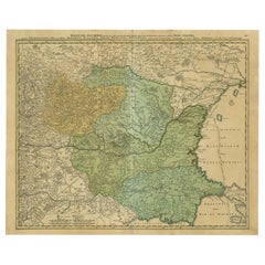
Antique Map of the Mouth of the Amu Darya River by Reclus, 1881
About the Item
Antique map titled 'Bouches de L'Amou - Daria'. Original antique map showing the river mouth of the Amu Darya river in Central Asia. This original old antique print / plate originates from: 'Nouvelle Geographie Universelle La Terre et les Hommes VI : L' Asie Russe' by Jacques Elisee Reclus. published in Paris by Hachette & Cie.. 1881.
Artists and Engravers: Jacques Elisee Reclus was a renowned French geographer. writer and anarchist. He produced his 19-volume masterwork La Nouvelle Geographie universelle. la terre et les hommes ('Universal Geography'). over a period of nearly 20 years (1875 � 1894).
Condition: Good. General age related toning and soiling. Please study image carefully.
Date: 1881
Overall size: 34.5 x 26.5 cm.
Image size: 29 x 22.5 cm.
We sell original antique maps to collectors, historians, educators and interior decorators all over the world. Our collection includes a wide range of authentic antique maps from the 16th to the 20th centuries. Buying and collecting antique maps is a tradition that goes back hundreds of years. Antique maps have proved a richly rewarding investment over the past decade, thanks to a growing appreciation of their unique historical appeal. Today the decorative qualities of antique maps are widely recognized by interior designers who appreciate their beauty and design flexibility. Depending on the individual map, presentation, and context, a rare or antique map can be modern, traditional, abstract, figurative, serious or whimsical. We offer a wide range of authentic antique maps for any budget
- Dimensions:Height: 10.44 in (26.5 cm)Width: 13.59 in (34.5 cm)Depth: 0 in (0.01 mm)
- Materials and Techniques:
- Period:
- Date of Manufacture:1881
- Condition:Condition: Good. General age related toning and soiling. Please study image carefully.
- Seller Location:Langweer, NL
- Reference Number:
About the Seller
5.0
Platinum Seller
These expertly vetted sellers are 1stDibs' most experienced sellers and are rated highest by our customers.
Established in 2009
1stDibs seller since 2017
1,929 sales on 1stDibs
Typical response time: <1 hour
- ShippingRetrieving quote...Ships From: Langweer, Netherlands
- Return PolicyA return for this item may be initiated within 14 days of delivery.
More From This SellerView All
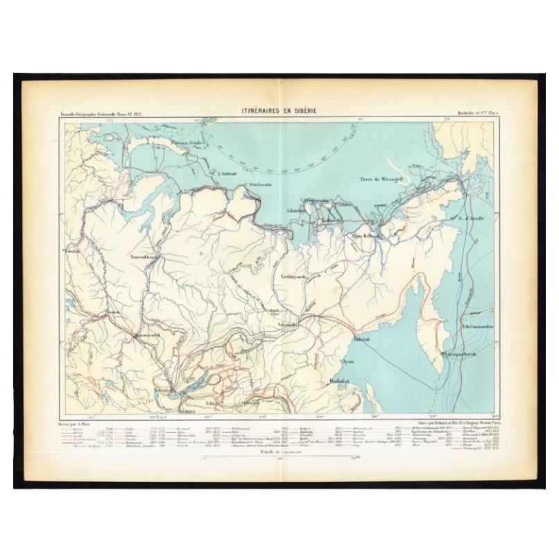
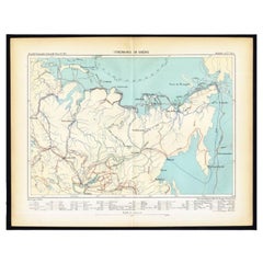
- Antique Map of Siberia by Reclus, 1881Located in Langweer, NLAntique map titled 'Itineraires en Siberie.' This map shows the itineraries of famous explorers in Siberia between 1648 and 1879. This original old antique print / plate originates f...Category
Antique 19th Century Maps
MaterialsPaper
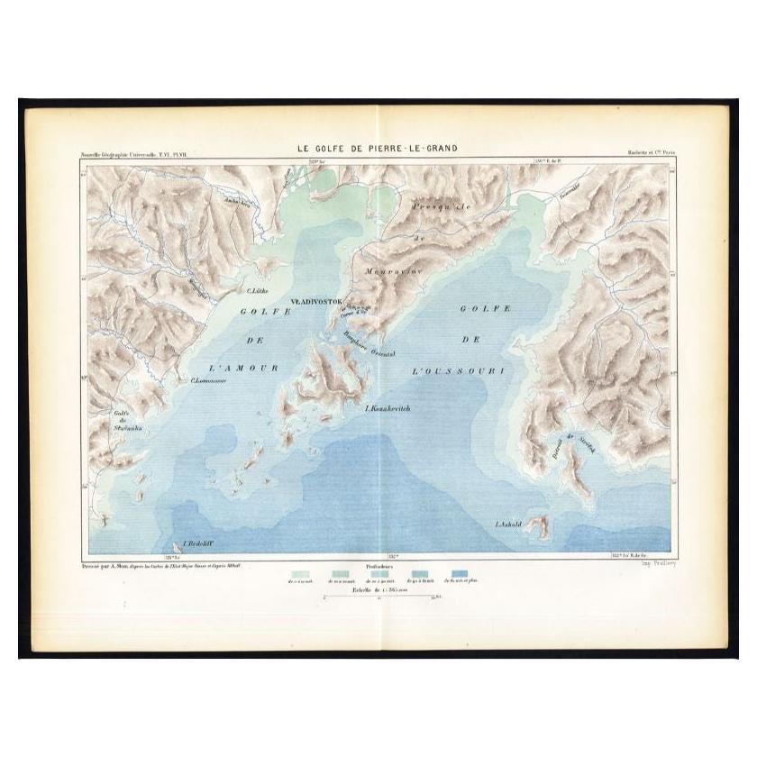
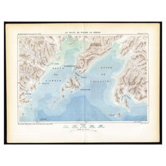
- Antique Map of the Peter the Great Gulf by Reclus, 1881Located in Langweer, NLAntique map titled 'Le Golfe de Pierre-Le-Grand.' This map shows the Peter The Great Gulf in the Sea of Japan adjoining the coast of Russia's Primorski...Category
Antique 19th Century Maps
MaterialsPaper
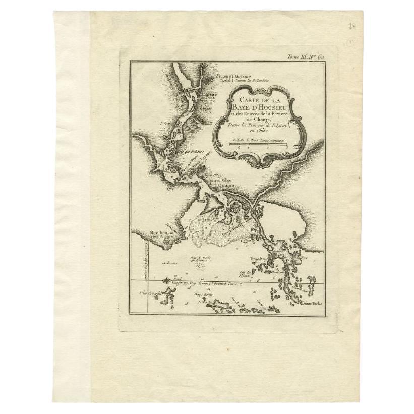
- Antique Map of the Mouth of the Chiang River by Bellin, 1764By Jacques-Nicolas BellinLocated in Langweer, NLAntique map titled ‘Carte de la Baye d'Hocsieu et des Entrees de la Riviere de Chang, Dans la Province de Fokyen en Chine’. This impressive map or sea chart d...Category
Antique 18th Century Maps
MaterialsPaper
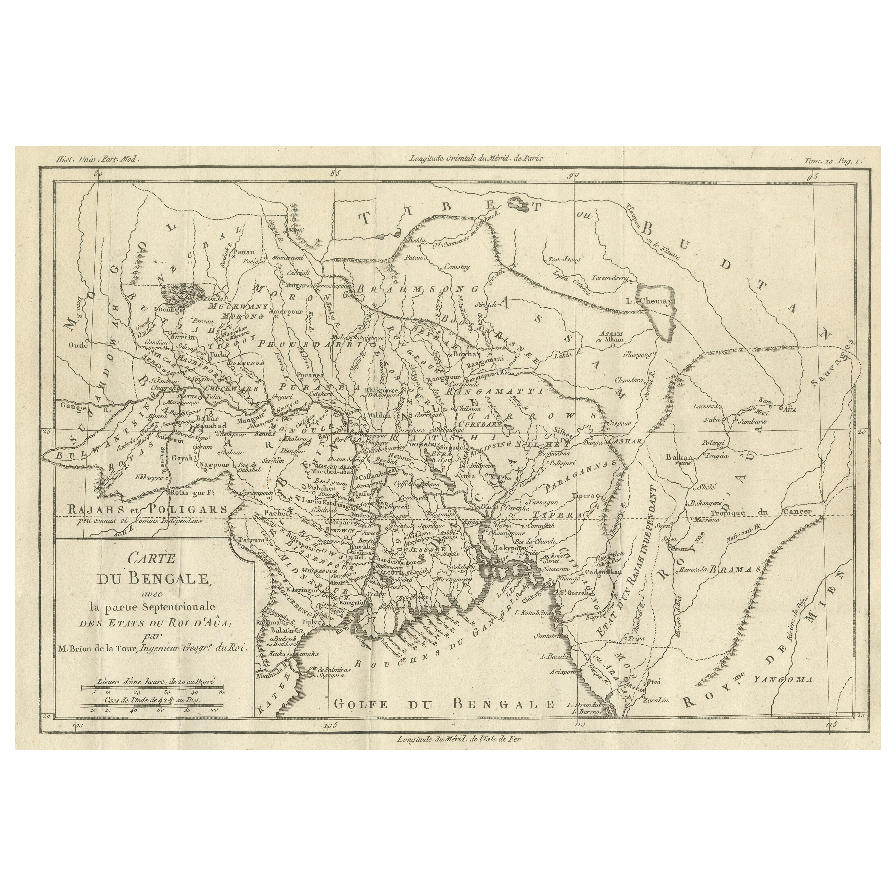
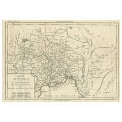
- Antique Map of of Bengal and the mouth of the Ganges RiverLocated in Langweer, NLAntique map titled 'Carte du Bengale, avec la partie Septentrionale (..)'. Original antique map of Bengal and the mouth of the Ganges river. This map ori...Category
Antique Late 18th Century Maps
MaterialsPaper
- Antique Map of the Mouth of the Yangtze River 'China' by J.N. Bellin, 1764Located in Langweer, NLThis detailed regional map of China is a historical cartographic work from the mid-18th century and is attributed to Antoine-François Prévost, a prominent French cartographer and geo...Category
Antique Mid-18th Century Maps
MaterialsPaper
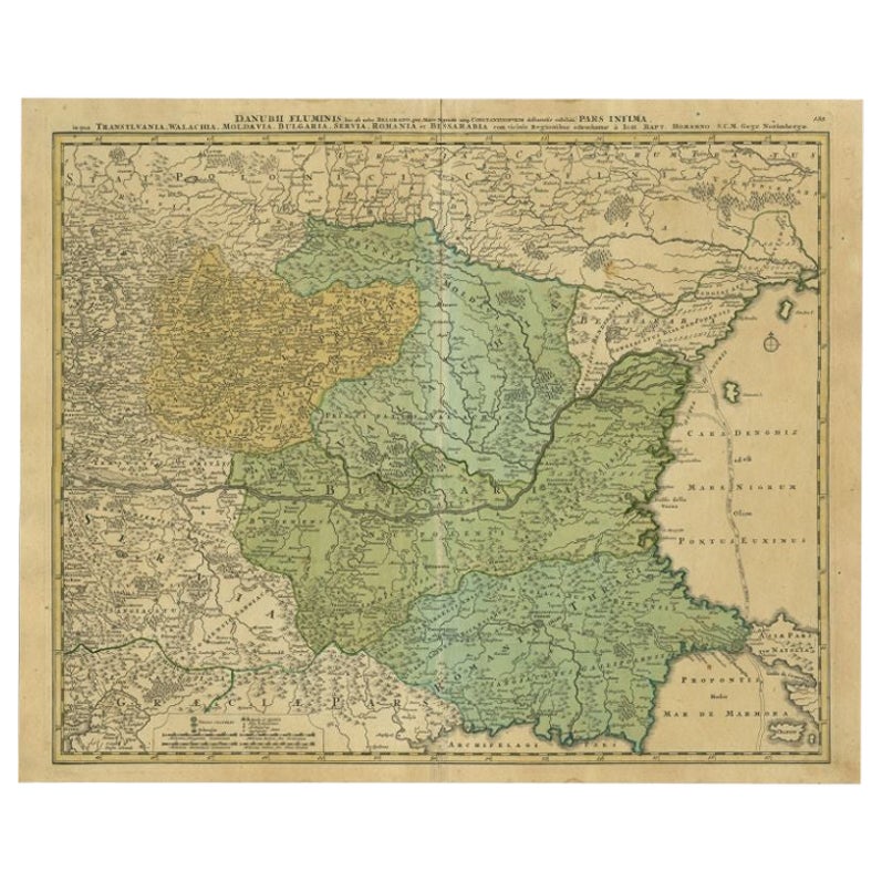
- Antique Map of the Danube River by Homann, c.1720By Homann HeirsLocated in Langweer, NLAntique map titled 'Danubii Fluminis (..)'. Regional map of the Donau river, Shows the Danube river from Belgrade in Serbia, along the border between Roma...Category
Antique 18th Century Maps
MaterialsPaper


You May Also Like
- Map "Estuary- Mouth of the Thames"Located in Alessandria, PiemonteST/426 - Antique French Map of the estuary of the Thames, map dated 1769 - "Mape of the entrance of the Thames. Designed by filing of Navy cards fo...Category
Antique Mid-18th Century French Other Prints
MaterialsPaper
- Antique Oarsman's Map of the River Thames, English, Cartography, Published 1912Located in Hele, Devon, GBThis is an antique copy of The Oarsman's and Angler's Map of the River Thames - New Edition. An English, bound map book, published in English by Edward Stanford, London, this new edi...Category
Early 20th Century British Other Books
MaterialsPaper
- 1861 Topographical Map of the District of Columbia, by Boschke, Antique MapLocated in Colorado Springs, COPresented is an original map of Albert Boschke's extremely sought-after "Topographical Map of the District of Columbia Surveyed in the Years 1856 ...Category
Antique 1860s American Historical Memorabilia
MaterialsPaper
- 1881 The Works of William ShakespeareBy William ShakespeareLocated in Bath, GBA superb limited edition set of the collected works of William Shakespeare, illustrated throughout by Sir John Gilbert. The collected works of William Shakespeare. A limited editio...Category
Antique 1880s British Books
MaterialsPaper
- Original Antique Map of The World by Thomas Clerk, 1817Located in St Annes, LancashireGreat map of The Eastern and Western Hemispheres On 2 sheets Copper-plate engraving Drawn and engraved by Thomas Clerk, Edinburgh. Published by Mackenzie And Dent, 1817 ...Category
Antique 1810s English Maps
MaterialsPaper
- 1907 Map of Colorado, Antique Topographical Map, by Louis NellLocated in Colorado Springs, COThis highly detailed pocket map is a topographical map of the state of Colorado by Louis Nell from 1907. The map "has been complied from all availabl...Category
Antique Early 1900s American Maps
MaterialsPaper


Recently Viewed
View AllMore Ways To Browse
Collectables From The 19 Century
La Terre
1894 Map
Old Asia Map
Asie Antique
Antique Print Central Asian
Antique Print Central Asia
Map Central Asia
Medieval Plate
Antique Depot
Kings Court
Large Framed Maps
Royal Carriage
Ships Log
Antique Map Australia
Australia Antique Map
Antique Australia Map
Antique Australian Map