Items Similar to Antique Map of the Amazon River and surroundings by Ogilby, c.1672


Want more images or videos?
Request additional images or videos from the seller
1 of 5
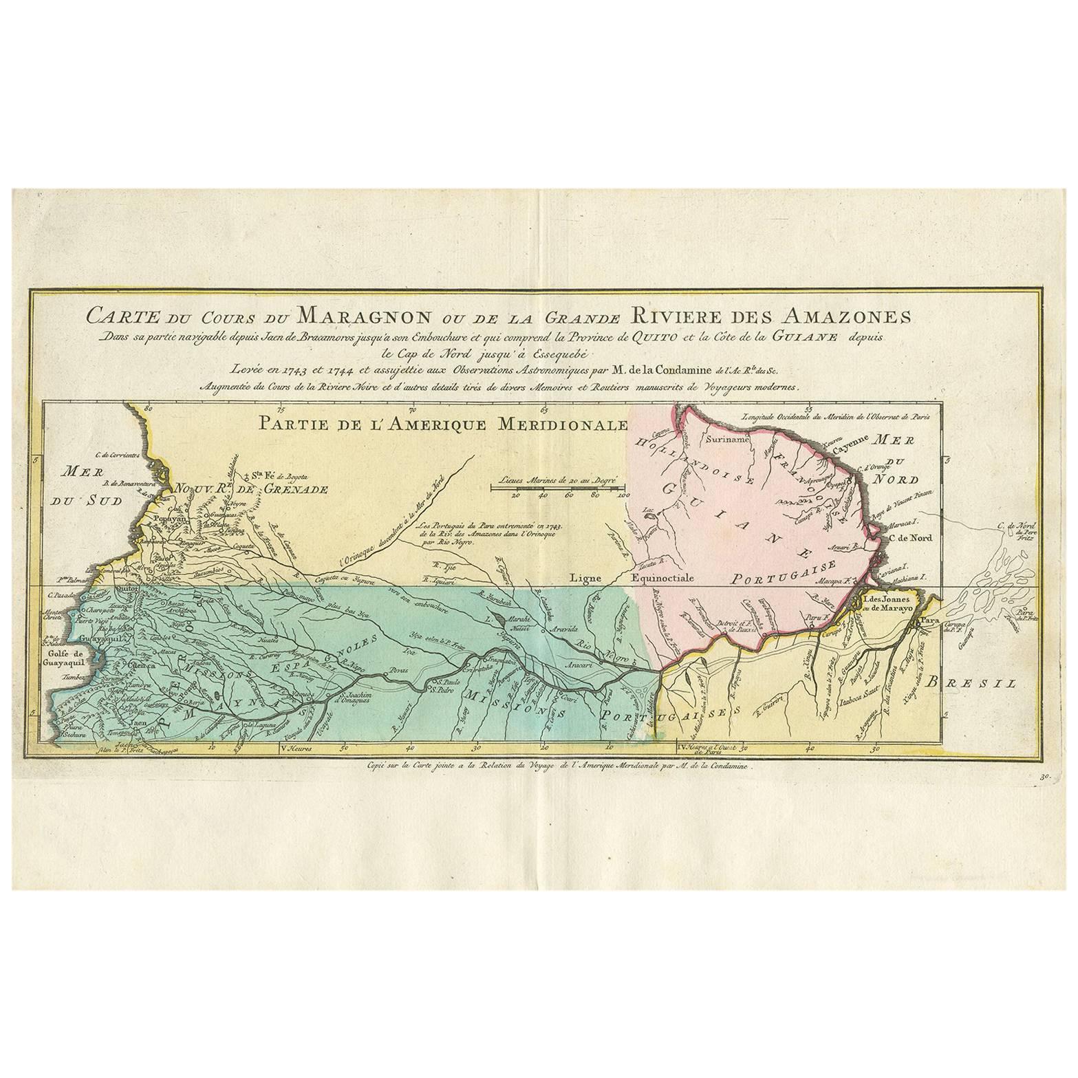
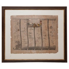
Antique Map of the Amazon River and surroundings by Ogilby, c.1672
About the Item
Antique map titled 'Guiana siue Amazonum Regio'. Antique map depicting the Amazon river and its surroundings. This map originates from Ogilby's atlas 'America: Being the Latest, and Most Accurate Description of the New World'. Artists and Engravers: John Ogilby was a Scottish translator, impresario and cartographer.
Artist: John Ogilby was a Scottish translator, impresario and cartographer.
Condition: Fair, age-related toning. Minor defects and foxing, please study image carefully.
Date: c.1672
Overall size: 36.5 x 31 cm.
Image size: 0.001 x 36 x 28 cm.
Antique prints have long been appreciated for both their aesthetic and investment value. They were the product of engraved, etched or lithographed plates. These plates were handmade out of wood or metal, which required an incredible level of skill, patience and craftsmanship. Whether you have a house with Victorian furniture or more contemporary decor an old engraving can enhance your living space. We offer a wide range of authentic antique prints for any budget.
- Dimensions:Height: 12.21 in (31 cm)Width: 14.38 in (36.5 cm)Depth: 0 in (0.01 mm)
- Materials and Techniques:
- Period:
- Date of Manufacture:circa 1672
- Condition:
- Seller Location:Langweer, NL
- Reference Number:
About the Seller
5.0
Platinum Seller
These expertly vetted sellers are 1stDibs' most experienced sellers and are rated highest by our customers.
Established in 2009
1stDibs seller since 2017
1,933 sales on 1stDibs
Typical response time: <1 hour
- ShippingRetrieving quote...Ships From: Langweer, Netherlands
- Return PolicyA return for this item may be initiated within 14 days of delivery.
More From This SellerView All
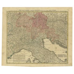
- Antique Map of the Danube River and Surroundings by Homann Heirs, c.1730By Homann HeirsLocated in Langweer, NLAntique map titled 'Danubii Fluminus (a fontibus prope Doneschingam usq Posonium urbem defignati) Pars Superior, in qua Suevia, Bavaria, Asutria, Stiria, Carinthia, Carniola, Tyrolis...Category
Antique 18th Century Maps
MaterialsPaper
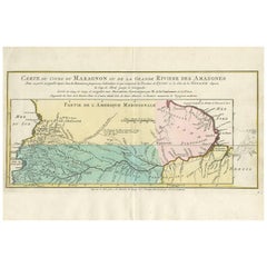
- Antique Map of the Course of the Amazon River by E. Van Harrevelt, 1773Located in Langweer, NLDetailed regional map, showing the course of the Amazon River from the Andes to the Atlantic. This map originates from 'Atlas portatif pour servir à l'intelligence de l'histoire phil...Category
Antique Late 18th Century Maps
MaterialsPaper
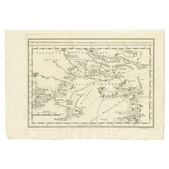
- Antique Map of the Bukhari and Surroundings by Bellin, 1749Located in Langweer, NLAntique map titled 'Carte de la Petite Bukharie et Pays Voisins'. Old map of the Bukhari (Sinkiang in north-western China) and neighboring countries. Artists and Engravers: Jacques-N...Category
Antique 18th Century Maps
MaterialsPaper
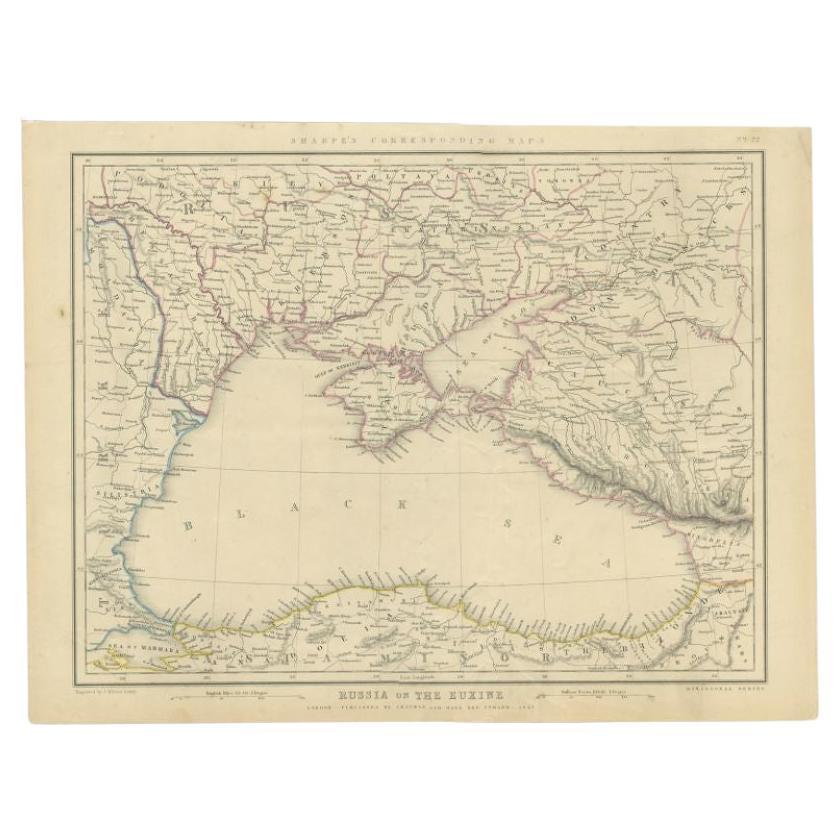
- Antique Map of the Black Sea and Surroundings by Sharpe, 1849Located in Langweer, NLAntique map titled 'Russia on the Euxine'. Old map of the Black Sea and the surrounding (Russia). This map originates from 'Sharpe's Corresponding Atlas (..)' by J. Sharpe. Artists and Engravers: Published by Chapman and Hall...Category
Antique 19th Century Maps
MaterialsPaper
- Antique Map of the Caspian Sea and Surroundings by Bellin, 1764Located in Langweer, NLAntique map titled 'Carte de la Mer Caspienne et ses Environs'. Old map depicting the region of the Caspian Sea. This map originates from 'Le Petit Atlas M...Category
Antique 18th Century Maps
MaterialsPaper
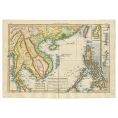
- Antique Map of the Philippines, Taiwan and Surroundings by Bonne '1780'Located in Langweer, NLAntique map titled 'Les Isles Philippines, celle de Formose, le Sud de la Chine, les Royaumes de Tunkin, de Cochinchine, de Cambode, de Siam des Laos, avec partie de Pegu et D'Ava'. ...Category
Antique Late 18th Century Maps
MaterialsPaper


You May Also Like
- Antique Oarsman's Map of the River Thames, English, Cartography, Published 1912Located in Hele, Devon, GBThis is an antique copy of The Oarsman's and Angler's Map of the River Thames - New Edition. An English, bound map book, published in English by Edward Stanford, London, this new edi...Category
Early 20th Century British Other Books
MaterialsPaper
- 1861 Topographical Map of the District of Columbia, by Boschke, Antique MapLocated in Colorado Springs, COPresented is an original map of Albert Boschke's extremely sought-after "Topographical Map of the District of Columbia Surveyed in the Years 1856 ...Category
Antique 1860s American Historical Memorabilia
MaterialsPaper
- Road Map, John Ogilby, No 54, London, Yarmouth, BritanniaBy John OgilbyLocated in BUNGAY, SUFFOLKThe Road from London to Yarmouth com. Norfolk. By John Ogilby, His Majesties Cosmographer. Containing 122 miles, 5 furlongs. No 54. From Standard in Co...Category
Antique 1670s English Baroque Maps
MaterialsPaper
- Road Map Britannia No 32 the Road from London to Barnstable John Ogilby FramedBy John OgilbyLocated in BUNGAY, SUFFOLKA road map from Britannia, by John Ogilby Esq., Cosmographer and Geographick Printer to Charles II. Containing 293 miles. No 32. From Standard in Cornhill London to Andover thence to Amesbury, to Shruton, to Warminster, to Maiden-Bradley, to Bruton, to Weston, to Ascot and to Bridgewater Hand coloured, some foxing and creasing, commensurate with age. Floated in a cream mount with a gilded linear border within a burr walnut, ebonised and gilded frame. Provenance : purchased as pair from a collector with no 15 London to St Davids. Framed as a pair. Measures: Black Linear Border around Map Length 44cm., 17 1/8" Height 36cm., 14". Full Sheet Length 51cm., 20" Height 39cm., 15 1/4" Frame Length 62cm., 24 1/2 " Height 52cm., 20 1/2" Literature: In a remarkable life John Ogilby pursued, several careers, each ending in misfortune, and yet he always emerged undeterred, to carry on. His modern reputation is based on his final career, started in his sixty-sixth year, as a publisher of maps and geographical accounts. Ogilby was born outside Dundee, in 1600, the son of a Scottish gentleman. While he was still a child, the family moved to London. When the elder Ogilby was imprisoned for debt, the young John invested his savings in a lottery, won a minor prize, and settled his father's debts. Unfortunately, not enough money was left to secure John a good apprenticeship; instead, he was apprenticed to a dance master. Ogilby was soon dancing in masques at court but, one day, while executing a particularly ambitious leap, he landed badly. The accident left him with a permanent limp, and ended his dancing career. However, he had come to the attention of Thomas Wentworth, later Earl of Strafford, Charles I's most senior minister. Ever one to exploit his contacts, Ogilby became a dance instructor in Strafford's household. When Strafford was sent to Ireland, Ogilby accompanied him as Deputy-Master of the Kings Revels, and then Master of Revels. In Dublin, he built the New Theatre, in St. Werburgh Street, which prospered at first, but the Irish Rebellion, in 1641, cost Ogilby his fortune, which he estimated at £2,000, and almost his life. After brief service as a soldier, he returned to England, survived shipwreck on the way, and arrived back penniless. On his return, Ogilby turned his attention to the Latin classics, as a translator and publisher. His first faltering attempt, in 1649, was a translation of the works of Virgil, but after his marriage to a wealthy widow the same year, his publishing activities received a considerable boost. One means by which Ogilby financed these volumes was by subscription, securing advance payments from his patrons, in return for including their name and coats-of-arms on the plates of illustrations. Another approach was to secure a patron, preferably in the court circle. Ogilby's first patron was Strafford, who found out too late that all leading ministers are dispensable when Charles I assented to his execution in 1641. As he re-established himself, Ogilby sought a new patron, the King himself. In 1661, Ogilby was approached to write poetry for Charles II's coronation procession; he later published 'The Relation of His Majesties Entertainment Passing Through the City of London', and a much enlarged edition the following year, which included a Fine set of plates depicting the procession. Royal favour was bestowed in 1674 when John Ogilby received the title of 'His Majesty's Cosmographer and Geographick Printer' with a salary of £13.6s.8d per annum. In 1665, Ogilby left London to avoid the Plague then ravaging the capital. The following year, in the Great Fire of London, Ogilby claimed that he lost his entire stock of books valued at some £3,000, as well as his shop and house, leaving him worth just £5. As he sought to restore his fortunes, Ogilby was already looking in new directions. The initial opportunity he seized on was the reconstruction of London's burnt-out centre. He secured appointment as a 'sworn viewer', whose duty was to establish the property boundaries as they existed before the Fire. Ogilby was assisted in the project by his step-grandson, William Morgan...Category
Antique Late 17th Century English Charles II Maps
MaterialsPaper
- Road Map Britannia No 25 London to the Lands End, John Ogilby Brown Gilded FrameBy John OgilbyLocated in BUNGAY, SUFFOLKThe road from London to the lands end. Commencing at the Standard in Cornhill and extending to Senan in Cornwall. By John Ogilby His Majesties Cosmographer. A road map from Britannia, 1675/6. No 25. Continuing 308 miles, 3 furlongs. London Southwark to Brentford, to Hampton Court, to Hounslow, to Windsor, to Cobham, to Farnham, to Basingstoke to Winchester The handcoloured sheet free floated. In a brown painted and gilded, ogee moulded frame. Some foxing and creasing, uneven edge of sheet, all commensurate with age Provenance : purchased as pair from a collector with no 15 London to St David's. Framed as a pair. Sheet width 48cm., 19 ”., height 38cm., 15 “ Frame width 66.5cm., 26”., height 56cm., 22 ” In a remarkable life John Ogilby pursued, several careers, each ending in misfortune, and yet he always emerged undeterred, to carry on. His modern reputation is based on his final career, started i Black Linear Border around Map Length 44cm., 17 1/8" Height 32cm., 12 1/2" Full Sheet Length 58cm., 22 3/4" Height 38cm., 15" Frame Length 66cm., 26"., Height 56cm., 22" In a remarkable life John Ogilby pursued, several careers, each ending in misfortune, and yet he always emerged undeterred, to carry on. His modern reputation is based on his final career, started in his sixty-sixth year, as a publisher of maps and geographical accounts. Ogilby was born outside Dundee, in 1600, the son of a Scottish gentleman. While he was still a child, the family moved to London. When the elder Ogilby was imprisoned for debt, the young John invested his savings in a lottery, won a minor prize, and settled his father's debts. Unfortunately, not enough money was left to secure John a good apprenticeship; instead, he was apprenticed to a dance master. Ogilby was soon dancing in masques at court but, one day, while executing a particularly ambitious leap, he landed badly. The accident left him with a permanent limp, and ended his dancing career. However, he had come to the attention of Thomas Wentworth, later Earl of Strafford, Charles I's most senior minister. Ever one to exploit his contacts, Ogilby became a dance instructor in Strafford's household. When Strafford was sent to Ireland, Ogilby accompanied him as Deputy-Master of the Kings Revels, and then Master of Revels. In Dublin, he built the New Theatre, in St. Werburgh Street, which prospered at first, but the Irish Rebellion, in 1641, cost Ogilby his fortune, which he estimated at £2,000, and almost his life. After brief service as a soldier, he returned to England, survived shipwreck on the way, and arrived back penniless. On his return, Ogilby turned his attention to the Latin classics, as a translator and publisher. His first faltering attempt, in 1649, was a translation of the works of Virgil, but after his marriage to a wealthy widow the same year, his publishing activities received a considerable boost. One means by which Ogilby financed these volumes was by subscription, securing advance payments from his patrons, in return for including their name and coats-of-arms on the plates of illustrations. Another approach was to secure a patron, preferably in the court circle. Ogilby's first patron was Strafford, who found out too late that all leading ministers are dispensable when Charles I assented to his execution in 1641. As he re-established himself, Ogilby sought a new patron, the King himself. In 1661, Ogilby was approached to write poetry for Charles II's coronation procession; he later published 'The Relation of His Majesties Entertainment Passing Through the City of London', and a much enlarged edition the following year, which included a fine set of plates depicting the procession. Royal favour was bestowed in 1674 when John Ogilby received the title of 'His Majesty's Cosmographer and Geographick Printer' with a salary of £13.6s.8d per annum. In 1665, Ogilby left London to avoid the Plague then ravaging the capital. The following year, in the Great Fire of London, Ogilby claimed that he lost his entire stock of books valued at some £3,000, as well as his shop and house, leaving him worth just £5. As he sought to restore his fortunes, Ogilby was already looking in new directions. The initial opportunity he seized on was the reconstruction of London's burnt-out centre. He secured appointment as a "sworn viewer", whose duty was to establish the property boundaries as they existed before the Fire. Ogilby was assisted in the project by his step-grandson, William Morgan...Category
Antique Late 17th Century British Charles II Maps
MaterialsPaper
- Road Map, John Ogilby, London, Barwick, York, Chester, Darlington, Durham FramedBy John OgilbyLocated in BUNGAY, SUFFOLKThe continuation of the road from London to Barwick beginning at York and extending to Chester in ye Street. Plate ye 4th continuing 76 ½ miles. No 8. York to Burrowbridge, to Top...Category
Antique 1670s English Baroque Maps
MaterialsPaper


Recently Viewed
View AllMore Ways To Browse
Worlds Fair Plate
17th Century Scotland
17th Century Scottish
Scottish Decor
Map Amazon
John Ogilby
Antique 16th Century Plates
Antique Caribbean Furniture
17th Century Plate Set
Antique Rose Compass
Antique Map Paint
Israeli Antique
North America Antique Map
Antique Maps Of North America
Tree Bag
Survey Map
Ohio Antique
16th Century Scotland