Items Similar to Antique Map of The Senegal River by Bellin, 1746


Want more images or videos?
Request additional images or videos from the seller
1 of 5
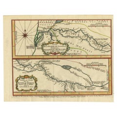
Antique Map of The Senegal River by Bellin, 1746
About the Item
Antique map titled 'Carte de l'Entrée de la Rivière de Sanaga ou Senegal'. Map of the mouth of the Senegal River. This map originates from Prevost's 'Histoire Generale des Voyages'.
Artists and Engravers: Antoine Francois Prevost d'Exiles (1697-1763), usually known simply as the Abbe Prevost, was a French author and novelist. Engraved by J.N. Bellin.
Condition: Good, general age-related toning. Minor wear, blank verso. Please study image carefully.
Date: 1746
Overall size: 17 x 23.5 cm.
Image size: 0.001 x 15 x 22 cm.
- Dimensions:Height: 9.26 in (23.5 cm)Width: 6.7 in (17 cm)Depth: 0 in (0.01 mm)
- Materials and Techniques:
- Period:
- Date of Manufacture:1746
- Condition:
- Seller Location:Langweer, NL
- Reference Number:
About the Seller
5.0
Platinum Seller
These expertly vetted sellers are 1stDibs' most experienced sellers and are rated highest by our customers.
Established in 2009
1stDibs seller since 2017
1,928 sales on 1stDibs
Typical response time: <1 hour
- ShippingRetrieving quote...Ships From: Langweer, Netherlands
- Return PolicyA return for this item may be initiated within 14 days of delivery.
More From This SellerView All
- Antique Map of Gorée Island ‘Senegal’ by J.N. Bellin, 1764Located in Langweer, NLNautical antique chart of Gorée Senegal including a letter key to the island's fortifications. Gorée is known as the location of the House of Slaves built by an Afro-French Métis fam...Category
Antique Mid-18th Century Maps
MaterialsPaper
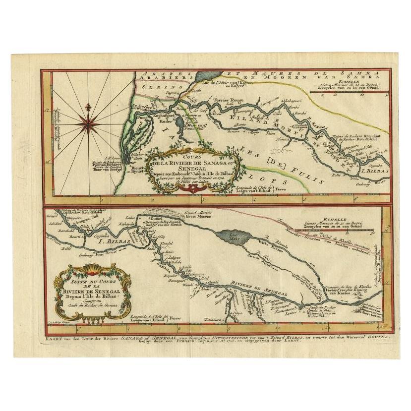
- Antique Map of the Sanaga River, Senegal, 1747Located in Langweer, NLAntique map titled 'Cours De La Riviere De Sanaga Ou Senegal (..) - Kaart van den Loop der Riviere Sanaga (..)'. Attractive double map of the Sanaga River, Senegal, Africa. This map ...Category
Antique 18th Century Maps
MaterialsPaper
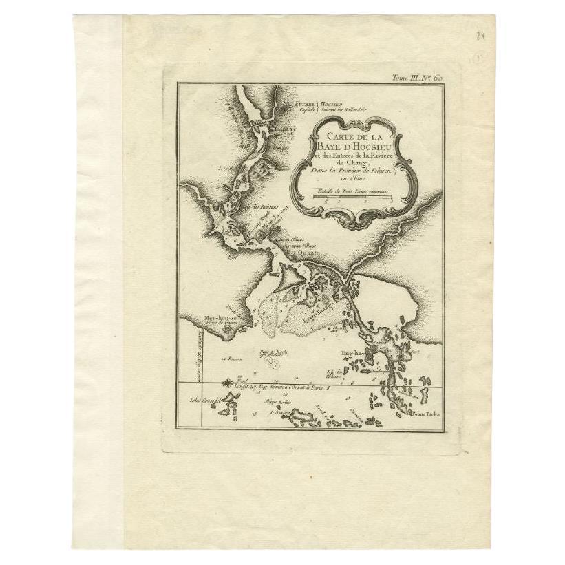
- Antique Map of the Mouth of the Chiang River by Bellin, 1764By Jacques-Nicolas BellinLocated in Langweer, NLAntique map titled ‘Carte de la Baye d'Hocsieu et des Entrees de la Riviere de Chang, Dans la Province de Fokyen en Chine’. This impressive map or sea chart d...Category
Antique 18th Century Maps
MaterialsPaper
- Antique Map of the Tonkin River ‘Vietnam’ by J.N. Bellin, 1764Located in Langweer, NLOne of the maps produced by Bellin for Prevost d'Exiles' influential travel book, ‘L'Histoire Generale des Voyages’. This map depicts part of Southeast Asia, most likely northern Vie...Category
Antique Mid-18th Century Maps
MaterialsPaper
- Antique Map of the Mouth of the Yangtze River 'China' by J.N. Bellin, 1764Located in Langweer, NLThis detailed regional map of China is a historical cartographic work from the mid-18th century and is attributed to Antoine-François Prévost, a prominent French cartographer and geo...Category
Antique Mid-18th Century Maps
MaterialsPaper
- Antique Map of the Arabian Peninsula by Bellin 'c.1740'Located in Langweer, NLAntique map titled 'Carte de la Coste d'Arabie, Mer Rouge et Golfe de Perse'. Original antique map of the Arabian Peninsula, labes both Mecca and Med...Category
Antique Mid-18th Century Maps
MaterialsPaper


You May Also Like
- Antique Oarsman's Map of the River Thames, English, Cartography, Published 1912Located in Hele, Devon, GBThis is an antique copy of The Oarsman's and Angler's Map of the River Thames - New Edition. An English, bound map book, published in English by Edward Stanford, London, this new edi...Category
Early 20th Century British Other Books
MaterialsPaper
- Captain Cook's Exploration of Tahiti 18th C. Hand-Colored Map by BellinBy Jacques-Nicolas BellinLocated in Alamo, CAThis beautiful 18th century hand-colored copper plate engraved map is entitled "Carte de l'Isle de Taiti, par le Lieutenant J. Cook" was created by Jacques Nicolas Bellin and publish...Category
Antique Mid-18th Century French Maps
MaterialsPaper
- 1861 Topographical Map of the District of Columbia, by Boschke, Antique MapLocated in Colorado Springs, COPresented is an original map of Albert Boschke's extremely sought-after "Topographical Map of the District of Columbia Surveyed in the Years 1856 ...Category
Antique 1860s American Historical Memorabilia
MaterialsPaper
- West Coast of Africa, Guinea & Sierra Leone: An 18th Century Map by BellinBy Jacques-Nicolas BellinLocated in Alamo, CAJacques Bellin's copper-plate map entitled "Partie de la Coste de Guinee Dupuis la Riviere de Sierra Leona Jusquau Cap das Palmas", depicting the coast of Guinea and Sierra Leone in ...Category
Antique Mid-18th Century French Maps
MaterialsPaper
- Original Antique Map of The World by Thomas Clerk, 1817Located in St Annes, LancashireGreat map of The Eastern and Western Hemispheres On 2 sheets Copper-plate engraving Drawn and engraved by Thomas Clerk, Edinburgh. Published by Mackenzie And Dent, 1817 ...Category
Antique 1810s English Maps
MaterialsPaper
- St. Christophe 'St. Kitts' Island: An 18th Century Hand-colored Map by BellinBy Jacques-Nicolas BellinLocated in Alamo, CAJacques Bellin's copper-plate map of the Caribbean island of Saint Kitts entitled "Carte De De l'Isle St. Christophe Pour servir á l'Histoire Genle. des V...Category
Antique Mid-18th Century French Maps
MaterialsPaper


