Items Similar to Antique Map of the Sanaga River, Senegal, 1747

Want more images or videos?
Request additional images or videos from the seller
1 of 5
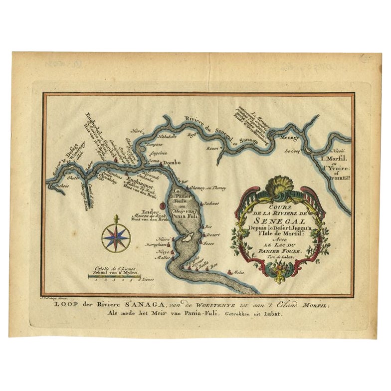
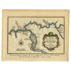
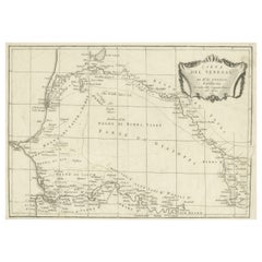
Antique Map of the Sanaga River, Senegal, 1747
About the Item
Antique map titled 'Cours De La Riviere De Sanaga Ou Senegal (..) - Kaart van den Loop der Riviere Sanaga (..)'. Attractive double map of the Sanaga River, Senegal, Africa. This map originates from 'Historische beschryving der Reizen (..)' published by P. de Hondt, 1747.
Artists and Engravers: Jacob van der Schley was a dutch engraver and artist, who studied under the French engraver Bernard Picart (1673-1733).
Condition: Very good, given age. Original folds as issued. General age-related toning and/or occasional minor defects from handling. Please study image carefully.
Date: 1747
Overall size: 31.5 x 25 cm.
Image size: 28.5 x 22.3 cm.
We sell original antique maps to collectors, historians, educators and interior decorators all over the world. Our collection includes a wide range of authentic antique maps from the 16th to the 20th centuries. Buying and collecting antique maps is a tradition that goes back hundreds of years. Antique maps have proved a richly rewarding investment over the past decade, thanks to a growing appreciation of their unique historical appeal. Today the decorative qualities of antique maps are widely recognized by interior designers who appreciate their beauty and design flexibility. Depending on the individual map, presentation, and context, a rare or antique map can be modern, traditional, abstract, figurative, serious or whimsical. We offer a wide range of authentic antique maps for any budget.
- Dimensions:Height: 9.85 in (25 cm)Width: 12.41 in (31.5 cm)Depth: 0 in (0.01 mm)
- Materials and Techniques:
- Period:
- Date of Manufacture:1747
- Condition:Condition: Very good, given age. Original folds as issued. General age-related toning and/or occasional minor defects from handling. Please study image carefully.
- Seller Location:Langweer, NL
- Reference Number:
About the Seller
5.0
Platinum Seller
These expertly vetted sellers are 1stDibs' most experienced sellers and are rated highest by our customers.
Established in 2009
1stDibs seller since 2017
1,947 sales on 1stDibs
Typical response time: <1 hour
- ShippingRetrieving quote...Ships From: Langweer, Netherlands
- Return PolicyA return for this item may be initiated within 14 days of delivery.
More From This SellerView All
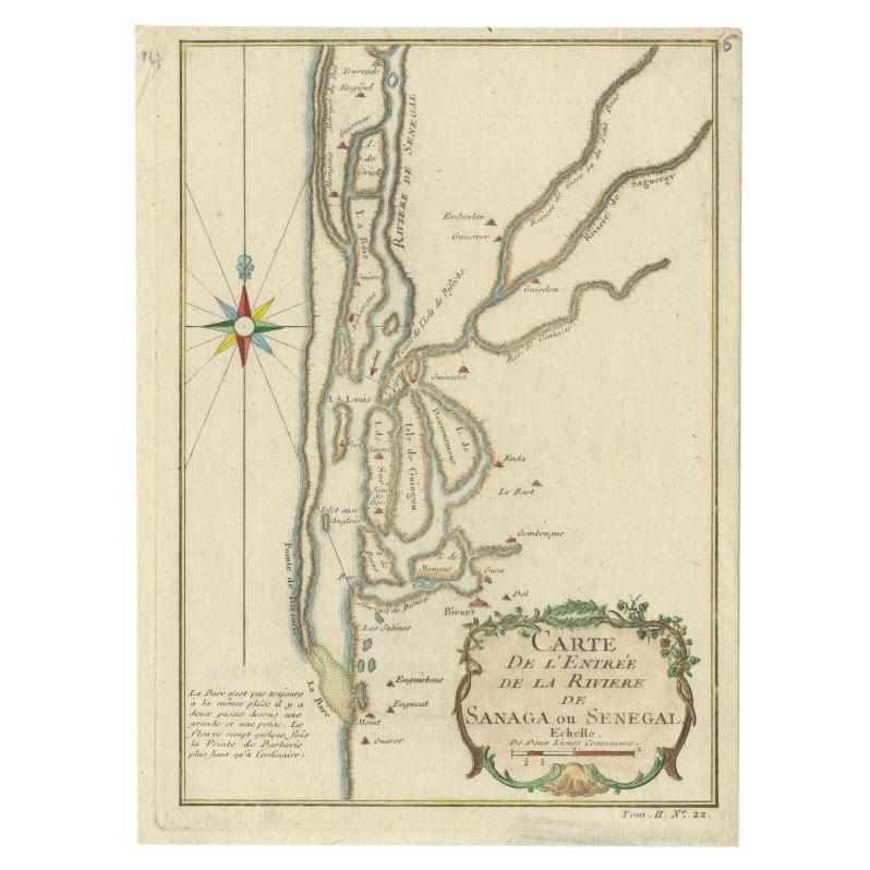
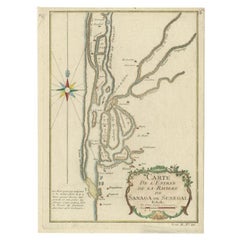
- Antique Map of the Course of the Sanaga River by Van Schley, 1747Located in Langweer, NLAntique map titled 'Cours de la Riviere de Senegal (..) - Loop der Riviere Sanaga (..)'. Original antique map of the course of the Sanaga River that forms the border between Senegal ...Category
Antique 18th Century Maps
MaterialsPaper
- Antique Map of The Senegal River by Bellin, 1746Located in Langweer, NLAntique map titled 'Carte de l'Entrée de la Rivière de Sanaga ou Senegal'. Map of the mouth of the Senegal River. This map originates from Prevost's 'Histoire Generale des Voyages'. ...Category
Antique 18th Century Maps
MaterialsPaper
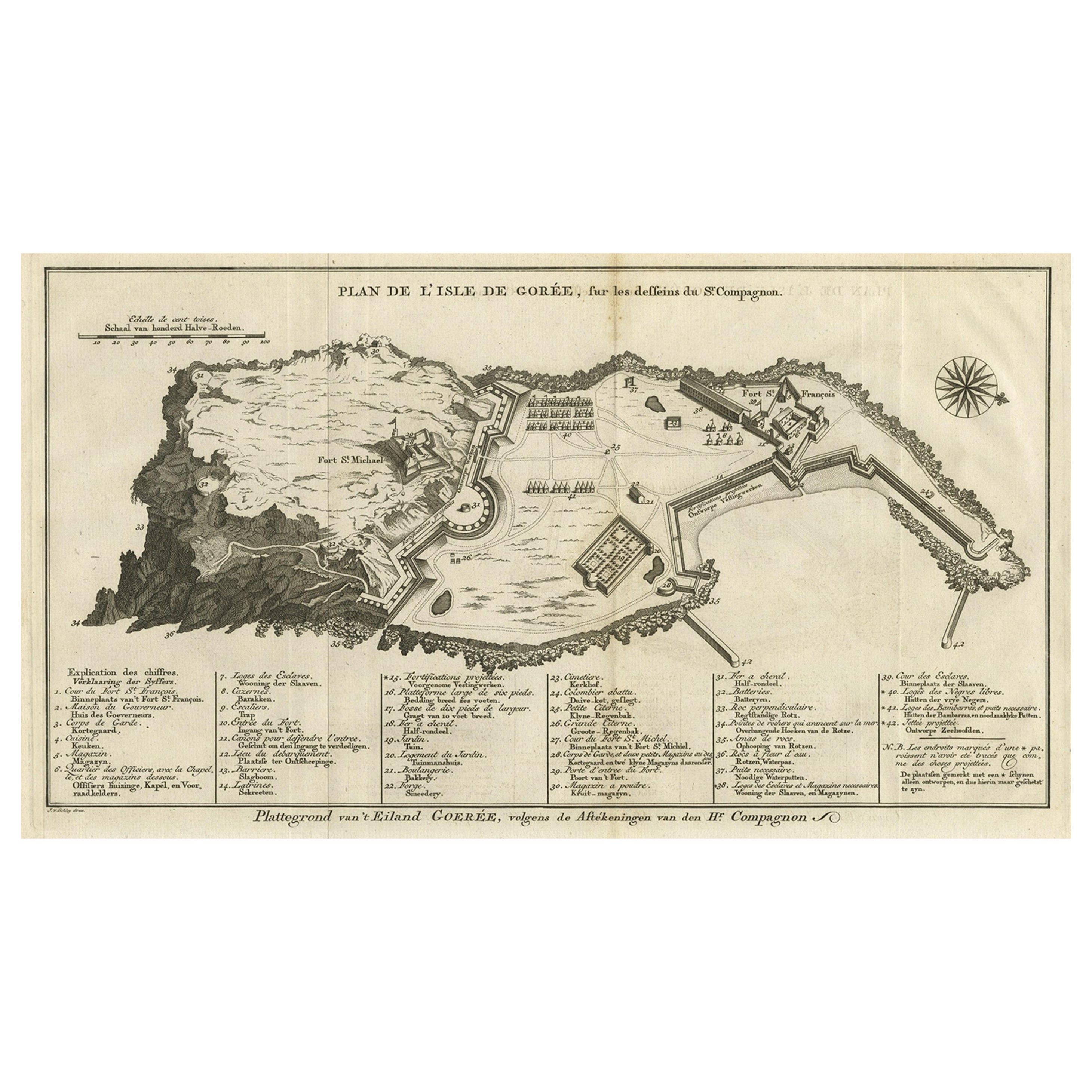
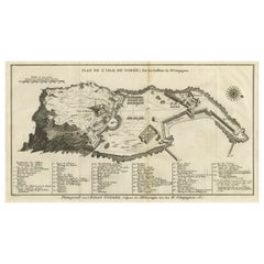
- Detailed Map of the Island of Gorée off of the Coast of Dakar, Senegal, 1747Located in Langweer, NLAntique plan titled 'Plan de l'Isle de Goree The island of Gorée lies off the coast of Senegal, opposite Dakar. From the 15th to the 19th century, it was the largest slave-tradin...Category
Antique 1740s Maps
MaterialsPaper
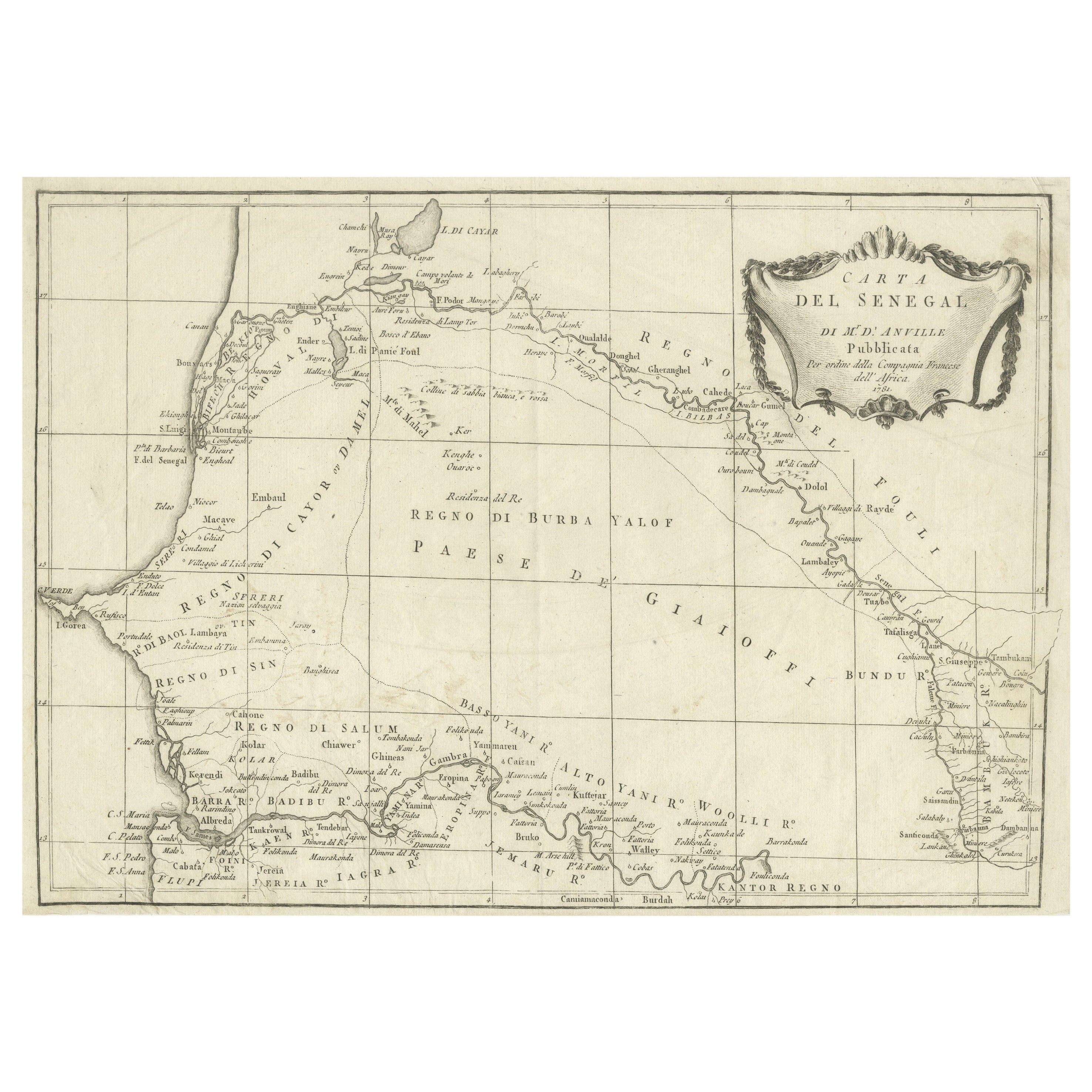
- Antique Map of Senegal, West AfricaLocated in Langweer, NLOriginal antique map titled 'Carta del Senegal'. Antique map of Senegal, West Africa. This map originates from 'Compendio della storia generale dei viaggi (..)'. Published by De la Harpe...Category
Antique Mid-18th Century Maps
MaterialsPaper
- Antique Map of Sweden by Bowen, 1747Located in Langweer, NLAntique map titled 'A New & Accurate Map of Sweden'. This map covers Sweden and Finland (shown as part of Sweden) as well as parts of modern day Estonia,...Category
Antique 18th Century Maps
MaterialsPaper
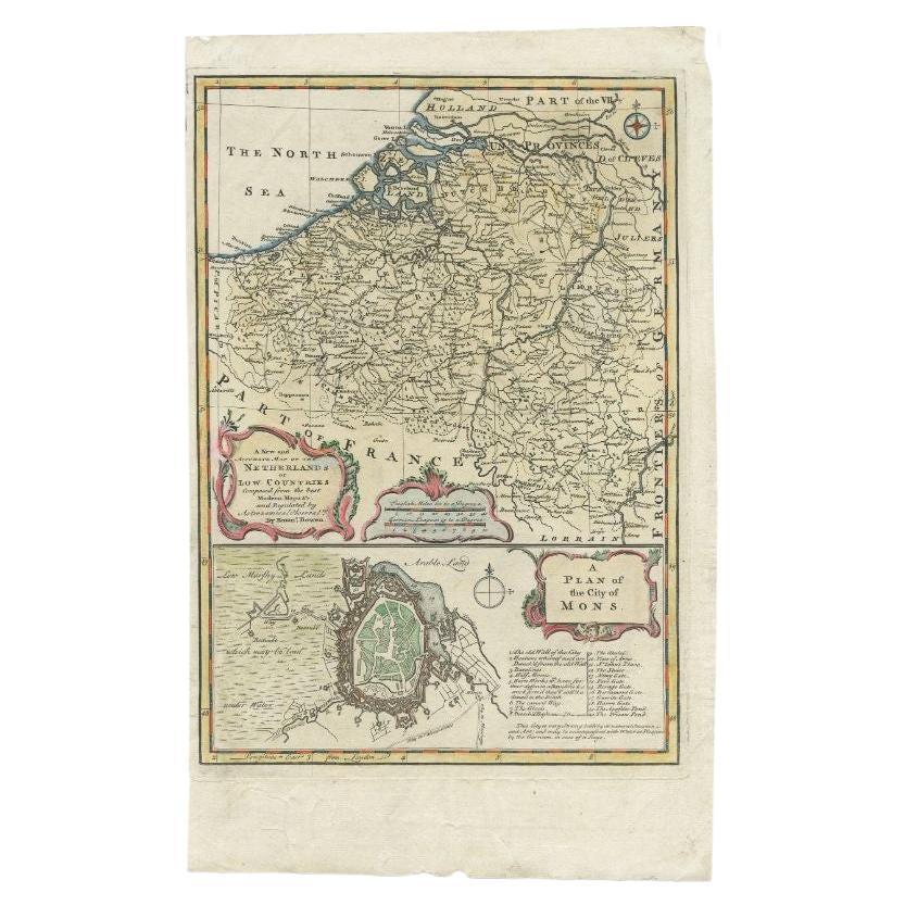
- Antique Map of the Netherlands and Belgium by Bowen, 1747By Emanuel BowenLocated in Langweer, NLAntique map Belgium titled 'A New and Accurate Map of the Netherlands or Low Countries'. Detailed map of South of the Netherlands and Belgium. With large inset of the city of Mons, B...Category
Antique 18th Century Maps
MaterialsPaper

You May Also Like
- Antique Oarsman's Map of the River Thames, English, Cartography, Published 1912Located in Hele, Devon, GBThis is an antique copy of The Oarsman's and Angler's Map of the River Thames - New Edition. An English, bound map book, published in English by Edward Stanford, London, this new edi...Category
Early 20th Century British Other Books
MaterialsPaper
- 1861 Topographical Map of the District of Columbia, by Boschke, Antique MapLocated in Colorado Springs, COPresented is an original map of Albert Boschke's extremely sought-after "Topographical Map of the District of Columbia Surveyed in the Years 1856 ...Category
Antique 1860s American Historical Memorabilia
MaterialsPaper
- Original Antique Map of the American State of Pennsylvania, 1889Located in St Annes, LancashireGreat map of Pennsylvania Drawn and Engraved by W. & A.K. Johnston Published By A & C Black, Edinburgh. Original colour Unframed. Repair to a minor tear on bottom edge.Category
Antique 1880s Scottish Victorian Maps
MaterialsPaper
- Original Antique Map of the American State of Oregon, 1889Located in St Annes, LancashireGreat map of Oregon Drawn and Engraved by W. & A.K. Johnston Published By A & C Black, Edinburgh. Original colour Unframed.Category
Antique 1880s Scottish Victorian Maps
MaterialsPaper
- Original Antique Map of the American State of Nevada, 1889Located in St Annes, LancashireGreat map of Nevada Drawn and Engraved by W. & A.K. Johnston Published By A & C Black, Edinburgh. Original colour Unframed.Category
Antique 1880s Scottish Victorian Maps
MaterialsPaper
- Map of the Republic of GenoaLocated in New York, NYFramed antique hand-coloured map of the Republic of Genoa including the duchies of Mantua, Modena, and Parma. Europe, late 18th century. Dimension: 25...Category
Antique Late 18th Century European Maps


Recently Viewed
View AllMore Ways To Browse
Jacobs Antique
African P
Antique Riviere
Antique Map Of Australia
Antique Australian Map
Antique Australian Maps
Antique Furniture In The Philippines
Antique Map Japan
Large Framed Antique Maps
Antique Filipino
Antique Baltic
Political Map
Map Of Ireland
Ireland Map
Irish Map
Captain Cook
Norwegian Antiques
Large Antique City Maps