Items Similar to Antique Map of the Rhine and Moselle River Region in Germany and France, c.1680

Want more images or videos?
Request additional images or videos from the seller
1 of 5
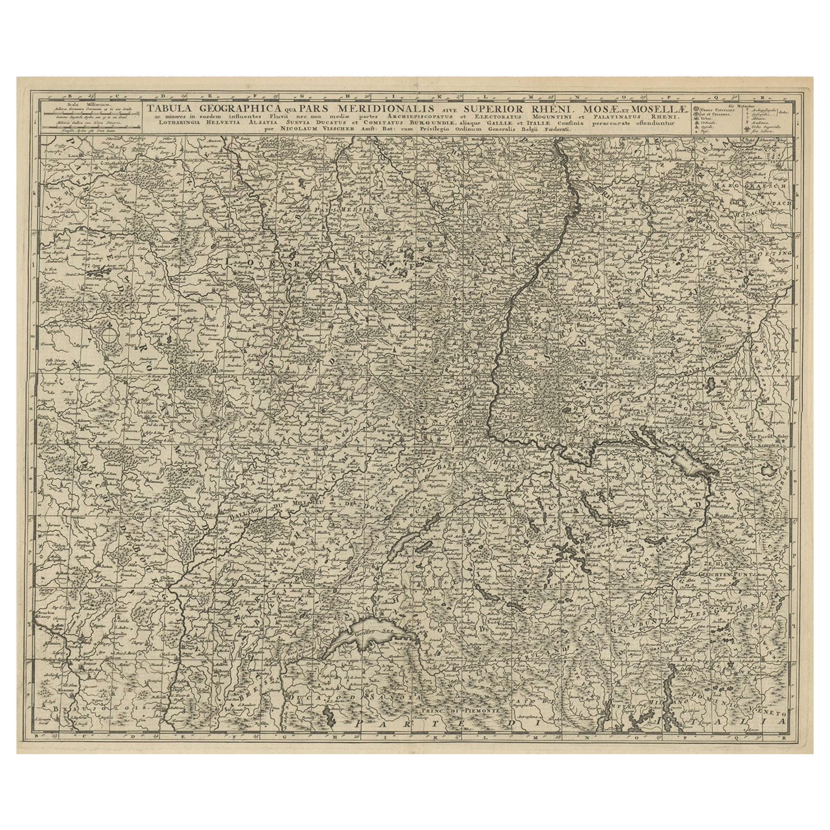
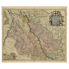
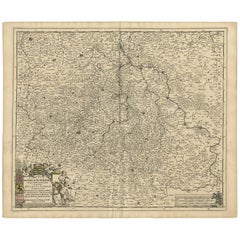
Antique Map of the Rhine and Moselle River Region in Germany and France, c.1680
About the Item
Antique map titled 'Tabula Geographica qui Pars Meridionalis sive Superior Rheni, Mosae et Mosellae (..).'
Detailed map of the Rhine and Moselle River regions and contigous parts of France and Germany, from one of the leading Dutch map makers of the late 17th and early 18th Centuries. Fully engraved to show mountains, rivers, lakes, streams, forests, lowlands, cities, fortifications, and tiny villages. Source unknown, to be determined.
Artists and Engravers: For nearly a century the members of the Visscher family were important art dealers and map publishers in Amsterdam. The founder of the business, C. J. Visscher, had premises near to those of Pieter van den Keere and Jodocus Hondius whose pupil he may have been. From about 1620 he designed a number of individual maps, including one of the British Isles, but his first atlas consisted of maps printed from plates bought from van den Keere and issued as they stood with some additions of his own, including historical scenes of battles and sieges for which he had a high reputation. Some maps bear the latinized form of the family name: Piscator. After Visscher's death his son and grandson, both of the same name, issued a considerable number of atlases, constantly revised and brought up to date but most of them lacking an index and with varying contents. The widow of Nicholaes Visscher II carried on the business until it finally passed into the hands of Pieter Schenk.
Condition: Good, given age. Edges and margins partly browned. Bottom margin damp stained. Several creases left side. Original middle fold as issued. General age-related toning and/or occasional minor defects from handling. Please study scan carefully.
Date: c.1680
Overall size: 60.8 x 51.8 cm.
Image size: 56 x 47.3 cm.
We sell original antique maps to collectors, historians, educators and interior decorators all over the world. Our collection includes a wide range of authentic antique maps from the 16th to the 20th centuries. Buying and collecting antique maps is a tradition that goes back hundreds of years. Antique maps have proved a richly rewarding investment over the past decade, thanks to a growing appreciation of their unique historical appeal. Today the decorative qualities of antique maps are widely recognized by interior designers who appreciate their beauty and design flexibility. Depending on the individual map, presentation, and context, a rare or antique map can be modern, traditional, abstract, figurative, serious or whimsical. We offer a wide range of authentic antique maps for any budget.
- Dimensions:Height: 20.4 in (51.8 cm)Width: 23.94 in (60.8 cm)Depth: 0 in (0.01 mm)
- Materials and Techniques:
- Period:
- Date of Manufacture:circa 1680
- Condition:Condition: Good, given age. Edges and margins partly browned. Bottom margin damp stained. Several creases left side. Original middle fold as issued. General age-related toning and/or occasional minor defects from handling. Please study scan carefully.
- Seller Location:Langweer, NL
- Reference Number:
About the Seller
5.0
Platinum Seller
These expertly vetted sellers are 1stDibs' most experienced sellers and are rated highest by our customers.
Established in 2009
1stDibs seller since 2017
1,916 sales on 1stDibs
Typical response time: <1 hour
- ShippingRetrieving quote...Ships From: Langweer, Netherlands
- Return PolicyA return for this item may be initiated within 14 days of delivery.
More From This SellerView All
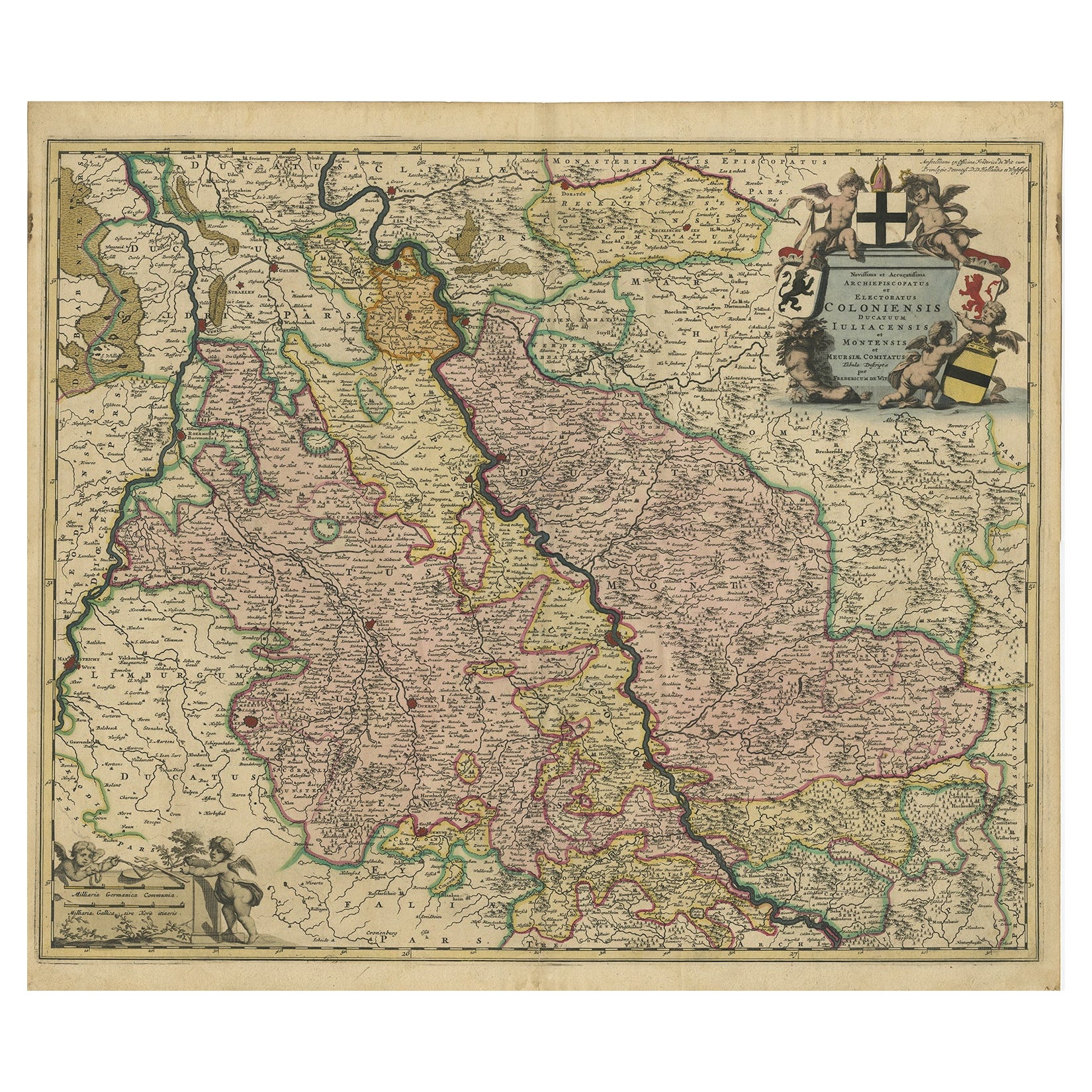
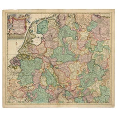
- Rhine Splendor: Antique Map of the Lower Rhine Region, circa 1680Located in Langweer, NLThe antique map titled 'Novissima et Accuratissima Archiepiscopatus et Electoratus Coloniensis Ducatuum Iuliancensis et Montensis et Meursiae Comitatus' is a handsome and detailed ma...Category
Antique 1680s Maps
MaterialsPaper
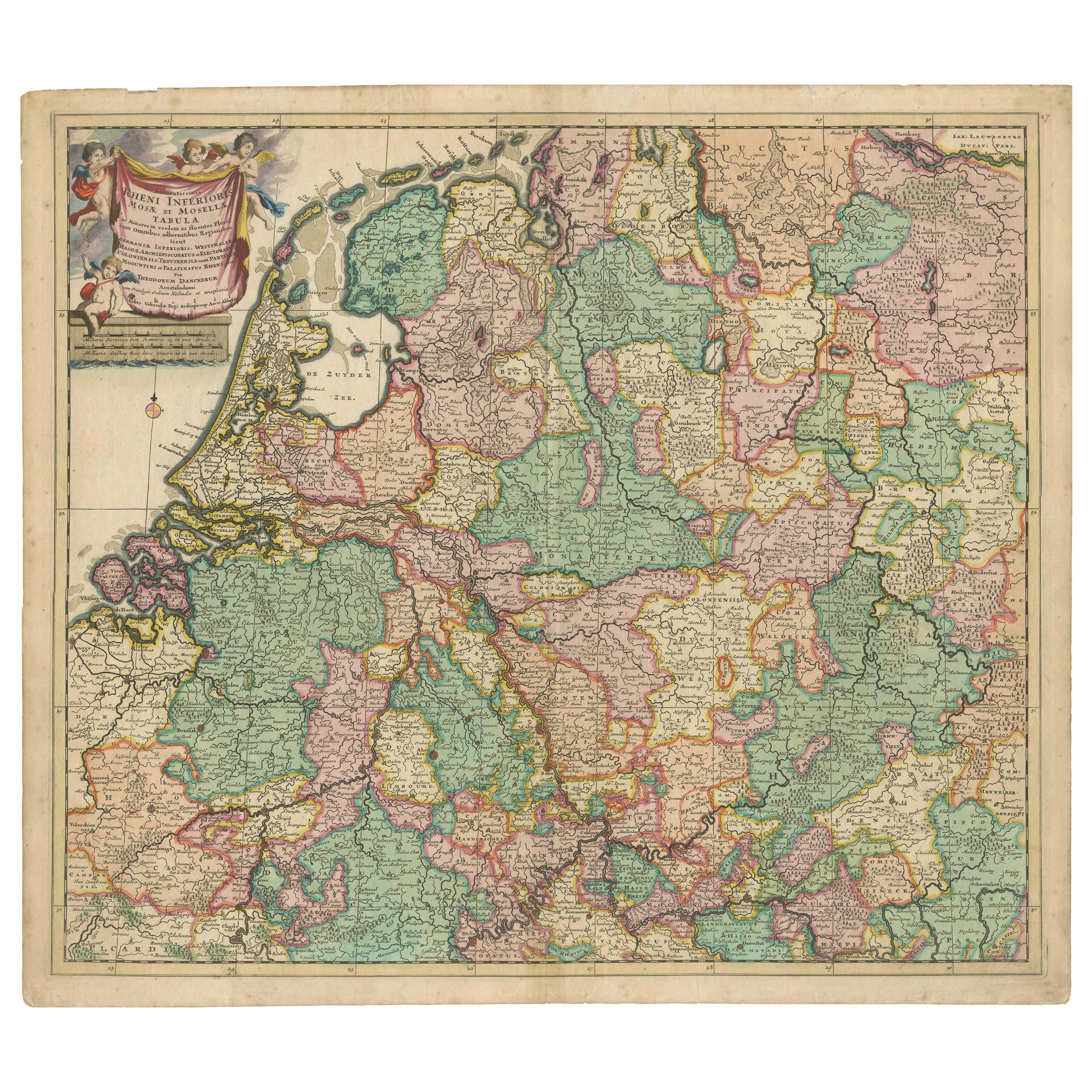
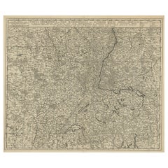
- Rare Theodore Danckerts Map of the Lower Rhine and Moselle River RegionsLocated in Langweer, NLOriginal antique map titled 'Accuratissima Rheni Inferioris Mosae et Mosellae Tabula'. Rare Theodore Danckerts map of the Lower Rhine and Moselle River Regions. The map covers the lo...Category
Antique Early 18th Century Maps
MaterialsPaper
- Original Antique Detailed Map of the Rhine and Moselle River Regions, ca.1680Located in Langweer, NLAntique map titled 'Tabula Geographica qui Pars Meridionalis sive Superior Rheni, Mosae et Mosellae (..).' Detailed map of the Rhine and Moselle River regions and contigous parts...Category
Antique 1680s Maps
MaterialsPaper
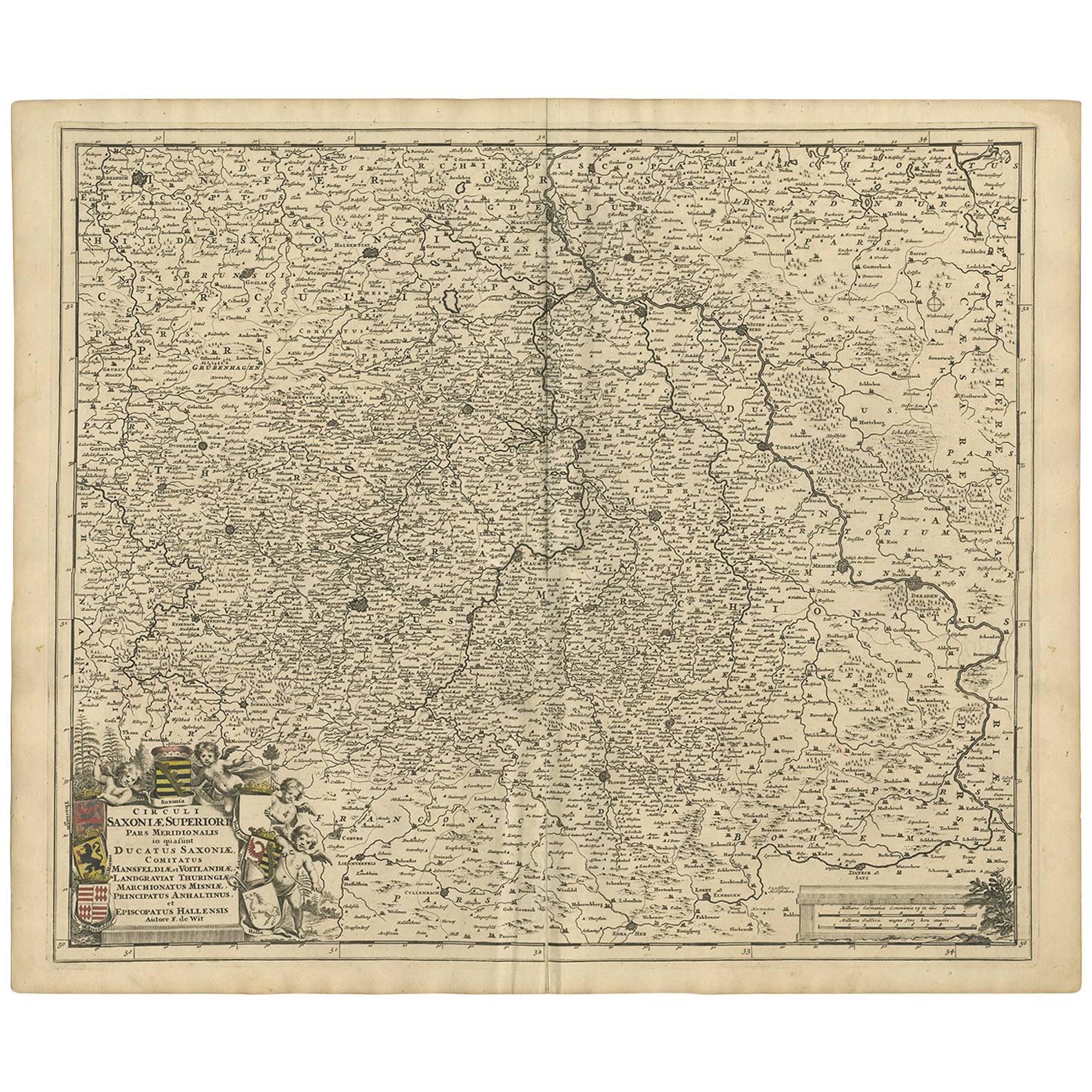
- Antique Map of the Saxony Region 'Germany' by F. de Wit, circa 1680Located in Langweer, NLA detailed map of a region in eastern Germany. Cartouches depict coat of arms surrounded by cherubs. The map is fully engraved with towns, political boundaries, rivers and forests. P...Category
Antique Late 17th Century Maps
MaterialsPaper
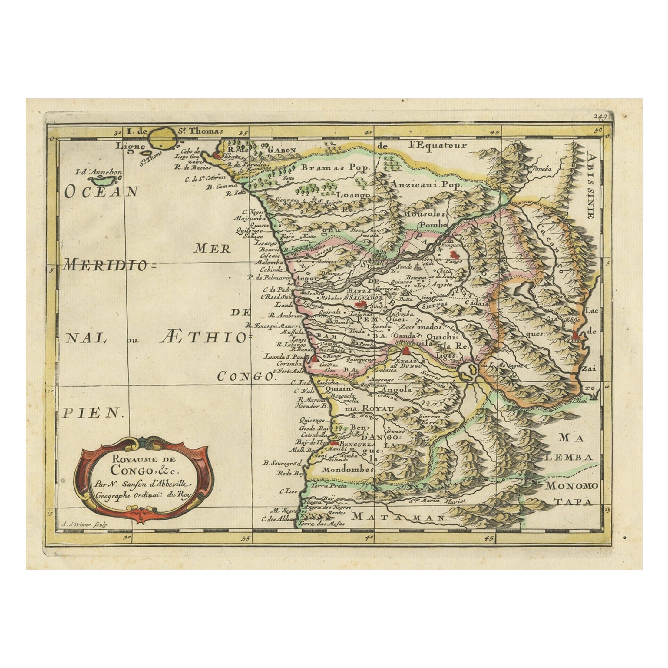
- Antique Map of Gabon, Angola and the Congo Region in Africa c.1680Located in Langweer, NLAntique map titled 'Royaume de Congo'. Map of Gabon, the Congo and Angola from Cape Lopez and Sao Tomé to approximately the border with present-day Namibia. The map is fully engrav...Category
Antique 17th Century Maps
MaterialsPaper
- Antique Map of the Namur Region 'France' by F. de Wit, circa 1680Located in Langweer, NLAntique map titled 'Comitatus Namurci Tabula in Lucem Edita'. Large map of the Namur region, France. Published by F. de Wit, circa 1680.Category
Antique Late 17th Century Maps
MaterialsPaper

You May Also Like
- Germany West of the Rhine: A Hand-colored 18th Century Map by de WitBy Frederick de WitLocated in Alamo, CAThis original 18th century hand-colored map of the county of Moers, Germany entitled "Illustrissimo Celsissmo Principi GUILIELMO HENRICO D.G. Arausionum Principi Domino suo Clementis...Category
Antique Early 18th Century Dutch Maps
MaterialsPaper
- The Normandy Region of France: A 17th C. Hand-colored Map by Sanson and JaillotBy Nicolas SansonLocated in Alamo, CAThis large hand-colored map entitled "Le Duché et Gouvernement de Normandie divisée en Haute et Basse Normandie en divers Pays; et par evêchez, avec le Gouvernement General du Havre ...Category
Antique 1690s French Maps
MaterialsPaper
- 17th Century Hand-Colored Map of a Region in West Germany by JanssoniusBy Johannes JanssoniusLocated in Alamo, CAThis attractive highly detailed 17th century original hand-colored map is entitled "Archiepiscopatus Maghdeburgensis et Anhaltinus Ducatus cum terris adjacentibus". It was published ...Category
Antique Mid-17th Century Dutch Maps
MaterialsPaper
- 17th Century Hand Colored Map of the Liege Region in Belgium by VisscherBy Nicolaes Visscher IILocated in Alamo, CAAn original 17th century map entitled "Leodiensis Episcopatus in omnes Subjacentes Provincias distincté divisusVisscher, Leodiensis Episcopatus" by Nicolaes Visscher II, published in Amsterdam in 1688. The map is centered on Liege, Belgium, includes the area between Antwerp, Turnhout, Roermond, Cologne, Trier and Dinant. This attractive map is presented in a cream-colored mat measuring 30" wide x 27.5" high. There is a central fold, as issued. There is minimal spotting in the upper margin and a tiny spot in the right lower margin, which are under the mat. The map is otherwise in excellent condition. The Visscher family were one of the great cartographic families of the 17th century. Begun by Claes Jansz Visscher...Category
Antique Late 17th Century Dutch Maps
MaterialsPaper
- 17th Century Topographical Map, French Champagne Region, Epernay, Iohan PeetersLocated in New York, NYFine topographical 17th century map by Iohan Peeters of the towns of Epernay and Lametz in the Champagne Region of North Eastern France. Fabulous period engraving for a Wine Cellar,...Category
Antique 17th Century Dutch Maps
MaterialsPaper
- Original Antique Map of France, Arrowsmith, 1820Located in St Annes, LancashireGreat map of France Drawn under the direction of Arrowsmith. Copper-plate engraving. Published by Longman, Hurst, Rees, Orme and Brown, 1820 Unframed.Category
Antique 1820s English Maps
MaterialsPaper


Recently Viewed
View AllMore Ways To Browse
French 17th C Furniture
German 18th C
Circa 1620
Siege Antique
German Collector Plate
Dutch Battle
Bear Lake
Battle Maps
17th Century Battle Scene
Antique Battle Maps
Antique Map Art Collectibles
Antique Maps Art Collectibles
Visscher Amsterdam
Antique French Battle Scene
Rhine River
British Isles Antique Map
Captain Cook
Norwegian Antiques