Items Similar to Rhine Splendor: Antique Map of the Lower Rhine Region, circa 1680


Want more images or videos?
Request additional images or videos from the seller
1 of 5
Rhine Splendor: Antique Map of the Lower Rhine Region, circa 1680
About the Item
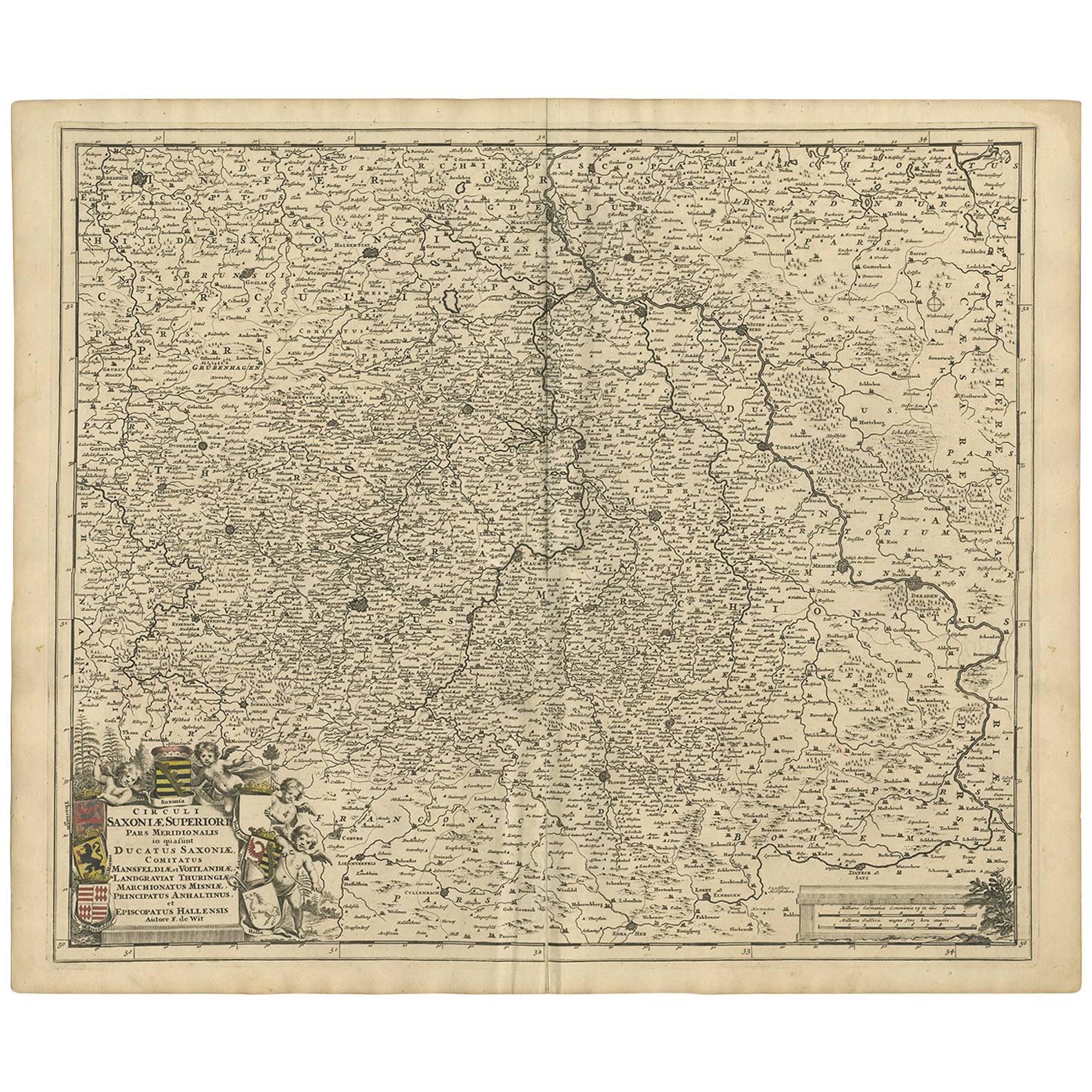
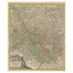
The antique map titled 'Novissima et Accuratissima Archiepiscopatus et Electoratus Coloniensis Ducatuum Iuliancensis et Montensis et Meursiae Comitatus' is a handsome and detailed map of the lower Rhine region in Germany, with a focus on the city of Cologne. Here are the key details:
1. **Geographic Coverage**:
- The map provides a comprehensive view of the lower Rhine region in Germany.
- It covers the territories of the Archbishopric and Electorate of Cologne, the Duchy of Julich (Jülich), the Duchy of Berg (Montensis), and the County of Meurs (Meursiae).
2. **Cartographic Details**:
- The map is fully engraved with precise details, including the locations of towns, political boundaries, rivers, and forests.
- It offers a valuable historical representation of the geography of the region during the period in which it was created.
3. **Cartouches**:
- The map is embellished with two cartouches:
- The title cartouche features putti (cherubic figures) and coats of arms, adding decorative elements to the map.
- Below, there is another cartouche that includes a scale and more putti, enhancing the map's aesthetic appeal.
4. **Attribution**:
- The map is attributed to 'Frederick de Wit,' who likely played a role in its production. However, the map was made after the work of an anonymous artist.
5. **Source**:
- The exact source of this map, such as the original publication or source material used, may require further historical research to determine.
Overall, this antique map serves as a valuable historical document that provides insights into the lower Rhine region of Germany during the period it represents. Its detailed cartography and decorative elements make it a notable example of cartographic artistry from the era in which it was created.Frederik/Frederick de Wit (Amsterdam 1630-1706), was a famous engraver and publisher in Amsterdam. He acquired many of the printing plates of Blaeu and Janssonius when it came to auction. His map were very popular because of the quality of the engravings and the beautiful colouring. After his death his work was re-issued by Pieter Mortier and Covens & Mortier.
- Dimensions:Height: 21.03 in (53.4 cm)Width: 24.22 in (61.5 cm)Depth: 0 in (0.02 mm)
- Materials and Techniques:
- Period:1680-1689
- Date of Manufacture:circa 1680
- Condition:Good, given age. Minor paper separation bottom middle fold in margin; backed. Vertical crease left and right of middle fold. A few spots in the margins. Original middle fold as issued. General age-related toning and/or occasional minor defects.
- Seller Location:Langweer, NL
- Reference Number:
About the Seller
5.0
Platinum Seller
These expertly vetted sellers are 1stDibs' most experienced sellers and are rated highest by our customers.
Established in 2009
1stDibs seller since 2017
1,928 sales on 1stDibs
Typical response time: <1 hour
- ShippingRetrieving quote...Ships From: Langweer, Netherlands
- Return PolicyA return for this item may be initiated within 14 days of delivery.
More From This SellerView All
- Antique Map of the Rhine and Moselle River Region in Germany and France, c.1680Located in Langweer, NLAntique map titled 'Tabula Geographica qui Pars Meridionalis sive Superior Rheni, Mosae et Mosellae (..).' Detailed map of the Rhine and Moselle River regions and contigous parts...Category
Antique 17th Century Maps
MaterialsPaper
- Antique Map of the Upper and Lower Rhine by Cary '1811'By John CaryLocated in Langweer, NLAntique map titled 'A New Map of the Circles of the Upper and Lower Rhine'. Antique map covering an area from Westphalia and Lower Saxony in the north to France and Swabia in the south.Category
Antique Early 19th Century Maps
MaterialsPaper
- Detailed Antique Map of the Lower Rhine region, GermanyLocated in Langweer, NLAntique map titled 'S.R.I. Circulus Rhanus Inferior sive Electorum Rheni (..)'. Detailed map of the Lower Rhine region, Germany. The title cartouche in the upper left quadrant featur...Category
Antique Mid-18th Century Maps
MaterialsPaper
- Antique Map of the Namur Region 'France' by F. de Wit, circa 1680Located in Langweer, NLAntique map titled 'Comitatus Namurci Tabula in Lucem Edita'. Large map of the Namur region, France. Published by F. de Wit, circa 1680.Category
Antique Late 17th Century Maps
MaterialsPaper
- Antique Map of the Hainaut Region 'France' by F. de Wit, circa 1680Located in Langweer, NLAntique map titled 'Comitatus Hannoniae et Episcopatus Cambresis Descriptio'. Large map of the Hainaut region, France. Published by F. de Wit, circa 1680.Category
Antique Late 17th Century Maps
MaterialsPaper
- Antique Map of the Artois Region 'France' by F. de Wit, circa 1680Located in Langweer, NLAntique map titled 'Tabula Comitatus Artesiae emendata'. Large map of the Artois region, France. Published by F. de Wit, circa 1680.Category
Antique Late 17th Century Maps
MaterialsPaper


You May Also Like
- Germany West of the Rhine: A Hand-colored 18th Century Map by de WitBy Frederick de WitLocated in Alamo, CAThis original 18th century hand-colored map of the county of Moers, Germany entitled "Illustrissimo Celsissmo Principi GUILIELMO HENRICO D.G. Arausionum Principi Domino suo Clementis...Category
Antique Early 18th Century Dutch Maps
MaterialsPaper
- The Normandy Region of France: A 17th C. Hand-colored Map by Sanson and JaillotBy Nicolas SansonLocated in Alamo, CAThis large hand-colored map entitled "Le Duché et Gouvernement de Normandie divisée en Haute et Basse Normandie en divers Pays; et par evêchez, avec le Gouvernement General du Havre ...Category
Antique 1690s French Maps
MaterialsPaper
- 17th Century Hand Colored Map of the Liege Region in Belgium by VisscherBy Nicolaes Visscher IILocated in Alamo, CAAn original 17th century map entitled "Leodiensis Episcopatus in omnes Subjacentes Provincias distincté divisusVisscher, Leodiensis Episcopatus" by Nicolaes Visscher II, published in Amsterdam in 1688. The map is centered on Liege, Belgium, includes the area between Antwerp, Turnhout, Roermond, Cologne, Trier and Dinant. This attractive map is presented in a cream-colored mat measuring 30" wide x 27.5" high. There is a central fold, as issued. There is minimal spotting in the upper margin and a tiny spot in the right lower margin, which are under the mat. The map is otherwise in excellent condition. The Visscher family were one of the great cartographic families of the 17th century. Begun by Claes Jansz Visscher...Category
Antique Late 17th Century Dutch Maps
MaterialsPaper
- Original Antique Map of South America, circa 1830Located in St Annes, LancashireGreat map of South America Copper plate engraving Published by Butterworth, Livesey & Co., circa 1830 Unframed.Category
Antique Early 1800s English Other Maps
MaterialsPaper
- Original Antique Map of Spain and Portugal, circa 1790Located in St Annes, LancashireSuper map of Spain and Portugal Copper plate engraving by A. Bell Published, circa 1790. Unframed.Category
Antique 1790s English Other Maps
MaterialsPaper
- Map of the Republic of GenoaLocated in New York, NYFramed antique hand-coloured map of the Republic of Genoa including the duchies of Mantua, Modena, and Parma. Europe, late 18th century. Dimension: 25...Category
Antique Late 18th Century European Maps


Recently Viewed
View AllMore Ways To Browse
Antique Plates Made In Germany
Old German Plates
Antique Cologne
Antique German Scales
Antique German Scale
Coat Of Arms German
German Putti
Political Map
Amsterdam Coat Of Arms
Mortier Antique
Putti On Paper
Rhine River
Antique French Globe
18th Century Southern Antiques
Antique Furniture South Africa
South African Antique Furniture
Used Bookseller
Used Booksellers