Items Similar to Antique Map of the Region of the Sok River in Russia, 1794


Want more images or videos?
Request additional images or videos from the seller
1 of 5
Antique Map of the Region of the Sok River in Russia, 1794
About the Item
Antique map titled 'Carte de la Contrée qui s’étend le long de la Soka, depuis sa source jusquá Sergiefskoi Prigorod et le long des petites rivieres de Sourgout et de Schoumbout’.
Rare antique map of Russia, depicting the region around the Soka (Sok river). This map originates from ‘Voyages de Pallas’.
Artists and Engravers: Pierre François Tardieu (1711 - 1771) was a French engraver and cartographer, nephew of Nicolas-Henri Tardieu. Pierre Francois Tardieu was born around 1711 in Paris, son of Jean Tardieu. His uncle, Nicolas Henri Tardieu, taught him the art of engraving. He produced historical and genre works. He is noted for two excellent engravings after Peter Paul Rubens, the Judgement of Paris and Persée et Andromache. He did much work on the engravings for the Fables de la Fontaine after drawings by Oudry.
Condition: Good. General age-related toning. Several worm holes outside image border. Please study image carefully.
Date: 1794
Overall size: 33 x 24 cm.
Image size: 30 x 16.5 cm.
We sell original antique maps to collectors, historians, educators and interior decorators all over the world. Our collection includes a wide range of authentic antique maps from the 16th to the 20th centuries. Buying and collecting antique maps is a tradition that goes back hundreds of years. Antique maps have proved a richly rewarding investment over the past decade, thanks to a growing appreciation of their unique historical appeal. Today the decorative qualities of antique maps are widely recognized by interior designers who appreciate their beauty and design flexibility. Depending on the individual map, presentation, and context, a rare or antique map can be modern, traditional, abstract, figurative, serious or whimsical. We offer a wide range of authentic antique maps for any budget.
- Dimensions:Height: 9.45 in (24 cm)Width: 13 in (33 cm)Depth: 0 in (0.01 mm)
- Materials and Techniques:
- Period:
- Date of Manufacture:1794
- Condition:Condition: Good. General age-related toning. Several worm holes outside image border. Please study image carefully.
- Seller Location:Langweer, NL
- Reference Number:
About the Seller
5.0
Platinum Seller
These expertly vetted sellers are 1stDibs' most experienced sellers and are rated highest by our customers.
Established in 2009
1stDibs seller since 2017
1,932 sales on 1stDibs
Typical response time: <1 hour
- ShippingRetrieving quote...Ships From: Langweer, Netherlands
- Return PolicyA return for this item may be initiated within 14 days of delivery.
More From This SellerView All
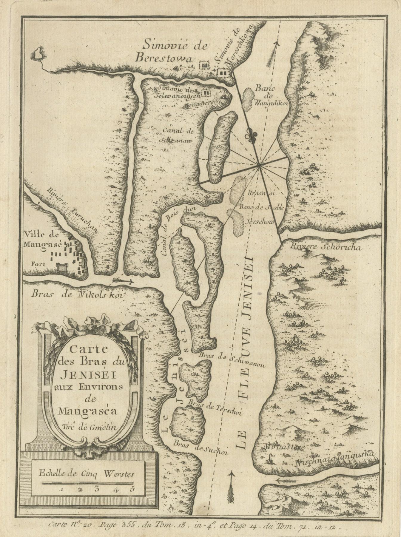
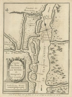
- Antique Map of the Yenisei River in Siberia, Russia, 1768By PrevostLocated in Langweer, NLAntique map titled 'Carte des Bras du Jenisei (..)'. Map of the Yenisei River and surroundings, Siberia. This print originates from volume 18 of 'Histoire generale des voyages (..)' ...Category
Antique 18th Century Maps
MaterialsPaper
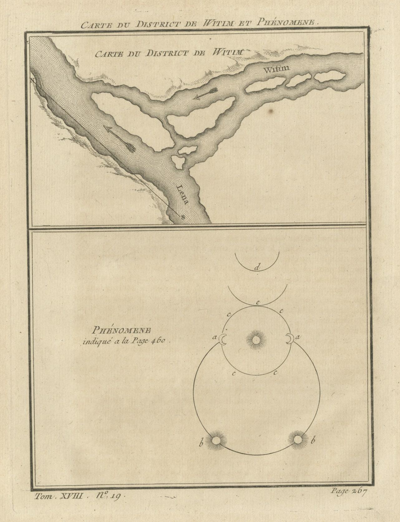
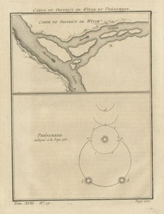
- Antique Map of the Vitim and Lena Rivers, Russia, 1768By PrevostLocated in Langweer, NLAntique map titled 'Carte du District de Witim et Phénomene (..)'. Map of the confluence of the Vitim and Lena rivers, and an illustration of atmospheric phenomena. This print origin...Category
Antique 18th Century Maps
MaterialsPaper
- Antique Map of the Rhine and Moselle River Region in Germany and France, c.1680Located in Langweer, NLAntique map titled 'Tabula Geographica qui Pars Meridionalis sive Superior Rheni, Mosae et Mosellae (..).' Detailed map of the Rhine and Moselle River regions and contigous parts...Category
Antique 17th Century Maps
MaterialsPaper
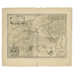
- Antique Map of the Region of Cambrai in France, c.1630Located in Langweer, NLAntique map titled 'l'Archevesche de Cambray'. Decorative map of the region of Cambrai, France. Includes the cities of Cambrai, Valencienes, Douai, and Bouchain. Artists and Engrav...Category
Antique 17th Century Maps
MaterialsPaper
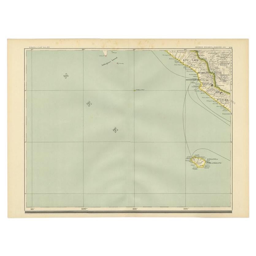
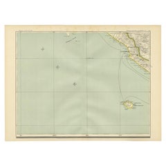
- Antique Map of the Region of Bengkulu in Indonesia, 1900Located in Langweer, NLAntique map of the region of Benkulu, Sumatra. Also depicting Enggano Island. This map originates from 'Atlas van Nederlandsch Oost- en West-Indië' by I. Dornseiffen. Artists and E...Category
20th Century Maps
MaterialsPaper
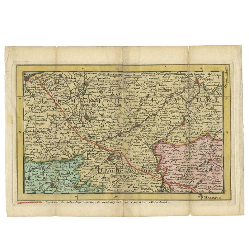
- Antique Map of the Region of Flanders in Belgium, 1737Located in Langweer, NLUntitled map of the region of Flanders, Belgium. This map originates from 'Nieuw en beknopt Kaart-Boekje vertoonende de XVII. Nederlandse Provintien (..)'. Artists and Engravers: A...Category
Antique 18th Century Maps
MaterialsPaper


You May Also Like
- Original Antique Map of Russia By Arrowsmith. 1820Located in St Annes, LancashireGreat map of Russia Drawn under the direction of Arrowsmith Copper-plate engraving Published by Longman, Hurst, Rees, Orme and Brown, 1820 Unframed.Category
Antique 1820s English Maps
MaterialsPaper
- 17th Century Hand Colored Map of the Liege Region in Belgium by VisscherBy Nicolaes Visscher IILocated in Alamo, CAAn original 17th century map entitled "Leodiensis Episcopatus in omnes Subjacentes Provincias distincté divisusVisscher, Leodiensis Episcopatus" by Nicolaes Visscher II, published in Amsterdam in 1688. The map is centered on Liege, Belgium, includes the area between Antwerp, Turnhout, Roermond, Cologne, Trier and Dinant. This attractive map is presented in a cream-colored mat measuring 30" wide x 27.5" high. There is a central fold, as issued. There is minimal spotting in the upper margin and a tiny spot in the right lower margin, which are under the mat. The map is otherwise in excellent condition. The Visscher family were one of the great cartographic families of the 17th century. Begun by Claes Jansz Visscher...Category
Antique Late 17th Century Dutch Maps
MaterialsPaper
- The Normandy Region of France: A 17th C. Hand-colored Map by Sanson and JaillotBy Nicolas SansonLocated in Alamo, CAThis large hand-colored map entitled "Le Duché et Gouvernement de Normandie divisée en Haute et Basse Normandie en divers Pays; et par evêchez, avec le Gouvernement General du Havre ...Category
Antique 1690s French Maps
MaterialsPaper
- 17th Century Hand-Colored Map of a Region in West Germany by JanssoniusBy Johannes JanssoniusLocated in Alamo, CAThis attractive highly detailed 17th century original hand-colored map is entitled "Archiepiscopatus Maghdeburgensis et Anhaltinus Ducatus cum terris adjacentibus". It was published ...Category
Antique Mid-17th Century Dutch Maps
MaterialsPaper
- Map of the Republic of GenoaLocated in New York, NYFramed antique hand-coloured map of the Republic of Genoa including the duchies of Mantua, Modena, and Parma. Europe, late 18th century. Dimension: 25...Category
Antique Late 18th Century European Maps
- Antique Map of Principality of MonacoBy Antonio Vallardi EditoreLocated in Alessandria, PiemonteST/619 - "Old Geographical Atlas of Italy - Topographic map of ex-Principality of Monaco" - ediz Vallardi - Milano - A somewhat special edition ---Category
Antique Late 19th Century Italian Other Prints
MaterialsPaper


Recently Viewed
View AllMore Ways To Browse
18th Century French Petite Furniture
Paul Le More
Carte Paris
Antique Maps Of Russia
Nicolas Russian
Antique Riviere
Long Riviere
Antique Map Art Collectibles
Antique Maps Art Collectibles
Rubens Engraving
Antique Australian Maps
Antique Map Of Australia
Antique Australian Map
Antique Furniture In The Philippines
Large Framed Antique Maps
Antique Filipino
Antique Map Japan
Political Map